| April 12 2019 |
Central U.S. Storm (10-12 April, 2019)
By: David Hamrick, WPC Meteorologist
Meteorological Overview:
Rapid surface cyclogenesis occurred over eastern Colorado late on April 10th in response to an amplifying upper level trough that was situated across the Great Basin. This surface low was initially slow moving as the upper level trough evolved into a closed low and deepened, with a maximum intensity of 982 mb over central Kansas at 00Z on April 11th prior to the surface low becoming occluded. Many reports referred to this as a “bomb cyclone”, but it was not as strong as the historic March blizzard a month earlier, and did not have a 24 mb drop in pressure in 24 hours.
Strong warm air advection ahead of the developing surface low transported an unseasonably moist air mass northward, providing anomalous moisture north of the developing occlusion. A potent deformation band became established to the northwest of the surface low, with mesoscale ascent being produced by 850-500mb frontogenesis along with the presence of a TROWAL. With the TROWAL axis pivoting in place as the low slowly progressed eastward across Kansas, the duration of heavy snow was maximized. Dynamic cooling in the lower troposphere resulted in a changeover from initially rain to all snow over much of South Dakota, where the greatest snow totals became realized.
Once the column cooled enough for the initial rain to change to snow across South Dakota and northern Nebraska, blizzard conditions developed as the surface low intensified. Deep layer ascent within the dendritic growth zone and the presence of negative equivalent potential vorticity (-EPV) led to areas of enhanced snowfall rates of 1 to 3 inches per hour across northeastern South Dakota, with enough convective elements to produce some instances of thunder snow. Farther to the north and east, theta-e advection within the TROWAL produced widespread moderate to heavy snow that was more stratiform in nature.
Impacts:
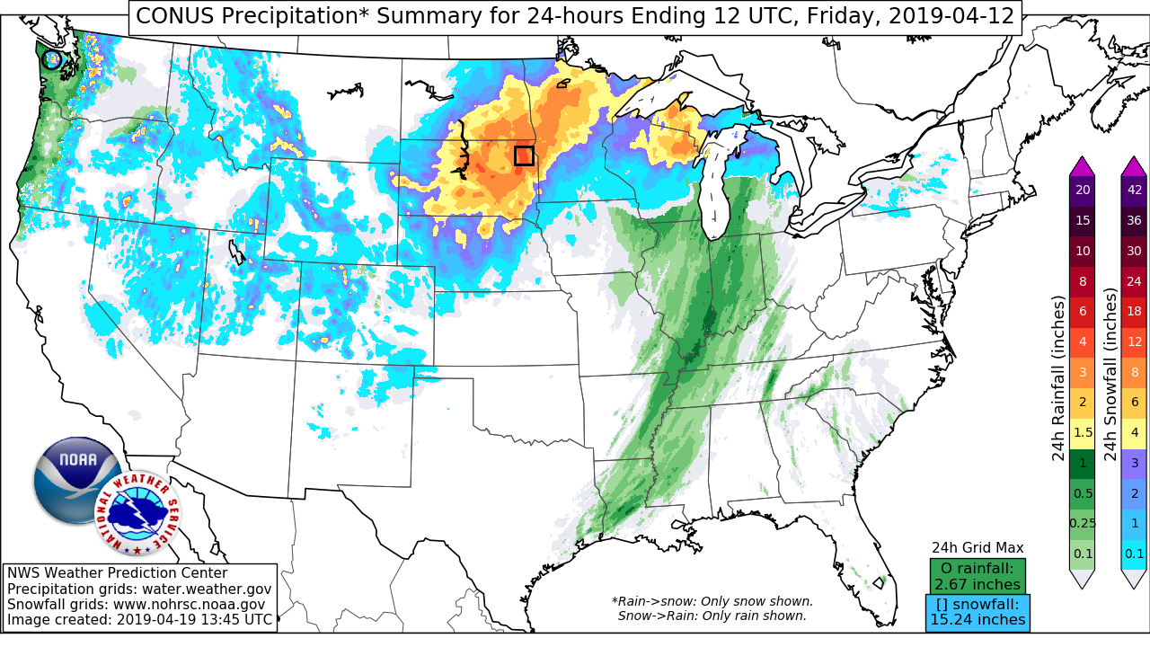
The snowfall totals for this event were quite anomalous by mid-April standards, even for locations that typically receive snow during that time of year. The greatest snowfall report was in Wallace, SD, where an impressive 30 inches was documented. The neighboring states of Montana and Wyoming also had reports in excess of 20 inches, including 25 inches near Alva, WY, and 23 inches at Badger Pass, MT. Although this event will be remembered for the record breaking snow across South Dakota, there was also a corridor of significant freezing rain from southeastern South Dakota to southern Wisconsin, with accretion up to half an inch observed near the Iowa/Minnesota border. There were also damaging winds given the tight pressure gradient that developed, with a gust of 107 mph near the town of Pueblo West, CO, and 88 mph at South Franklin Peak, TX.
There were numerous flight cancellations as a result of the blizzard, including about 700 flights at Denver International Airport alone. Long stretches of multiple interstates were shut down from drifting snow and high winds, particularly across Colorado, South Dakota, and Minnesota. Power outages were also extensive, with up to 90,000 households affected immediately following the storm.


