


| February 13 2024 |
Southern Plains to Northeast Winter Storm: (2/10/24 - 2/13/24)
By: Peter Mullinax, WPC Meteorologist
Meteorological Overview:
The origins for this infamous Northeast winter storm began in the Southwest on February 10 when a large upper low over northern Arizona tracked east towards the southern High Plains. Positive vorticity advection out ahead of the upper low fostered strong vertical ascent aloft over the southern High Plains that, when combined with a pronounced plume of subtropical moisture in the 850-500mb layer, led to no shortage of precipitation over the South Central U.S. At the surface, low pressure formed along an 850mb frontal boundary positioned over the TX/NM border that strengthened further by February 11 as the 700mb low reached southeast New Mexico. Subtropical moisture wrapped around the northern flank of the 700mb low which combined with strong upslope flow resulted in periods of moderate-to-heavy snow in the Southern Rockies. Eventually, a narrow band of 850-700mb frontogenesis on the northern flank of the 700mb low spawned a deformation axis of heavy snow from east-central New Mexico and the lower Texas Panhandle to south-central Oklahoma on February 11.
As this storm system moved east, snow became less of an issue across the Tennessee Valley and Mid-South due to the lack of sufficiently cold air. However, the 500mb disturbance driving this storm system across the South would go on to be the primary feature in causing heavy snow over the northern Mid-Atlantic and southern New England the night of February 12 and into the day on February 13. This was not always the case, however, as just 48 hours leading up to the event, forecast guidance was favoring a more northerly storm track that would become one of the more dramatic shifts in forecast guidance inside of 48 hours for a Northeast winter storm unfolding in recent memory. Roughly 48 hours before the start of the event, most ensemble guidance was keying in on northern Pennsylvania, Upstate New York, and central New England as having the best odds of receiving heavy snow that would exceed these regions snowfall warning criteria. There were two primary factors that caused the dramatic shift south. The first is that the primary upper level feature tracking across the Mid-South was coming in less amplified, leading to not only a weaker southern storm system but a lack of convection within the warm sector to help sharpen up the upper level trough axis. The second was an approaching northern stream upper level trough over the Great Lakes that trended stronger and more progressive. This caused stronger confluence over northern New England and further forced the storm to track only so far north along the Mid-Atlantic coast. In summary, these two features led to dramatic southward shifts in guidance inside of 48 hours of the storm’s arrival, leading to significant reductions in the snowfall forecast across Upstate New York, northern Pennsylvania, and into New England.
While the event did not turn out as forecast in these areas, the synoptic and mesoscale setup leading into the evening of February 12 still supported heavy snowfall rates from southern Pennsylvania and the Lehigh Valley to northern New Jersey. The surface analysis at 00Z Feb 13 showed a series of 996mb surface lows in eastern Tennessee that were out in front of a closed 500mb low tracking through western Tennessee. Vertical ascent was maximized the night of February 12 and early February 13 as a pair of 250mb jet streaks (one in the Southeast, another over New England) placed both of the diffluent jet streak quadrants over the northern Mid-Atlantic. In addition, 850-700mb frontogenesis was unfolding from southern Pennsylvania to the Lehigh Valley and a narrow band of exceptionally heavy snowfall rates (rates topping 3”/hr in some cases) formed overhead. By 12Z February 13, a deepening 850mb low was positioned near Atlantic City, NJ with a robust deformation axis located on the northern flank of the 850mb low. Heavy snowfall ensued from the Lower Hudson Valley and northern New York City suburbs on east into central Connecticut, south-central Massachusetts, and Rhode Island. Snow would wind down by the evening of February 13 as the 850mb low continued to intensify as it tracked south of Nova Scotia.
Impacts:
From a meteorological perspective, this event shined light on the growing use of probabilistic guidance in watch decision making and IDSS for meteorological setups that are highly susceptible to subtle reductions (or additions) in latent heat release from convection to the south and east of the storm track. The same can be said in split flow setups such as this one where the growing influence from a northern stream disturbance can, depending on the tilt/speed/depth of the approaching trough, dramatically suppress or amplify the storm track. While this event is a “bust” for those areas in north-central Pennsylvania, the Southern Tier of New York, and central New England, the same meteorological factors that led to enhanced messaging for a disruptive winter storm days in advance still transpired for areas farther south. This event serves as a foundational winter storm that will likely be referenced for years to come from the national to local level to spur additional research not only in the modeling of these events, but also in the probabilistic forecasting and messaging to decrease the chances of having these dramatic shifts in forecast guidance in the future.
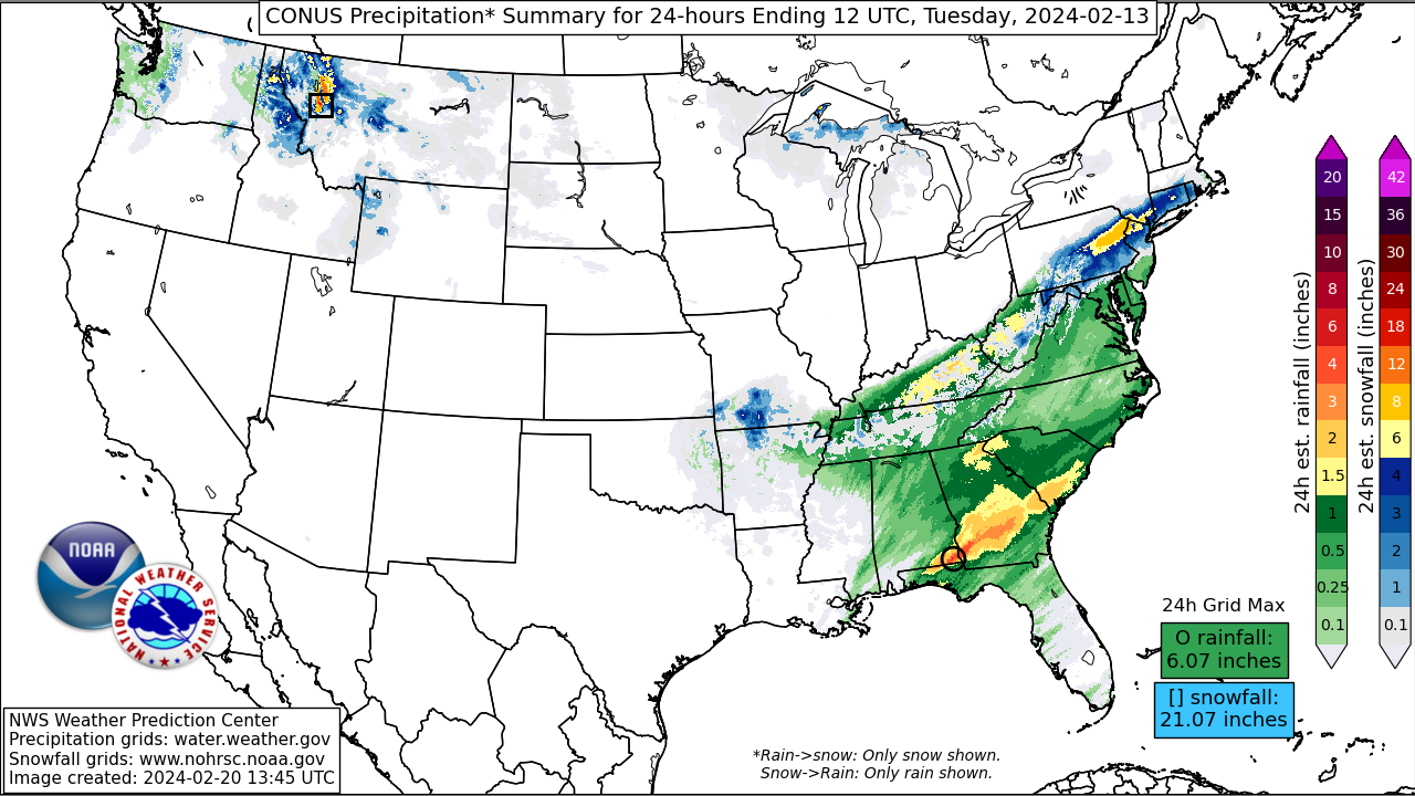
Now in terms of impacts to communities, businesses, and travel; schools were closed throughout just about all of these impacted communities the day of February 13. In terms of totals, over a foot of snow fell from eastern Pennsylvania to southern New England with Farmington, CT reporting as much as 15.5 inches. Dating back to when the storm was in the southern High Plains, as much as 19.5 inches fell near Bonito Lake in the Sacramento Mountains of New Mexico and 14 inches in Plainview, Texas. Travel impacts included numerous auto accidents, even in areas that saw snowfall totals only between 2-4 inches, such as northern Virginia, central Maryland, and along the I-95 corridor from Baltimore to Trenton. In Cumberland County, Pennsylvania the northbound lane of Interstate 81 was closed the morning of February 13. Around 1,200 flights were canceled in airports throughout the Northeast and over 150,000 customers were left without power (around 130,000 customers alone were in southeast Pennsylvania). Tragically, there was one fatality in Newberry Township, Pennsylvania when a man operating a snowmobile hit a downed utility pole. In eastern New Mexico and in the areas south of Amarillo and north of Lubbock, heavy snow and gusty winds caused hazardous travel conditions due to snow covered roads and significantly reduced visibilities.