| January 01 2022 |
Intermountain West to Great Lakes Winter Storm (12/30/2021 - 1/1/2022)
By: Allison Santorelli, WPC Meteorologist
Meteorological Overview:
A significant winter storm traversed much of the country from west to east between December 30, 2021 and January 1, 2022. This storm system brought significant mountain snow to the Intermountain West and central/southern Rockies and a swath of heavy snow across the central Plains, middle Mississippi Valley, and into the lower Great Lakes. Arctic high pressure spilled into the central U.S. following the storm, ushering in much below normal temperatures and dangerously cold wind chills well below zero leading to blowing and drifting snow and hazardous road conditions in areas where it had snowed. In the warm sector of this storm, heavy rain fell from the lower Mississippi Valley to the Central Appalachians with numerous severe weather and tornado reports across the Tennessee Valley on New Years Day.
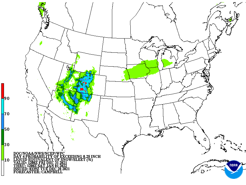
During the day on December 30, 2021, an upper level shortwave was pushing through the Northwest U.S.. This generally brought light to moderate snowfall for higher elevations of the Pacific Northwest, northern Rockies, and intermountain West. By that evening, and especially into Friday, December 31, the shortwave began to sharpen and a strong upper level jet streak had formed over the southern Rockies and into the south-central Plains. This placed the Colorado Rockies within the favorable left exit region, while at the surface, warm air advection and upslope into eastern Colorado helped intensify snowfall over and just east of the Colorado Rockies on New Years Eve. The snow across the Rockies continued to fall throughout the day on Friday, eventually coming to an end during the early morning hours of Saturday, January 1, 2022.
The shortwave trough across the West deepened further as it drifted over the Rockies on New Year's Day. At the surface, a quasi-stationary frontal boundary was draped from the south-central Plains through the Midwest with a wave of low pressure riding northeastward along the front. High pressure behind the front across the northern tier of the U.S. was supplying a sufficiently cold air mass for snow. Heavy snow began falling across parts of the central Plains during the morning of Jan 1, and progressed steadily northeastward during the day into the Mid-Mississippi Valley and upper Great Lakes coinciding with an area of mid-level frontogenesis. Just to the south of the snow axis and closer to the surface front, a narrow region of light to moderate ice (generally less than a tenth of an inch) was observed from portions of eastern Kansas into the Ohio Valley. Snow also fell across portions of the lower Great Lakes, with enhanced lake effect bands downwind of lakes Erie and Ontario. Snow associated with this system had come to an end by early morning on Jan 2.
The WPC forecast first started showing signs of a significant snow event in the Rockies on day 6 with some areas of greater than 50 percent probabilities highlighted in the Winter Weather Outlook. From the central Plains into the Great Lakes, it really wasn’t until day 3 or 4 when the WPC winter outlooks and the day 3-7 hazards chart started showing potential for impactful snow. As the storm moved into the short range period, the Winter Storm Severity Index began highlighting a widespread area of moderate to major winter storm impacts from northern Kansas/southeast Nebraska and eastward to Chicago.
Impacts:
Across both the Intermountain West and Rockies, 1-2 feet of snow fell in the highest terrain. As much as 3 to 4 feet of snow fell in the highest elevations of the Colorado Rockies, with generally 4-8” (locally higher) reported at lower elevations and in the foothill regions. Denver tied its snowiest New Years Eve on record set back in 1886, with 4.5” reported before midnight (and some additional accumulation after midnight). Several traffic delays and accidents were reported across the region, with some road closures necessary due to stalled out vehicles in the snow. Maybe one positive aspect of this storm is that it brought an end to a devastating wildfire the day before near Boulder, CO, helping firefighters extinguish any remaining fires.
Farther east, a swath of modest snow accumulations, generally amounting to 3-8 inches, with locally higher amounts, was observed from central Kansas into southern Lower Michigan and parts of far northern New England. The highest recorded total in this region was 9 inches out of Humeston, IA (located south of Des Moines). The 4.1 inches reported at Chicago O’Hare International Airport made it the snowiest New Years Day on record since 1985 and only the sixth New Years Day since 1884 with more than 3” of snow. The combination of a fluffy snow, gusty winds, and also a period of icing before the snow, made road travel difficult to impossible in some parts of the region. Numerous traffic incidents and snow covered roads were reported with major delays observed at area airports as well.. Up to a couple of inches of snow fell even as far south as the Texas Panhandle with this event as well.


