Excessive Rainfall Discussion
NWS Weather Prediction Center College Park MD
404 PM EDT Sun May 4 2025
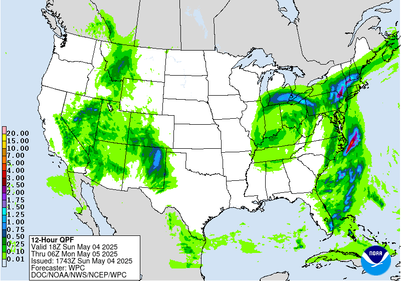
Day 1
Valid 20Z Sun May 04 2025 - 12Z Mon May 05 2025
...THERE IS A SLIGHT RISK OF EXCESSIVE RAINFALL FOR PORTIONS OF
EASTERN NEW MEXICO...
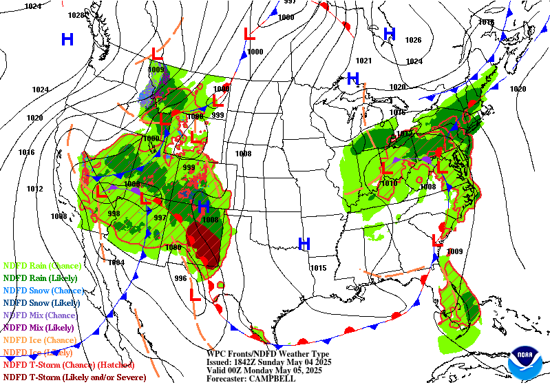
...20Z Special Update...
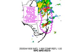
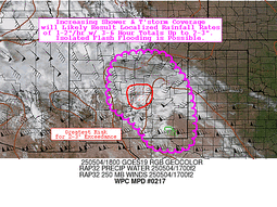
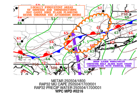
Marginal Risk areas have been added to portions of the Southwest as
well as for southern Florida. See MPDs 218 at
wpc.ncep.noaa.gov/metwatch/metwatch_mpd_multi.php?md=0218&yr=2025
for the Southwest and MPD 219 at
wpc.ncep.noaa.gov/metwatch/metwatch_mpd_multi.php?md=0219&yr=2025
for south Florida for more details.
Day 1 threat area:
www.wpc.ncep.noaa.gov/qpf/94epoints.txt
Excessive Rainfall Discussion
NWS Weather Prediction Center College Park MD
404 PM EDT Sun May 4 2025
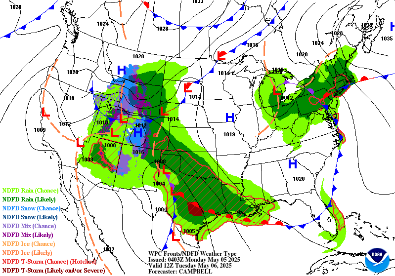
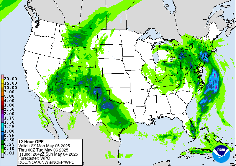
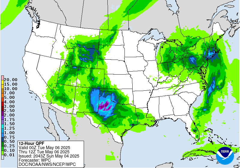
Day 2
Valid 12Z Mon May 05 2025 - 12Z Tue May 06 2025
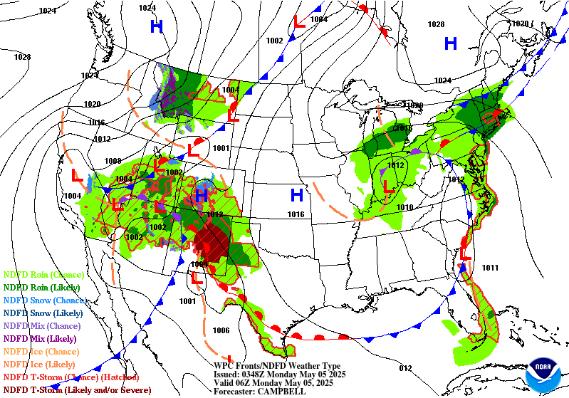
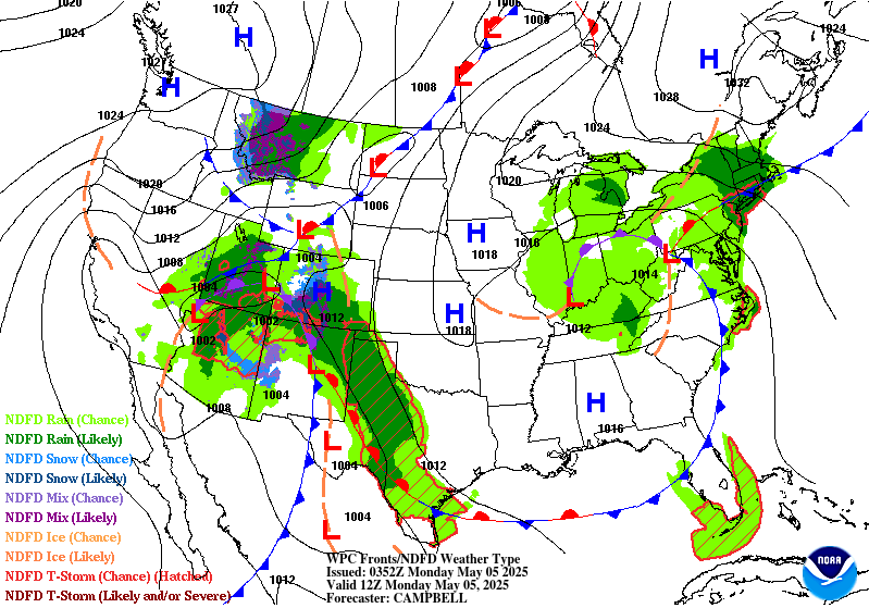
...THERE IS A SLIGHT RISK OF EXCESSIVE RAINFALL OVER PORTIONS OF
THE SOUTHERN HIGH PLAINS...
...2030Z Update...
...Southern High Plains...
The Slight Risk area was expanded northwestward to include more of
the Texas Panhandle and far eastern New Mexico with this update and
in coordination with ABQ/Albuquerque, NM and AMA/Amarillo, TX
forecast offices. Showers and thunderstorms from the overnight
period will likely be ongoing along the NM/TX border at the start
of the period Monday morning, with periodic flareups of additional
convection expected throughout the day in this same area. Following
occasional daytime convection, a new MCS is likely to form during
the evening across west Texas and eastern NM and track northward
through the night. Thus, portions of the area, likely centered
around Lubbock/southern Texas Panhandle, will likely see multiple
rounds of heavy rain through Monday night. Soils in this area are
well above normal for moisture, especially for the eastern
Panhandle closer to Oklahoma. Therefore lesser amounts of rain than
normal will be needed to result in flash flooding.
...Northeast...
The Marginal Risk across portions of the Northeast was maintained
with few changes with this update. With coordination from
OKX/Upton, NY; ALY/Albany, NY; BOX/Taunton, MA; and PHI/Mt. Holly,
NJ forecast offices, a Slight Risk upgrade was considered for
portions of the area, with numerous models forecasting a swath of
1-2 inches of rain from NYC north and east through Long Island,
much of Connecticut, and the lower Hudson Valley and Catskills.
Despite that, very nominal instability and dry antecedent soils
conditions and low river levels were determined to likely prevent
much flash flooding outside of the most flood prone areas, so the
Marginal was maintained. Upslope will be a contributing factor to
locally heavier and steadier rain across Connecticut and the lower
Hudson Valley into the Catskills, but here too flash flooding
should be confined to only isolated areas. Should instability
increase or total rainfall increase a targeted Slight Risk may
still be needed with future updates.
Wegman
...Previous Discussion...
Texas into New Mexico...
A closed upper low over the Desert Southwest will continue to
meander eastward on Monday. Confidence remains in a focused area
for repeating heavy rainfall south from the TX Panhandle to the NM
border where a Slight Risk remains without many changes...with main
activity occurring once again around the time of maximum daytime
heating and then persisting into or through the night. The suite
of 04/00Z numerical guidance still shows the magnitude of
precipitable water values to exceed 2 sigma by 00Z Tuesday with the
1.25" precipitable water line reaching the Caprock. The 12Z QPF
consensus is for 2-4" over a sizable area just south of the TX
Panhandle...with locally higher amounts embedded in the broader QPF
area.
Mojave Desert through Southern Utah...
Numerous showers with embedded daytime and evening thunderstorms is
still expected as upper low continues to meander over Arizona as
it begins to fill. Moisture is still anomalous for this time of
year...being some 2 to 3 standardized anomalies above climatology
for early May...but concern would be greater for excessive rainfall
if the actual values of precipitable water values were greater and
intense rainfall rates would be sustained for a longer duration.
As a result...the risk of excessive rainfall appears to be non-zero
but not enough to warrant a Marginal risk area based on
coordination with local offices.
Northern Mid-Atlantic into southern New England...
Closed low will continue to meanders across portions of the Upper
OH Valley through Monday night. Continued onshore flow brings the
threat for repeating locally heavy rain over the northern Mid-
Atlantic into southern New England which will have seen some heavy
rain between now and then. A Marginal Risk is maintained.
Bann
Day 2 threat area:
www.wpc.ncep.noaa.gov/qpf/98epoints.txt
Excessive Rainfall Discussion
NWS Weather Prediction Center College Park MD
404 PM EDT Sun May 4 2025
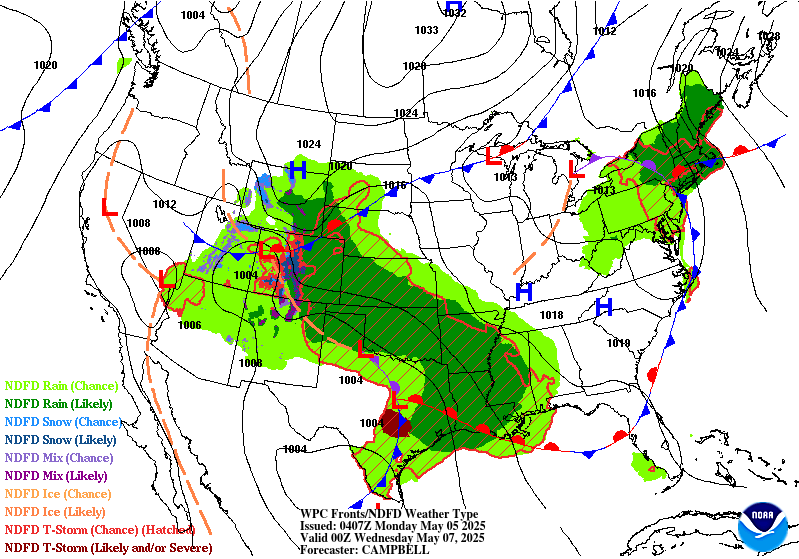
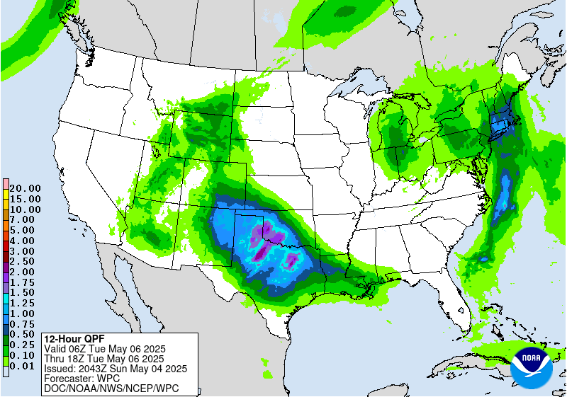
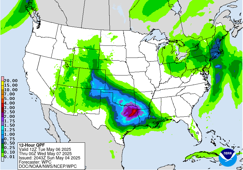
Day 3
Valid 12Z Tue May 06 2025 - 12Z Wed May 07 2025
...THERE IS A MODERATE RISK OF EXCESSIVE RAINFALL OVER PORTIONS OF
THE SOUTHERN MISSISSIPPI VALLEY/CENTRAL GULF COAST REGION...
...2030Z Update...
...Lower Mississippi Valley to the Colorado Front Range...
The inherited Moderate Risk area was greatly expanded with this
update, in keeping with numerous pieces of guidance, ensembles, and
means all favoring a significant thunderstorm training and heavy
rain event across the Arklatex and into central Mississippi. The
RRFS suggests multiple lines of storms will cross west to east
across the Moderate Risk area, starting in the north from northeast
Texas, along the Louisiana/Arkansas border, and then continuing
into Mississippi. The trailing (southwestern) portion of the line
will hang back as it is joined by additional storms over southeast
Texas that progress eastward.
The first line will start out at roughly a southwest to northeast
orientation, however, into Tuesday night, the lines will get
progressively more west-east oriented, meaning greater chance that
repeating lines of storms will move across Louisiana. Meanwhile the
outflow on the northern side of the complex of storms will allow
for continued lighter rains in northern areas that were hard hit
earlier in the evening, which will continue or worsen ongoing flash
flooding as a result of the earlier storms. While the RRFS is far
from a perfect solution as to who will get heavy rain and when,
given the footprint of heavy rain in the RRFS is at least similar
and in a roughly the same location as the heavy rain footprint in
the global models, it appeared to offer a good first guess as to
how the storm evolution will play out through the period.
The Moderate Risk area remains a lower-end Moderate for now until
there is better consensus (and likely southward shifts) in the area
of heaviest rainfall. By then it's possible portions of the area
may be considered in a higher-end Moderate Risk. For now...rainfall
amounts in this area should not reach High Risk levels, since there
is at least some southward movement for most of the storms with
time, so no one area sees heavy rains for an extended duration.
Further, it's possible that the training storms end up offshore of
the Louisiana coast should there be more dramatic southward shifts,
so the Moderate Risk was determined to be the appropriate risk
level for flash flooding. Should there be significant increases
with future runs, that are expected to be more concentrated, then
it's not completely out of the question that a targeted High Risk
may be needed with future updates.
While the heaviest rains will be associated with the moderate Risk
area in portions of the lower Mississippi Valley, a good amount of
that moisture and instability will be drawn northwestward ahead of
a strong shortwave trough associated with the slow-moving upper
level low over the 4 Corners region. This will extend an area of
heavy rain from the MCS/Moderate Risk region northwest across much
of Oklahoma and into southern Colorado. This in turn will lead to a
shearing front, but the heavy rainfall will be moving over areas
hard hit with prior flooding rains, particularly over Oklahoma and
the Panhandles. Thus, the Slight Risk extends well west into
southeastern Colorado, where upslope may play a role in producing
locally heavy rains along the Front Range, while the higher
elevations pick up heavy snow.
...Northeast...
A slow moving upper level low over the Midwest will continue to
pump Atlantic moisture into New England on Tuesday...a continuation
of periods of rain from the same system both today and on Monday.
By Tuesday, however, instability into and south of New England
will increase to up to 500 J/kg. While this amount of instability
is far from impressive, it will still be enough to allow for
convective showers and maybe some embedded thunderstorms to move
north up the coast and into New England. Antecedent soil moisture
conditions are likely to be significantly more favorable for the
development of flash flooding in this region considering the rain
expected there today through Monday. Thus, a Slight Risk upgrade is
possible in this area assuming there are increases in the forecast
rainfall once this period moves into the short-term and the CAMs
can analyze the system.
Wegman
...Previous Discussion...
Showers and thunderstorms capable of producing intense rainfall
rates and heavy/excessive rainfall will become more numerous
on Tuesday as height falls make their way out across Texas and as
the parent upper low ejects out over the Southern Plains. With
increasing flow off the Gulf drawing deeper moisture on-
shore....the convection should become increasingly efficient
rainfall makers.especially over portions of Louisiana and
Mississippi. There is still some differences in where models place
the heaviest rainfall...with the GFS and Canadian favoring a faster
solution while the EC/UK favoring the axis from eastern Texas into
northern Louisiana. This forecast cycle nudged the Moderate risk
area a bit eastward but not as far east as the GFS/Canadian.
Bann
Day 3 threat area:
www.wpc.ncep.noaa.gov/qpf/99epoints.txt
Extended Forecast Discussion
NWS Weather Prediction Center College Park MD
306 PM EDT Sun May 4 2025
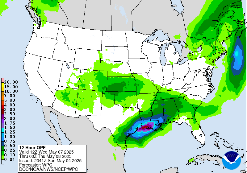
By Wednesday, the start of the period, the heaviest rains are
likely to focus near the central Gulf Coast pooling along a frontal
boundary. Heavy rain rates are likely along the cusp of the
instability gradient and training storms are possible generally in
southern Louisiana and vicinity. However, there are some competing
factors for flooding to be too widespread Wednesday, including
model spread with some focusing the front and thus the rainfall
offshore. The farther south axis of heaviest rain compared to the
short range puts the highest QPF atop drier antecedent conditions,
along with higher flash flood guidance in swamplands. Thus
maintained the Slight Risk across much of the Lower Mississippi
Valley rather than any upgrades at this time and will continue to
monitor trends. Urban areas could still be vulnerable to flash
flooding. Heavy rain could persist into Thursday along the central
Gulf Coast and into parts of the Southeast. Again, model spread and
higher flash flood guidance limits flooding potential for now and
will maintain a Marginal Risk for these areas on Day 5/Thursday.
Rain and thunderstorms are likely to persist across the Southeast
late week into the weekend.
Meanwhile farther west and north, precipitation including higher
elevation snow could continue into Wednesday for the south-central
Rockies. Areas of rain are also likely across the central Plains to
Middle Mississippi Valley Wednesday-Thursday and lingering into
Friday in the Lower Mississippi Valley. Areas of rain are also
possible in the northeastern U.S. at times later this week into the
weekend. On Wednesday, some wrapback moisture and instability on
the backside of the associated surface low could allow for modest
rain in Interior Northeast, but with several model and QPF cycles
showing this rain staying well under an inch, removed the Marginal
Risk as any flooding chances should be below 5 percent.
The upper low over the Southwest early in the period will result
in lingering below normal temperatures for the Southwest and south-
central Plains where daytime highs could be 10-20 degrees below
normal. This should moderate with time but may still remain
modestly below normal into late week for the southern Plains. Upper
ridging building over the West as the upper low shifts east will
allow for expanding coverage of above normal temperatures there as
the week progresses, including 100 degree temperatures in the
Desert Southwest. Above average temperatures will stretch into the
northern tier as well, with highs reaching the 70s and 80s in the
northern Plains to Upper Midwest.
Tate/Santorelli
Extended Forecast Discussion
NWS Weather Prediction Center College Park MD
306 PM EDT Sun May 4 2025
By Wednesday, the start of the period, the heaviest rains are
likely to focus near the central Gulf Coast pooling along a frontal
boundary. Heavy rain rates are likely along the cusp of the
instability gradient and training storms are possible generally in
southern Louisiana and vicinity. However, there are some competing
factors for flooding to be too widespread Wednesday, including
model spread with some focusing the front and thus the rainfall
offshore. The farther south axis of heaviest rain compared to the
short range puts the highest QPF atop drier antecedent conditions,
along with higher flash flood guidance in swamplands. Thus
maintained the Slight Risk across much of the Lower Mississippi
Valley rather than any upgrades at this time and will continue to
monitor trends. Urban areas could still be vulnerable to flash
flooding. Heavy rain could persist into Thursday along the central
Gulf Coast and into parts of the Southeast. Again, model spread and
higher flash flood guidance limits flooding potential for now and
will maintain a Marginal Risk for these areas on Day 5/Thursday.
Rain and thunderstorms are likely to persist across the Southeast
late week into the weekend.
Meanwhile farther west and north, precipitation including higher
elevation snow could continue into Wednesday for the south-central
Rockies. Areas of rain are also likely across the central Plains to
Middle Mississippi Valley Wednesday-Thursday and lingering into
Friday in the Lower Mississippi Valley. Areas of rain are also
possible in the northeastern U.S. at times later this week into the
weekend. On Wednesday, some wrapback moisture and instability on
the backside of the associated surface low could allow for modest
rain in Interior Northeast, but with several model and QPF cycles
showing this rain staying well under an inch, removed the Marginal
Risk as any flooding chances should be below 5 percent.
The upper low over the Southwest early in the period will result
in lingering below normal temperatures for the Southwest and south-
central Plains where daytime highs could be 10-20 degrees below
normal. This should moderate with time but may still remain
modestly below normal into late week for the southern Plains. Upper
ridging building over the West as the upper low shifts east will
allow for expanding coverage of above normal temperatures there as
the week progresses, including 100 degree temperatures in the
Desert Southwest. Above average temperatures will stretch into the
northern tier as well, with highs reaching the 70s and 80s in the
northern Plains to Upper Midwest.
Tate/Santorelli


