Excessive Rainfall Discussion
NWS Weather Prediction Center College Park MD
856 PM EDT Thu May 1 2025
Day 1
Valid 01Z Fri May 02 2025 - 12Z Fri May 02 2025
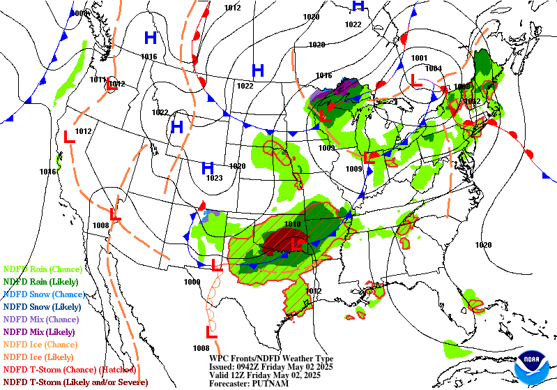
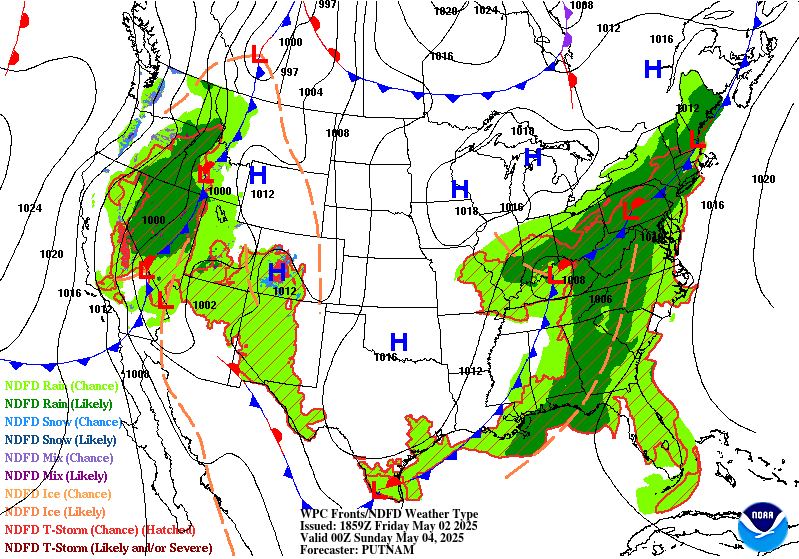
...THERE IS A SLIGHT RISK OF EXCESSIVE RAINFALL FOR SOUTHERN
OKLAHOMA AND FAR WESTERN ARKANSAS, SOUTH-CENTRAL TEXAS, AS WELL AS
FOR PORTIONS OF THE CENTRAL APPALACHIANS...
...01Z Update...
A Slight Risk was added to portions of south-central Texas, from
the U.S.-Mex border eastward through the Austin-San Antonio metros
to College Station, where slow-moving, heavy-rainfall producing
storms have increased in coverage this evening. Supported by moist,
southeasterly low level inflow and high instability, some of these
storms have shown rainfall rates of 2-3 in/hr, with MRMS indicating
estimated totals of over 4 inches in the past 3 hours. There is
concern that conditions will remain favorable for continued
development, with the heavy rainfall threat persisting longer and
across a broader area than most of what the CAMs, including the
HRRR, indicate. Given the observed rainfall rates and the rainfall
already received in some areas, a Slight Risk was added. Refer to
WPC MPD #206 for additional details concerning the threat across
parts of this area.
Also added a Marginal Risk across portions of central and southern
California, where an upper level low interacting with PWs of
0.75-1 inch is supporting showers and thunderstorms, mostly along
the high terrain from the southern Sierra Nevada to the coastal
ranges, including the San Gabriel and Sierra Madre. Some of these
storms are producing torrential downpours and isolated flooding
concerns. Storms are expected to diminish later this evening, but
may pose additional concerns, especially across areas recently
impacted by wildfires.
Elsewhere, more minor adjustments were made to the previous outlook
based on current observations and CAM guidance.
Pereira
...16Z Update...
Only very minor tweaks were needed to the Slight Risk areas across
the Southern Plains and central Appalachians. For the southern
Plains, the 12Z HiRes guidance shifted very slightly (10-20 miles)
north with tonight's expected MCS development across Oklahoma.
Given the high sensitivity of that entire area between Dallas and
Oklahoma City for heavy rainfall, the Slight Risk was maintained.
The 12Z HRRR followed previous runs suggesting there may be
training showers that get hung up on the southern end of the MCS
just north of the Red River, but by then the instability should be
largely used up and therefore rates should come down a bit. Given
that, the Slight was maintained with no upgrades...though it
wouldn't take much of an uptick in future guidance to possibly need
a targeted Moderate, depending on if the guidance can come into
better agreement on where the axis of heaviest rain will set up.
Over to the Central Appalachians, the guidance unfortunately
remains in poorer agreement than in the southern Plains. Expect
more widely scattered convection to impact the area starting this
afternoon, developing into one or more lines of storms by the
evening. Each line will be very progressive/fast-moving, so
individual storms will not have much of a flooding impact. However,
with multiple rounds of showers and storms expected in an area
recently hard hit with heavy rain, the multiple rounds of storms
may collectively add up to widely scattered instances of flash
flooding into this evening. The inherited Slight was trimmed in
MD/WV out of areas east of the Allegheny Front, which are
significantly drier and with higher FFGs than areas along and west.
Wegman
...Previous Discussion...
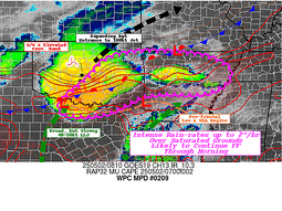
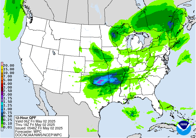
...Southern Plains...
Shortwave ejection out of the Southern Rockies will interact with a
cold front pressing south through the Central and Southern Plains
by the late-afternoon and evening hours Thursday through Friday
morning. A relevant theta_E differential will be aligned within
the confines of the boundary providing a suitable thermodynamic
alignment such that area convection anchors and pushes along the
west to east oriented instability gradient across Southern OK.
Majority of CAMs are in consensus of a heavy rainfall footprint
along and south of I-40, generally configured to the timing of the
cold front, shortwave interaction, and LLJ convergence signal. This
is primarily right around 00z when the convective threat enhances
with the integration of the nocturnal LLJ, a timing historically
prevalent for this time of year and this setup is no exception.
00z HREF neighborhood probs for >1" are relatively high (50-80%)
within the corridor extending from Southwest OK across the Red
River Basin towards the AR border. >2" is highest just north of the
river from I-35 on east, a testament to the timing of the
shortwave arrival and upscale growth of the convective threat as it
maneuvers to the east-southeast. Rainfall rates between 1-2"/hr are
most likely when assessing the hourly rate probs from the both the
NBM and HREF output, a rate assessment that is more than suitable
considering the blanket low FFG intervals due to the antecedent
moist soils from the past 36-48 hrs of rainfall. The areal QPF
footprint of >1" aligned within those lower FFG's pretty much
perfectly, a scenario that lends to a greater credence of a touch
higher risk category that what is normal the case for this setup.
The previous SLGT risk was relatively maintained with minor
adjustments on the edges pertaining to recent hi-res QPF and in
conjunction with the ML First Guess Fields.
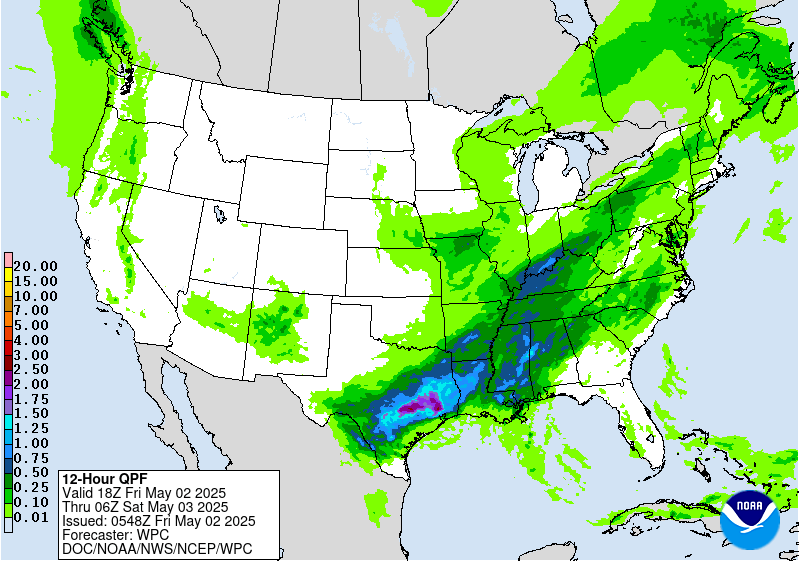
...Interior Mid Atlantic...
Shortwave trough currently positioned over the Southern Plains will
lift northeast through the Mississippi Valley with sights on the
Great Lakes region by the second half of the D1. Downstream, an
improved diffluent signature will align over the Ohio Valley and
points northeast allowing for regional ascent to boost convective
initiation in-of places within that diffluent core. The most
notable area for convective development lies within an established
theta_E tongue riding northward through the Appalachians Front
with poleward expansion into the southeastern Great Lakes. This
allowed for moisture rich air exuding PWAT anomalies between +2 and
+3 within the corridor extending through much of WV up through
Eastern OH and Western PA to the Lake Erie border. SBCAPE between
1500-2500 J/kg will be a common occurrence during peak diurnal
destabilization creating a corridor of enhanced thermodynamic
prospects to coincide with the arrival of the better mid-level
forcing downstream of the approaching trough. Regional shear will
be improving as well, especially within the confines of a shallow
warm front that will be lifting northward through the course of the
afternoon across the interior Mid Atlantic. Cell initiation will
begin between 18-00z today with greater multi-cell cluster coverage
likely to occur towards the back end of the above time frame due
to anchoring along the warm front as it approaches. Areas across
Western PA have been hit relatively hard recently with convective
rainfall adding to the areal decoupling of the FFG indices meaning
the prospects for flash flooding have increased with the arrival of
this next disturbance.
00z HREF neighborhood probs for >2" are between 30-50% across a
large section of Western PA extending south into the northern High
Country of WV, rooted in the Appalachians Front, an area notorious
for flashy rivers and smaller towns located within the valleys.
There was enough consensus to warrant an upgrade considering the
antecedent conditions, atmospheric environmental favorability, as
well as the increased probs denoting a locally heavy rain prospect
over the region. A SLGT risk has been added to much of Western PA
down into portions of the Central Appalachians.
Kleebauer
Day 1 threat area:
www.wpc.ncep.noaa.gov/qpf/94epoints.txt
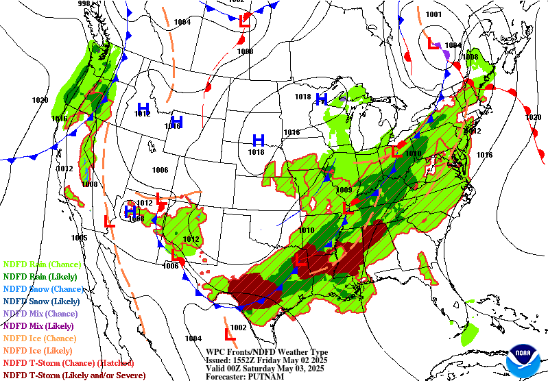
Excessive Rainfall Discussion
NWS Weather Prediction Center College Park MD
425 AM EDT Fri May 2 2025
Day 1
Valid 12Z Fri May 02 2025 - 12Z Sat May 03 2025
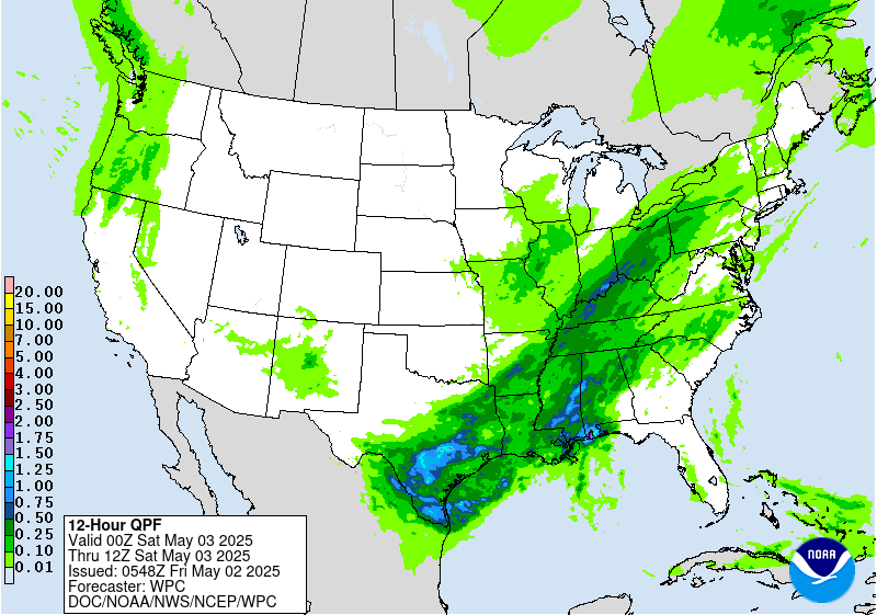
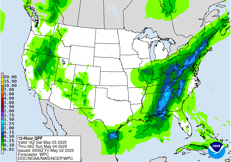
...THERE IS A SLIGHT RISK OF EXCESSIVE RAINFALL OVER PORTIONS OF
THE SOUTHERN PLAINS AND MID-SOUTH AND LOWER MISSISSIPPI...
Another round of thunderstorms is expected to develop along and
ahead of a southward moving cold front on Friday...with guidance
still focusing the greatest chances for excessive rainfall from
portions of the Mid-South into the Southern Plains Friday into
Friday night as weak waves propagate northeastward along the front.
Southerly low level flow will draw Gulf moisture northward...helping
increase precipitable water values ahead of the front to 1.5 to
1.75 inches at the time of the peak heating in a stripe from Texas
into southern Arkansas. Forecast soundings depict an atmosphere
supportive of rainfall rates exceeding 2 inches per hour. As
mentioned previously...the potential for a prolonged period of
training is fairly minimal so a Slight Risk still seems to cover
the potential. 00Z HREF neighborhood probabilities of 1-hour QPF
exceeding 2 inches were over 30 percent in parts of southeast TX
with lower probabilities extending into parts of Arkansas.
A Marginal Risk area surrounding the Slight Risk area extends as
far northeastward as parts of the Great Lakes. Precipitable water
values were generally at or below 1.25 inches ahead of the
advancing cold front but guidance still showed enough instability
to support showers and thunderstorms over an area that was still
had lingering hydrologic sensitivity following recent heavy
rainfall. In addition...the area will be underneath a right
entrance region of an upper level jet stream aiding upper level
support during the afternoon.
Farther west...there is also a Marginal risk of excessive rainfall
from late day and evening convection over the terrain of New
Mexico. The QPF is fairly modest but even modest rainfall rates
could result in isolated problems with run off...especially if the
rain falls on recent burn scars.
Bann
Day 1 threat area:
www.wpc.ncep.noaa.gov/qpf/94epoints.txt


