Excessive Rainfall Discussion
NWS Weather Prediction Center College Park MD
856 PM EDT Wed Apr 30 2025
Day 1
Valid 01Z Thu May 01 2025 - 12Z Thu May 01 2025
...THERE IS A MODERATE RISK OF EXCESSIVE RAINFALL FOR PORTIONS OF
NORTHEAST TEXAS AND NORTHWEST LOUISIANA...
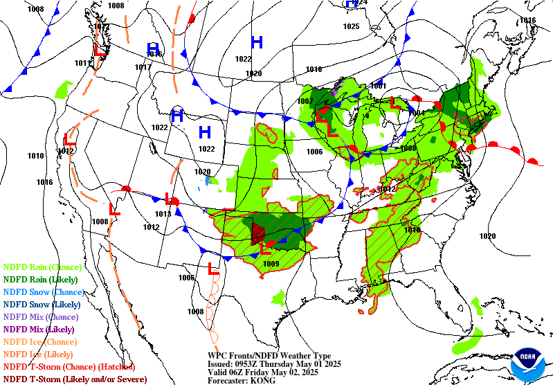
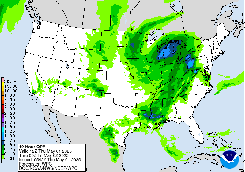
01Z Update...
Updates to the previous ERO were based upon recent runs of the
HRRR, the 18Z HREF, and current observation trends.
The greatest heavy rain and flash flooding concerns through the
evening hours focus along the southwest flank of ongoing
convection and a coincident slow-moving boundary from the ArkLaTex
southeastward back through the Waco area. Current radar shows
storms training along the boundary, with rainfall rates of 1-2
inches/hour within some of the stronger cells. Cell-training and
heavy rainfall will remain a concern for at least the next few
hours as deep layer flow is aligned with the boundary. The Moderate
Risk was adjusted to align with the training convection, which
agrees well with the higher HREF neighborhood probabilities for
additional accumulations of 3 inches or more during the
evening/overnight.
Farther to the north across Arkansas, the threat for heavy
rainfall and flash flooding is diminishing where the convective
line has become more progressive.
Areas back to the north and west, where the rainfall has ended,
were removed from the outlook.
Pereira
Day 1 threat area:
www.wpc.ncep.noaa.gov/qpf/94epoints.txt
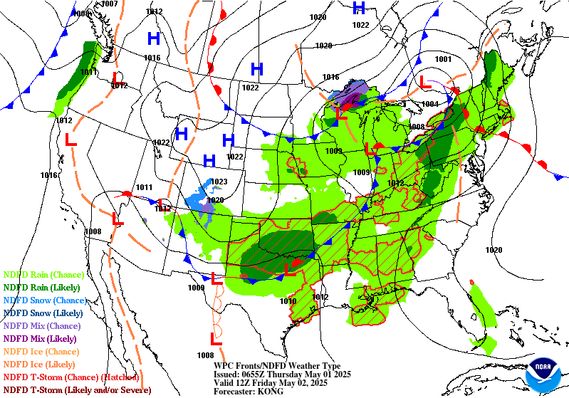
Excessive Rainfall Discussion
NWS Weather Prediction Center College Park MD
356 AM EDT Thu May 1 2025
Day 1
Valid 12Z Thu May 01 2025 - 12Z Fri May 02 2025
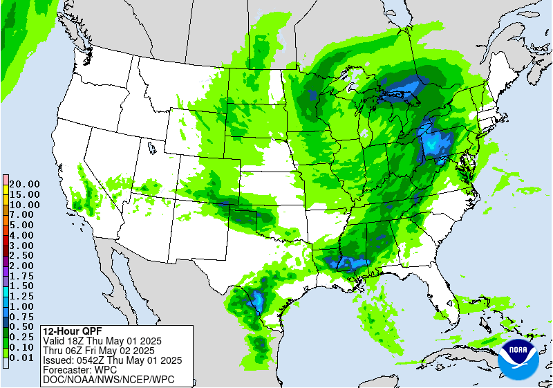
...THERE IS A SLIGHT RISK OF EXCESSIVE RAINFALL IN SOUTHERN
OKLAHOMA, FAR NORTH TEXAS, FAR WESTERN ARKANSAS, WESTERN
PENNSYLVANIA AND THE CENTRAL APPALACHIANS...
...Southern Plains...
Shortwave ejection out of the Southern Rockies will interact with a
cold front pressing south through the Central and Southern Plains
by the late-afternoon and evening hours Thursday through Friday
morning. A relevant theta_E differential will be aligned within
the confines of the boundary providing a suitable thermodynamic
alignment such that area convection anchors and pushes along the
west to east oriented instability gradient across Southern OK.
Majority of CAMs are in consensus of a heavy rainfall footprint
along and south of I-40, generally configured to the timing of the
cold front, shortwave interaction, and LLJ convergence signal. This
is primarily right around 00z when the convective threat enhances
with the integration of the nocturnal LLJ, a timing historically
prevalent for this time of year and this setup is no exception.
00z HREF neighborhood probs for >1" are relatively high (50-80%)
within the corridor extending from Southwest OK across the Red
River Basin towards the AR border. >2" is highest just north of the
river from I-35 on east, a testament to the timing of the
shortwave arrival and upscale growth of the convective threat as it
maneuvers to the east-southeast. Rainfall rates between 1-2"/hr are
most likely when assessing the hourly rate probs from the both the
NBM and HREF output, a rate assessment that is more than suitable
considering the blanket low FFG intervals due to the antecedent
moist soils from the past 36-48 hrs of rainfall. The areal QPF
footprint of >1" aligned within those lower FFG's pretty much
perfectly, a scenario that lends to a greater credence of a touch
higher risk category that what is normal the case for this setup.
The previous SLGT risk was relatively maintained with minor
adjustments on the edges pertaining to recent hi-res QPF and in
conjunction with the ML First Guess Fields.
...Interior Mid Atlantic...
Shortwave trough currently positioned over the Southern Plains will
lift northeast through the Mississippi Valley with sights on the
Great Lakes region by the second half of the D1. Downstream, an
improved diffluent signature will align over the Ohio Valley and
points northeast allowing for regional ascent to boost convective
initiation in-of places within that diffluent core. The most
notable area for convective development lies within an established
theta_E tongue riding northward through the Appalachians Front
with poleward expansion into the southeastern Great Lakes. This
allowed for moisture rich air exuding PWAT anomalies between +2 and
+3 within the corridor extending through much of WV up through
Eastern OH and Western PA to the Lake Erie border. SBCAPE between
1500-2500 J/kg will be a common occurrence during peak diurnal
destabilization creating a corridor of enhanced thermodynamic
prospects to coincide with the arrival of the better mid-level
forcing downstream of the approaching trough. Regional shear will
be improving as well, especially within the confines of a shallow
warm front that will be lifting northward through the course of the
afternoon across the interior Mid Atlantic. Cell initiation will
begin between 18-00z today with greater multi-cell cluster coverage
likely to occur towards the back end of the above time frame due
to anchoring along the warm front as it approaches. Areas across
Western PA have been hit relatively hard recently with convective
rainfall adding to the areal decoupling of the FFG indices meaning
the prospects for flash flooding have increased with the arrival of
this next disturbance.
00z HREF neighborhood probs for >2" are between 30-50% across a
large section of Western PA extending south into the northern High
Country of WV, rooted in the Appalachians Front, an area notorious
for flashy rivers and smaller towns located within the valleys.
There was enough consensus to warrant an upgrade considering the
antecedent conditions, atmospheric environmental favorability, as
well as the increased probs denoting a locally heavy rain prospect
over the region. A SLGT risk has been added to much of Western PA
down into portions of the Central Appalachians.
Kleebauer
Day 1 threat area:
www.wpc.ncep.noaa.gov/qpf/94epoints.txt
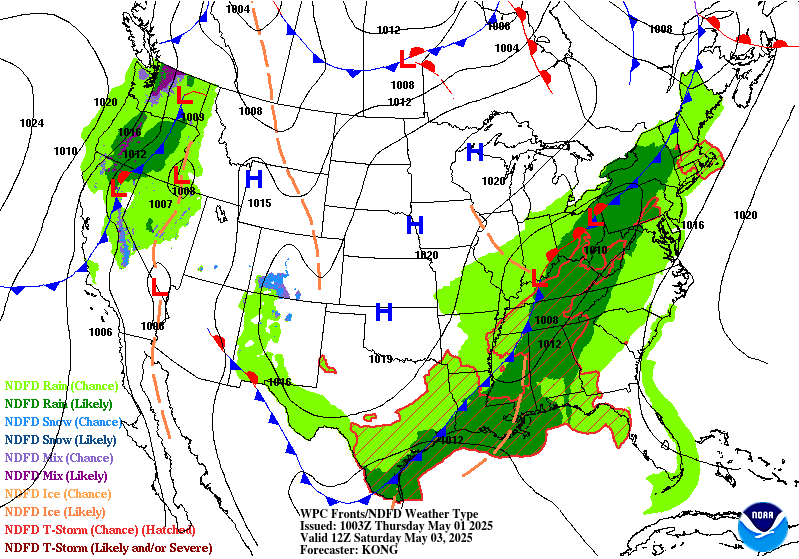
Excessive Rainfall Discussion
NWS Weather Prediction Center College Park MD
356 AM EDT Thu May 1 2025
Day 2
Valid 12Z Fri May 02 2025 - 12Z Sat May 03 2025
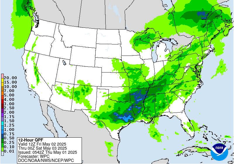
...THERE IS A SLIGHT RISK OF EXCESSIVE RAINFALL ACROSS FROM THE
SOUTHERN PLAINS INTO THE LOWER MISSISSIPPI VALLEY...
Steady progression of a cold front through the Southern Plains will
lead to textbook convergent pattern with an addition of a strong
upper diffluence signature within the bounds of the southern jet
proxy. High areal theta_E averages will denote the significant
instability pattern positioned ahead of the approaching cold front
leading to ample thermodynamic assistance for strong convective
cores and expected heavy rainfall. Recent CAMs have finally come
into view for the primary window of cell initiation with a
widespread convective pattern likely to extend from the Stockton
Plateau to points east within the I-10 corridor up through all of
Hill Country, especially over the I-35 section of south-central TX.
HREF blended mean QPF is over 2" now within a large area
encompassing the terrain focused across the Central portion of the
state. This had led to elevated neighborhood probs of >2" for the
12-00z time frame in the forecast running >70% over pretty much all
of the above region extending into portions of East TX. The East TX
corridor has become a newer development in terms of anticipated QPF
magnitude as the the CAMs and in some instances the global
deterministic are now catching on to the deep moisture advection
regime poking north out of the Western Gulf ahead of the front
arrival. Forecast soundings across the area between Houston up to
the latitude of Austin are now indicating MUCAPE or the order of
3500-5000 J/kg prior to any front arrival leading to significant
heavy cores to transpire due to cap breach from diurnal
destabilization initially, followed by more organized multi-cell
clusters as we move into the evening as the LLJ re-intensifies and
the cold front motions into the region.
Soundings also note a period of mean flow and upshear components
that would lead to potential backbuilding within the confines of
the front. Very strong ascent between 850-300mb is also noted
within multiple CAMs outputs, a testament to the favorability for
the setup to become more organized and providing a vast areal
expanse of heavy convection once the setup matures. PWATs between
1.6-1.9" with locally >2" are being forecast along and ahead of the
front as it moves into Central TX, a forecast that traditionally is
favored for greater flash flood prospects, especially over the
favored I-35 corridor between Austin to San Antonio where high
runoff capabilities are found due to soil type and limestone
foundations. Local totals between 3-6" are likely over the entire
stretch of Hill Country through East TX with the eastern most
extent even shifting into Western LA as the convective pattern
evolves and grows upscale entering into the adjacent Lower
Mississippi Valley. Houston metro is now in play for convective
impacts, especially as thunderstorms to the north provide outflow
generation that could send cold pools south towards the Gulf coast
with additional convective development along the edge of any
approaching cold pool.
The previous SLGT risk was relatively unchanged across Central TX.
Some expansion to the west was made into the Stockton Plateau where
initial cell formations will likely occur as the front arrives and
interacts with a formidable instability axis aligned over the
plateau itself. The SLGT was expanded southeast to cover the
Houston metro and points north where there is growing consensus on
convective impacts over and near the urban center. This is a high-
end SLGT over much of Central TX, especially Hill Country to the
I-35 corridor and points east. A risk upgrade is not out of the
question in subsequent updates given the environmental
favorability and flashy history of places expected to see the
greatest thunderstorm coverage/rates.
Kleebauer
Day 2 threat area:
www.wpc.ncep.noaa.gov/qpf/98epoints.txt
Excessive Rainfall Discussion
NWS Weather Prediction Center College Park MD
356 AM EDT Thu May 1 2025
Day 3
Valid 12Z Sat May 03 2025 - 12Z Sun May 04 2025
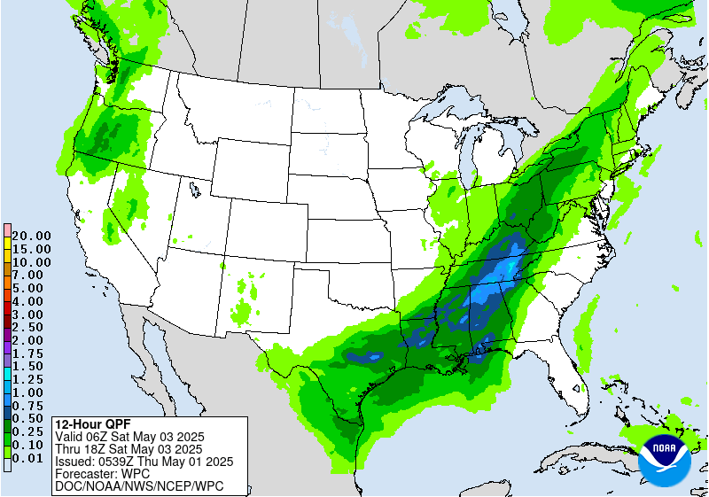
...THERE IS A MARGINAL RISK OF EXCESSIVE RAINFALL ACROSS MUCH OF
THE APPALACHIAN FRONT AS WELL AS PORTIONS OF THE GREAT BASIN...
...Appalachians...
An anomalous upper low center evolving over the Ohio Valley will
generate a strong diffluent signature downstream across the
Appalachians and points east with a significant moisture fetch
poleward from the Gulf, and eventual Atlantic Basin by the end of
the period. Organized convective activity will brew within the RER
of a strengthening upper jet core located over Ontario/Quebec as
the upper pattern becomes closed off to the west after 00z/Sun.
NAEFS PWAT anomalies between +1 and +2 deviations will offer a
suitable moisture rich environment conducive for stronger heavy
convective cores capable of locally enhanced rainfall prospects
within the confines of the great diffluent axis. As of this time,
this places the Appalachians Front from Northern GA up through PA
as the primary region of interest, however some elevated
instability notions are present within some of the recent
deterministic output. As of this time, a general 1-2" is forecast
within the above corridor with some heavier cells even possible as
far south as the Central Gulf Coast, but those are more aligned
within the decaying surface front that is progged to breakdown
before exiting the coastal plain. The area of focus will reside
within that broad ascent pattern enhanced by the evolving amplified
pattern to the east of the Mississippi with the complex terrain
providing a secondary element that would favor isolated flash flood
prospects. As a result, a broad MRGL risk extends from the
Southern Appalachians up through Northeast PA where the current
ensemble mean QPF is highest while also residing within the lower
FFG indices available in the Eastern CONUS.
...Great Basin...
Omega block pattern initiating over the CONUS will lead to yet
another amplified upper low generation across the Western CONUS
through D3. The threat for elevated convection in-of interior NV up
into Southeast OR have been forecast for several days with the
deterministic guidance basically "locked in" to the expected
evolution. Despite rainfall rates rather low grade compared to what
you normally find for flash flooding, this area has a notorious low
FFG bias that tends to accentuate the flash flood prospects in this
area of the CONUS. Recent ensemble means have been hovering between
0.75-1.25" of total QPF within the corridor extending from Reno to
points northeast with local maxima hovering up near 2" due to the
added effect of greater upper forcing thanks to the maturing closed
ULL reflection. This setup has been steady within the First Guess
Fields for the threat and really hasn't wavered much in the MRGL
risk output from the ML. Considering the factors above and a
pattern more favorable for these convective schemes across the
Great Basin, the previous MRGL risk inherited was maintained with a
small expansion northward into Southeast OR to highlight QPF trends
favoring better totals within those zones.
Kleebauer
Day 3 threat area:
www.wpc.ncep.noaa.gov/qpf/99epoints.txt
Extended Forecast Discussion
NWS Weather Prediction Center College Park MD
258 AM EDT Thu May 1 2025
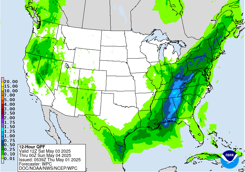
Confidence continues to increase with the forecast of an Ohio
Valley upper low and wavy East Coast front early next week,
supporting some areas of moderate to locally heavy rainfall. The
Days 4-5 Excessive Rainfall Outlooks covering early Sunday into
early Tuesday depict a Marginal Risk area over parts of the
northern Mid-Atlantic and Northeast where the persistent pattern
should direct the best moisture. Overall guidance signals suggest
Day 5/Sunday could have the higher rainfall totals over northern
Mid-Atlantic urban areas and thus requiring closer monitoring going
forward. Rainfall leading into and during the period will
initially be beneficial given the drought conditions over some
areas, but could trend less favorable with time if sufficiently
heavy on a localized basis. Additional rain should fall over the
Northeast through or beyond midweek, with decreasing confidence in
specifics given spread of the upper low and how northern stream
flow may interact.
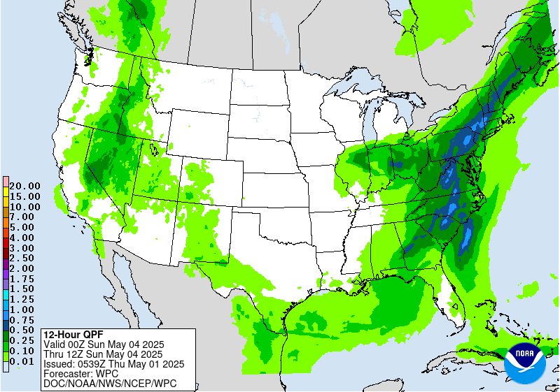
The upper low drifting across the Southwest/Four Corners and a
leading frontal boundary will initially produce a broad area of
rain and high elevation snow across the Interior West and Rockies
plus support increasing heavy rain potential over the southern half
of the Plains Monday onward. Guidance maintains some signal for
enhanced rainfall over the sensitive terrain over and near the
eastern half of New Mexico on Day 4/Sunday, so that ERO maintains
continuity with a Marginal Risk area. Continued eastward drift of
the upper low and leading wavy surface front by Day 5/Monday should
generate heavier rainfall over the southern High Plains at that
time. The best model clustering and first-guess guidance recommend
a Slight Risk area emphasizing northwestern Texas and far eastern
New Mexico with a little added extent to the north. The surrounding
Marginal Risk area extends somewhat northward along the eastern
slopes of the Rockies. Expect southern Plains heavy rain potential
to continue through midweek. During the Days 4-5 period there are
some indications for enhanced rainfall over other areas of the
Interior West/Rockies/High Plains but with not enough consensus to
suggest a risk area at this time.
The northern High Plains in particular will see well above normal
temperatures on Sunday, with some plus 15-25F anomalies for highs.
Temperatures will steadily moderate as this area of warmth migrates
eastward early next week. In contrast, the upper low tracking into
the Southwest will bring much cooler temperatures to the region.
Highs should be 10-20F below normal on Sunday-Monday, with some
record cold highs possible near the upper low's path. The Southwest
will slowly trend closer to normal after midweek. Persistent
clouds and rainfall should keep the southern High Plains below
normal for highs as well. The Northwest will see a warmer trend
next week, with some highs reaching 10-15F or so above normal. Over
the East, locations under and southwest of the Ohio Valley upper
low should see moderately below normal highs Sunday-Monday and then
some moderation. The Northeast will tend to see above normal lows.
This is the final forecast of my career. It has been an honor and
a source of great satisfaction to work in NOAA/NWS for the past 30+
years while witnessing the tremendous advances in weather
forecasting over that time. Now it's on to a retirement that
hopefully offers as much excitement as the weather. Best wishes to
all, and to all happy forecasting!
Rausch
Extended Forecast Discussion
NWS Weather Prediction Center College Park MD
258 AM EDT Thu May 1 2025
Confidence continues to increase with the forecast of an Ohio
Valley upper low and wavy East Coast front early next week,
supporting some areas of moderate to locally heavy rainfall. The
Days 4-5 Excessive Rainfall Outlooks covering early Sunday into
early Tuesday depict a Marginal Risk area over parts of the
northern Mid-Atlantic and Northeast where the persistent pattern
should direct the best moisture. Overall guidance signals suggest
Day 5/Sunday could have the higher rainfall totals over northern
Mid-Atlantic urban areas and thus requiring closer monitoring going
forward. Rainfall leading into and during the period will
initially be beneficial given the drought conditions over some
areas, but could trend less favorable with time if sufficiently
heavy on a localized basis. Additional rain should fall over the
Northeast through or beyond midweek, with decreasing confidence in
specifics given spread of the upper low and how northern stream
flow may interact.
The upper low drifting across the Southwest/Four Corners and a
leading frontal boundary will initially produce a broad area of
rain and high elevation snow across the Interior West and Rockies
plus support increasing heavy rain potential over the southern half
of the Plains Monday onward. Guidance maintains some signal for
enhanced rainfall over the sensitive terrain over and near the
eastern half of New Mexico on Day 4/Sunday, so that ERO maintains
continuity with a Marginal Risk area. Continued eastward drift of
the upper low and leading wavy surface front by Day 5/Monday should
generate heavier rainfall over the southern High Plains at that
time. The best model clustering and first-guess guidance recommend
a Slight Risk area emphasizing northwestern Texas and far eastern
New Mexico with a little added extent to the north. The surrounding
Marginal Risk area extends somewhat northward along the eastern
slopes of the Rockies. Expect southern Plains heavy rain potential
to continue through midweek. During the Days 4-5 period there are
some indications for enhanced rainfall over other areas of the
Interior West/Rockies/High Plains but with not enough consensus to
suggest a risk area at this time.
The northern High Plains in particular will see well above normal
temperatures on Sunday, with some plus 15-25F anomalies for highs.
Temperatures will steadily moderate as this area of warmth migrates
eastward early next week. In contrast, the upper low tracking into
the Southwest will bring much cooler temperatures to the region.
Highs should be 10-20F below normal on Sunday-Monday, with some
record cold highs possible near the upper low's path. The Southwest
will slowly trend closer to normal after midweek. Persistent
clouds and rainfall should keep the southern High Plains below
normal for highs as well. The Northwest will see a warmer trend
next week, with some highs reaching 10-15F or so above normal. Over
the East, locations under and southwest of the Ohio Valley upper
low should see moderately below normal highs Sunday-Monday and then
some moderation. The Northeast will tend to see above normal lows.
This is the final forecast of my career. It has been an honor and
a source of great satisfaction to work in NOAA/NWS for the past 30+
years while witnessing the tremendous advances in weather
forecasting over that time. Now it's on to a retirement that
hopefully offers as much excitement as the weather. Best wishes to
all, and to all happy forecasting!
Rausch


