Excessive Rainfall Discussion
NWS Weather Prediction Center College Park MD
1151 AM EDT Fri May 2 2025
Day 1
Valid 16Z Fri May 02 2025 - 12Z Sat May 03 2025
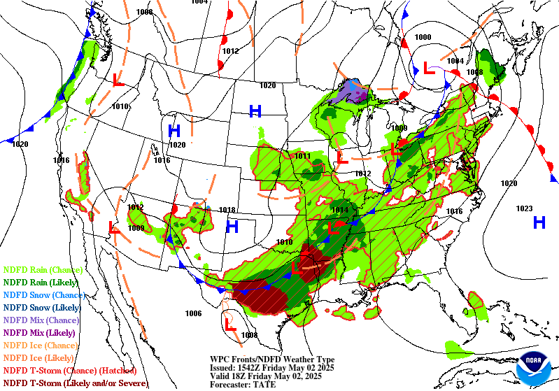
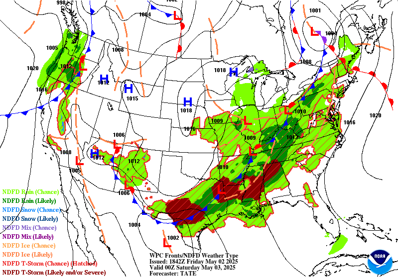
...THERE IS A SLIGHT RISK OF EXCESSIVE RAINFALL OVER PORTIONS OF
THE SOUTHERN PLAINS, LOWER MISSISSIPPI, AND TENNESSEE VALLEYS...
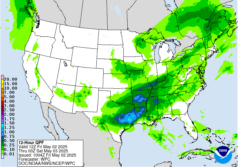
...16Z Update...
The most notable change with the midday update was to expand the
Slight eastward to include more of Tennessee and Alabama. The
Nashville, Chattanooga, and Birmingham metros are now upgraded to a
Slight-risk, albeit a lower-end, lower confidence one.
Numerous areas of thunderstorms are expected to develop this
afternoon in response to growing instability and Gulf moisture
across the southern US ahead of a sweeping cold front. These storms
are forecast in the guidance to develop into several clusters. The
westernmost one over Texas will have the greatest potential to
cause flash flooding, as the southward push of the front is most
likely to stall out there as compared with areas further east.
Fortunately, once the current MCS over north Texas pushes further
south in response to new thunderstorm development this afternoon,
that should be the end of the heavy rain threat in that area for a
couple days. The best chance for training storms will generally be
from Austin east to roughly the Louisiana border, which has been
consistent in the guidance for at least the last 24 hours. Only a
small portion of this area was hit with heavy rain yesterday, and
with individual cells moving along with some southward component to
their motion, think the threat doesn't quite rise to the Moderate
Risk level, so the area remains in a Slight Risk.
Atmospheric ingredients remain favorable for the development of
flash flooding, with afternoon MUCAPE values expected to approach
3,000 J/kg across the Mid-South and PWATs in most areas between
1.25 and 1.5 inches. This is about 1-1.5 sigma above climatology
for this area. The PWATs will remain favorable as a 20-30 kt
southwesterly flow at 850 advects more Gulf moisture into the
storms that is lost from rainfall.
Thunderstorms will be a bit more progressive further east into
northern Louisiana and southern Arkansas, but that area has been
hard-hit with heavy rains over the past week, and soil moisture
levels remain quite high. Thus, with antecedent conditions more
favorable, the higher end Slight remains in effect for this area
with few changes.
Further east, as mentioned above the Slight Risk was expanded east
to include more of Alabama and Tennessee. The combination of urban
concerns in Nashville, Chattanooga, and Birmingham, some potential
for pre-line convection developing over those metros, and at or
above normal soil moisture levels in those areas favored the
upgrade to a lower-end Slight. The fast-moving progressive nature
of all of the storms, especially any line segments, does mitigate
the flash flood potential.
Finally, further up the front into the upper Ohio Valley and New
York, the storms will be moving even more quickly, with less Gulf
moisture to work with, but recent heavy rains in this area have
made antecedent soil moisture conditions very favorable for the
development of additional flash flooding, so the Marginal Risk area
was expanded northeastward, though the severe threat in this area
looks to be much greater.
No changes were made to the Marginal Risk across portions of
central and western New Mexico with few changes there in the
guidance.
Wegman
...Previous Discussion...
Another round of thunderstorms is expected to develop along and
ahead of a southward moving cold front on Friday...with guidance
still focusing the greatest chances for excessive rainfall from
portions of the Mid-South into the Southern Plains Friday into
Friday night as weak waves propagate northeastward along the front.
Southerly low level flow will draw Gulf moisture northward...helping
increase precipitable water values ahead of the front to 1.5 to
1.75 inches at the time of the peak heating in a stripe from Texas
into southern Arkansas. Forecast soundings depict an atmosphere
supportive of rainfall rates exceeding 2 inches per hour. As
mentioned previously...the potential for a prolonged period of
training is fairly minimal so a Slight Risk still seems to cover
the potential. 00Z HREF neighborhood probabilities of 1-hour QPF
exceeding 2 inches were over 30 percent in parts of southeast TX
with lower probabilities extending into parts of Arkansas.
A Marginal Risk area surrounding the Slight Risk area extends as
far northeastward as parts of the Great Lakes. Precipitable water
values were generally at or below 1.25 inches ahead of the
advancing cold front but guidance still showed enough instability
to support showers and thunderstorms over an area that was still
had lingering hydrologic sensitivity following recent heavy
rainfall. In addition...the area will be underneath a right
entrance region of an upper level jet stream aiding upper level
support during the afternoon.
Farther west...there is also a Marginal risk of excessive rainfall
from late day and evening convection over the terrain of New
Mexico. The QPF is fairly modest but even modest rainfall rates
could result in isolated problems with run off...especially if the
rain falls on recent burn scars.
Bann
Day 1 threat area:
www.wpc.ncep.noaa.gov/qpf/94epoints.txt
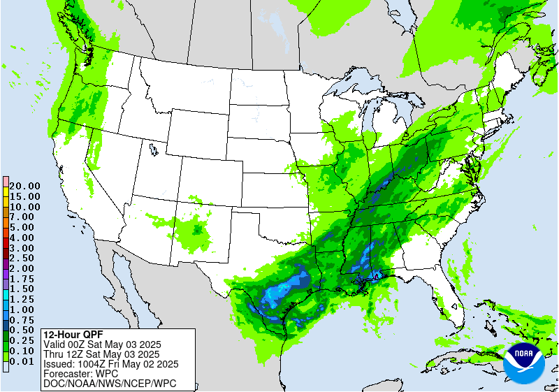
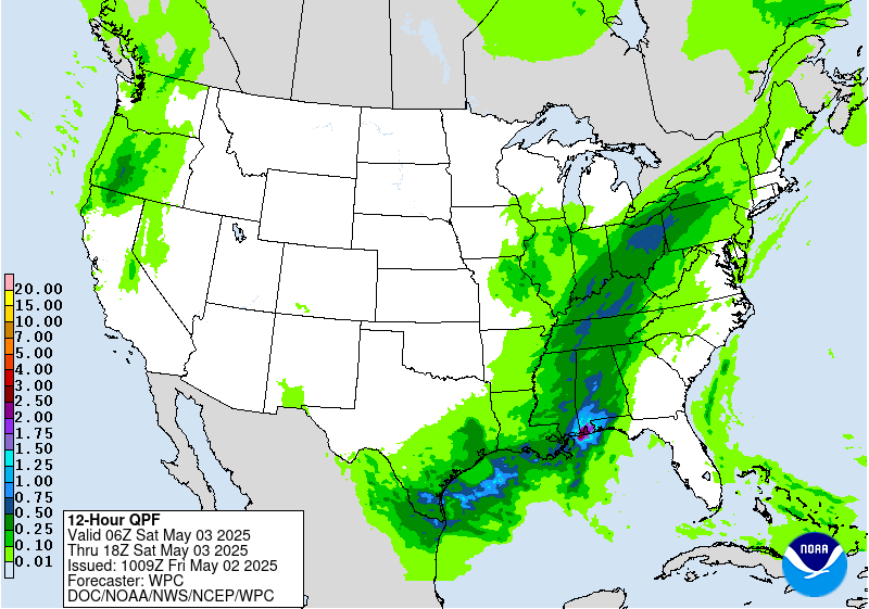
Excessive Rainfall Discussion
NWS Weather Prediction Center College Park MD
1151 AM EDT Fri May 2 2025
Day 2
Valid 12Z Sat May 03 2025 - 12Z Sun May 04 2025
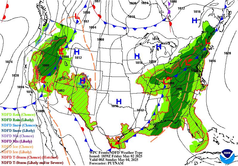
....THERE IS A MARGINAL RISK OF EXCESSIVE RAINFALL FROM THE GULF
COAST REGION INTO PARTS OF THE EASTERN GREAT LAKES...
The focus for excessive rainfall will shift eastward as a closed
mid-level circulation center takes shape over the nation's mid-
section. The mid- and upper-level flow backs with time from the
Gulf coast northward across parts of the Tennessee and Ohio
Valleys. Initially...this allows deeper moisture to stream
northward. But it also results in the surface/low level front to
move eastward more quickly later in the period...with generally a
low-end risk of flooding from the Gulf coast northward. The 02/00Z
suite of numerical guidance hint that there could be some 1 inch to
perhaps 2 inch amounts where frontogenetic forcing aligns
favorably in between the Gulf and the Ohio Valley...but the signal
for excessive rainfall showed little run to run / model to model
consistency.
There is also a Marginal Risk of excessive rainfall over far
southern portion of Texas...where the southern end of the cold has
stalled its southward progression and return flow of Gulf moisture
has begun. Several of the High Res ensemble highlight this area
with QPF in the upper percentiles although the consensus is less
than unanimous in amounts or placement. With soundings showing
warm cloud processes through a deep layer and the CAPE profile is
tall and skinny...introduced a Marginal risk here.
Bann
Day 2 threat area:
www.wpc.ncep.noaa.gov/qpf/98epoints.txt
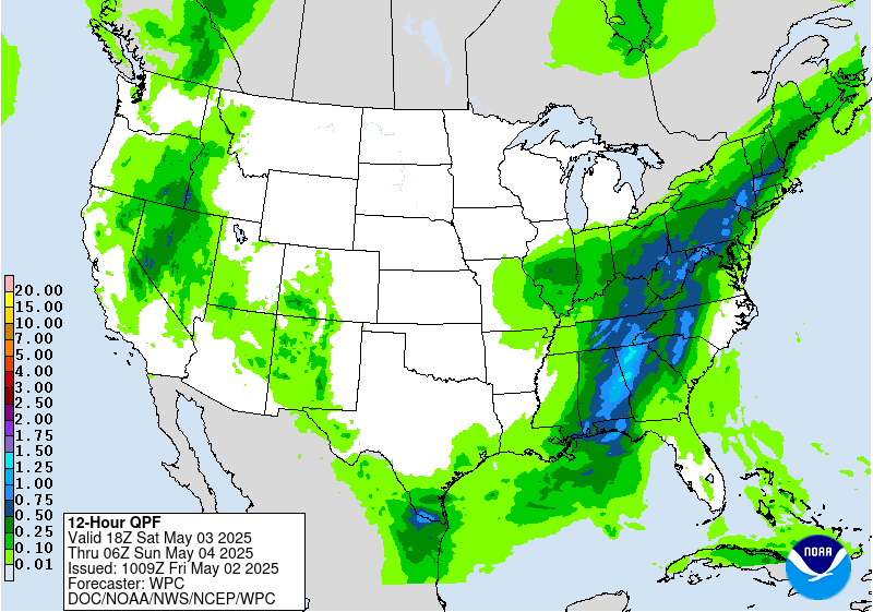
Excessive Rainfall Discussion
NWS Weather Prediction Center College Park MD
1151 AM EDT Fri May 2 2025
Day 3
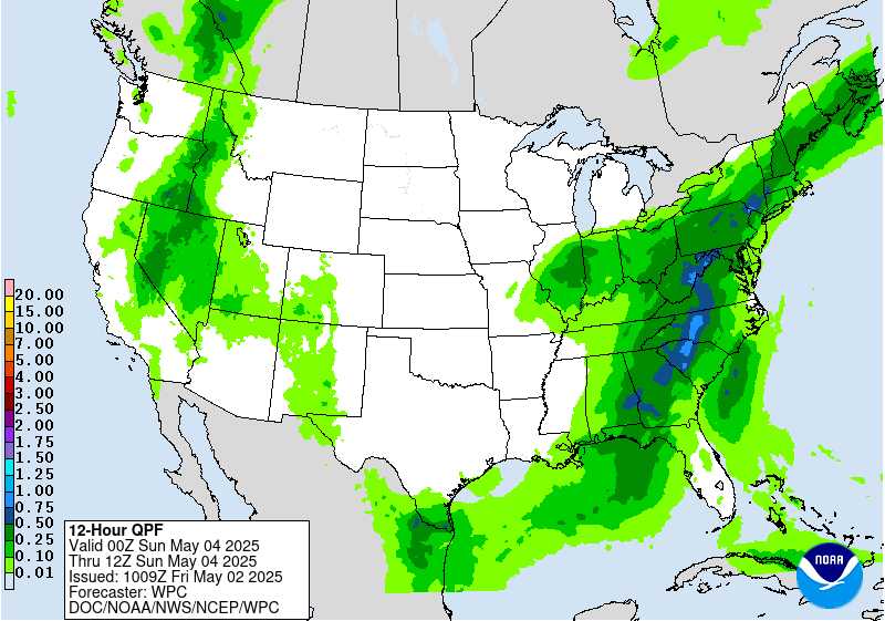
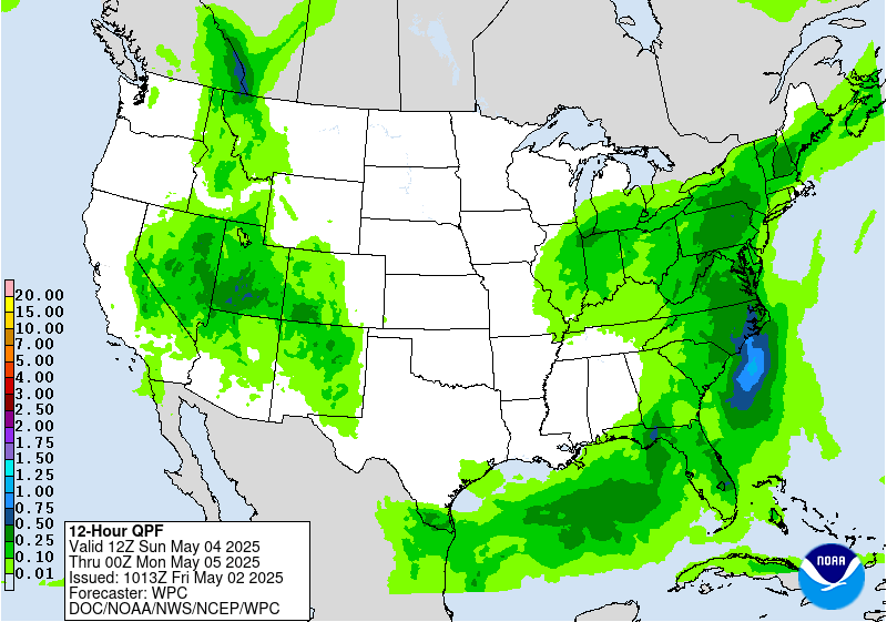
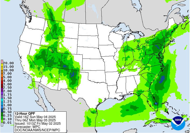
Valid 12Z Sun May 04 2025 - 12Z Mon May 05 2025
...THERE IS A MARGINAL RISK OF EXCESSIVE RAINFALL OVER PARTS OF THE
EASTERN UNITED STATES AND SOUTHERN ROCKIES ...
The risk of excessive rainfall persists across parts of the Mid-
Atlantic and Southeast US as a broad upper trough continues to make
its way eastward on Day 3. Deepest moisture of 1.25 to 1.5 inches
will be eventually be shunted off-shore late in the period. Until
then...isolated downpours are possible with spaghetti plots of
2 and 3-inches of rain in 24 hours mainly being produced by models
with the ARW core...but enough members from the NMM core and from
the GEFS to warrant a Marginal.
There is also a Marginal Risk area over parts of New Mexico again
as moisture continue to spread northward and westward from the
Gulf. After 00Z...the flow aloft between the westerly subtropical
jet and a jet streak and low- and mid-levels become increasingly
diffluent with height falls beginning ahead of an approaching
closed low from the west. This...along with moisture and a low
level boundary already in place...should support late day and
evening storms that may produce locally heavy rainfall rates.
Bann
Day 3 threat area:
www.wpc.ncep.noaa.gov/qpf/99epoints.txt


