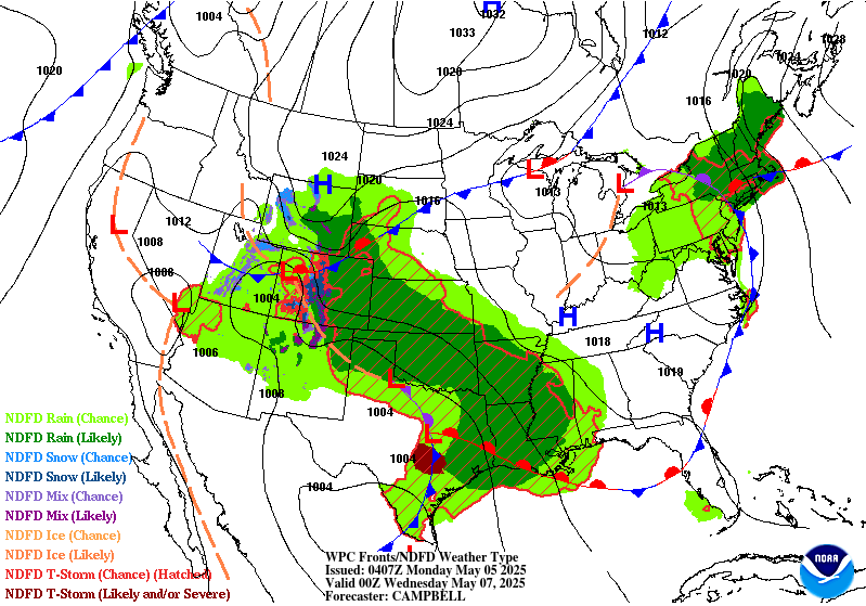
Extended Forecast Discussion
NWS Weather Prediction Center College Park MD
306 PM EDT Sun May 4 2025
Valid 12Z Wed May 07 2025 - 12Z Sun May 11 2025
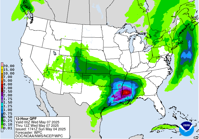
...Mid to late week heavy rainfall potential for the central Gulf
Coast into the Southeast...
...Overview...
A blocky pattern in the short range should finally begin to break
down by Wednesday as a pair of upper lows over the East and West
weaken and shift east. A stationary or slow moving frontal boundary
draped across the Southeast may continue to support heavy rainfall
across the region, and especially along the Gulf Coast. A
shortwave dropping in from east-central Canada may briefly cut off
another upper low over the Northeast on Friday, while the western
low shifts east and eventually settles over the Southeast next
weekend. This may continue the threat for showers and storms across
the Southeast through much of the period. Upper ridging over the
West Coast will build east into the Rockies/Central U.S. as a
Pacific trough nears the West Coast next Sunday.
...Guidance/Predictability Assessment...
While model guidance agrees in principle on the larger scale
features described above, uncertainty in the details still produce
sensible weather differences. Models show the cutoff upper low
moving slowly from the southwestern to south-central U.S. as the
week progresses. By Thursday-Friday model differences with this
feature include the new 12Z GFS farther south and west with energy
at the low's base near Texas and the Lower Mississippi Valley,
pushing the front offshore into the Gulf for less rain onshore in
the central Gulf Coast area but more QPF filtering into much of
Texas. Did not prefer this 12Z GFS solution as it was against
consensus.
Meanwhile farther north, the initially closed low over the
Northeast should quickly track northeast as additional energy dives
in from Canada. This second round of troughing shows a lot more
spread in placement into later week as it may form a closed low.
Through the 00/06Z model cycle, on Saturday for example the 00Z GFS
and ECMWF were reasonably well aligned with the upper and surface
low position and generally in line with the ensemble means, so
generally favored that cluster, which also jived well with
continuity. The 06Z GFS was farther southwest and the 00Z CMC was
much farther northeast. Many of the AI/ML models were farther
northeast like the CMC so did not want to totally rule that out.
However, now the newer 12Z model guidance is tending to favor
slower/farther southwest positions for that feature. So this
forecast continues to be in flux and further changes may be needed.
In the West, upper ridging should build in the Great Basin and
Rockies behind the upper low. By late week into the weekend greater
model differences start to occur to its west with troughing and a
possible embedded upper low in the eastern Pacific. The 00Z CMC
looks like an outlier bringing a closed low into British Columbia
and the Northwest. 12Z models continue to show some spread in the
trough's timing moving toward the Northwest.
The WPC forecast used a multi-model blend of deterministic
guidance favoring the ECMWF and GFS early in the period. Used the
ensemble means and increased their proportion to over half by Days
6-7 as model spread increased.
...Weather/Hazards Highlights...
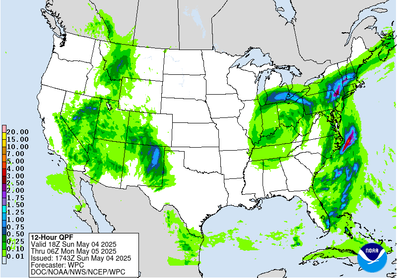
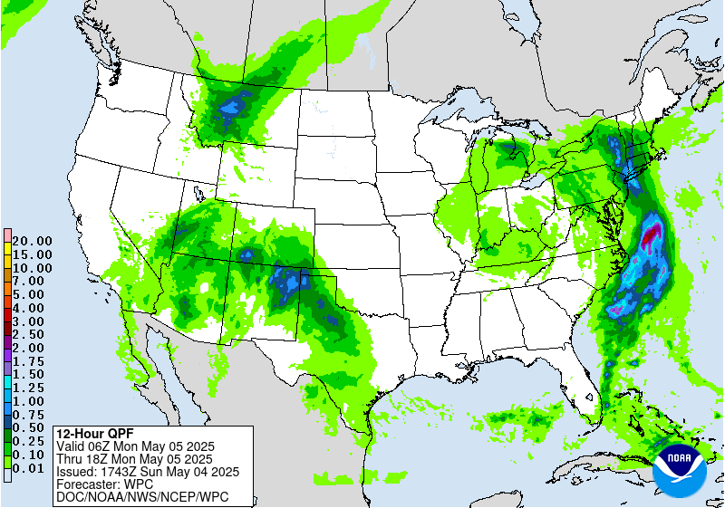
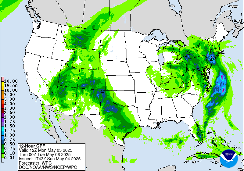
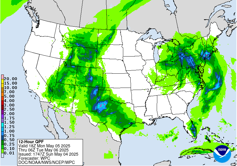
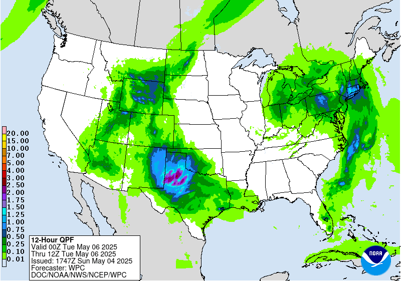
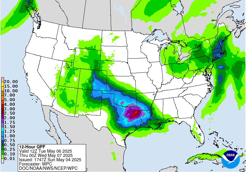
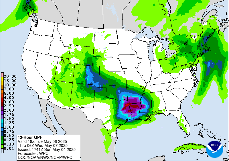
By Wednesday, the start of the period, the heaviest rains are
likely to focus near the central Gulf Coast pooling along a frontal
boundary. Heavy rain rates are likely along the cusp of the
instability gradient and training storms are possible generally in
southern Louisiana and vicinity. However, there are some competing
factors for flooding to be too widespread Wednesday, including
model spread with some focusing the front and thus the rainfall
offshore. The farther south axis of heaviest rain compared to the
short range puts the highest QPF atop drier antecedent conditions,
along with higher flash flood guidance in swamplands. Thus
maintained the Slight Risk across much of the Lower Mississippi
Valley rather than any upgrades at this time and will continue to
monitor trends. Urban areas could still be vulnerable to flash
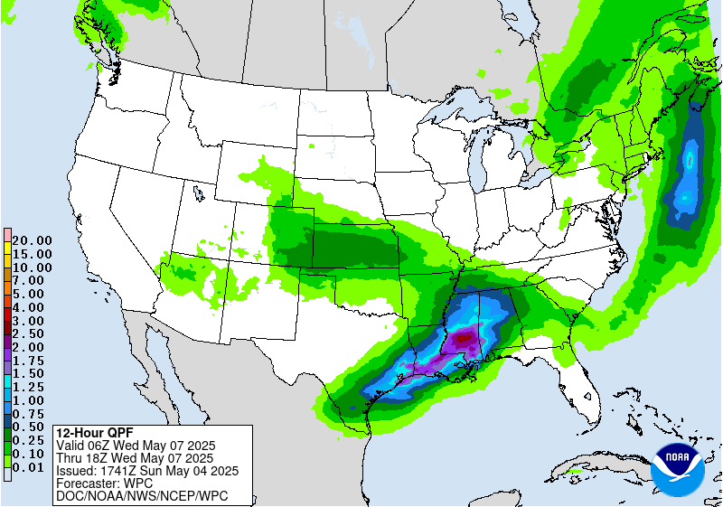
flooding. Heavy rain could persist into Thursday along the central
Gulf Coast and into parts of the Southeast. Again, model spread and
higher flash flood guidance limits flooding potential for now and
will maintain a Marginal Risk for these areas on Day 5/Thursday.
Rain and thunderstorms are likely to persist across the Southeast
late week into the weekend.
Meanwhile farther west and north, precipitation including higher
elevation snow could continue into Wednesday for the south-central
Rockies. Areas of rain are also likely across the central Plains to
Middle Mississippi Valley Wednesday-Thursday and lingering into
Friday in the Lower Mississippi Valley. Areas of rain are also
possible in the northeastern U.S. at times later this week into the
weekend. On Wednesday, some wrapback moisture and instability on
the backside of the associated surface low could allow for modest
rain in Interior Northeast, but with several model and QPF cycles
showing this rain staying well under an inch, removed the Marginal
Risk as any flooding chances should be below 5 percent.
The upper low over the Southwest early in the period will result
in lingering below normal temperatures for the Southwest and south-
central Plains where daytime highs could be 10-20 degrees below
normal. This should moderate with time but may still remain
modestly below normal into late week for the southern Plains. Upper
ridging building over the West as the upper low shifts east will
allow for expanding coverage of above normal temperatures there as
the week progresses, including 100 degree temperatures in the
Desert Southwest. Above average temperatures will stretch into the
northern tier as well, with highs reaching the 70s and 80s in the
northern Plains to Upper Midwest.
Tate/Santorelli
Additional 3-7 Day Hazard information can be found on the WPC
medium range hazards outlook chart at:
https://www.wpc.ncep.noaa.gov/threats/threats.php
WPC medium range 500mb heights, surface systems, weather grids,
quantitative precipitation forecast (QPF), excessive rainfall
outlook (ERO), winter weather outlook (WWO) probabilities, heat
indices, and Key Messages can be accessed from:
https://www.wpc.ncep.noaa.gov/medr/5dayfcst500_wbg.gif
https://www.wpc.ncep.noaa.gov/medr/5dayfcst_wbg_conus.gif
https://www.wpc.ncep.noaa.gov/5km_grids/5km_gridsbody.html
https://www.wpc.ncep.noaa.gov/qpf/day4-7.shtml
https://www.wpc.ncep.noaa.gov/#page=ero
https://www.wpc.ncep.noaa.gov/wwd/pwpf_d47/pwpf_medr.php?day=4
https://www.wpc.ncep.noaa.gov/heat_index.shtml
https://www.wpc.ncep.noaa.gov/#page=ovw


