Excessive Rainfall Discussion
NWS Weather Prediction Center College Park MD
400 PM EDT Fri May 2 2025
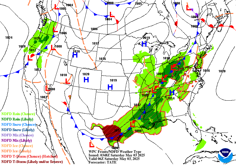
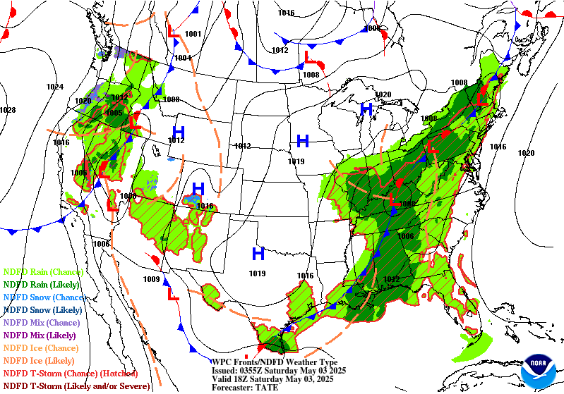
Day 1
Valid 16Z Fri May 02 2025 - 12Z Sat May 03 2025
...THERE IS A SLIGHT RISK OF EXCESSIVE RAINFALL OVER PORTIONS OF
THE SOUTHERN PLAINS, LOWER MISSISSIPPI, AND TENNESSEE VALLEYS...
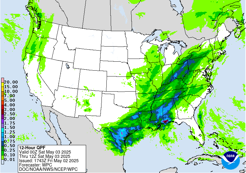
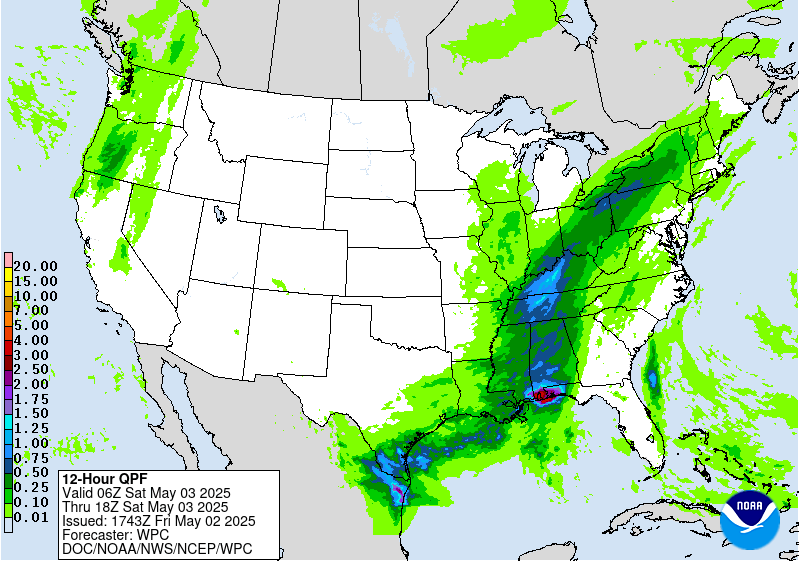
...16Z Update...
The most notable change with the midday update was to expand the
Slight eastward to include more of Tennessee and Alabama. The
Nashville, Chattanooga, and Birmingham metros are now upgraded to a
Slight-risk, albeit a lower-end, lower confidence one.
Numerous areas of thunderstorms are expected to develop this
afternoon in response to growing instability and Gulf moisture
across the southern US ahead of a sweeping cold front. These storms
are forecast in the guidance to develop into several clusters. The
westernmost one over Texas will have the greatest potential to
cause flash flooding, as the southward push of the front is most
likely to stall out there as compared with areas further east.
Fortunately, once the current MCS over north Texas pushes further
south in response to new thunderstorm development this afternoon,
that should be the end of the heavy rain threat in that area for a
couple days. The best chance for training storms will generally be
from Austin east to roughly the Louisiana border, which has been
consistent in the guidance for at least the last 24 hours. Only a
small portion of this area was hit with heavy rain yesterday, and
with individual cells moving along with some southward component to
their motion, think the threat doesn't quite rise to the Moderate
Risk level, so the area remains in a Slight Risk.
Atmospheric ingredients remain favorable for the development of
flash flooding, with afternoon MUCAPE values expected to approach
3,000 J/kg across the Mid-South and PWATs in most areas between
1.25 and 1.5 inches. This is about 1-1.5 sigma above climatology
for this area. The PWATs will remain favorable as a 20-30 kt
southwesterly flow at 850 advects more Gulf moisture into the
storms that is lost from rainfall.
Thunderstorms will be a bit more progressive further east into
northern Louisiana and southern Arkansas, but that area has been
hard-hit with heavy rains over the past week, and soil moisture
levels remain quite high. Thus, with antecedent conditions more
favorable, the higher end Slight remains in effect for this area
with few changes.
Further east, as mentioned above the Slight Risk was expanded east
to include more of Alabama and Tennessee. The combination of urban
concerns in Nashville, Chattanooga, and Birmingham, some potential
for pre-line convection developing over those metros, and at or
above normal soil moisture levels in those areas favored the
upgrade to a lower-end Slight. The fast-moving progressive nature
of all of the storms, especially any line segments, does mitigate
the flash flood potential.
Finally, further up the front into the upper Ohio Valley and New
York, the storms will be moving even more quickly, with less Gulf
moisture to work with, but recent heavy rains in this area have
made antecedent soil moisture conditions very favorable for the
development of additional flash flooding, so the Marginal Risk area
was expanded northeastward, though the severe threat in this area
looks to be much greater.
No changes were made to the Marginal Risk across portions of
central and western New Mexico with few changes there in the
guidance.
Wegman
...Previous Discussion...
Another round of thunderstorms is expected to develop along and
ahead of a southward moving cold front on Friday...with guidance
still focusing the greatest chances for excessive rainfall from
portions of the Mid-South into the Southern Plains Friday into
Friday night as weak waves propagate northeastward along the front.
Southerly low level flow will draw Gulf moisture northward...helping
increase precipitable water values ahead of the front to 1.5 to
1.75 inches at the time of the peak heating in a stripe from Texas
into southern Arkansas. Forecast soundings depict an atmosphere
supportive of rainfall rates exceeding 2 inches per hour. As
mentioned previously...the potential for a prolonged period of
training is fairly minimal so a Slight Risk still seems to cover
the potential. 00Z HREF neighborhood probabilities of 1-hour QPF
exceeding 2 inches were over 30 percent in parts of southeast TX
with lower probabilities extending into parts of Arkansas.
A Marginal Risk area surrounding the Slight Risk area extends as
far northeastward as parts of the Great Lakes. Precipitable water
values were generally at or below 1.25 inches ahead of the
advancing cold front but guidance still showed enough instability
to support showers and thunderstorms over an area that was still
had lingering hydrologic sensitivity following recent heavy
rainfall. In addition...the area will be underneath a right
entrance region of an upper level jet stream aiding upper level
support during the afternoon.
Farther west...there is also a Marginal risk of excessive rainfall
from late day and evening convection over the terrain of New
Mexico. The QPF is fairly modest but even modest rainfall rates
could result in isolated problems with run off...especially if the
rain falls on recent burn scars.
Bann
Day 1 threat area:
www.wpc.ncep.noaa.gov/qpf/94epoints.txt
Excessive Rainfall Discussion
NWS Weather Prediction Center College Park MD
400 PM EDT Fri May 2 2025
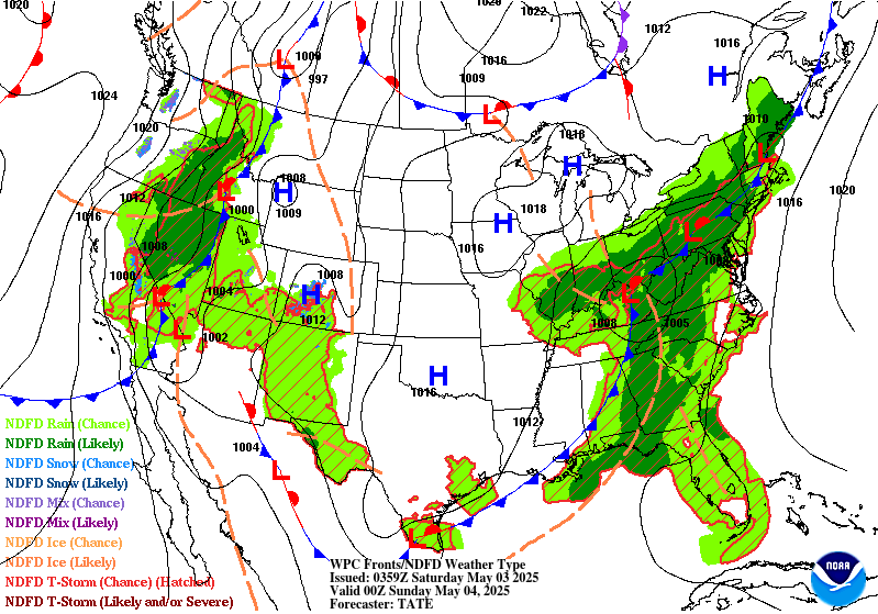
Day 2
Valid 12Z Sat May 03 2025 - 12Z Sun May 04 2025
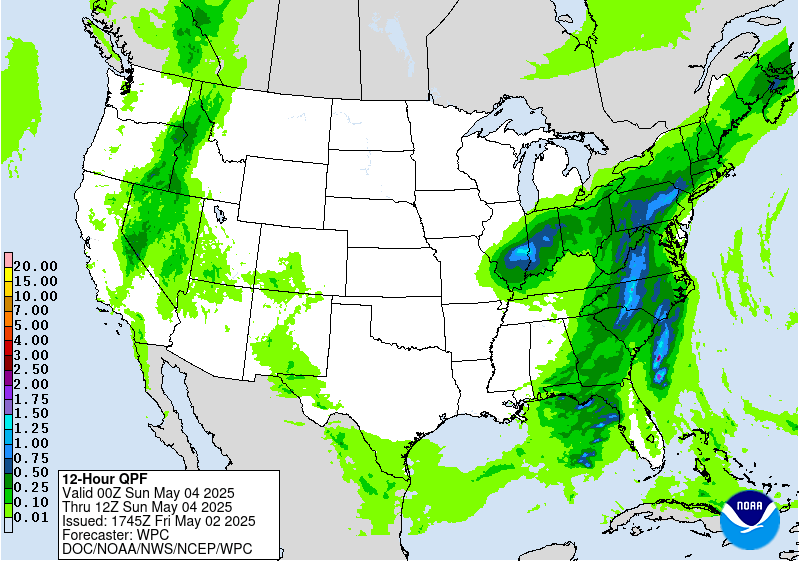
....THERE IS A MARGINAL RISK OF EXCESSIVE RAINFALL FROM THE GULF
COAST REGION INTO PARTS OF THE NORTHEAST, EXTREME DEEP SOUTH TEXAS,
AND THE SACRAMENTO MOUNTAINS OF NEW MEXICO...
...20Z Update...
The Marginal Risk across portions of the East Coast was expanded
east to include portions of the I-95 corridor through DC and
Baltimore, the Piedmont of the Carolinas, and expanded west into
east central Illinois. A new Marginal Risk was issued for the
Sacramento Mountains of New Mexico.
Due to uncertainties with potential training storms up the Blue
Ridge of VA into PA, including impacts into the DC and Baltimore
metros, a low-end Marginal expanded to include that portion of the
I-95 corridor with this update. Most of the guidance suggests any
heavier rains and training storms will be west of the metro, and
the ongoing severe drought will mitigate most impacts, but an
isolated flood can't be ruled out should training storms move over
those cities. Given some instability expected into southern New
England, the Marginal was also expanded into western MA and CT on
the assumption that northeastward moving storms may persist longer
into New England. Wraparound rain around the north side of a cutoff
low over Illinois has resulted in a decently well agreed upon
maximum of rainfall into east central Illinois, so the Marginal was
expanded west for that as well.
The Marginal in extreme deep south Texas was trimmed from the north
to exclude areas with very high FFGs. It appears increasingly
likely that the storms impacting that area, if they train, will be
south of the border, but some potential remains into McAllen and
Brownsville for training storms, so the Marginal was left in place
for those urban centers.
In coordination with ABQ/Albuquerque WFO, a Marginal was introduced
for the Sacramento Mountains for the potential for nearly
stationary storms tied to the terrain impacting old burn scar areas
near Ruidoso, NM.
Wegman
...Previous Discussion...
The focus for excessive rainfall will shift eastward as a closed
mid-level circulation center takes shape over the nation's mid-
section. The mid- and upper-level flow backs with time from the
Gulf coast northward across parts of the Tennessee and Ohio
Valleys. Initially...this allows deeper moisture to stream
northward. But it also results in the surface/low level front to
move eastward more quickly later in the period...with generally a
low-end risk of flooding from the Gulf coast northward. The 02/00Z
suite of numerical guidance hint that there could be some 1 inch to
perhaps 2 inch amounts where frontogenetic forcing aligns
favorably in between the Gulf and the Ohio Valley...but the signal
for excessive rainfall showed little run to run / model to model
consistency.
There is also a Marginal Risk of excessive rainfall over far
southern portion of Texas...where the southern end of the cold has
stalled its southward progression and return flow of Gulf moisture
has begun. Several of the High Res ensemble highlight this area
with QPF in the upper percentiles although the consensus is less
than unanimous in amounts or placement. With soundings showing
warm cloud processes through a deep layer and the CAPE profile is
tall and skinny...introduced a Marginal risk here.
Bann
Day 2 threat area:
www.wpc.ncep.noaa.gov/qpf/98epoints.txt
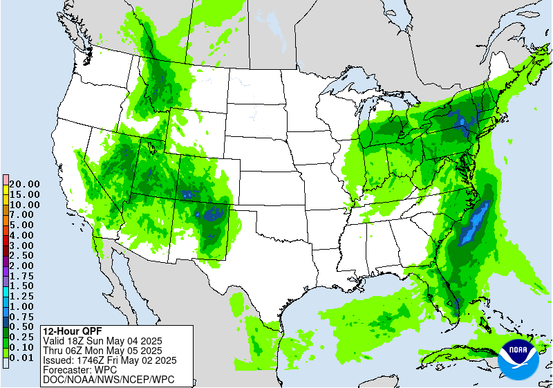
Excessive Rainfall Discussion
NWS Weather Prediction Center College Park MD
400 PM EDT Fri May 2 2025
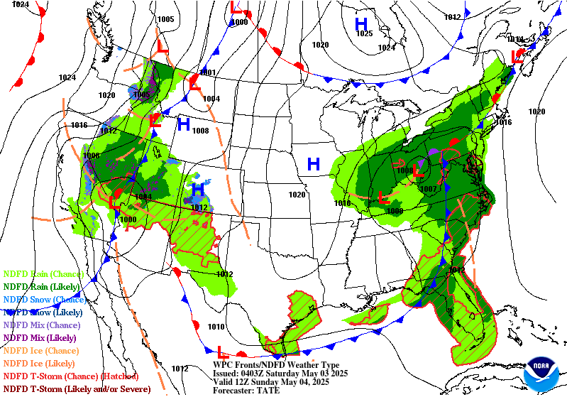
Day 3
Valid 12Z Sun May 04 2025 - 12Z Mon May 05 2025
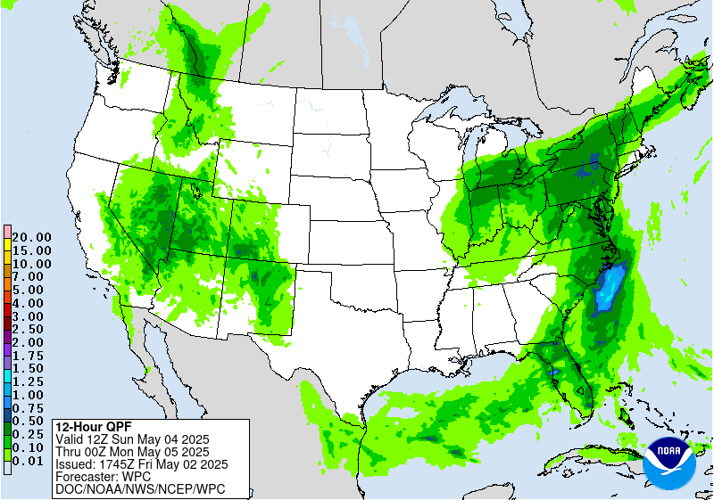
...THERE IS A MARGINAL RISK OF EXCESSIVE RAINFALL OVER PARTS OF THE
EASTERN UNITED STATES AND SOUTHERN ROCKIES ...
...20Z Update...
The Marginal Risk across the East Coast was expanded greatly to
include much of the Northeast, Mid-Atlantic and coastal Carolinas,
with the other Marginal expanded well west to include portions of
southwest Colorado, southern Utah, and eastern Nevada with this
update.
The Marginal across the east will be for continue training showers
and storms into New England, with a maximum of rainfall likely near
the Catskills and Poconos of NY and PA, respectively. Rates should
remain low enough with some breaks in the rain that amounts remain
within Marginal thresholds, but should the Day 2/Saturday rainfall
overperform in this area or if the forecast rain comes up for
Sunday, then a targeted Slight risk may be needed. Occasional
storms with MUCAPE instability values between 500 and 1,000 J/kg
are more likely to impact more of the I-95 corridor from Raleigh,
NC through NYC. Drought conditions are very likely to temper all
but the most persistent rains, but given the sensitivities in the
urban corridor, the Marginal was expanded to account for potential
training storms.
The Marginal Risk out west was expanded with a deep but slow moving
upper level low and trough moving across the 4-corners region,
drawing some Gulf moisture well northwest and into the area, where
terrain will cause localized upslope. Rocky terrain will also favor
rapid development of flash flooding in the local areas where the
rain is most persistent. The highest elevations will see mostly
snow from this event, but most of the area should see rain, which
is the rationale for the expansion of the Marginal. The San Juans
will have some of the heaviest precipitation, which should lower
snow levels locally enough to carve that area out of the Marginal
with this update.
Wegman
...Previous Discussion...
The risk of excessive rainfall persists across parts of the Mid-
Atlantic and Southeast US as a broad upper trough continues to make
its way eastward on Day 3. Deepest moisture of 1.25 to 1.5 inches
will be eventually be shunted off-shore late in the period. Until
then...isolated downpours are possible with spaghetti plots of
2 and 3-inches of rain in 24 hours mainly being produced by models
with the ARW core...but enough members from the NMM core and from
the GEFS to warrant a Marginal.
There is also a Marginal Risk area over parts of New Mexico again
as moisture continue to spread northward and westward from the
Gulf. After 00Z...the flow aloft between the westerly subtropical
jet and a jet streak and low- and mid-levels become increasingly
diffluent with height falls beginning ahead of an approaching
closed low from the west. This...along with moisture and a low
level boundary already in place...should support late day and
evening storms that may produce locally heavy rainfall rates.
Bann
Day 3 threat area:
www.wpc.ncep.noaa.gov/qpf/99epoints.txt
Extended Forecast Discussion
NWS Weather Prediction Center College Park MD
301 PM EDT Fri May 2 2025
Early next week, two occluded frontal systems are expected to
bring moderate to locally heavy rainfall to portions of the West
and East. In the West, anomalous moisture accompanying the upper
low will support heightened precipitation from the Great Basin to
the Central and Southern Rockies and Plains. By Monday, the system
will become stationary over the Plains, allowing for anomalous
moisture to continuously pool near a boundary in the vicinity.
Several rounds of moisture-laden thunderstorms are likely to
result in a multi-day heavy rainfall event across the Central and
Southern Plains and into the lower Mississippi Valley Monday
through Wednesday. Portions of the Plains states will be especially
vulnerable to heavy rain/flooding due to recent heavy rains and
saturated soils. This activity is highlighted in the Day 4-5
Excessive Rainfall Outlooks (EROs) with a slight risk area
highlighted across the Texas and Oklahoma panhandles on Monday. For
Tuesday, a growing signal with high confidence of widespread 2-5"+
rainfall amounts across portions of the ArkLaTex and Lower
Mississippi Valley warranted a broader expansion of the slight risk
area. Higher end probabilities of excessive rainfall are focused
across northeast Texas, extreme southeast Oklahoma, southern
Arkansas, west central Mississippi and northern Louisiana. Given
relatively good spatial and temporal model agreement and amounts
trending higher, would not be surprised to see an embedded upgrade
to a moderate risk in future forecast updates.
Under the eastern upper low, the frontal system will very slowly
push eastward early next week, resulting in a stream of onshore
moisture over the Mid-Atlantic and Northeast and persistent
precipitation across these regions through Tuesday. Initially,
rainfall could be beneficial and bring some relief to drought
conditions, but repeated rounds of rainfall could produce locally
heavy totals and may result in localized flooding in urban and poor
drainage areas. The Day 4-5 EROs show a Marginal Risk area across
these regions for Monday and Tuesday. By Wednesday, the frontal
system should accelerate to the east as the upper low interacts
with the northern stream, shifting precipitation farther into the
Northeast.
The upper lows over the East and Southwest early in the week will
result in below to well below normal temperatures, especially the
Southwest where daytime highs could be 15-20 degrees below normal.
This should moderate with time as the East returns to near normal
by Tuesday and the Southwest area slowly shifts eastward. Above
normal temperatures to begin the week over the Northern Plains may
expand into the Upper Great Lakes. Upper ridging building over the
west as the upper low shifts east will allow for expanding coverage
of above normal temperatures next week.
Miller/Santorelli


