Excessive Rainfall Discussion
NWS Weather Prediction Center College Park MD
843 PM EDT Tue May 6 2025
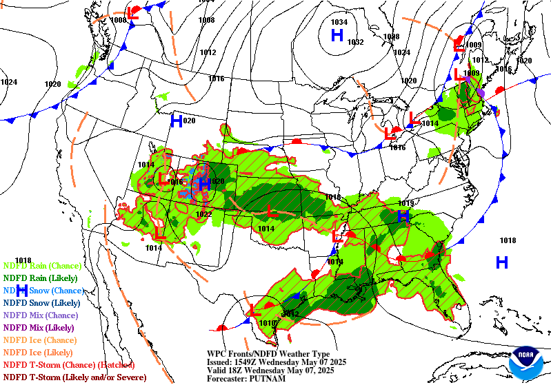
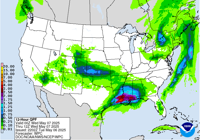
Day 1
Valid 01Z Wed May 07 2025 - 12Z Wed May 07 2025
...THERE IS A MODERATE RISK OF EXCESSIVE RAINFALL OVER PORTIONS OF
EASTERN TEXAS INTO THE LOWER MISSISSIPPI VALLEY...
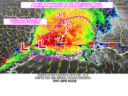
...East Texas into Lower Mississippi Valley...
Steady progression of heavy convection will continue through the
evening with a combination of discrete cells co-located within a
broad MCS propagation along the northern periphery of a sharp
theta_E gradient aligned with a slow-moving warm front. Rainfall
rates this evening will settle between 1-3"/hr with a few cells
over Southern LA and MS potentially breaching 3"/hr, especially
during intra-hour tendencies. Ascent pattern remains very favorable
with a broad cyclonic ULL positioned over the Southern Plains with
extension back into the Western CONUS. HREF EAS prob fields for >3"
is very high (>50%) across all of Central LA extending east into
the mouth of the MS just north of New Orleans. This places some
formidable metro populations within an expected corridor of heavy
rainfall that will likely lead to flash flooding through the
overnight hours. There's already been several flood reports with
associated flash flood warnings lined up along I-20 across the
ArkLaTex, now expanding east through Northern LA. Expect that trend
to continue into MS with the Jackson metro next in line for
anticipated impacts. Despite some lower EAS probs for >3" within
Jackson, there's been a considerable jump in the recent HRRR output
with a solid 2-4" anticipated within the zone of impact from the
propagating MCS. With the cell mergers taking place already across
Southwest LA, there will be a considerable footprint of 2+" totals
with embedded 3-5" amounts that will allow for broad areal coverage
of flash flood warnings the next several hours. The previously
inherited MDT risk from the afternoon remains for many, although
some of the risk was trimmed due to convective impacts already
occurring earlier in the afternoon and evening.
A line of convection remains situated across portions of East TX as
well thanks to parallel boundary layer flow up against a slow
moving cold front that appears to be quickly losing steam as it
moves eastward. Countering LLJ is causing significant degradation
of the frontal progression, something that will allow for training
echoes to be a common occurrence over the course of the evening.
The next few hours will be the most concerning periods before the
setup slowly shifts east into the Lower Sabine allowing for an
addition few inches to potentially fall over the southern portion
of I-45. The Houston metro will be an area of interest this evening
as the slow storm motions could lead to some locally enhanced
totals within the urban corridor. The best threat still looks to
lie northeast of there, but the metro remains solidly in the SLGT
risk for the update.
A MRGL risk now encompasses Deep South TX as hourly hi-res depicts
a stronger mid-level perturbation ejecting out of Coahuila with
scattered thunderstorm development likely overnight, blossoming to
the east as it interacts with the western fringes of the LLJ
component. Areas outside the urban zones will be tough to flood
considering the setup, but there are some indications of locally
heavy totals >2" in spots, so decided to expand further south to
cover for the low-end threat.
...Great Basin...
Slow-moving ULL situated over the Colorado River Basin along with
primary diurnal destabilization has led to scattered heavy
thunderstorms to blossom across portions of Southern NV, Southeast
CA, and now moving into Western AZ. This setup is a mid-tier MRGL
risk with a majority of the rainfall being beneficial for the area,
but sufficient low to mid-level buoyancy coupled with favorable
upper forcing and steep lapse rates could yield a few lingering
storms to exceed 0.50"/hr rates capable of flash flood concerns the
next 2-4 hours. Once we have a sufficient diurnal heat loss after
sunset, the convective setup will dwindle with any activity
petering out to just light showers overnight.
...Central and Southern Plains...
The primary ULL across the Plains will allow for a continued
elevated convective threat with a few heavier cores located under,
and just north of the closed reflection. Regional theta_E's are not
very impressive at the moment, but as noted via regional radar
output, some stronger mid-level vorticity is pivoting around the
general circulation allowing for some heavier convective cores to
initiate over the TX Panhandle and Southwest KS. The main precip
shield will undergo a relatively solid west to east axis of steady
precipitation with a mature axis of deformation on the northwest
flank of the ULL center. This will lead to 1-2" totals, locally
higher to occur over portions of Southwest and South-Central KS
down along the OK state line. The threat for flash flooding is low,
but still within the lower threshold when assessing the cumulative
nature of the precip anticipated. A MRGL risk was maintained for
the above area.
...Northeast...
Remnant ULL situated over the interior Northeast U.S. will pinwheel
northward with shower and storm activity continuing over the next
few hours within the Catskills and western flank of the Hudson
Valley. Elevated convective clusters will linger under the primary
circulation, but will begin to falter as we move into the overnight
period as drier air gets pulled northward around the circulation.
Additional totals of 1" are plausible across places east and
southeast of Lake Ontario which could offer an isolated flash flood
threat for areas that have already seen decent rainfall this
afternoon. The areas that had the greatest impacts earlier will
likely see the threat wane in the next hour as they see the dry air
advection regime take place.
Kleebauer
Day 1 threat area:
www.wpc.ncep.noaa.gov/qpf/94epoints.txt
Excessive Rainfall Discussion
NWS Weather Prediction Center College Park MD
843 PM EDT Tue May 6 2025
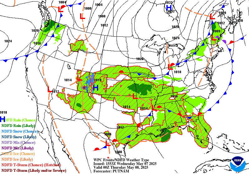
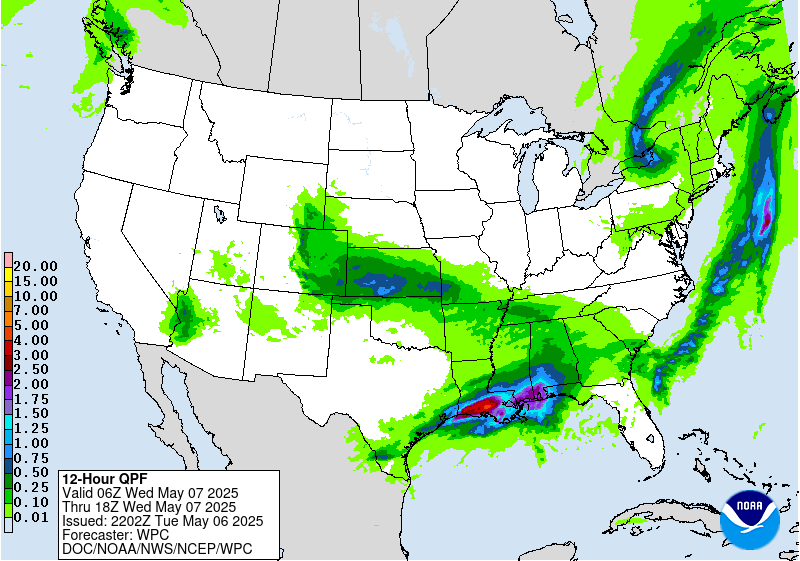
Day 2
Valid 12Z Wed May 07 2025 - 12Z Thu May 08 2025
...THERE IS A MODERATE RISK OF EXCESSIVE RAINFALL FOR PORTIONS OF
SOUTHEASTERN LOUISIANA...
...2030Z Update...
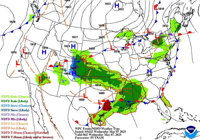
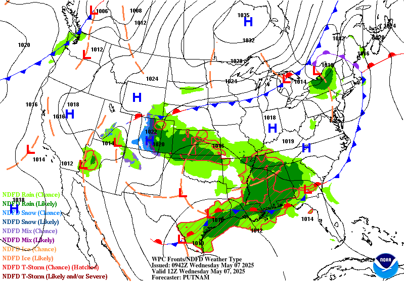
...Gulf Coast...
In coordination with LIX/Slidell, LA forecast office, a Moderate
Risk upgrade was introduced with this update for portions of
southeastern Louisiana, including the Baton Rouge and New Orleans
metros. Strong thunderstorms producing very heavy rainfall with
maximum rates up to 3 inches per hour are expected to be ongoing
across the Moderate Risk region at the start of the period 12Z
Wednesday morning. The expectation is that heavy rain will be
ongoing in the few hours prior to the start of the period, such
that additional rainfall about midway through this heavy rainfall
event at 12Z will significantly worsen already ongoing flooding.
Thus, many of the flooding impacts from the Day 1 Moderate Risk
will be experienced into the first part of this Day 2 time frame.
It is very important to note that there has been a notable
southward trend in the guidance regarding where the axis of
heaviest rainfall will set up, with the I-10 corridor from Baton
Rouge through New Orleans the likely northernmost extent of the
multiple inches of rain forecast for this area. Thus, any
additional southward trend would require a notable downgrade in the
forecasted risk areas. In other words, the "bust potential" of this
event has notably increased. Nonetheless, given the susceptibility
of the Moderate Risk area to flash flooding in both aforementioned
urban centers and along the Atchafalaya River and its spillways,
the current forecasted rainfall during this period, though almost
entirely Wednesday morning, would still likely cause numerous
instances of flash flooding, some of whom may be significant.
Regardless of exactly where the heaviest storms are occurring at
the start of the period Wednesday morning, there is very good
consensus that by as early as late Wednesday morning, the storms
will have all pushed south into the Gulf, leaving much of the
Louisiana coast in much lighter outflow from those storms to the
north of their cores. Thus, most of the threat is prior to 18Z,
with very likely downgrades likely thereafter.
Further to the west, the Slight Risk area was expanded west to
include the Houston metro in coordination with HGX/Houston, TX
forecast office. The aforementioned southward trend in the
guidance is notable here as well, but there appears to be better
consensus there may be newly developed afternoon convection
impacting the Houston Metro Wednesday afternoon. Urbanization and
susceptibility to flash flooding of that area was a considerable
factor in the upgrade for this area.
...Mid-South...
An expansive Marginal Risk area was added with this update from
Kansas to north Georgia ahead of a dying upper level low that will
slowly track eastward across the region, providing enough forcing
for widely scattered thunderstorms to take advantage of still
considerable Gulf moisture in the area. Much of this area has been
hit recently with heavy rains, which will locally increase the
flash flooding risk, especially if the upper low can help organize
any of the convection.
...Florida Space Coast...
A small Marginal Risk was added to the ERO for urbanized portions
of the I-95 corridor through north Florida along the Space Coast. A
stalled out cold front is likely to provide enough forcing given
the plentiful moisture around (PWATs exceeding 1.75 inches) to
allow any storms that form, perhaps along the sea breeze or along
the cold pools of other storms, to be slow moving and have enough
moisture to locally cause heavy rains. Isolated instances of flash
flooding are possible.
Wegman
...Previous Discussion...
By Wednesday, the warm front that lifted through the Upper Texas
coast will stall out along the Gulf Coast and be the focus for
widespread showers and thunderstorms. PWs remain above the 97.5
climatological percentiles from the Upper Texas coast to as far
east as the FL Panhandle. In fact, there are anomalous PWs that
stretch up into northern AL Wednesday afternoon. The flash flood
threat remains greatest along the central Gulf Coast and Lower
MS Valley regions where they are most commonly positioned at the
nose of a >500 kg/m/s IVT and PWs that are topping 1.75" in most
locations. RAP soundings in southern LA Wednesday morning show
low-mid level RH values >90% and warm cloud layers at least
11,000ft deep. These soundings also depict tall "skinny CAPE"
profiles with MLCAPE >500 J/kg. Plus, hodographs still suggest the
potential for organized convection given modest mid-level shear and
low-level helicity (sfc-3km >150 m2/s2). The NBM 75th percentile
shows rainfall totals >5" in some cases across the central Gulf
Coast, which is on top of the heavy rainfall that occurred on
Tuesday. The concern would be the SWrly IVT continues to intersect
the stalled frontal boundary in a way that supports training and
back-building convection that produces highly efficient rainfall
rates >2"/hr over soils that are increasingly saturated. No
Moderate Risk was hoisted as of this forecast cycle as there are
still some varying scenarios depicted by model guidance, but should
guidance come into better agreement on a swath of 3-5" amounts
and./or soils grow highly sensitive due to Tuesday's Excessive
Rainfall, a Moderate Risk upgrade could be necessary.
The Marginal Risk was expanded north into the hills of northern AL
where FFGs are lower (<2" for 1-hr FFGs) and guidance showed some
modest moisture advection via the aforementioned IVT. Given the
saturated soils in the region and the potential for locally heavy
rainfall rates, the Marginal Risk was expanded a little farther
north closer ot the TN Valley.
Mullinax
Day 2 threat area:
www.wpc.ncep.noaa.gov/qpf/98epoints.txt
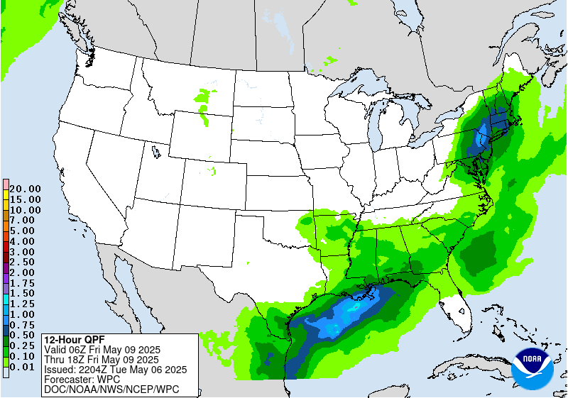
Excessive Rainfall Discussion
NWS Weather Prediction Center College Park MD
843 PM EDT Tue May 6 2025
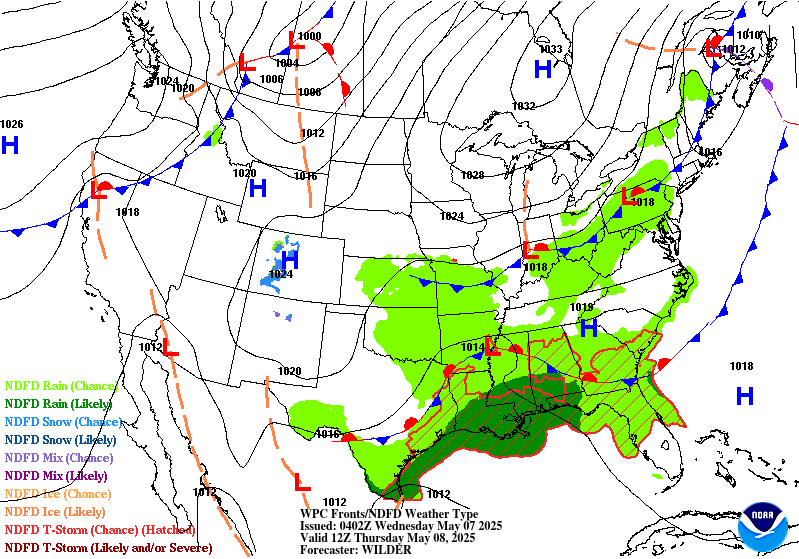
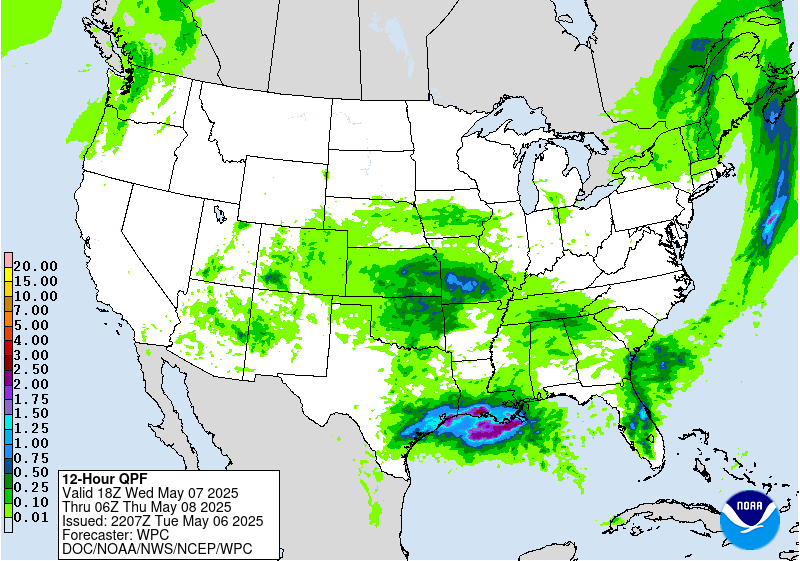
Day 3
Valid 12Z Thu May 08 2025 - 12Z Fri May 09 2025
...THERE IS A SLIGHT RISK OF EXCESSIVE RAINFALL OVER PORTIONS OF
THE CENTRAL GULF COAST...
...2030Z Update...
...Central Gulf Coast...
In coordination with LIX/Slidell, LA forecast office, a Slight Risk
upgrade was introduced with this update for portions of the central
Gulf Coast. The stalled front over the area will continue to
provide the forcing needed for additional convection to form along
the coast, possibly intruding inland as far north as New Orleans.
The area is expected to be very susceptible to flash flooding from
additional rainfall after today's and Wednesday's storms, but it's
very possible that the strongest storms impacting the area remain
offshore enough to not pose as high a flash flooding risk. However,
despite this uncertainty with where the storms will form countered
with the certainty that the soils and rivers will be full from
prior days' rainfall, there's enough certainty for the risk
upgrade.
...Southeast...
The Marginal Risk was expanded along Florida's First and Space
Coasts as well as northwest into Arkansas with this update. A
longwave very positively tilted trough will continue to provide the
forcing needed for another day of convective development across the
Southeast as plentiful Gulf moisture remains south of the surface
cold front. Due to the diffuse nature of the front and low
predictability of any surface fronts and cold pools, expect the
storms to be mostly disorganized and widely scattered, which favors
the Marginal Risk mostly for areas where the soils are more
saturated due to prior rains. For Florida, the same front will be
stuck along the coast as the Day 2/Wednesday period, resulting in
the potential for similar convection again in this period Thursday
afternoon.
...Deep South Texas...
A broad Marginal was added with this update on the tail end of the
front over the western Gulf and into Texas. A significant cold
front pushing south out of central Texas will meet up with deep
Gulf moisture over the western Gulf, which will allow for scattered
storms across the area, which will force additional convection from
prior storms' cold pools. This most areas will see at least some
period of heavy rain, which will be capable of causing isolated
instances of flash flooding.
...Northeast...
A very potent digging shortwave trough will move due south down the
Appalachians on Thursday. It will tap into increasing Gulf/Atlantic
moisture downwind of the Gulf convection, drawing moisture and
instability northward and into the Northeast, with the shortwave
providing the forcing. Instability will be the limiting factor for
any storms, with the initial development of those storms perhaps
having the greatest flash flooding threat. By the overnight
Thursday night, expect a broad swath of moderate rainfall with
embedded convection tracking northward into the Northeast. Once
again some of these same areas have had or are having heavy rain
impact the area the past couple days through the Day 2 period, so
isolated instance of flash flooding in this area appear likely with
the additional rainfall.
Wegman
...Previous Discussion...
...Central Gulf Coast...
Thursday and into Thursday night is a near carbon-copy setup to
Wednesday's where the stationary front draped W-E along the Gulf
Coast will continue to act as the initiator in additional
thunderstorms across the South. The central Gulf Coast will remain
the more primed spot for potential flash flooding given the
increasingly sensitive soils in the region after multiple days of
heavy rainfall. PWs ranging between 1.6-1.8" will be common with
MLCAPE that tops 1,000 J/kg. Thunderstorms could produce >2"/hr
rainfall rates across the Marginal Risk area. Should guidance trend
wetter in the coming days, it is possible a Slight Risk upgrade may
be necessary given the soils more sensitive state.
...Northeast...
No Marginal Risk was introduced tonight, but this region bears
watching as a cold front approaches from the West. Several guidance
members now show 1-2" of rainfall across portions of the region on
Thursday, however they vary on where those heavier amounts are most
likely to occur. A positively tilted upper trough approaching from
Ontario will provide plenty of upper-level ascent while the
approaching cold front acts as the surface/low-level trigger for
initiating thunderstorms. Plus, some guidance members show the
positively-tilted trough cutting off just enough to where an 850mb
low forms near the Northeast coast. This is not the case across all
guidance and is resulting in rainfall swaths that are farther
north over the interior Northeast (GFS/ECMWF/ICON), or as far
south and east as the I-95 corridor (EC-AIFS/CMC/UKMET/RRFS). With
lingering uncertainty in the forecast, the Marginal Risk upgrade
was held off this forecast cycle. But given the highly saturated
soils in the region, it is possible a Marginal Risk will be
necessary in future forecast updates once confidence increases in
where the heaviest swath of rainfall occurs.
Mullinax
Day 3 threat area:
www.wpc.ncep.noaa.gov/qpf/99epoints.txt
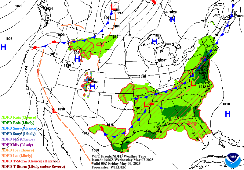
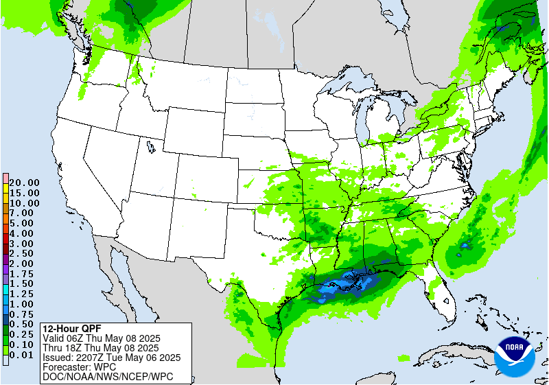
Extended Forecast Discussion
NWS Weather Prediction Center College Park MD
301 PM EDT Tue May 6 2025
Wavy frontal system and closed upper trough/low stagnation over the
Southeast will continue to support a multi-day heavy
rainfall/runoff threat as fueled by pooling anomalous moisture.
Relatively dry antecedent conditions and higher flash flood
guidance may limit the overall flash flooding potential initially.
Opted to maintain WPC Excessive Rainfall Outlook Marginal risks
for Days 4/5 (Friday/Saturday) for now, but repeat cells/training
along with subsequent cumulative effects may lead to threat level
upgrades as the supporting guidance signal continues to increase.
Areas of rain are also possible in the northeastern U.S. at times
later this week into the weekend with an initial energy push
inland.
Increasingly widespread rain and very high elevation snows may
move back into the West with more gusty into next week associated
with amplified upper troughing and surface system approach.
General troughing from the Northeast to the South will keep
temperatures near or below normal at least through the weekend.
Meanwhile out West, upper ridging will support much above normal
temperatures with daytime highs 10-20+ degrees above normal
progressing from the Northwest into the Northern Plains. Parts of
the Southwest should approach 100 degrees.
Santorelli/Schichtel


