Excessive Rainfall Discussion
NWS Weather Prediction Center College Park MD
1159 AM EDT Sat May 3 2025
Day 1
Valid 16Z Sat May 03 2025 - 12Z Sun May 04 2025
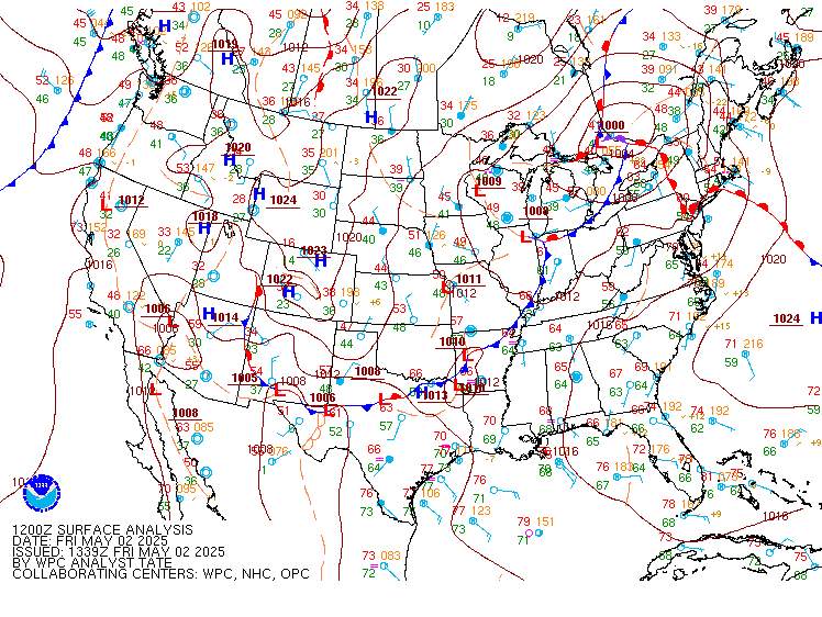
...THERE IS A MARGINAL RISK OF EXCESSIVE RAINFALL FOR MUCH OF THE
EASTERN U.S. AND THE SACRAMENTO MOUNTAINS OF NEW MEXICO...
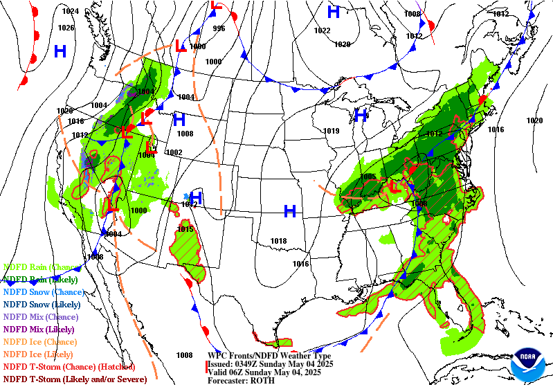
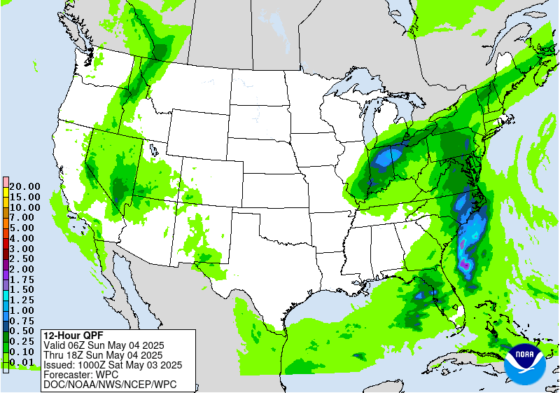
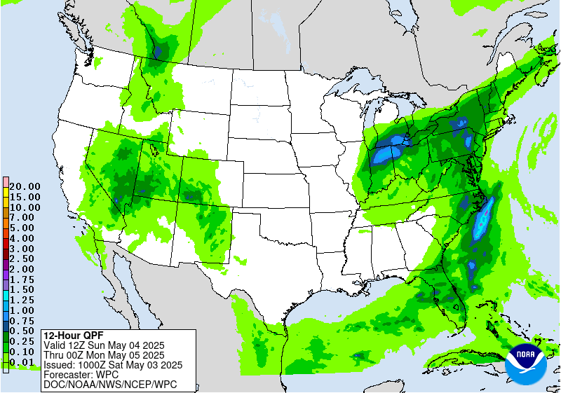
16Z Update...
An upper-level low is forming over the mid-Mississippi region and
becomes cutoff over Kentucky tonight as the jet focuses over
eastern Canada. Low level flow is drawing Gulf moisture through and
ahead of the system from the Gulf Coast up through the Eastern
Seaboard. Several focus areas for thunderstorms are expected
through tonight in the broad area which covered by a contiguous
Marginal Risk.
Ohio Valley to Gulf Coast...
Locally heavy activity has developed ahead of a surface low over
western TN with scattered storms south ahead of the advancing cold
front through MS and north along a stalled boundary that extends to
the upper Ohio Valley. This activity may pivot over eastern
KY/southern OH through the middle afternoon while activity over AL
to the Gulf Coast should be more progressive.
Carolinas, Central Appalachians and Mid-Atlantic...
Lee trough development over the Piedmont in the Carolinas later
this afternoon will allow potentially training activity in deep
SSWly flow there well into the evening, so the Marginal Risk was
expanded east a bit over SC/NC. This activity lifts north through
the central Appalachians into this evening with localized flash
flood threats. Later tonight the activity shifts east with some
training potential, so the Marginal was maintained east through the
Baltimore/Washington urban centers.
Northeast...
The northern end of the moisture plume converges on a frontal zone
over Upstate NY and central New England through this afternoon
bringing potential for excessive rain despite strong deep layer
flow. The Marginal Risk was expanded north into central New
England. A second round of development is expected farther south
this evening in the Hudson Valley and southern New England which
was already covered by a Marginal.
New Mexico...
Afternoon convection over the Sacramento Mtns brings a threat for
runoff issues from burn scars into this evening, so the Marginal
Risk is maintained.
Jackson
Day 1 threat area:
www.wpc.ncep.noaa.gov/qpf/94epoints.txt
Day 1
Valid 16Z Sat May 03 2025 - 12Z Sun May 04 2025
...THERE IS A MARGINAL RISK OF EXCESSIVE RAINFALL FOR MUCH OF THE
EASTERN U.S. AND THE SACRAMENTO MOUNTAINS OF NEW MEXICO...
16Z Update...
An upper-level low is forming over the mid-Mississippi region and
becomes cutoff over Kentucky tonight as the jet focuses over
eastern Canada. Low level flow is drawing Gulf moisture through and
ahead of the system from the Gulf Coast up through the Eastern
Seaboard. Several focus areas for thunderstorms are expected
through tonight in the broad area which covered by a contiguous
Marginal Risk.
Ohio Valley to Gulf Coast...
Locally heavy activity has developed ahead of a surface low over
western TN with scattered storms south ahead of the advancing cold
front through MS and north along a stalled boundary that extends to
the upper Ohio Valley. This activity may pivot over eastern
KY/southern OH through the middle afternoon while activity over AL
to the Gulf Coast should be more progressive.
Carolinas, Central Appalachians and Mid-Atlantic...
Lee trough development over the Piedmont in the Carolinas later
this afternoon will allow potentially training activity in deep
SSWly flow there well into the evening, so the Marginal Risk was
expanded east a bit over SC/NC. This activity lifts north through
the central Appalachians into this evening with localized flash
flood threats. Later tonight the activity shifts east with some
training potential, so the Marginal was maintained east through the
Baltimore/Washington urban centers.
Northeast...
The northern end of the moisture plume converges on a frontal zone
over Upstate NY and central New England through this afternoon
bringing potential for excessive rain despite strong deep layer
flow. The Marginal Risk was expanded north into central New
England. A second round of development is expected farther south
this evening in the Hudson Valley and southern New England which
was already covered by a Marginal.
New Mexico...
Afternoon convection over the Sacramento Mtns brings a threat for
runoff issues from burn scars into this evening, so the Marginal
Risk is maintained.
Jackson
Day 1 threat area:
www.wpc.ncep.noaa.gov/qpf/94epoints.txt
Excessive Rainfall Discussion
NWS Weather Prediction Center College Park MD
1159 AM EDT Sat May 3 2025
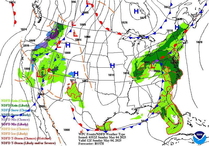
Day 2
Valid 12Z Sun May 04 2025 - 12Z Mon May 05 2025
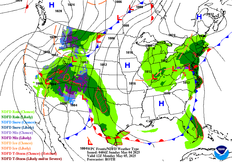
...THERE IS A MARGINAL RISK OF EXCESSIVE RAINFALL OVER PARTS OF THE
EASTERN UNITED STATES AND SOUTHERN ROCKIES AND ADJACENT HIGH PLAINS...
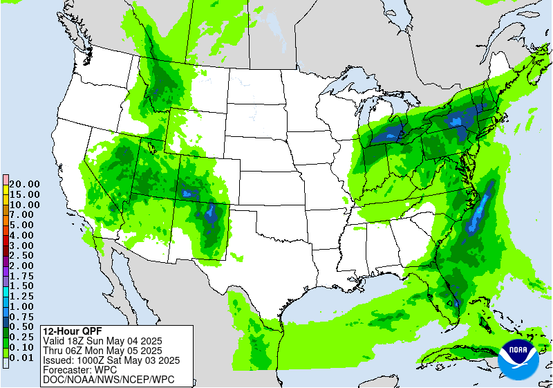
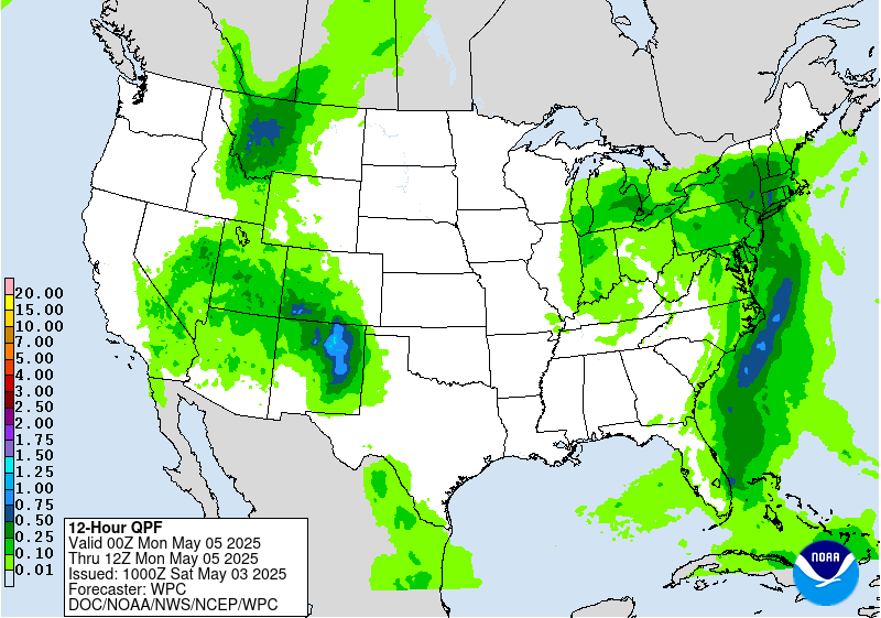
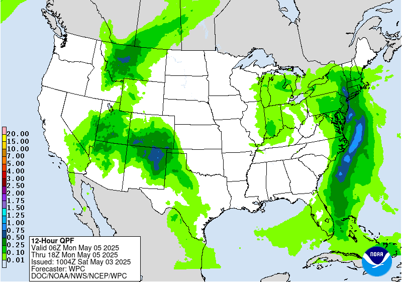
The risk of excessive rainfall persists across parts of the Mid-
Atlantic and Southeast US as a slow moving closed low embedded
within a broader upper trough continues to make its way eastward. Deepest
moisture of 1.25 to 1.5 inches will be eventually be shunted off-
shore late in the period. Until then...isolated downpours are
possible with spaghetti plots of 2 and 3-inches of rain in 24 hours
mainly being produced by models with the ARW core...but enough
members from the NMM core and from the GEFS to warrant a Marginal.
The western boundary of the Marginal was trimmed compared with the
previous outlook given the models being more progressive with the
surface cold front and the push of drier air being brought in
behind the front.
There is also a Marginal Risk area over parts of New Mexico again
as moisture continue to spread northward and westward from the
Gulf. After 00Z...the flow aloft between the westerly subtropical
jet and a jet streak and low- and mid-levels become increasingly
diffluent with height falls beginning ahead of an approaching
closed low from the west. This...along with moisture and a low
level boundary already in place...should support late day and
evening storms that may produce locally heavy rainfall rates.
Bann
Day 2 threat area:
www.wpc.ncep.noaa.gov/qpf/98epoints.txt
Day 2
Valid 12Z Sun May 04 2025 - 12Z Mon May 05 2025
...THERE IS A MARGINAL RISK OF EXCESSIVE RAINFALL OVER PARTS OF THE
EASTERN UNITED STATES AND SOUTHERN ROCKIES AND ADJACENT HIGH PLAINS...
The risk of excessive rainfall persists across parts of the Mid-
Atlantic and Southeast US as a slow moving closed low embedded
within a broader upper trough continues to make its way eastward. Deepest
moisture of 1.25 to 1.5 inches will be eventually be shunted off-
shore late in the period. Until then...isolated downpours are
possible with spaghetti plots of 2 and 3-inches of rain in 24 hours
mainly being produced by models with the ARW core...but enough
members from the NMM core and from the GEFS to warrant a Marginal.
The western boundary of the Marginal was trimmed compared with the
previous outlook given the models being more progressive with the
surface cold front and the push of drier air being brought in
behind the front.
There is also a Marginal Risk area over parts of New Mexico again
as moisture continue to spread northward and westward from the
Gulf. After 00Z...the flow aloft between the westerly subtropical
jet and a jet streak and low- and mid-levels become increasingly
diffluent with height falls beginning ahead of an approaching
closed low from the west. This...along with moisture and a low
level boundary already in place...should support late day and
evening storms that may produce locally heavy rainfall rates.
Bann
Day 2 threat area:
www.wpc.ncep.noaa.gov/qpf/98epoints.txt
Excessive Rainfall Discussion
NWS Weather Prediction Center College Park MD
1159 AM EDT Sat May 3 2025
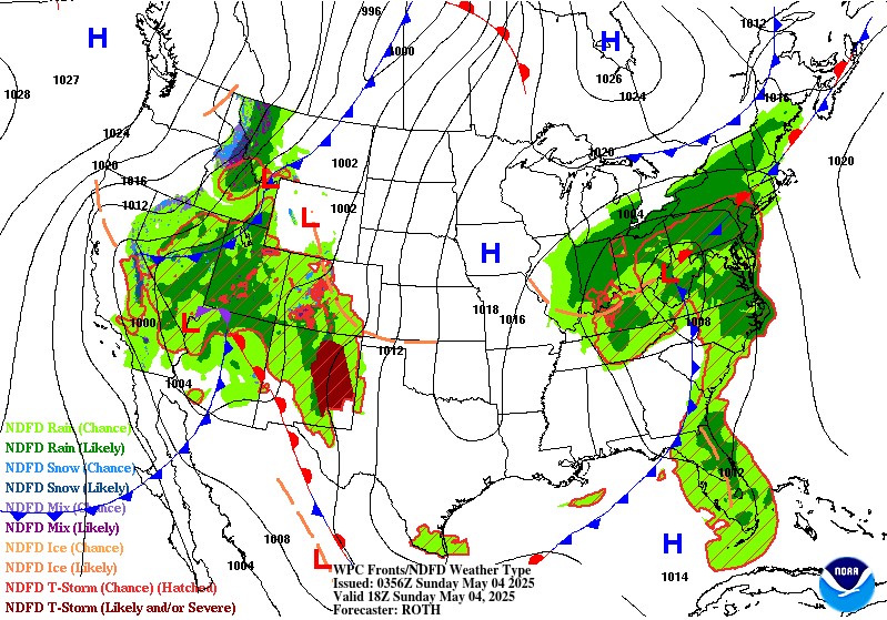
Day 3
Valid 12Z Mon May 05 2025 - 12Z Tue May 06 2025
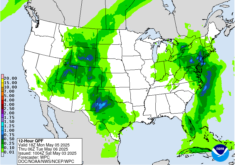
...THERE IS A SLIGHT RISK OF EXCESSIVE RAINFALL OVER PORTIONS OF
THE HIGH PLAINS ADJACENT TO THE SOUTHERN ROCKIES...
Shortwave energy rotating around the periphery of an upper low
making its way over the Southwest US will trigger late day
thunderstorms on Monday over parts of West Texas that grow upscale
in terms of both coverage and rainfall amounts through much of
Monday night/early Tuesday morning. A feed of low level moisture
being forced upslope ahead of the approaching shortwave will help
fuel the potential for downpours and locally heavy rainfall amounts
leading to the potential of flash flooding. QPF from the
operational models have maximum amounts of rainfall in the 2.5 to
3.8 inches...which tended to be supported by the SREF and GEFS
spaghetti plots and by machine learning first guess EROs. Felt a
Slight Risk area covers the potential for time being.
Bann
Day 3 threat area:
www.wpc.ncep.noaa.gov/qpf/99epoints.txt
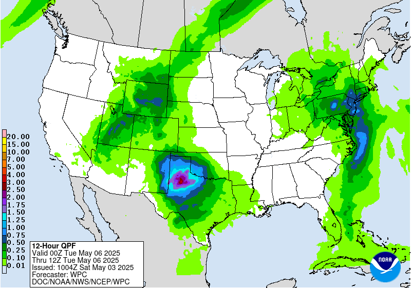
Day 3
Valid 12Z Mon May 05 2025 - 12Z Tue May 06 2025
...THERE IS A SLIGHT RISK OF EXCESSIVE RAINFALL OVER PORTIONS OF
THE HIGH PLAINS ADJACENT TO THE SOUTHERN ROCKIES...
Shortwave energy rotating around the periphery of an upper low
making its way over the Southwest US will trigger late day
thunderstorms on Monday over parts of West Texas that grow upscale
in terms of both coverage and rainfall amounts through much of
Monday night/early Tuesday morning. A feed of low level moisture
being forced upslope ahead of the approaching shortwave will help
fuel the potential for downpours and locally heavy rainfall amounts
leading to the potential of flash flooding. QPF from the
operational models have maximum amounts of rainfall in the 2.5 to
3.8 inches...which tended to be supported by the SREF and GEFS
spaghetti plots and by machine learning first guess EROs. Felt a
Slight Risk area covers the potential for time being.
Bann
Day 3 threat area:
www.wpc.ncep.noaa.gov/qpf/99epoints.txt
Extended Forecast Discussion
NWS Weather Prediction Center College Park MD
300 AM EDT Sat May 3 2025
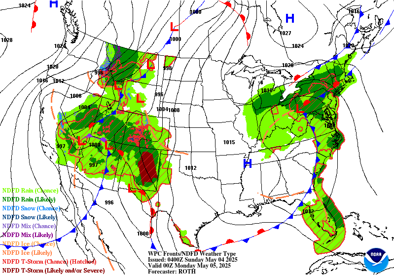
In the West, anomalous moisture accompanying the upper low will
support heightened precipitation from the Great Basin to the
Central and Southern Rockies and Plains. Into Tuesday, the system
should be more or less stationary over the Plains, allowing for
anomalous moisture to continuously pool near a boundary in the
vicinity. Several rounds of moisture- laden thunderstorms are
likely to result in a multi- day heavy rainfall event across the
Central and Southern Plains and into the lower Mississippi Valley
through Wednesday. Portions of the Plains into the Lower
Mississippi Valley states will be especially vulnerable to heavy
rain/flooding due to recent heavy rains and saturated soils. This
activity is highlighted in the Day 4-5 Excessive Rainfall Outlooks
(EROs). For Tuesday, there is a growing signal with high confidence
of widespread 2-5"+ rainfall amounts across portions of the
ArkLaTex and Lower Mississippi Valley warranting a moderate risk
upgrade for far eastern Texas into Louisiana, with a broad slight
risk extending eastward from here, as well as back into Oklahoma.
On Wednesday, the activity shifts more towards the coast, though
some guidance indicates potential for additional very heavy
rainfall. A lot of uncertainty in the amounts and placement though,
so just a slight risk is indicated on the Day 5 ERO across
Louisiana into southern Mississippi, some of which overlaps with
the activity on Day 4 as well. Activity may linger across the
Southeast into late week as the frontal boundary slows. Moderate
snowfall is expected on Tuesday as well for parts of the central
Rockies.
Under the eastern upper low, the frontal system will very slowly
push eastward early next week, resulting in a stream of onshore
moisture over the Mid-Atlantic and Northeast and persistent
precipitation across these regions. Initially, rainfall could be
beneficial and bring some relief to drought conditions, but
repeated rounds of rainfall could produce locally heavy totals and
may result in localized flooding in urban and poor drainage areas.
The Day 4-5 EROs show a Marginal Risk area across parts of the Mid-
Atlantic and Northeast.
The upper low over the Southwest early in the week will result in
below to well below normal temperatures for the Southwest/Plains
where daytime highs could be 15-20 degrees below normal. This
should moderate with time but may still remain modestly below
normal into late week for the southern Plains. Upper ridging
building over the west as the upper low shifts east will allow for
expanding coverage of above normal temperatures next week.
Santorelli
Extended Forecast Discussion
NWS Weather Prediction Center College Park MD
300 AM EDT Sat May 3 2025
In the West, anomalous moisture accompanying the upper low will
support heightened precipitation from the Great Basin to the
Central and Southern Rockies and Plains. Into Tuesday, the system
should be more or less stationary over the Plains, allowing for
anomalous moisture to continuously pool near a boundary in the
vicinity. Several rounds of moisture- laden thunderstorms are
likely to result in a multi- day heavy rainfall event across the
Central and Southern Plains and into the lower Mississippi Valley
through Wednesday. Portions of the Plains into the Lower
Mississippi Valley states will be especially vulnerable to heavy
rain/flooding due to recent heavy rains and saturated soils. This
activity is highlighted in the Day 4-5 Excessive Rainfall Outlooks
(EROs). For Tuesday, there is a growing signal with high confidence
of widespread 2-5"+ rainfall amounts across portions of the
ArkLaTex and Lower Mississippi Valley warranting a moderate risk
upgrade for far eastern Texas into Louisiana, with a broad slight
risk extending eastward from here, as well as back into Oklahoma.
On Wednesday, the activity shifts more towards the coast, though
some guidance indicates potential for additional very heavy
rainfall. A lot of uncertainty in the amounts and placement though,
so just a slight risk is indicated on the Day 5 ERO across
Louisiana into southern Mississippi, some of which overlaps with
the activity on Day 4 as well. Activity may linger across the
Southeast into late week as the frontal boundary slows. Moderate
snowfall is expected on Tuesday as well for parts of the central
Rockies.
Under the eastern upper low, the frontal system will very slowly
push eastward early next week, resulting in a stream of onshore
moisture over the Mid-Atlantic and Northeast and persistent
precipitation across these regions. Initially, rainfall could be
beneficial and bring some relief to drought conditions, but
repeated rounds of rainfall could produce locally heavy totals and
may result in localized flooding in urban and poor drainage areas.
The Day 4-5 EROs show a Marginal Risk area across parts of the Mid-
Atlantic and Northeast.
The upper low over the Southwest early in the week will result in
below to well below normal temperatures for the Southwest/Plains
where daytime highs could be 15-20 degrees below normal. This
should moderate with time but may still remain modestly below
normal into late week for the southern Plains. Upper ridging
building over the west as the upper low shifts east will allow for
expanding coverage of above normal temperatures next week.
Santorelli


