Short Range Forecast Discussion
NWS Weather Prediction Center College Park MD
400 AM EDT Tue May 06 2025
Valid 12Z Tue May 06 2025 - 12Z Thu May 08 2025
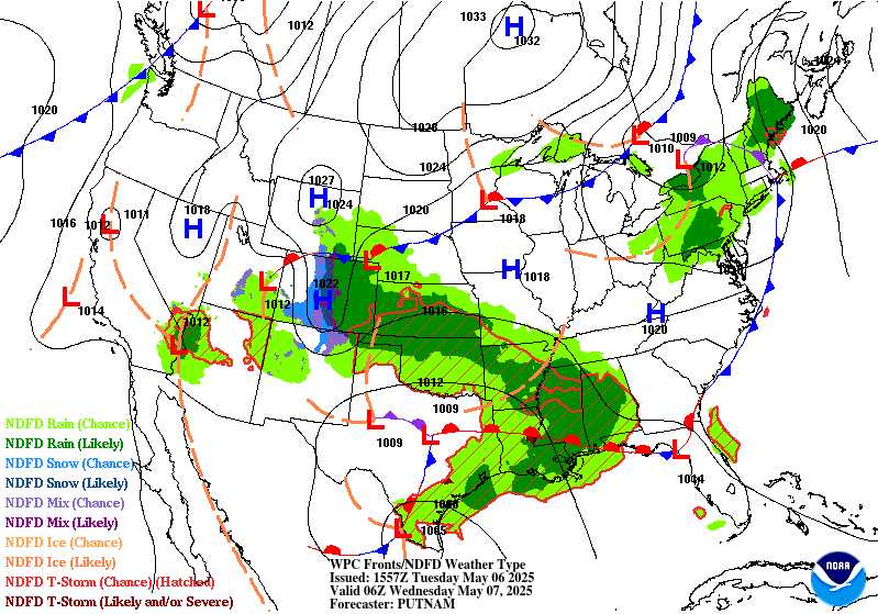
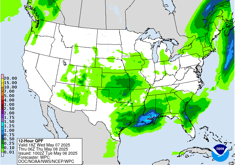
...Widespread showers and storms to bring scattered to numerous instances
of flash flooding and severe weather to portions of Texas and the Lower
Mississippi Valley Tuesday...
...Showers and storms continue to linger across much of the Ohio
Valley/Lower Great Lakes and Northeast through Tuesday...
...Cooler, well below average temperatures persist across much of the
Interior West and central/southern Plains as the northern Plains/Upper
Midwest remain much above average through mid-week...
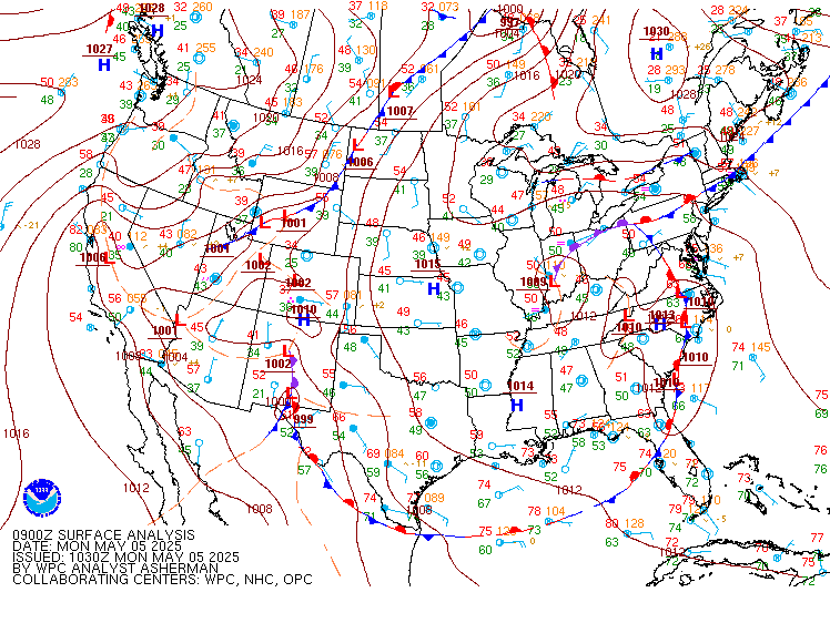
A stagnant, omega block pattern over the CONUS with an upper-low over the
Ohio Valley and another upper-low over the Southwest will begin to break
down over the next couple of days as both lows begin to make some eastward
progress, but not before another couple days of associated unsettled
weather with a threat for flash flooding and severe storms. The upper-low
over the Southwest and an accompanying surface low pressure/frontal system
emerging across the Plains this morning will provide the focus for
continued widespread showers and thunderstorms across much of the
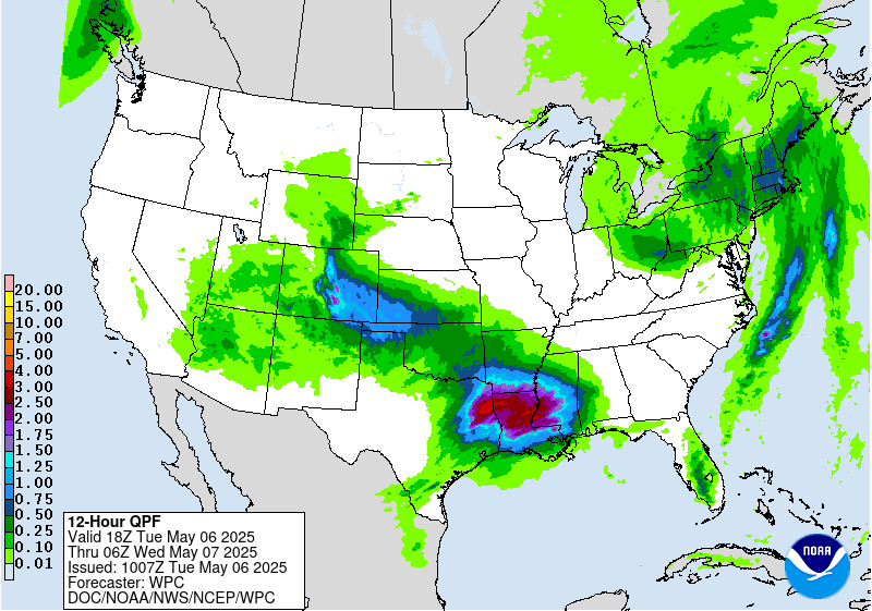
central/southern Plains and Lower Mississippi Valley. An influx of
anomalously high Gulf moisture northwestward along a quasi-stationary
front stretching across Texas and Louisiana will lead to locally heavy
downpours with repeated rounds of rainfall expected as a complex of storms
moves roughly parallel to the boundary. A Moderate Risk of Excessive
Rainfall (ERO) is in effect from eastern Texas eastward through the Lower
Mississippi Valley as scattered to numerous instances of flash flooding
are expected. A broader Slight Risk (level 2/4) extends northwestward as
additional storms are expected north of the boundary across Oklahoma and
in upslope flow through the Texas Panhandle into southeastern
Colorado/northeastern New Mexico, with additional scattered instances of
flash flooding possible. In addition, cooler air aloft and increasing
winds with the approaching upper-low will lead to very strong instability
and both deep and low-level shear more than sufficient for some intense,
supercell thunderstorms along and south of the front across southeastern
Texas. The Storm Prediction Center has issued an Enhanced Risk of severe
weather (level 3/5) for the threat of a few tornadoes, some of which could
be strong, as well as large hail and damaging winds. More scattered severe
storms are expected broadly from the Lower Mississippi Valley west through
central and northwest Texas, with large hail, especially for
northwest/central Texas, damaging winds, and a few tornadoes possible.
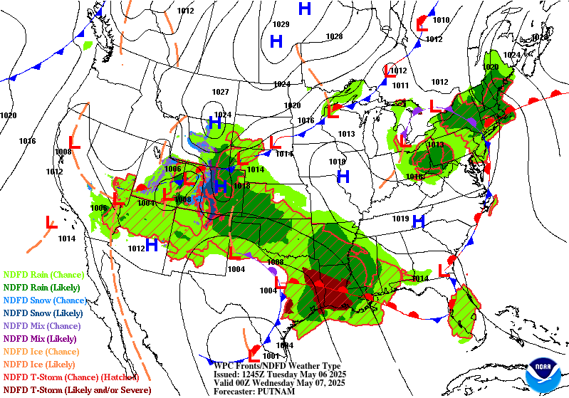
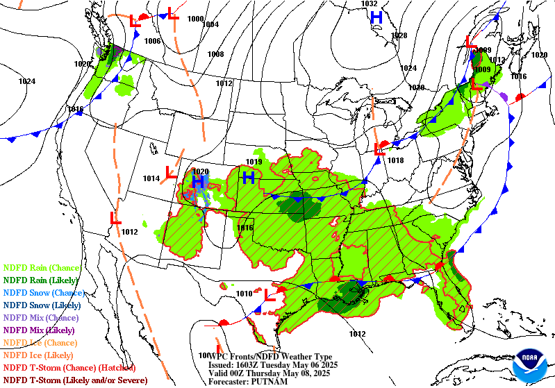
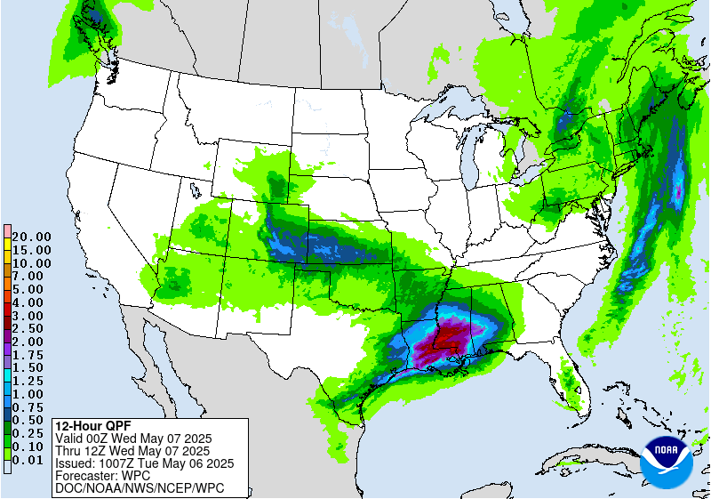
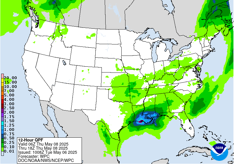
The upper-low will make slow eastward progress on Tuesday, with the
aforementioned frontal boundary sagging southward towards the Gulf Coast
but generally remaining quasi-stationary. Another round of widespread
storms is expected along the boundary, particularly along the central Gulf
Coast. Locally heavy downpours and repeated rounds of rainfall as storms
cluster along the boundary have prompted a Slight Risk ERO for scattered
flash flooding. More scattered storms with moderate rainfall are expected
across the Southeast, as well as in the central Plains ahead of a
secondary frontal boundary pushing southward through the region. Lingering
showers and storms will also continue under the upper-low over the Four
Corners region Monday. Snow is ongoing for higher elevations of the
Rockies in Colorado and north-central New Mexico, with some heavy snow
totals of 1-2'+ forecast Tuesday for the Front Range of the Rockies given
the focused moist upslope flow from the east. Most of this precipitation
will come to an end by Tuesday as the upper-low continues east.
Showers and storms also continue this morning under the eastern upper-low
over the Ohio Valley and ahead of an accompanying surface frontal system
through the Northeast/Mid-Atlantic. Moderate to locally heavy rainfall is
most likely from the Lower Great Lakes/Upper Ohio Valley east through the
northern Mid-Atlantic and into New England, with some isolated flash
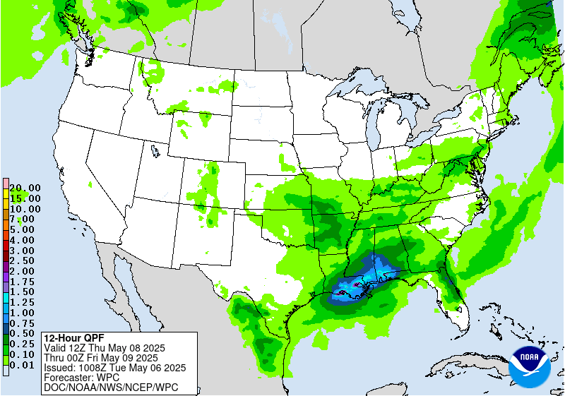
flooding possible. Conditions should begin to dry out from west to east
overnight Tuesday as the upper-low opens into a wave and finally begins to
move eastward, with some lingering lighter rain chances Wednesday mainly
for the interior Northeast and New England. Elsewhere, scattered daily
thunderstorm chances are expected for Florida ahead of a frontal boundary
lingering through the region. A Pacific system moving into the Pacific
Northwest will bring some light rain chances Wednesday afternoon/evening.
Persistent well below average and well above average temperatures are
forecast through mid-week as the omega block pattern lingers for a couple
more days. The most anomalously cooler temperatures stretch across much of
the Interior West and into the central/southern Plains under the western
upper-low. Forecast highs Tuesday and Wednesday are mainly in the 50s and
60s, with 60s and 70s for the Desert Southwest and portions of the
Southern Plains. Below average temperatures are also expected through the
Ohio Valley/Lower Great Lakes, with highs in the 50s and 60s, and into the
Southeast, with highs in the 60s and 70s. The East Coast will be closer to
average for most locations, with some cooler temperatures across New
England in the 50s and 60s, but some warmer temperatures south with 60s
and 70s in the Mid-Atlantic and 80s from the Carolinas south to Florida.
In contrast, highs over the northern Plains and Upper Midwest remain
well-above average and into the 70s and 80s for many locations. The West
Coast will also be well above average as a ridge builds northward in the
wake of the upper-low, with highs in the 70s and 80s. These warmer
temperatures will spread inland for northern portions of the Interior West
by Wednesday.
Putnam
Graphics available at
https://www.wpc.ncep.noaa.gov/basicwx/basicwx_ndfd.php


