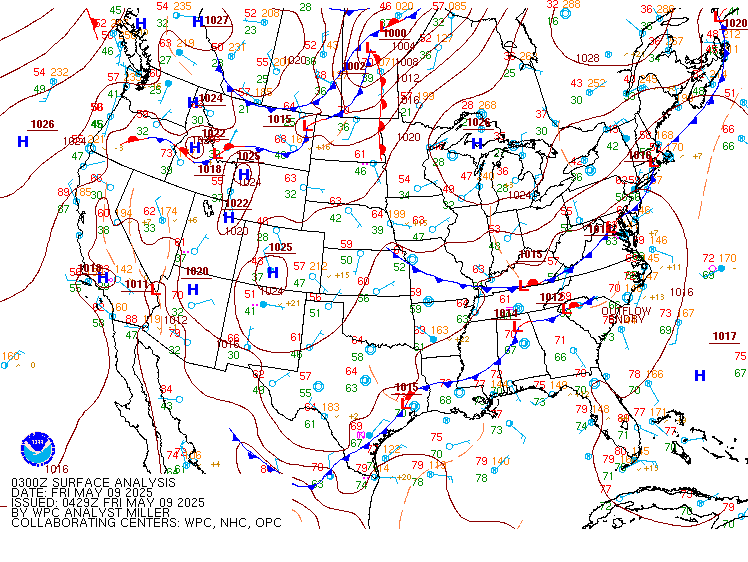
Excessive Rainfall Discussion
NWS Weather Prediction Center College Park MD
859 PM EDT Fri May 9 2025
Day 1
Valid 01Z Sat May 10 2025 - 12Z Sat May 10 2025
...THERE IS A MARGINAL RISK OF EXCESSIVE RAINFALL OVER PORTIONS OF
THE CENTRAL GULF COAST...
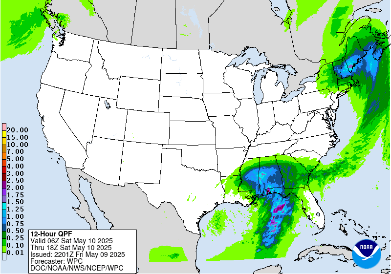
Convection along the central Gulf Coast will continue to pose an
isolated flash flood risk tonight. One more round of intense
convection is expected to move into coastal areas tonight into
early Saturday, although some model differences remain with the
specifics. The 12z REFS is the furthest west, bringing a max into
southern MS, with the 23z HRRR the furthest east, more into the
western FL Panhandle. At this point leaning a bit more towards the
recent HRRR runs, but in reality anywhere from southern MS to the
western FL Panhandle is in play for additional heavy convection and
3"+ more of rain in spots. Not seeing quite enough model
consistency to go with a Slight risk, but with earlier rainfall
increasing saturation...it does seem probable that at least a few
more instances of flash flooding will occur into the overnight
hours wherever this stronger convection moves onshore.
Chenard
Day 1 threat area:
www.wpc.ncep.noaa.gov/qpf/94epoints.txt
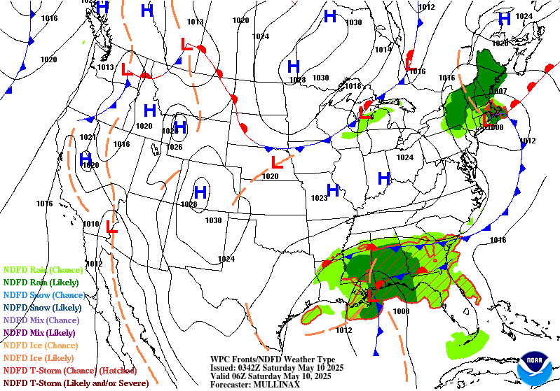
Excessive Rainfall Discussion
NWS Weather Prediction Center College Park MD
859 PM EDT Fri May 9 2025
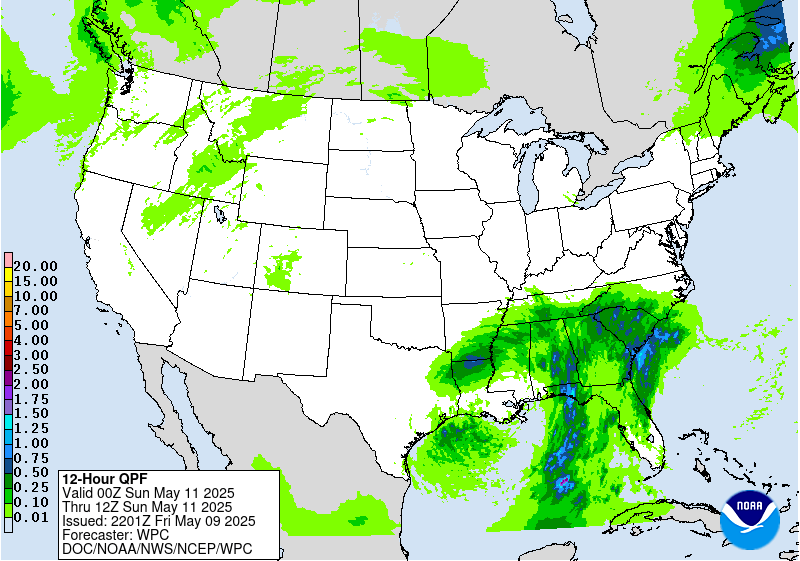
Day 2
Valid 12Z Sat May 10 2025 - 12Z Sun May 11 2025
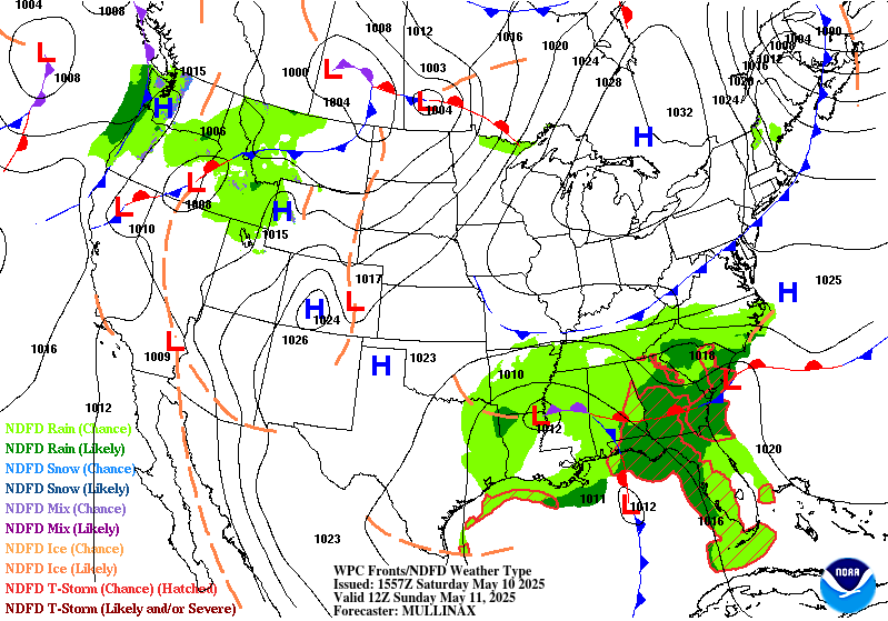
...THERE IS A MARGINAL RISK OF EXCESSIVE RAINFALL OVER PORTIONS OF
THE SOUTHEAST & NEW ENGLAND...
20Z Update: The previous forecast remains on track for both the
Southeast and Northeastern U.S MRGL risk areas as the overall run
to run consistency in the synoptic pattern has yielded similar QPF
outputs within the recent 12z guidance. The heaviest rain across
the Southeast will translate eastward due to the mean trough
pattern over the Southern Plains shifting more towards the
Mississippi Valley longitude. Surface low across the Gulf will
occlude and wander north and northwest during the course of the
period with deep layer flow basically aligned south to north from
the FL Panhandle up through AL/GA. Surface and upper lows will
become vertically stacked by Saturday afternoon leading to slow
storm motions under the parent circulation with a steady push south
to north within the eastern flank of the circulations. Scattered
to numerous thunderstorms will accompany both areas of interest
leading to the risk area encompassing a sprawling zone with the
cyclonic arc back towards the Mississippi Valley on the northwest
side of the circulation.
Stalled front along the Southeast Atlantic coast extending through
Southern GA will act as an inflection point for convection with
mean storm motions likely aligned with the boundary as you work
from southwest to northeast (Tallahassee to Charleston, SC line).
This will lead to a secondary maxima developing over the course of
Saturday morning and afternoon, a consistent signature within the
latest CAMs. The primary axis of interest will reside over the
Western FL Peninsula up through the AL/GA line till about the I-20
corridor. Despite the overall setup indicating 1-3" of rainfall
with locally higher in that vicinity, the area in question is under
the influence of a D0-2 drought so the threat of flash flooding
with the current forecasted rates should help curb the threat
initially (See D3 discussion below). The MRGL was maintained
outside some expansions on the northern periphery of the risk area
to align with current QPF.
Northeast U.S. saw the western edge towards VT brought back further
east as the forecast surface low progression and subsequent dry air
advection pattern behind the vacating low will yield less of a risk
of persistent rainfall in that portion of New England. There was
enough consensus to trim part of the risk area to account for the
changes leading to NH and ME as the only areas where the risk was
maintained. QPF details remain steadfast from previous forecast
with locally moderate to heavy rainfall leading to an areal
average of 0.75-1.5" of rainfall with upwards of 2" plausible over
Central ME down towards the Southern ME coast.
Kleebauer
..Previous Discussions..
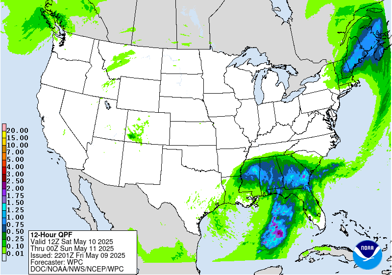
...Southeast...
A stationary boundary will remain draped across the Southeast,
with several waves of low pressure expected to form along the
boundary over the weekend as upper level short waves pivot around
the upper low over the region. Compared to Friday, the QPF
footprint will translate east into areas with relatively drier
antecedent conditions. Models are agreeable that widespread
rainfall totals of 1-2 inches are expected across southern and
central Alabama and Georgia and North Florida. Locally higher
amounts above 2 inches will also be possible, but exactly where may
vary within the region. The highest QPF will likely be along the
immediate coast in the Florida panhandle as convection moves
onshore, and training onshore convection will likely pose the
highest threat for flash flooding. Efficient rain rates (2+ inches
per hour) are expected due to a saturated atmosphere with ample
CAPE and shear to support thunderstorms. Flash flooding may be
fairly limited to urban and poor drainage areas given the higher
FFGs (3-5 inches). To account for this, a Marginal Risk area is in
place across much of the Southeast.
...New England...
As a coastal low tracks south of the coast, moderate precipitation
will focus over New England on the northern side of the system.
The low is expected to be fairly progressive, which might help to
limit rainfall totals, but a decent swatch of rainfall is forecast
from Vermont and New Hampshire through southern Maine. Soils in
Vermont and New Hampshire are expected to be somewhat sensitive
given heavy rains expected today. Rainfall will be mostly
stratiform across New England, limiting rain rates, but there will
likely be enough moisture and instability to produce localized
rates of 1+ inches over the course of a few hours, which may come
close to 3/6 hr FFGs. A Marginal Risk area remains in place across
Vermont, New Hampshire, and most of Maine, but northwestern Maine
was removed from the Marginal as model QPF has trended downwards.
Dolan
Day 2 threat area:
www.wpc.ncep.noaa.gov/qpf/98epoints.txt
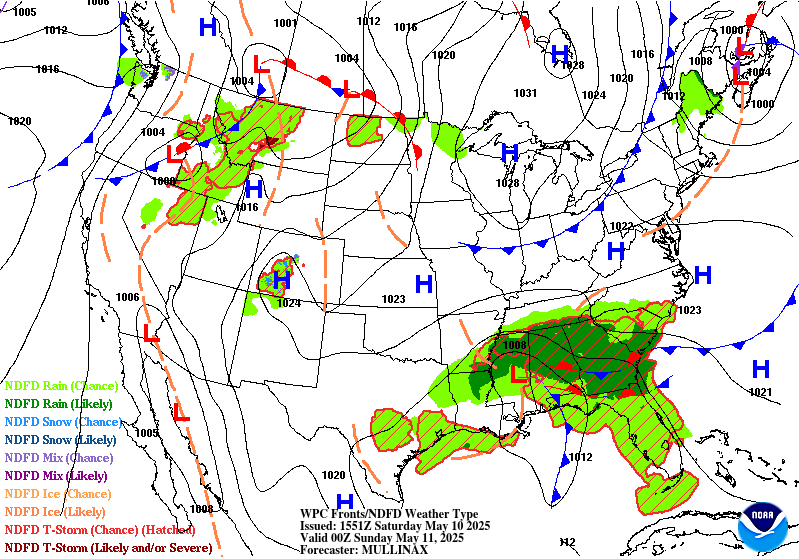
Excessive Rainfall Discussion
NWS Weather Prediction Center College Park MD
859 PM EDT Fri May 9 2025
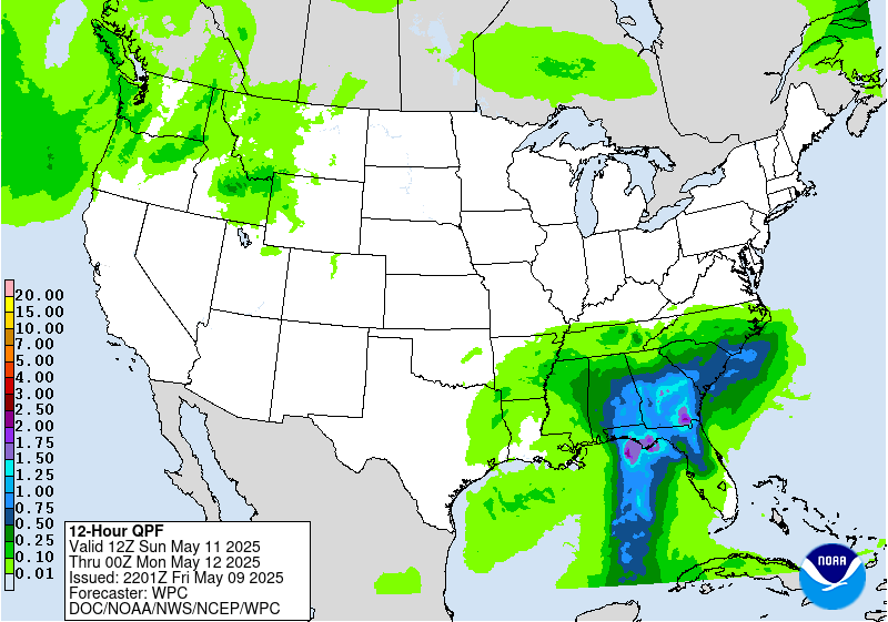
Day 3
Valid 12Z Sun May 11 2025 - 12Z Mon May 12 2025
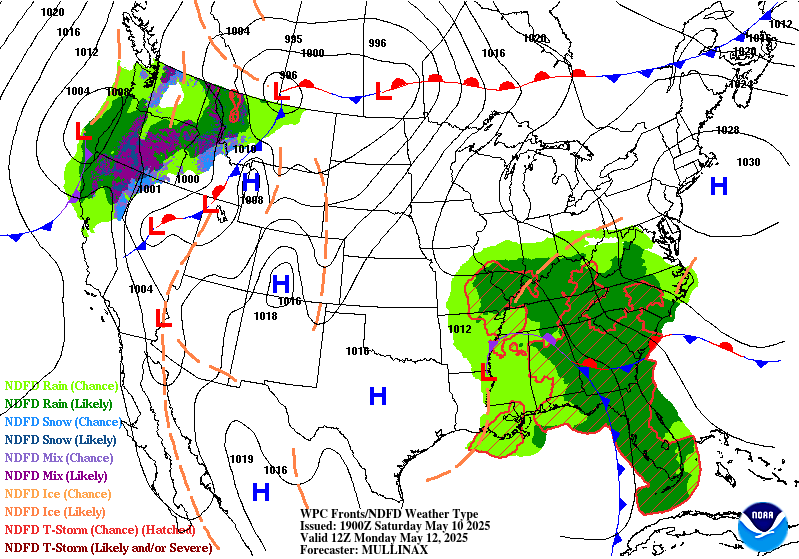
...THERE IS A SLIGHT RISK OF EXCESSIVE RAINFALL OVER PORTIONS
OF THE SOUTHEAST...
20Z Update: The primary change for the forecast was a general
expansion of the SLGT risk area further northeast into SC to
account for the heavier rainfall threat protruding inland given
the strong uni-direction component advecting rich Gulf moisture
poleward between the closed upper reflection over the Mississippi
Valley and the surface ridge over the Western Atlantic. Cold front
from the north will also hit a roadblock as it motions south,
likely becoming more quasi-stationary across North GA and the SC
Piedmont before being pushed back as a warm front. This will likely
coincide with a stronger low-level convergence signature up into
those areas by the afternoon and beyond on Sunday into Monday.
Considering the nature of the persistent moisture advection regime
and enhanced theta_E pattern, expecting widespread thunderstorm
development with rates likely reaching between 1-3"/hr within the
heaviest cores. Antecedent soil conditions should moisten with the
day prior, so the overlap will create a better threat for natural
runoff, not including the urban threat that is customary in these
setups. The previous SLGT risk was maintained with those expansions
to reflect the latest trends.
Kleebauer
..Previous Discussion..
A wave of upper level energy will pivot around the upper low across
the Southeast, sparking another wave of convection from the Gulf
Coast to the Southeast Atlantic Coast. Models are showing a more
organized area of surface low pressure moving into the Southeast
with significant rainfall totals on the eastern side. Widespread
totals of 1.5-2.5 inches are expected with locally high amounts
above 3 inches. Considering this will be the second day in a row
with heavy rainfall in the Southeast, areas with saturated soils
from the day before may be slightly more prone to flood impacts
with additional heavy rain on Sunday. The most favorable flash
flood conditions will be across North Florida and southern and
central Georgia where 1000+ J/kg MUCAPE and 30+ knots of effective
bulk shear with support organized convection. Additionally,
precipitable water values in excess of 1.5 inches will support
efficient rain rates in strong thunderstorms. A Marginal Risk area
is in effect for much of Alabama, Georgia, South Carolina, and
North and Central Florida, with an embedded Slight Risk area over
North Florida and southern and central Georgia.
Dolan
Day 3 threat area:
www.wpc.ncep.noaa.gov/qpf/99epoints.txt
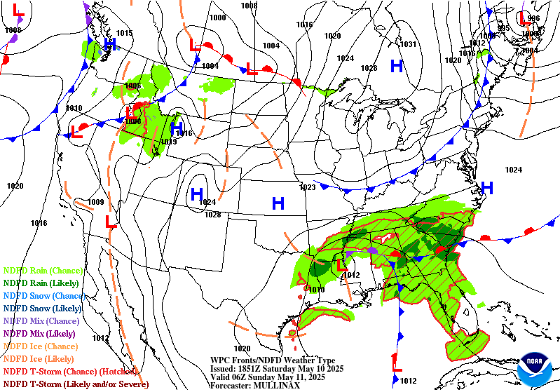
Extended Forecast Discussion
NWS Weather Prediction Center College Park MD
230 PM EDT Fri May 9 2025
The slow moving occluded surface low and associated upper low will
result in a strong influx of deep moisture from the Gulf and
western
Atlantic and result in multiple sustained rounds of moderate to
heavy rainfall extending from northern Florida to the Mid-Atlantic
region. In particular, enhanced moisture flux with upslope
component across the southern Appalachians on Monday (Day 4) will
likely result in higher rainfall totals across western SC/NC, and
there is the potential that a Moderate Risk area may be needed as
this event enters the short range forecast period. However, for the
time being, a Slight Risk area still remains valid from
southwestern Virginia to the northern Florida Peninsula, and a
Marginal Risk area across much of North Carolina into the Mid-
Atlantic for Tuesday (day 5), lingering into Wednesday, as the
moisture plume slowly works its way north while slowly weakening.
Out West, rain and higher elevation snows will become more
widespread into next week with the amplified upper low passing
through. This especially holds true for the Sierra early and into
the northern Rockies going into the middle of next week with some
of the higher ranges picking up enhanced late season snowfall. As
the system progresses east, moderate to locally heavy rainfall may
develop on the north and west side of a surface low over the north-
central Plains, but for the most part not expected to be heavy
enough to warrant any excessive rainfall risk areas at this time,
but will be monitored.
An early season heatwave is likely across the Dakotas and into
Minnesota early in the week as this region will be in the warm
sector of a developing surface low. Temperatures will be the
warmest of the season thus far with highs reaching the upper 80s to
potentially middle 90s, and easily setting some daily record highs.
It will also be hot across much of Texas with some 100+ degree
readings expected near the Rio Grande. Warmer temperatures are also
coming to much of the Eastern U.S. by the end of the week, with
humidity levels also increasing. In contrast, unseasonably cool
and unsettled conditions are forecast for the Intermountain West
with the amplified upper trough moving in, with highs running
10-20 degrees below mid-May averages in some cases.
Hamrick/Schichtel


