Excessive Rainfall Discussion
NWS Weather Prediction Center College Park MD
840 PM EDT Wed May 7 2025
Day 1
Valid 01Z Thu May 08 2025 - 12Z Thu May 08 2025
...THERE IS A MARGINAL RISK OF EXCESSIVE RAINFALL FOR PORTIONS OF
THE NORTHEAST FLORIDA COAST...
Previous MRGL risk across the Southeast has decreased in size with
a more focused area across Northeast FL where low-level convergence
along a quasi-stationary front draped over the region has allowed
for a repeating thunderstorm setup south of the Jacksonville metro.
Recent mesoanalysis indicates a sharp theta_E gradient within the
corridor mirroring the front with mean flow aligned parallel to the
boundary. SBCAPE between 1000-1500 J/kg is located within the
bounds of the area of interest with much of the convective
redevelopment occurring on the western flank of a passing mid-level
perturbation that is currently situated over the region. As the
energy wanders east, we'll see a sharp cut off the convective
threat with the remainder of the activity weakening due to lack of
sufficient forcing aloft, as well as the loss of diurnal heat
flux. This is a short term issue with the first 2-4 hrs. being the
primary time frame of interest before conditions improve overnight.
FFG's are thankfully very high within each 1/3/6 hr. intervals
(4/5/6 inches) respectively for each exceedance marker, so not
anticipating much outside a threat for isolated flash flooding,
mainly within the confines of I-95 between Jacksonville to Saint
Augustine.
Across the Mid-Mississippi Valley, a meander ULL will contribute to
widespread showers and elevated convective concerns overnight
culminating in a small axis of heavier precip across the east-
central portion of MO where low to mid-level convergence and deeper
moisture profiles will be present. Despite the better alignment for
heavier precip, the maximum rate potential is capped due to the
lack of an anomalous PWAT presence that typically is necessary this
time of year for higher impacts. An isolated flash flood threat is
still plausible across the area extending along and south of I-70
from Jefferson City across to St. Louis and north of the Ozarks of
Southeast MO. The threat is non-zero, but under 5% for the
necessary risk threshold, so decided to maintain a nil, but make
mention of the very low-end potential where total rainfall will
likely reach between 1-2", but rates will be lacking for sufficient
flash flood concerns.
Kleebauer
Day 1 threat area:
www.wpc.ncep.noaa.gov/qpf/94epoints.txt
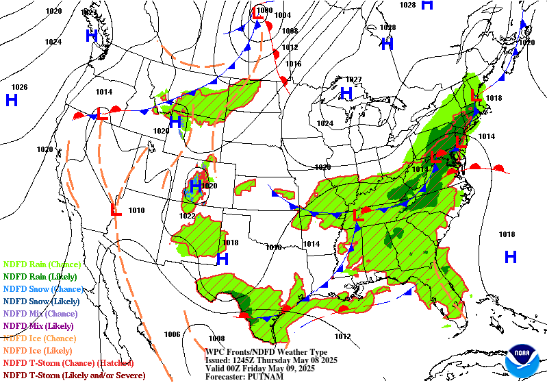
Excessive Rainfall Discussion
NWS Weather Prediction Center College Park MD
840 PM EDT Wed May 7 2025
Day 2
Valid 12Z Thu May 08 2025 - 12Z Fri May 09 2025
...THERE ARE SLIGHT RISKS OF EXCESSIVE RAINFALL OVER PORTIONS OF
THE CENTRAL GULF COAST & THE NORTHEAST...
...Central Gulf Coast & Southeast...
21Z update... The environment will be primed for scattered to
widespread convection capable of producing rainfall rates of 0.50
inch/hr or higher. There is a decent amount of variance within the
guidance on where the higher amounts are expected to occur however
there was a notable decrease in amount for portions of the Lower
Mississippi Valley while an increase across parts of the Tennessee
Valley/Appalachians/Southeast. The Marginal Risk area was trimmed
out of much of the Lower Mississippi Valley and increased to cover
much of Kentucky and western portions of Virginia, North Carolina,
South Carolina and Georgia.
Campbell
The stalled front draped north of the Gulf Coast will continue to
act as a trigger for additional thunderstorms on Thursday. In
addition to what is still a moist air-mass for early May, there
will be the added assistance of an approaching positively-tilted
500mb trough to provide additional upper-level support. The central
Gulf Coast remains most susceptible to flash flooding given their
closer positioning to a >400 kg/m/s IVT and PWs above 1.75". These
favorable atmospheric parameters are on top of what are now highly
sensitive soils following multiple days worth of heavy rainfall.
The Slight Risk remains in place over a small section of the
Central Gulf Coast, while the expansive Marginal Risk that
stretches from the Ozarks to as far east as the Southeast coast
still looks to be in good shape given the dearth of moisture in
place ahead of the approaching cold front and sufficient
instability (MLCAPE between 500-1,500 J/kg). The FL Space Coast is
also at risk for flash flooding given the similar setup to
Wednesday and potential for more saturated soils following any
thunderstorm activity on Wednesday. Localized flash flooding is
possible, most notably in the region's more urbanized communities
and where PWs are highest.
...Deep South Texas...
21Z update... Environment described below still expected so no
major changes made for this issuance.
Campbell
A strong cold front pushing south out of central Texas will meet
up with Gulf moisture, resulting in scattered thunderstorms across
the area. These storms will have the benefit of a dual-jet streak
setup aloft which when combined with the approach of a 500mb
shortwave trough will help support thunderstorm clusters into
Thursday night. Low-level easterly winds should lead to
thunderstorm development over the Davis Mountains that could then
propagate SE towards the Rio Grande Valley. With mean wind flow
out of the west, any storms that may form over the Sierra Madre
could also approach the Rio Grande River Thursday evening. As these
initial round of storms generate cold pools, these new cold pools
will invigorate additional clusters of storms Thursday night. Most
areas will see at least some period of heavy rain, which will be
capable of causing isolated instances of flash flooding.
...Northeast...
21Z update... The latest WPC QPF and model trends had a small
uptick in QPF, particularly in the northeast
Pennsylvania/northwest New Jersey/southeast New York corridor.
With this increase the SLight Risk was adjusted further east across
northwest New Jersey. The Marginal Risk saw a minor southward
expansion across northern Virginia.
Campbell
A complex upper-level evolution will begin on Thursday over the
Northeast that is trending towards a more wet and stormy setup
across the Northeast. An anti-cyclonic wave break over southeast
Canada is splitting a lobe of the positively-tilted upper trough over
southern Ontario into a cut-off low by Thursday night. Guidance
remains split on how far west the blossoming shield of
precipitation will advance, but most guidance is coming into a
consensus on a swath of the Northeast that stems from central PA
and the southern tier of NY on east into areas just west of I-95.
The area of greatest concern lies in northeast PA and into the
Catskills where soils have grown exceptionally sensitive over the
past several days thanks to multiple rounds of heavy rainfall.
As the upper low deepens Thursday night, strong 200-500mb upper
level divergence will work in tandem with strengthening 850-700mb
FGEN and WAA to generate an axis of heavy rainfall. Soundings
between 06-12Z Fri show highly saturated profiles and warm cloud
layers as deep as 9,000ft deep closer to I-95. As of this
discussion, 6-hr FFGs were as low as 1.00" along the northeast
PA/NY state borders. While some recovery is expected, this
highlights that it may not take much more than one inch of rainfall
in 6 hours to cause flash flooding. For these reasons, a Slight
Risk was introduced over parts of the Poconos and Catskills where
there is a decent compromise for higher QPF and where soils are
most sensitive.
Mullinax
Day 2 threat area:
www.wpc.ncep.noaa.gov/qpf/98epoints.txt
Excessive Rainfall Discussion
NWS Weather Prediction Center College Park MD
840 PM EDT Wed May 7 2025
Day 3
Valid 12Z Fri May 09 2025 - 12Z Sat May 10 2025
...THERE IS A SLIGHT RISK OF EXCESSIVE RAINFALL OVER PORTIONS OF
THE CENTRAL GULF COAST...
...Gulf Coast & Southeast...
21Z update... The latest guidance and WPC QPF shifted the focus
from far southeast Louisiana to the South Carolina/Georgia coast
with the greatest amounts from the vicinity of the Mobile metro and
across the Florida Panhandle. The Slight Risk area now spans from
about Panama Beach to about Biloxi, Mississippi. The Marginal Risk
covers southeast Louisiana to southern Carolina and south towards
Melbourne, Florida.
Campbell
An amplifying and large upper low positioned over the Lower MS
Valley will linger over the region through Friday night with heavy
rainfall likely from the central Gulf Coast to the Southeast coast.
Latest trends in guidance has been to sharpen up a 500mb low over
the Lower MS Valley. The ECMWF SATs page shows an IVT >400 kg/m/s
which is above the 90th climatological percentile. Soundings in the
region also show highly saturated profiles, modest instability,
and deep warm cloud layers. This combined with sufficient vertical
wind shear to help sustain areas of organized thunderstorms is
increasing the threat for Excessive Rainfall over the central Gulf
Coast and FL Panhandle. This setup remains fluid given the recent
trends in guidance to be wetter over the central Gulf Coast, with
the EC- AIFS and GFS GraphCast showing similar trends. Given the
growing soil sensitivities in the central Gulf Coast, the latest
Day 3 ERO update now includes a Slight Risk. The more urbanized
swath of the I-10 corridor is most at-risk for potential flash
flooding on Friday.
...Northeast...
21Z update... No change to the Marginal Risk.
Campbell
The upper-low evolution stated in the Day 2 discussion holds true
for Friday but unlike Day 2 when the heavy rain threat is confined
to a 6 to at most 12 hour window, the Excessive Rainfall threat
will impact not just the daytime hours on Friday but into Friday
night. Out ahead of the upper low, guidance is showing a
strengthening IVT surpassing 500 kg/m/s off the Northeast coast
that will transport copious amounts of moisture into the Northeast.
Moisture will wrap around the northern flank of the 500mb low into
northern NY and central New England. Farther east, the warm sector
will feature highly saturated and deep warm cloud layers that could
contain some weak elevated instability. There remains some spread
in where the axis of heaviest rainfall sets up, which is why a
Slight Risk was not issued as of this forecast cycle. However,
given trends in guidance are all pointing towards a cut-off low
over the Northeast and soils throughout the region are highly
sensitive, there may be the need for a Slight Risk upgrade in
future forecast updates once confidence increases in where the
heaviest rainfall takes shape.
Mullinax
Day 3 threat area:
www.wpc.ncep.noaa.gov/qpf/99epoints.txt
Extended Forecast Discussion
NWS Weather Prediction Center College Park MD
217 PM EDT Wed May 7 2025
A wavy frontal system and a closed upper low meandering over the
Southeast will continue to support a multi-day heavy
rainfall/runoff threat into next week as fueled by the pooling of
highly anomalous moisture. Relatively dry antecedent conditions
and higher flash flood guidance may limit the overall flash
flooding potential, at least initially. For now, opted to maintain
WPC Excessive Rainfall Outlook Marginal risks for Days 4/5
this weekend, especially considering lingering uncertainty in the
details/local focus. However, repeat cells/training along with
subsequent cumulative effects from prior days will likely lead to
threat level upgrades as the supporting guidance signal continues
to increase closer to the wet event. Rainfall may gradually lift
northward with time into the Mid-Atlantic early-mid next week.
Elsewhere, rainfall will be exiting the Northeast after Saturday
with the upper low. Out West, rain and higher elevations snows will
become more widespread through the weekend and become more
widespread with main amplified system cooling and slow progression
inland through early and mid next week.
General troughing across the South will keep temperatures near or
below normal at least through the weekend and longer for the
Southeast. Upper ridging out West will support much above normal
temperatures with daytime highs 20-25+ degrees above normal in the
Northern Plains. Above normal temperatures may also extend across
the Upper Midwest/Great Lakes/Northeast by next week. Parts of the
Southwest should approach 100 degrees with at least some localized
heat threat given earlier in the season timing. The WPC Hazards
Outlook continues to depict a weekend Hazardous Heat Threat area.
Santorelli/Schichtel


