Excessive Rainfall Discussion
NWS Weather Prediction Center College Park MD
851 PM EDT Sat May 10 2025
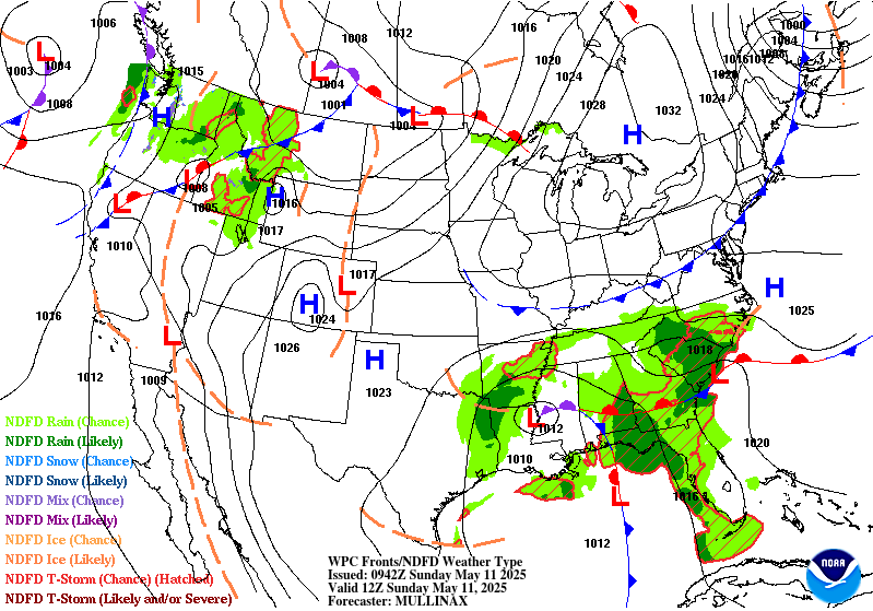
Day 1
Valid 01Z Sun May 11 2025 - 12Z Sun May 11 2025
...THERE IS A SLIGHT RISK OF EXCESSIVE RAINFALL OVER PORTIONS OF
THE FLORIDA PANHANDLE AND SOUTHEASTERN ALABAMA...
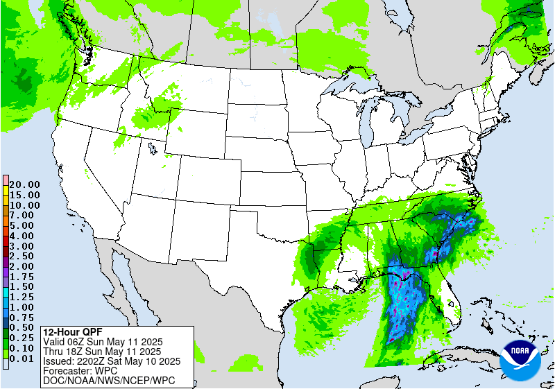
Backbuilding cells are resulting in an isolated flash flood risk
over central AL. Probabilities of 1" an hour rainfall drop off
steadily this evening in both the 18z HREF and REFS over this
region, and thus expect this flood risk to be on a decline as well.
A localized flash flood risk will continue across portions of
central to southeast GA into tonight. Convection will continue to
move off to the northeast across this region, with some occasional
backbuilding into the southerly low level inflow locally enhancing
rainfall totals. Localized rainfall over 3" could result in
isolated flash flood concerns. By 06z-12 tonight some signal for
possible backbuilding convection along the SC coast. The 23z HRRR
outputs 3"+ amounts along coastal areas, with some 5"+ amounts just
offshore. However it should be noted that HRRR run to run
continuity over this area is low, suggesting low predictability.
Both the 18z HREF and REFS neighborhood probability of exceeding 3"
across this area are in the 20-30% range. Thus, while something to
keep an eye on later tonight, confidence in convective evolution
is low and not currently anticipating anything more than an
isolated flash flood threat.
The Slight risk was maintained for portions of the FL Panhandle
into southeast AL. Overall probably a lower end Slight risk,
however recent rainfall has increased soil saturation and another
round of convection later tonight could thus result in an isolated
to scattered flash flood risk. Recent HRRR runs, the 18z HREF and
18z REFS all indicate an uptick in convection moving onshore into
the FL Panhandle into southeast AL by late tonight into Sunday
morning. The organization and intensity of this activity remains
uncertain, but the neighborhood probability of 1"/hr rainfall in
both the 18z HREF and REFS increases towards 50% by 12z, with 2"/hr
probs closer to 20%. Typically would associate these values more
with a Marginal risk, however given the likelihood of additional
convection falling over areas that have already seen heavy rain,
prefer to maintain continuity at this time...thus the Slight risk
will remain.
Chenard
Day 1 threat area:
www.wpc.ncep.noaa.gov/qpf/94epoints.txt
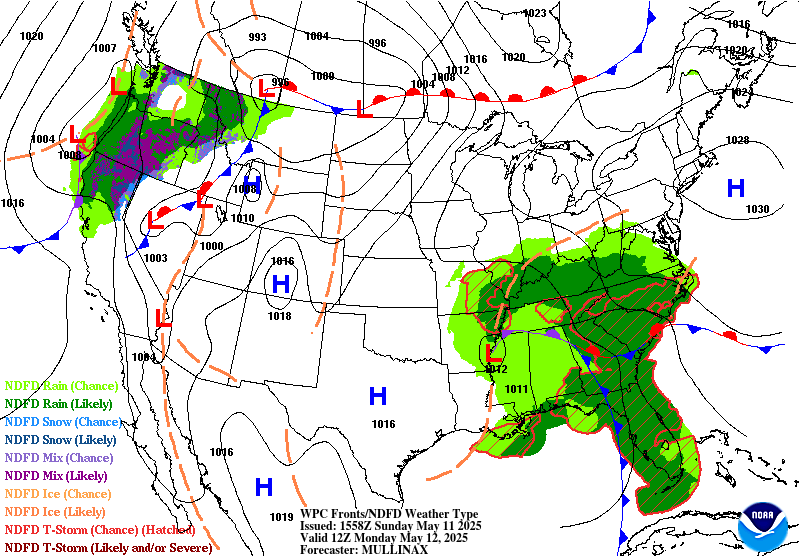
Excessive Rainfall Discussion
NWS Weather Prediction Center College Park MD
851 PM EDT Sat May 10 2025
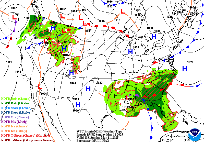
Day 2
Valid 12Z Sun May 11 2025 - 12Z Mon May 12 2025
...THERE IS A SLIGHT RISK OF EXCESSIVE RAINFALL OVER PORTIONS OF
THE SOUTHEAST...
...20Z Update...
A few changes were made to the ongoing Slight Risk area across the
Southeast for Sunday. In coordination with BMX/Birmingham, AL
forecast office, the Slight was expanded westward across much of
central Alabama in the expectation of additional heavy rains
wrapping around the northwest side of the upper level low over
Louisiana. In addition to rainfall today causing localized flash
flooding, the area has seen multiple days of heavy rains recently,
so the soils are near saturation and therefore likely to flash
flood with the expected 1-2 inches of additional rain expected
Sunday and Sunday night, though localized totals from thunderstorms
will be higher.
The other update was to expand the Slight Risk to include all of
the South Carolina coast with this update. The Carolinas will be on
the "warm" side of the system so abundant Gulf moisture will be
drawn north, supporting training thunderstorms at times across all
of the South Carolina coast. Including the lighter rains the area
is seeing right now, soils will be saturated more quickly with the
additional rainfall Sunday through Sunday night.
The surrounding Marginal Risk was nudged northward in North
Carolina as well as into Arkansas and Tennessee around Memphis. A
narrow area of training showers and storms is probable across
northern Mississippi, western Tennessee and eastern Arkansas.
However, given the lack of moisture overall, especially as
compared with areas further east, expect that rainfall rates will
not be high enough to cause anything more than isolated flash
flooding, despite somewhat saturated soils in that area. The
forecast will be monitored for a possible Slight Risk issuance
around Memphis with future updates.
Wegman
...Previous Discussion...
The upper level low over the Central Gulf Coast will elongate
north-south as another upper level wave of energy moves over the
Southeast on Sunday, and the direction of the mean layer flow will
shift to become more directly onshore/perpendicular to the Gulf
Coast. Meanwhile, a strengthening southern stream jet will create
favorable divergence aloft in the left exit region positioned right
over North Florida and southern Georgia in the afternoon/evening.
At the surface, an occluded low pressure system will be very slowly
moving north across the Southeast with a stationary front
extending west to east across Georgia and South Carolina. This
setup will support another wave of widespread showers and
thunderstorms capable of producing heavy rain. Much of the region
will have received heavy rain the day before (Saturday), resulting
in more saturated soils that are potentially easier to flood.
There is good agreement among models of widespread 2-3 inch totals
through the period for North Florida and southern and central
Georgia, with locally higher amounts up to 4+ inches possible. Hi-
res CAMs (available through the first half of the period) suggest
that storms developing Sunday afternoon will have the potential to
produce rain rates of 2+ inches per hour. Given the moist, unstable
air mass in place, some stronger/deep thunderstorms will be
possible as well that could contribute to rain rates exceeding the
1 and 3 hr FFGs of 3-4 inches. Some global models (mainly the ECMWF
and CMC) are suggesting high moisture pushing even further inland
with rainfall totals of 2-4 inches potentially reaching into
western North Carolina along the upslope region of the southern
Appalachians. Some heavy rainfall potential will also exist across
portions of Mississippi and Alabama where showers and storms may
develop in the vicinity of the surface low pressure center. A broad
Marginal Risk is in place from northern Mississippi through much of
Alabama to South Carolina and western North Carolina and for
portions of Central Florida. There is an embedded Slight Risk area
for North Florida, southern and central Georgia, and portions of
eastern Alabama and southern South Carolina, which covers areas
with the highest rain rate/flash flood potential.
Dolan
Day 2 threat area:
www.wpc.ncep.noaa.gov/qpf/98epoints.txt
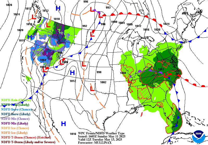
Excessive Rainfall Discussion
NWS Weather Prediction Center College Park MD
851 PM EDT Sat May 10 2025
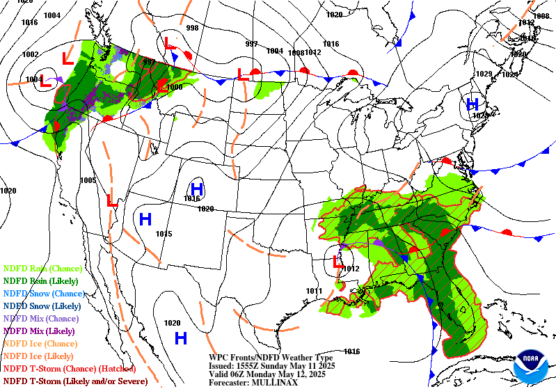
Day 3
Valid 12Z Mon May 12 2025 - 12Z Tue May 13 2025
...THERE IS A SLIGHT RISK OF EXCESSIVE RAINFALL OVER PORTIONS OF
THE SOUTHEAST AND SOUTHERN MID-ATLANTIC...
...20Z Update...
With increasing amounts of rainfall across the Southeast in the
forecast, the Slight Risk area was expanded in all directions with
this update.
Most notably, portions of western North Carolina and far southern
Virginia are very close to needing a Moderate Risk upgrade.
Increasing rainfall, likely training, and abundant influx of
Gulf/Atlantic moisture into the east facing slopes of the southern
Appalachians may impact areas hard hit from Hurricane Helene last
September. Thus, with some sensitivity in that area to prolonged
rains, including embedded heavy rains, the area may need that
upgrade with coming updates. For now there remains some uncertainty
as to where training lines of storms will set up relative to the
most impacted areas, as it may take prolonged heavy rain, rather
than long duration light to moderate rain, to cause flooding
impacts. For this reason the Moderate was skipped for now.
A small northward trend was noted in the guidance, leading to more
rainfall into the Appalachians and Piedmont of southern Virginia.
The Slight Risk was expanded north with this update to the
Shenandoah Valley, as well as into the Richmond metro.
Down south, in coordination with MFL/Miami, FL Forecast office, the
Slight Risk was expanded south along the coast through Miami.
Stationary thunderstorms are likely along the sea breeze and a
stalled front in that area. Should these storms form over the
urbanized I-95 corridor, flash flooding is likely as a result.
The Slight was expanded west to the Atlanta Metro due to long
duration repeating rounds of rain expected to move over the city.
The Marginal Risk was expanded well to the west into Arkansas for
another day of widely scattered but potentially training
thunderstorms.
Wegman
...Previous Discussion...
The upper low that will impact the Southeast over the weekend will
finally gain some momentum and move north towards the Tennessee
Valley on Monday. The accompanying surface low pressure system will
slowly drift north as well, and moisture ahead of the system will
expand from the Southeast into the southern Mid-Atlantic. Very high
PWAT values of 1.5-2 inches will spread up the Southeast Atlantic
Coast, and widespread heavy rain is forecast from Florida to
Virginia.
Inland areas in the upslope region of the Appalachians have lower
FFGs in the rage of 2.5-3 inches per 6 hours while FFGs elsewhere
are a bit higher at 3-4+ inches per 6 hours. The synoptic setup
with prolonged onshore flow from the Atlantic will favor enhanced
rainfall along the southern Appalachians, which is observed in
model output from all available global models. There will be a high
chance for 2-3 inches of rain, with potential for up to 4 inches,
from northern Georgia to southern Virginia, which would likely
cause at least scattered flash flooding concerns. High rainfall
totals will also be possible in convergent areas along the coast
from Florida to North Carolina, and 24 hour QPF totals are forecast
to reach 1.5-2 inches with locally higher amounts expected with
stronger convection. Many areas from Florida to South Carolina will
have already received heavy rain over the weekend, which will
increase the chance of flash flooding concerns with additional
heavy rain on Monday. There is a fairly large Slight Risk area in
place to cover the higher rainfall potential from Central and North
Florida through eastern Georgia and the Carolinas to southern
Virginia. The highest risk area within this region will be the
southern Appalachians, which will need to be monitored in future
forecast updates for potential ERO upgrades. Surrounding the Slight
Risk area, a Marginal is in place from Florida to Virginia.
Dolan
Day 3 threat area:
www.wpc.ncep.noaa.gov/qpf/99epoints.txt
Extended Forecast Discussion
NWS Weather Prediction Center College Park MD
300 PM EDT Sat May 10 2025
The slow moving occluded surface low and associated upper low will
result in a strong northward influx of deep moisture and result in
multiple sustained rounds of moderate to heavy rainfall extending
from northern Florida to the Mid-Atlantic region. In particular,
enhanced moisture flux with upslope component across the southern
Appalachians on Tuesday (Day 4) will likely result in higher
rainfall totals across central/eastern North Carolina northward to
central and western Virginia. Given low-mid level southeasterly
flow directed towards the Blue Ridge, some enhanced rainfall totals
will be possible here and the latest model guidance depicts this
scenario well. Some cells with hourly rainfall rates in excess of
an inch are likely, and therefore a Slight Risk area has been
introduced for Day 4. While the system will slowly weaken and
moisture
convergence lessens going into Wednesday (Day 5), the upper low
pattern
remains quite favorable for this time of year, so introduced a WPC
ERO Marginal Risk threat area the central Mid-Atlantic.
Out West, rain and higher elevation snows will become more
widespread into next week with the amplified upper low passing
through. This especially holds true for the northern Rockies going
into the middle of next week with some of the higher ranges
picking up enhanced late season snowfall, possibly over a foot in
some cases across southwestern Montana. As the system progresses
east, moderate to heavy rainfall may develop to the northwest of a
surface low over the Dakotas, and given the potential for some 1-2
inch rainfall totals on Wednesday, a Marginal Risk area is shown
for
the Day 5 period.
An early season heatwave is likely across the Dakotas and into
Minnesota early in the week as this region will be in the warm
sector of a developing surface low. Temperatures will be the
warmest of the season thus far with highs reaching the middle 80s
to lower 90s, which is at least 20 degrees above average for this
time of year and easily setting some daily record highs. It will
also be hot across much of Texas with some 100+ degree readings
expected near the Rio Grande. Warmer temperatures are also coming
to much of the Eastern U.S. by the end of the week, with humidity
levels also increasing. In contrast, unseasonably cool and
unsettled conditions are forecast for the Intermountain West with
the amplified upper trough moving in, with highs running 10-20
degrees below mid-May averages in some cases.
Hamrick/Schichtel


