Excessive Rainfall Discussion
NWS Weather Prediction Center College Park MD
337 PM EDT Thu May 8 2025
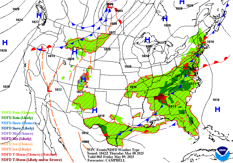
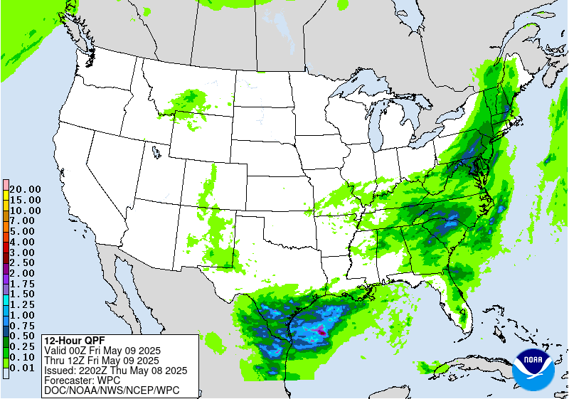
Day 1
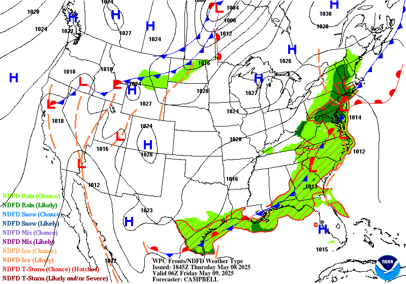
Valid 16Z Thu May 08 2025 - 12Z Fri May 09 2025
...THERE ARE A SLIGHT RISK OF EXCESSIVE RAINFALL OVER SOUTH TEXAS...
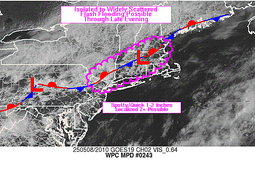
...Deep South Texas...
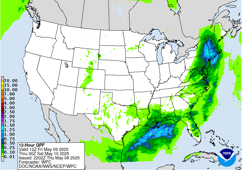
16Z Update: Little change with the overall expectations across Deep
South TX. Still looking at primary impacts from two rounds of
convection. The first is already occurring with a strong
thunderstorm slowly progressing eastward off South Padre as the
updraft and primary mesocyclone matured enough to drop a few inches
of rainfall in short succession along the South TX coast plain past
few hrs. 12z KBRO sounding came in with a deep moist profile with
PWATs settled at 2.15" putting it at the new 12z Daily Max for the
date. This is a testament to the environment available for any
convective regimes whether that be from more pulse variety
convection this morning and afternoon, and eventual MCS progression
as the potent shortwave ejects southeast out of MX generating a
more organized heavy rain prospect from the Big Bend, southeast.
12z HREF neighborhood probs for >3" are between 60-90% over the
area extending from CRP down to BRO to about 40 miles inland along
that stripe. Neighborhood >5" are highest near Brownsville to
McAllen (30-60%) lending credence to the higher flash flood threat
in the region, especially in those more urbanized corridors along
the Rio Grande Valley. The previous SLGT was relatively unchanged
considering the setup, in agreement with the local WFO's.
Kleebauer
..Previous Discussion..
A strong cold front pushing south out of central Texas will meet
up with Gulf moisture, resulting in organized thunderstorms that
are likely to form across the mountains of northeast Mexico and
move across the area. With 700 hPa temperatures around 9C, the
environment shouldn't be prohibitively capped, so there's little
reason to expect the storms to fade as they move through South TX.
Hourly rain amounts to 2.5" with local amounts to 5" are expected.
After coordination with the CRP/Corpus Christi TX and BRO/
Brownsville TX forecast offices, raised a Slight Risk for the
region.
Roth
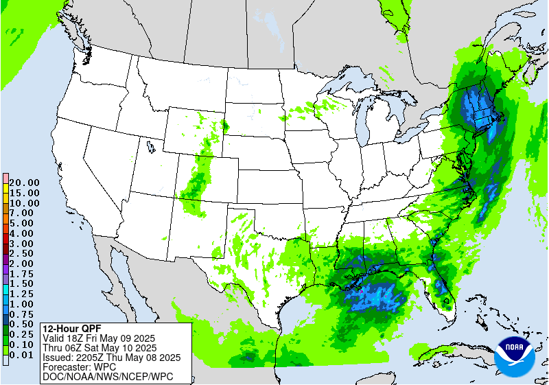
...Central Gulf Coast & Southeast...
16Z Update: Only minor changes were made for the inherited MRGL
risk across the Gulf Coast to the eastern FL Peninsula. Convective
pattern across the Central Gulf Coast will likely be tied to the
immediate coastal areas where the greatest convergence will align
with a frontal approach from the north coinciding with the remnant
stationary front positioned just off the LA/MS coast. The previous
MRGL was removed out of LA due to the threat likely to remain
either off the coast, or fall over the Southern Parishes south of
the urban corridor a bit further north. Southern Parishes are much
less prone to flash flood threats due to soil types and swamp
environments. Trends have focused away from the area of most
concern, so the MRGL risk was removed due to a non-zero, but sub-
threshold threat.
Across FL, thunderstorms will develop this afternoon along the sea
breeze with some anchoring influence over the Northeast FL coast
due to the presence of the stationary front. Rates will peak at
2-3"/hr max leading to more isolated flash flood concerns mainly
within the urban corridor along the Space Coast. Coverage of
thunderstorms will be scattered in nature leading to a more MRGL
risk for flash flooding when coupled with the expected magnitudes,
thus the previous risk was generally maintained.
Kleebauer
..Previous Discussion..
The stalled front draped north of the Gulf Coast will continue to
act as a trigger for additional thunderstorms on Thursday. In
addition to what is still a moist air mass, there will be the added
assistance of an approaching upper level trough to provide
additional divergence/support. The central Gulf Coast remains most
susceptible to flash flooding given their closer positioning to the
precipitable water values of 1.5-1.75". These favorable
atmospheric parameters are on top of what are now highly sensitive
soils following multiple days worth of heavy rainfall. The Slight
Risk was removed from southeast Louisiana where the QPF/recent
heavy rainfall pattern no longer overlaps, while the Marginal Risk
remains -- which shows some contraction -- given the precipitable
water values of 1.25-1.5" ahead of the approaching cold front and
sufficient instability (MLCAPE between 500-1,500 J/kg). The FL
Space Coast is also at risk for flash flooding given the similar
setup to Wednesday and potential for more saturated soils following
any thunderstorm activity on Wednesday. Localized flash flooding
is possible, most notably in the region's more urban areas.
Roth
...Northeast...
16Z Update: The previous SLGT risk inherited was downgraded due to
a bit of a degraded convective output from 12z CAMs and associated
HREF signaling a more isolated flash flood concern this afternoon
with the primary focus within the urban zones of Northeast PA and
Northwest NJ. Cold front progression is slowly sinking south with
small theta_E ribbon bisecting the above area aligning with a
stalled boundary in place. Once the cold front approaches and mid-
level ascent pattern builds within the LER of an approaching speed
max to the south, expecting scattered convection to initiate across
Northeast PA with mean storm motions pushing any activity in
Northern NJ and the Lower Hudson of NY. Activity will be slower
moving in general which does favor the flash flood prospects in one
regard, but the deterrent for anything appreciable is the limited
deep layer moisture to work with as the PWAT anomalies are running
pretty normal for the time of year. HREF hourly probs for >1"/hr
are highest (30-50%) over a short window between 18-23z before the
setup shifts and we begin to focus more on the evolving surface
cyclogenesis pattern to the south that will usher more
precipitation into the region. This scheme will be more stratiform
in nature with some embedded thunder possible across the Mid-
Atlantic up to around I-80 latitude. Some areas that see convective
threat earlier in the day will see more rain overnight, so some
initial priming could allow for a localized flood threat overnight,
but the lack of a true convective element will likely yield more
low-end potential than anything else.
In coordination with the local WFO's that were previously within
the SLGT, the risk was dropped with a solid MRGL remaining for the
dual threat this period with emphasis on what occurs this afternoon
and early evening.
Kleebauer
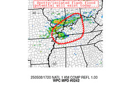
...Ohio Valley...
Slow-moving shortwave trough over the Mid-Mississippi Valley will
wander eastward through the Ohio Valley promoting scattered showers
and thunderstorms from MO all the way towards WV through the
period. 12z HREF neighborhood probs for >2" of rainfall is
actually pretty robust (>60%) in a corridor extending from St
Louis to Louisville down to around Paducah. The key in all this is
the matter of timing for all of this precip to fall with the
majority of hourly rates likely capped ~1"/hr at peak intensity.
Normally a MRGL risk wouldn't be considered for this type of
threat, but moist antecedent soils for a large part of the Ohio
Valley lean this closer to the MRGL risk. This helped maintain
continuity with the isolated threat encompassing the area between
I-70 to I-40 between the Mississippi River, east into WV.
Kleebauer
Day 1 threat area:
www.wpc.ncep.noaa.gov/qpf/94epoints.txt
Excessive Rainfall Discussion
NWS Weather Prediction Center College Park MD
337 PM EDT Thu May 8 2025
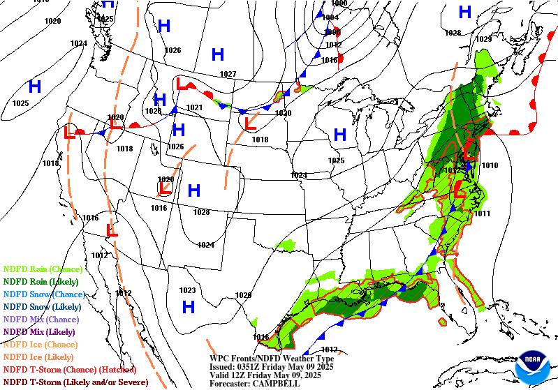
Day 2
Valid 12Z Fri May 09 2025 - 12Z Sat May 10 2025
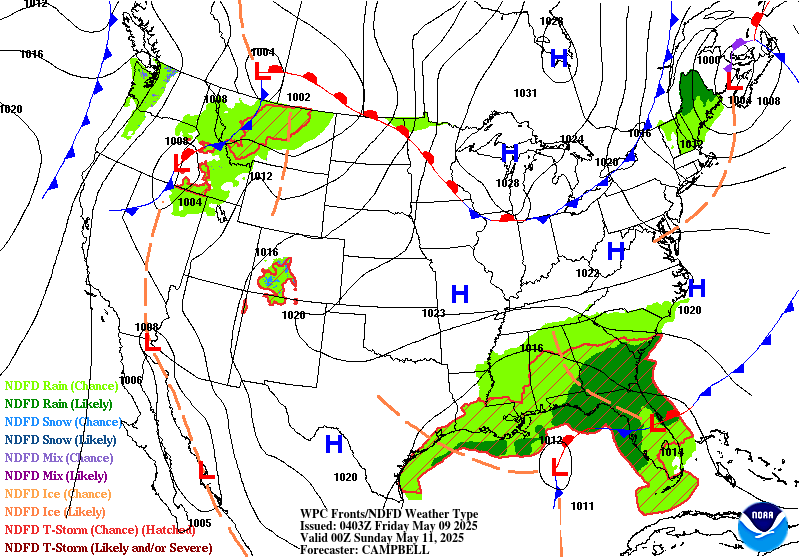
...THERE IS A MARGINAL RISK OF EXCESSIVE RAINFALL OVER PORTIONS OF
THE NORTHEAST & SOUTHEAST...
20Z Update: The period remains pretty consistent in run to run QPF
variance with the general convective threat across the
Southeastern U.S. still anticipated with the main changes being the
positioning of local maxima. 12z HREF remained steadfast on its
probabilistic outputs with an elevated EAS probs for >1" located
across Southern MS/AL with lower probs elsewhere. The signal for
>2" is much lower (<10-20%) for anywhere within the area of
interest meaning guidance still has a wide variance in where the
strongest cells will materialize during the forecast cycle. The
antecedent conditions are most favorable across Southeast LA where
heavy rains in the prior periods have decreased areal FFG's to more
attainable exceedance values. The rest of the Southeast is pretty
much near normal for the 1/3/6 hr. FFG exceedance intervals leading
to a higher rate threshold necessary to exhibit flash flooding.
The best opportunity for a targeted upgrade will likely be within
that corridor from Southeast LA through Southern MS/AL just given
the location of highest theta_E's correlated with better upper jet
dynamics in the form of a jet coupling between the mid-latitude jet
trailing the cyclonic flow to the north and the southern jet
streak focused to the south.
Across the Northeast, total precip will remain firmly between 1-3"
thanks to maturing mid-latitude cyclone moving northward off the
Northeast coast with much of the Northern Mid Atlantic through New
England well positioned within the LER of a strengthening upper
speed max juxtaposed over the Central Mid Atlantic around the
trough base. The total precip and intra-hour rates ~1"/hr will be
the greatest factor for any flash flood prospects since the
majority of the precip will likely be within a stratiform scheme
during the peak of the event. Hi-res ensembles and overwhelming
global deterministic outputs are generally modest with the
anticipated rates over the most impacted areas. This is a stronger
case for river and small stream flooding which is the reasoning for
the widespread Flood Watch issuances and not so much the flash
flood variety. If there was an upgrade, it would likely be very
targeted within Southern New England where there is a better case
for elevated instability within the WCB process generally over
more urbanized zones. In any case, the threat is still within the
lower risk threshold and has merit with the D2 ML First Guess
Fields. The MRGL was relatively unchanged with a small expansion
into the Philadelphia metro to cover for recent QPF trends.
Kleebauer
..Previous Discussions..
...Gulf Coast & Southeast...
A large upper low positioned over the Lower MS Valley will linger
over the region through Friday night with heavy rainfall possible
from the central Gulf Coast to the Southeast coast. Precipitable
values of 1.5-1.75" are forecast, implying nearly saturated
soundings. Effective bulk shear could be sufficient to help
sustain areas of organized thunderstorms. There is wide variance in
the QPF output from the various pieces of guidance, and most of
the guidance isn't terribly wet, so have kept the excessive
rainfall risk level at Marginal.
...Northeast...
Out ahead of the upper low, guidance is showing strengthening
onshore flow which would transport copious amounts of moisture into
the Northeast. Moisture will wrap around the northern flank of the
500 hPa low into a potential comma head pattern across northern NY
and central New England. Farther east, the warm sector will
feature highly saturated and deep warm cloud layers that could
contain some weak elevated instability. There remains some spread
in where the axis of heaviest rainfall sets up, which is why a
Slight Risk remains un-added. However, given trends in guidance
are all pointing towards a cut-off low over the Northeast and soils
throughout the region are highly sensitive, there may be the need
for a Slight Risk upgrade in future forecast updates once
confidence increases in where the heaviest rainfall takes shape.
Roth/Mullinax
Day 2 threat area:
www.wpc.ncep.noaa.gov/qpf/98epoints.txt
Excessive Rainfall Discussion
NWS Weather Prediction Center College Park MD
337 PM EDT Thu May 8 2025
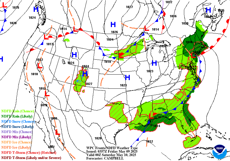
Day 3
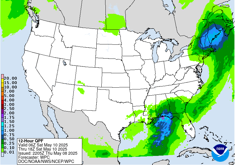
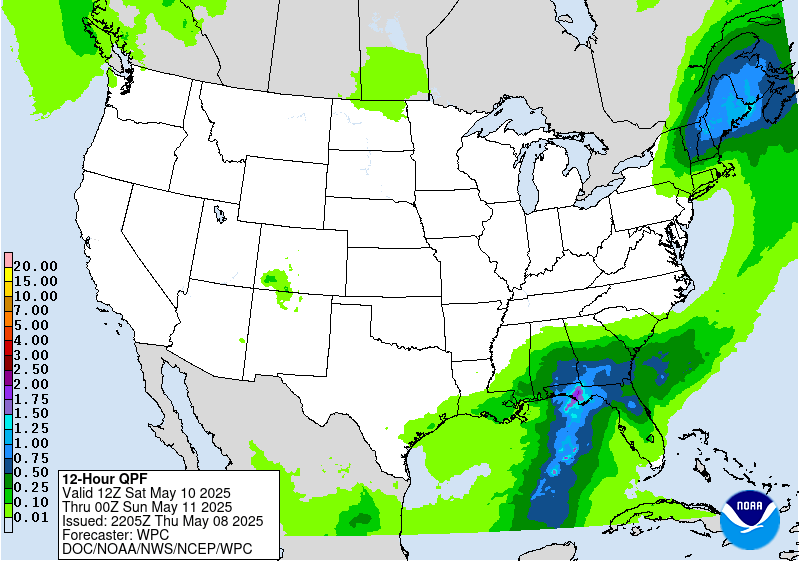
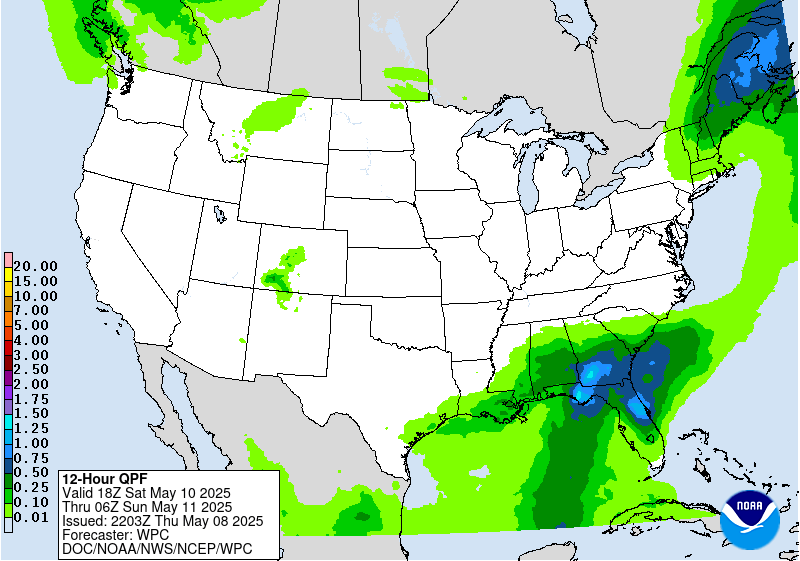
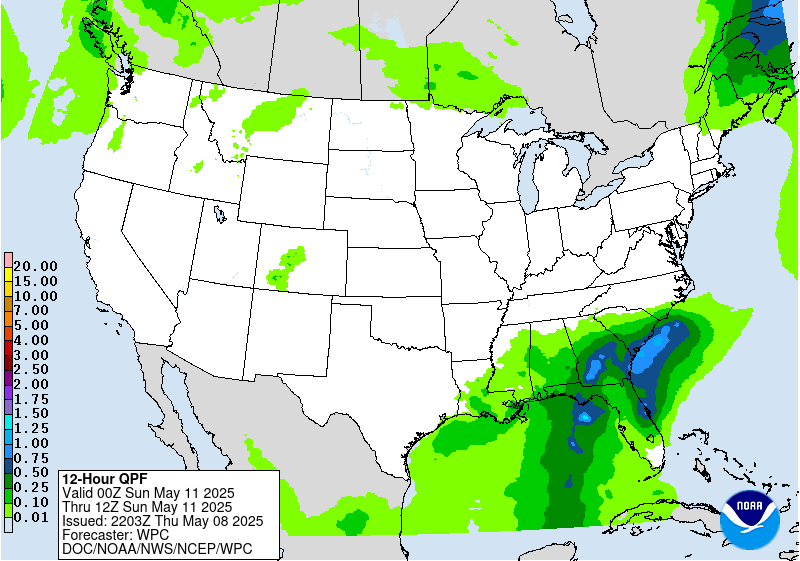
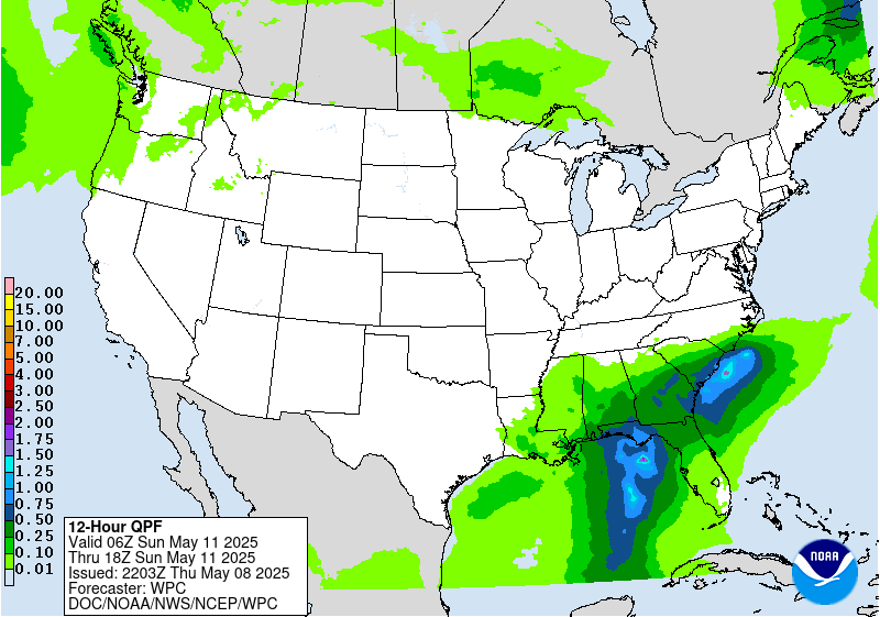
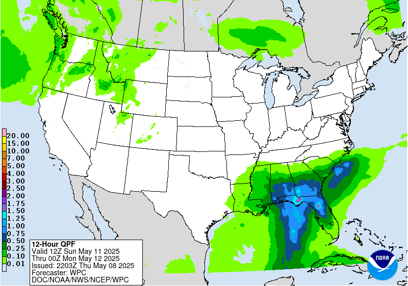
Valid 12Z Sat May 10 2025 - 12Z Sun May 11 2025
...THERE IS A MARGINAL RISK OF EXCESSIVE RAINFALL OVER PORTIONS OF
THE SOUTHEAST & NEW ENGLAND...
20Z Update: The main change this period was over the Northeastern
U.S. MRGL risk were the southern edge was pulled a bit northward
given the trends in QPF distribution. The ECMWF was one of the
furthest south in terms of the heavier QPF placement over the past
cycle of runs, however the ML disagreed with the assessment and had
the heavier precip further north as the the low will move steadily
northeast before occlusion. 12z ECMWF is now in line with the rest
of the deterministic and subsequent ensembles and ML output
leading to confidence in pulling the southern portion of the risk
area further north. As for the general pattern, little has changed
otherwise with the core of heaviest precip focused across ME where
precip is very much welcomed in all locales given current drought.
The MRGL risk was maintained due to the forecasted 1-2" rainfall
forecast with some terrain focused areas and urbanized zones the
most likely to see any hydro impacts.
Across the Southeast, beginning to see a greater consensus on
heavier precip entering near the Big Bend over Apalachicola
National Forecast, an area that is notoriously hard to flood
outside significant convective training and/or tropical influence.
Current moisture advection regime off the Gulf is situated for a
prolonged training threat within the eastern flank of the maturing
surface low positioned directly over the Central Gulf Coast. Deep
layer mean flow is progged to be due southerly across the entire
Western FL Panhandle which could ultimately lead to a targeted SLGT
risk issuance if the current setup stands. There's still a bit of
discrepancy on specifics with where the most prolific moisture
transport will end up, but ensemble and ML depictions are close to
that aforementioned area, but either a west or east displacement
would cause differences in potential impacts as some larger
population centers would get involved if the setup takes aim a bit
more upstream. The MRGL is in place currently, but would not be
surprised if a targeted upgrade is necessitated in future
forecasts, especially once in range of the CAMs.
Kleebauer
..Previous Discussion..
Southeast...
A cold low drops down to the Gulf coast with time, spurring a
development of a low vaguely near the Loop Current. Despite good
agreement aloft, there is a definite difference in the guidance in
lower levels, with the 00z NAM a bit north of the 00z GFS at 850
hPa. This sort of pattern usually leads to a semi-convective low
near the Loop Current which then moves northeast towards the
Florida Panhandle or Big Bend, though the low's approach to the
region looks more evident on Sunday or so/beyond the day 3 period.
Some of the guidance has a decent QPF signal near the FL Big Bend,
generally agreeing on 2-3" areal average, but it there is a bit of
dispersion. It appears the 850 hPa boundary is still down in the
Gulf much of the day. However, there could be enough moisture,
instability, and effective bulk shear for issues in northern FL.
For the moment, the Marginal Risk area remains in place due to the
dispersion seen in the guidance.
Northeast...
The guidance has a signal for moderate to heavy rainfall across
portions of New England over an area of relatively low flash flood
guidance values. This is near and ahead of a cold low racing
through the area. Precipitable water values rise to 1-1.25", which
given the cool 1000-500 hPa thickness values, should lead to
saturation. Given the strong 500 hPa height falls during the
afternoon hours, some instability is bound to be available. Added a
Marginal Risk area per the above. Per coordination with
CAR/the Caribou ME forecast office. left northern ME out as the
seven day rainfall across the state shows a fairly strong gradient,
with northern ME generally left out of the recent rainfall.
Roth
Day 3 threat area:
www.wpc.ncep.noaa.gov/qpf/99epoints.txt
Extended Forecast Discussion
NWS Weather Prediction Center College Park MD
300 PM EDT Thu May 8 2025
A wavy frontal system and a closed upper low meandering over the
Southeast will support a multi-day heavy rainfall and flooding
threat through next midweek as fueled by the pooling of highly
anomalous moisture. Given the increased signal for heavy rains by
Sunday (and some heavy rainfall potential starting on Saturday),
a Slight Risk for northern Florida and southern Georgia remains
depicted on the WPC Day 4 Excessive Rainfall Outlook (ERO). By
Monday, this potential expands southward into the Florida peninsula
and northward across much of the Southeast as storms may train
along a slow moving cold front lifting through the region. As such,
a slight risk is included for much of the Southeast on the Day 5
ERO as well. Protracted enhanced rainfall should gradually lift
northward with time increasing across the Mid-Atlantic and up the
Appalachians next Tuesday-Thursday before finally losing influence.
Out West, rain and higher elevations snows will become more
widespread through the weekend and into next week with main
amplified system cooling and slow progression inland through early
and mid next week. Modest snows are possible in the higher terrain.
As the system progresses east, moderate to heavy rainfall may
develop on the north and west side of a surface low over the north-
central Plains.
Upper troughing over the South will keep post-frontal temperatures
below normal through early next week, especially daytime maxes
given widespread and protracted rain/cloud potential around the
upper low. Upper ridging from the Southwest to the Plains will
support much above normal temperatures across much of the
intermountain West and northern U.S., with daytime highs 20-30
degrees above normal possible in the Northern Plains where record
values are in reach. Parts of the Southwest should exceed 100
degrees with at least some localized heat threat given earlier in
the season timing Sunday and Monday. Above normal heat will
moderate some as it progresses across the rest of the Plains and
into the Midwest and East next week. Upper troughing and frontal
surge over much of the West will drop and maintain temperatures
below normal Tuesday-next Thursday in unsettled flow.
Santorelli/Schichtel


