Excessive Rainfall Discussion
NWS Weather Prediction Center College Park MD
851 PM EDT Sat May 10 2025
Day 1
Valid 01Z Sun May 11 2025 - 12Z Sun May 11 2025
...THERE IS A SLIGHT RISK OF EXCESSIVE RAINFALL OVER PORTIONS OF
THE FLORIDA PANHANDLE AND SOUTHEASTERN ALABAMA...
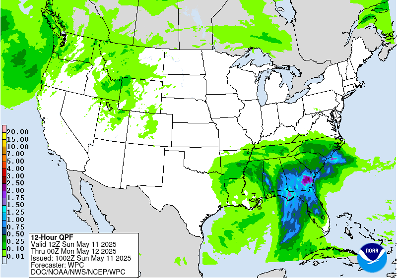
Backbuilding cells are resulting in an isolated flash flood risk
over central AL. Probabilities of 1" an hour rainfall drop off
steadily this evening in both the 18z HREF and REFS over this
region, and thus expect this flood risk to be on a decline as well.
A localized flash flood risk will continue across portions of
central to southeast GA into tonight. Convection will continue to
move off to the northeast across this region, with some occasional
backbuilding into the southerly low level inflow locally enhancing
rainfall totals. Localized rainfall over 3" could result in
isolated flash flood concerns. By 06z-12 tonight some signal for
possible backbuilding convection along the SC coast. The 23z HRRR
outputs 3"+ amounts along coastal areas, with some 5"+ amounts just
offshore. However it should be noted that HRRR run to run
continuity over this area is low, suggesting low predictability.
Both the 18z HREF and REFS neighborhood probability of exceeding 3"
across this area are in the 20-30% range. Th
Excessive Rainfall Discussion
NWS Weather Prediction Center College Park MD
339 AM EDT Sun May 11 2025
Day 1
Valid 12Z Sun May 11 2025 - 12Z Mon May 12 2025
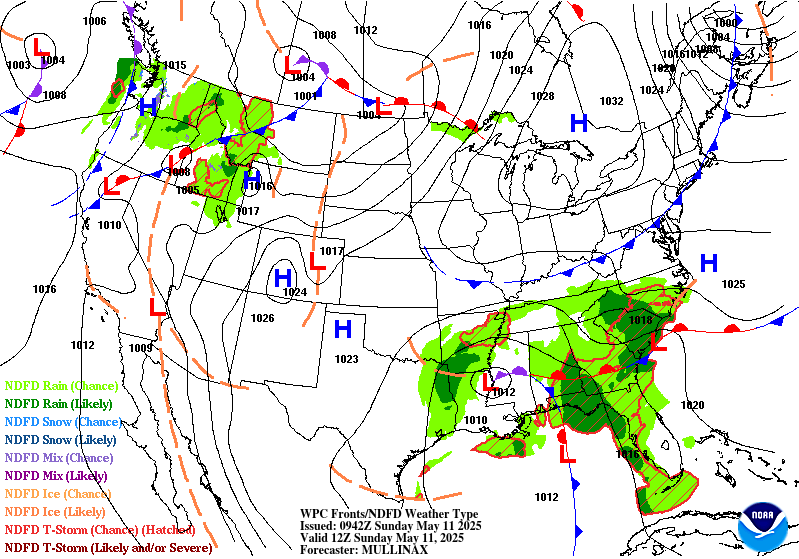
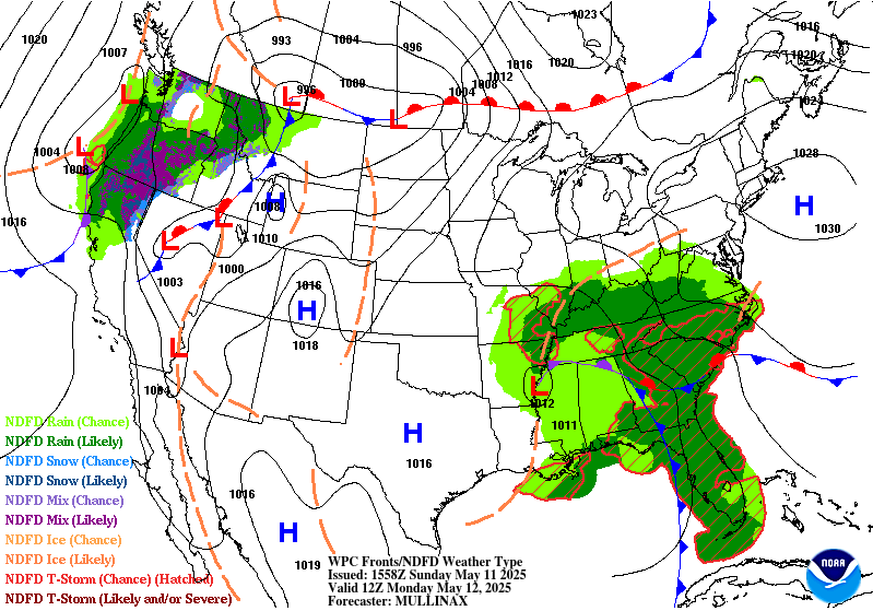
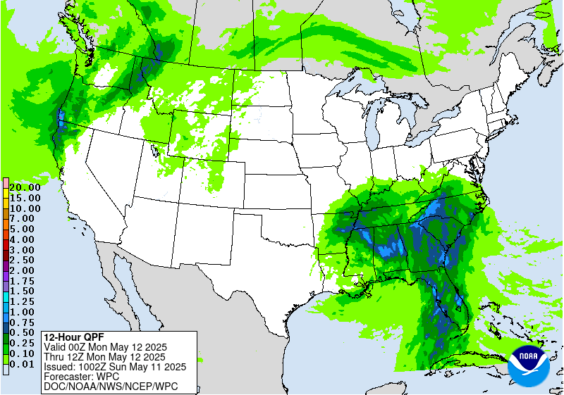
...THERE IS A SLIGHT RISK OF EXCESSIVE RAINFALL OVER MUCH OF THE
SOUTHEAST...
A stationary upper low will remain positioned over the Central
Gulf Coast today while waves of upper level energy pivot around it
over the Southeast. The low is expected to become slightly
elongated north to south, resulting in strong southerly mean flow
that will pump moisture from the Gulf directly into the Southeast.
Additionally, a southern stream jet is forecast to strengthen over
the northern Gulf, creating favorable upper level divergence over
North Florida and Georgia to support widespread shower and
thunderstorm development. At the surface, an occluded low pressure
system will be slowly moving north across the region, with a cold
front extending south across the Florida Panhandle and a stationary
front extending east across Georgia and South Carolina. The best
conditions for heavy rain will be in the warm sector over North
Florida and southern Georgia, but heavy rainfall will also be
possible along and north of the stationary boundary up into
portions of the Carolinas.
With plentiful moisture (PWATs 1.5-2+ inches) and instability
(MUCAPE 1500-2000+ J/kg), storms in the warm sector will be capable
of producing 2-3+ inch per hour rain rates from Florida to South
Carolina, which could lead to some flash flooding concerns given
2-3 inch per hour FFGs. Flash flooding may also be a concern back
into portions of Alabama and northern Mississippi where there will
likely be enough moisture and instability in the vicinity of the
surface low to produce showers and storms with 2+ inch per hour
rain rates. Previous heavy rains have already saturated soils from
Mississippi to Georgia, which will make these areas more sensitive
to flooding with additional heavy rain today. To account for this
flood potential there is a Slight Risk of excessive rainfall in
place for much of the Southeast, including areas from North Florida
to southern North Carolina and much of Alabama and northern
Mississippi. The Slight Risk area is encompassed by a broader
Marginal Risk that includes much of the Tennessee Valley, eastern
Arkansas, upslope regions of the southern Appalachians, and Central
Florida.
Dolan
Day 1 threat area:
www.wpc.ncep.noaa.gov/qpf/94epoints.txt
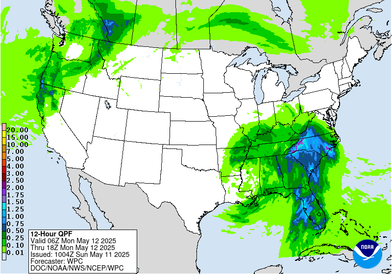
Excessive Rainfall Discussion
NWS Weather Prediction Center College Park MD
339 AM EDT Sun May 11 2025
Day 2
Valid 12Z Mon May 12 2025 - 12Z Tue May 13 2025
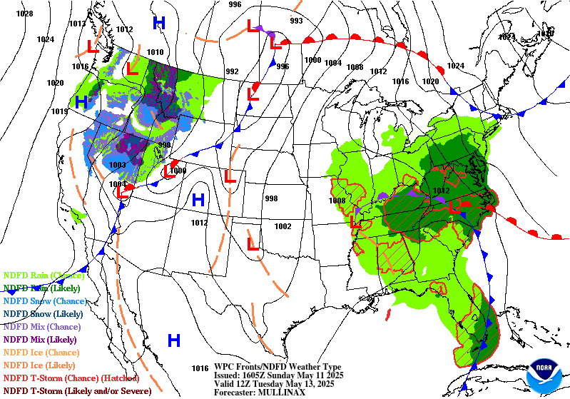
...THERE IS A SLIGHT RISK OF EXCESSIVE RAINFALL OVER PORTIONS OF
THE SOUTHEAST AND SOUTHERN MID-ATLANTIC...
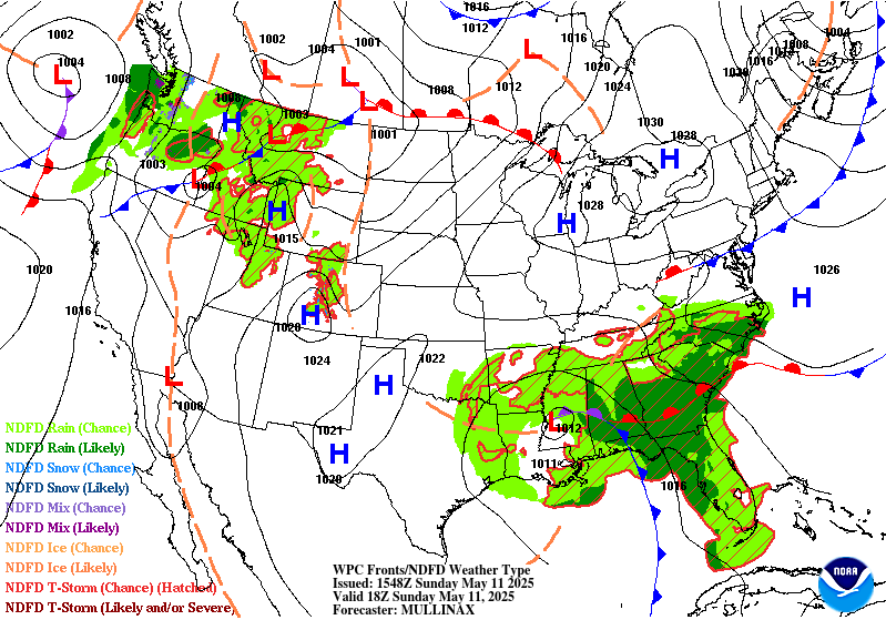
The nearly stationary upper low that impacted the Southeast over
the weekend will finally gain some momentum and shift north towards
the Tennessee Valley on Monday, pulling the surface low pressure
system along with it. The trailing cold front will gradually push
towards the Southeast Atlantic Coast while the warm front lifts
into the southern Mid-Atlantic, and another round of widespread
showers and storms are forecast Monday into Monday night in the
warm sector of the system. Deep moisture will surge north ahead of
the cold front, extending from Florida through the Carolinas to
southern and central Virginia. PWATs are anticipated to reach
1.5-2+ inches in these areas with even higher values possible over
the Florida Peninsula. Strong south-southeasterly mean flow will
remain in place, which will likely result in two convergent zones,
one along the Southeast Coast and one along upslope regions of the
southern Appalachians where high QPF totals will be possible.
Strong diurnal convection over the Florida Peninsula will also
contribute to high QPF values over portions of Central and South
Florida.
The largest flooding concerns will come with repeat/training
activity, which could result in high QPF totals over a relatively
short period of time, potentially reaching or exceeding the 1 and 3
hour FFGs in these regions. To account for this flash flood risk,
there is a Slight Risk area stretching from Florida up the
Southeast Coast to North Carolina and southern Virginia and also
for the upslope regions of the Appalachians from Georgia to
Virginia. A Marginal Risk area extends even further into the Mid-
Atlantic where moderate rain rates may contribute to localized
flash flooding and into the Tennessee and Mid-Mississippi Valleys
where enough moisture will likely wrap around the surface low to
create locally heavy rainfall in showers and storms.
Upslope regions of the southern Appalachians are particularly
sensitive to heavy rain, especially in areas that were impacted by
Hurricane Helene. Impacts from heavy rain on Monday will likely
fall into the high-end Slight Risk category, and ERO upgrades may
be needed in the future if high QPF trends hold,. However,
instability may be a limiting factor as the better instability is
expected to reside along the coast. After coordinating with local
forecast offices, it was decided to hold off on any upgrades at
this time. By this afternoon, the CAMs will go out far enough to
cover the entire Day 2 period and will likely give us a better idea
of the magnitude of potential flooding impacts.
Dolan
Day 2 threat area:
www.wpc.ncep.noaa.gov/qpf/98epoints.txt
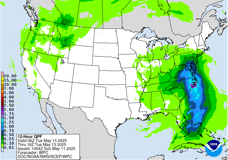
Excessive Rainfall Discussion
NWS Weather Prediction Center College Park MD
339 AM EDT Sun May 11 2025
Day 3
Valid 12Z Tue May 13 2025 - 12Z Wed May 14 2025
...THERE IS A SLIGHT RISK OF EXCESSIVE RAINFALL OVER PORTIONS OF
THE MID-ATLANTIC...
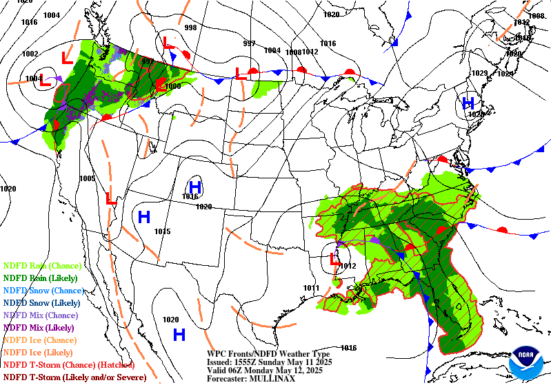
The slow-moving upper low and occluded surface low will continue
to move north, triggering showers and storms across the Mid-
Atlantic on Tuesday. A deep stream of moisture ahead of the system
will push PWAT values above 1.5 inches, and there will be enough
instability (MUCAPE > 1500 J/kg) across portions of North Carolina
and Virginia to support high rain rates in showers and storms. It
seems likely that rain rates could reach or exceed the 1-2 inch per
hour FFGs in Central Virginia (especially in upslope and urban
areas), and possibly the 2.5-3 inch per hour FFGs in southern
Virginia and northeastern North Carolina as well. Models have been
picking up on a faster trend with this system, but there is some
uncertainty in how fast or slow it will move. This will affect the
location of the heaviest rainfall in the warm sector and
along/ahead of the cold front. The general consensus is for the
highest totals to fall over Virginia and northern North Carolina,
but some models are advancing heavy rain even further north.
To account for the faster trend in guidance, the inherited Slight
and Marginal Risk areas from the previous Day 4 ERO have been
shifted north, with the Marginal extending up into portions of
Pennsylvania and New Jersey. The southern edge of the Slight Risk
area has been trimmed up to match QPF trends, and it was extended
east to coastal Virginia where urban areas tend to be more
sensitive to heavy rain and flooding. It's possible that the
location of the Slight Risk will shift in future updates as the
speed of the system becomes more certain.
Dolan
Day 3 threat area:
www.wpc.ncep.noaa.gov/qpf/99epoints.txt
Extended Forecast Discussion
NWS Weather Prediction Center College Park MD
258 AM EDT Sun May 11 2025
The region with heaviest rainfall going into the second half of the
work week will be across the Northern Plains on the back side of
the developing surface low. Although rainfall rates are not
expected to be all that high, multiple hours of moderate rainfall
with rates of half an inch per hour in some cases may just be
enough to cause some minor flooding issues in vulnerable areas, and
therefore the Marginal Risk area has been maintained for Wednesday
(Day 4) from eastern Montana into western North Dakota. Going into
Thursday (Day 5), the heavier rainfall reaches eastern North Dakota
into northern Minnesota where a Marginal Risk area is now planned,
with some of the guidance indicating the potential for 1-2 inch
rainfall totals with some embedded convection.
Elsewhere across the nation, QPF has trended a little lower across
the Mid-Atlantic region for Wednesday as the forcing associated
with the upper low weakens and convection is more scattered and
less organized. After consultation with affected WFOs, the Marginal
Risk has been dropped for the new Day 4 period. The Storm
Prediction Center is also monitoring the potential for some severe
storms on Thursday across portions of the Midwest. Out West, Old
Man Winter will continue to make its presence known across the
Northern Rockies with heavy snow for the highest ranges of
southwestern Montana and northern Wyoming, with the potential for
6-12 inches of accumulation in some cases. Lighter snows are likely
elsewhere across the higher terrain of the Northern Rockies and
Intermountain West.
Very warm weather will continue across the Upper Midwest for the
middle of the week, with highs reaching 85-90 degrees on Wednesday
across the eastern Dakotas and much of Minnesota. The anomalous
warmth then shifts eastward to the Great Lakes and Ohio Valley
regions to close out the week, and much of the East Coast Friday
into Saturday ahead of the cold front. Very hot conditions are
expected across southern Texas for the entire forecast period with
highs exceeding 100 degrees near the Rio Grande, and HeatRisk
reaching the major category for these areas. In contrast, chilly
conditions are likely for the Intermountain West and Northern
Rockies with highs running 5-15 degrees below average with the
upper level trough and increased cloud cover.
Hamrick


