Excessive Rainfall Discussion
NWS Weather Prediction Center College Park MD
843 PM EDT Tue May 6 2025
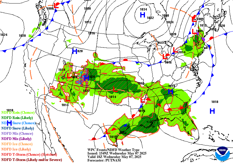
Day 1
Valid 01Z Wed May 07 2025 - 12Z Wed May 07 2025
...THERE IS A MODERATE RISK OF EXCESSIVE RAINFALL OVER PORTIONS OF
EASTERN TEXAS INTO THE LOWER MISSISSIPPI VALLEY...
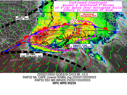
...East Texas into Lower Mississippi Valley...
Steady progression of heavy convection will continue through the
evening with a combination of discrete cells co-located within a
broad MCS propagation along the northern periphery of a sharp
theta_E gradient aligned with a slow-moving warm front. Rainfall
rates this evening will settle between 1-3"/hr with a few cells
over Southern LA and MS potentially breaching 3"/hr, especially
during intra-hour tendencies. Ascent pattern remains very favorable
with a broad cyclonic ULL positioned over the Southern Plains with
extension back into the Western CONUS. HREF EAS prob fields for >3"
is very high (>50%) across all of Central LA extending east into
the mouth of the MS just north of New Orleans. This places some
formidable metro populations within an expected corridor of heavy
rainfall that will likely lead to flash flooding through the
overnight hours. There's already been several flood reports with
associated flash flood warnings lined up along I-20 across the
ArkLaTex, now expanding east through Northern LA. Expect that trend
to continue into MS with the Jackson metro next in line for
anticipated impacts. Despite some lower EAS probs for >3" within
Jackson, there's been a considerable jump in the recent HRRR output
with a solid 2-4" anticipated within the zone of impact from the
propagating MCS. With the cell mergers taking place already across
Southwest LA, there will be a considerable footprint of 2+" totals
with embedded 3-5" amounts that will allow for broad areal coverage
of flash flood warnings the next several hours. The previously
inherited MDT risk from the afternoon remains for many, although
some of the risk was trimmed due to convective impacts already
occurring earlier in the afternoon and evening.
A line of convection remains situated across portions of East TX as
well thanks to parallel boundary layer flow up against a slow
moving cold front that appears to be quickly losing steam as it
moves eastward. Countering LLJ is causing significant degradation
of the frontal progression, something that will allow for training
echoes to be a common occurrence over the course of the evening.
The next few hours will be the most concerning periods before the
setup slowly shifts east into the Lower Sabine allowing for an
addition few inches to potentially fall over the southern portion
of I-45. The Houston metro will be an area of interest this evening
as the slow storm motions could lead to some locally enhanced
totals within the urban corridor. The best threat still looks to
lie northeast of there, but the metro remains solidly in the SLGT
risk for the update.
A MRGL risk now encompasses Deep South TX as hourly hi-res depicts
a stronger mid-level perturbation ejecting out of Coahuila with
scattered thunderstorm development likely overnight, blossoming to
the east as it interacts with the western fringes of the LLJ
component. Areas outside the urban zones will be tough to flood
considering the setup, but there are some indications of locally
heavy totals >2" in spots, so decided to expand further south to
cover for the low-end threat.
...Great Basin...
Slow-moving ULL situated over the Colorado River Basin along with
primary diurnal destabilization has led to scattered heavy
thunderstorms to blossom across portions of Southern NV, Southeast
CA, and now moving into Western AZ. This setup is a mid-tier MRGL
risk with a majority of the rainfall being beneficial for the area,
but sufficient low to mid-level buoyancy coupled with favorable
upper forcing and steep lapse rates could yield a few lingering
storms to exceed 0.50"/hr rates capable of flash flood concerns the
next 2-4 hours. Once we have a sufficient diurnal heat loss after
sunset, the convective setup will dwindle with any activity
petering out to just light showers overnight.
...Central and Southern Plains...
The primary ULL across the Plains will allow for a continued
elevated convective threat with a few heavier cores located under,
and just north of the closed reflection. Regional theta_E's are not
very impressive at the moment, but as noted via regional radar
output, some stronger mid-level vorticity is pivoting around the
general circulation allowing for some heavier convective cores to
initiate over the TX Panhandle and Southwest KS. The main precip
shield will undergo a relatively solid west to east axis of steady
precipitation with a mature axis of deformation on the northwest
flank of the ULL center. This will lead to 1-2" totals, locally
higher to occur over portions of Southwest and South-Central KS
down along the OK state line. The threat for flash flooding is low,
but still within the lower threshold when assessing the cumulative
nature of the precip anticipated. A MRGL risk was maintained for
the above area.
...Northeast...
Remnant ULL situated over the interior Northeast U.S. will pinwheel
northward with shower and storm activity continuing over the next
few hours within the Catskills and western flank of the Hudson
Valley. Elevated convective clusters will linger under the primary
circulation, but will begin to falter as we move into the overnight
period as drier air gets pulled northward around the circulation.
Additional totals of 1" are plausible across places east and
southeast of Lake Ontario which could offer an isolated flash flood
threat for areas that have already seen decent rainfall this
afternoon. The areas that had the greatest impacts earlier will
likely see the threat wane in the next hour as they see the dry air
advection regime take place.
Kleebauer
Day 1 threat area:
www.wpc.ncep.noaa.gov/qpf/94epoints.txt
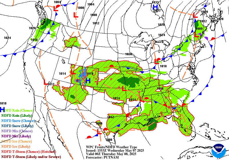
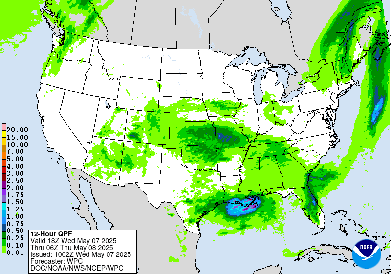
Excessive Rainfall Discussion
NWS Weather Prediction Center College Park MD
418 AM EDT Wed May 7 2025
Day 1
Valid 12Z Wed May 07 2025 - 12Z Thu May 08 2025
...THERE IS A MODERATE RISK OF EXCESSIVE RAINFALL FOR PORTIONS OF
SOUTHERN LOUISIANA...
...Gulf Coast...
The warm front that lifted through the Upper Texas coast has
stalled along the Gulf Coast and be the focus for widespread
showers and thunderstorms through this morning. PWs remain above
the 97.5 climatological percentiles from the Upper TX coast to
southern LA. The flash flood threat remains greatest along the
central Gulf Coast and Lower MS Valley regions where they are most
commonly positioned at the nose of a >500 kg/m/s IVT and PWs that
are approaching 2.0" along the LA coast. RAP soundings in southern
LA Wednesday morning show low-mid level RH values >90% and warm
cloud layers at least 11,000ft deep. These soundings also depict
tall "skinny CAPE" profiles with MLCAPE >500 J/kg. Plus, hodographs
still suggest the potential for organized convection given modest
mid-level shear and low-level helicity (sfc-3km >100 m2/s2). The
SWrly IVT will intersect the stalled frontal boundary in a way that
supports training and back-building convection producing highly
efficient rainfall rates >2"/hr over soils that are increasingly
saturated. This supports the lingering presence of the Moderate
Risk in southern LA through the first half of the day. Note that
most model guidance has the bulk of the Day 1 Excessive Rainfall
threat during the morning hours. There may still be some residual
thunderstorm activity through the afternoon, but most guidance
suggests the bulk of the flash flood threat should wind down some
for the second half of the day.
Further to the west, the Slight Risk remains in place for the
Houston metro given the greater urbanization and susceptibility to
flash flooding. There is the potential for another round of storms
this afternoon that will track over a similar area that was hit by
heavy rainfall yesterday, but any lingering flash flood threat
should begin to wind down after sunset.
...Central Plains & Mid-South...
The lingering mid-upper level low circulation of the Central
Plains will funnel a narrow swath of 700-300mb moisture along the
northern flank of the low, while weak 850mb FGEN and WAA over the
Mid-South. Despite the lack of modest instability, RAP soundings
show >90% saturated sfc-700mb profiles and warm cloud layers up to
9,000ft deep in some cases. With modest upper-level and mesoscale
forcing present, as well as ample low-mid level moisture, efficient
rainfall over saturated soils in parts of the region could result
in additional areas of flash flooding. Aside from minor tweaks to
the area given the latest QPF, the Marginal Risk remains on track.
...Florida Space Coast...
A small Marginal Risk remains in place for urbanized portions of
the I-95 corridor through north Florida along the Space Coast. A
stalled out cold front to the north and typical sea breeze cycles
will trigger rounds of thunderstorms that will have unusually high
PWs available by early May climo in eastern FL. PWs are generally
above 1.75" in northern FL, which is above the 97.5 climatological
percentile according to ECMWF SATs. 00Z RAP soundings for
Wednesday afternoon show highly saturated profiles (>90% within
the sfc-500mb layer), skinny CAPE soundings with >1,000 J/kg of
MLCAPE, and warm cloud layers of at least 12,000ft deep. Most
rainfall will be a welcome sight for the region with severe to
extreme drought having set in. However, the soils are so dry that
rainfall rates >2"/hr would prove too much for the sandy soils of
northern FL to handle, let alone the more urbanized corridor along
I-95. Isolated instances of flash flooding are possible, with the
more urbanized communities most at-risk.
Mullinax
Day 1 threat area:
www.wpc.ncep.noaa.gov/qpf/94epoints.txt
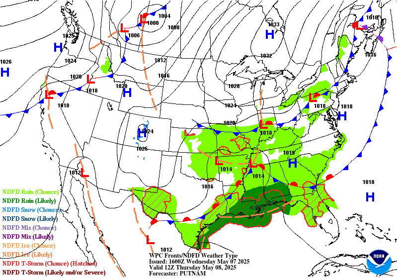
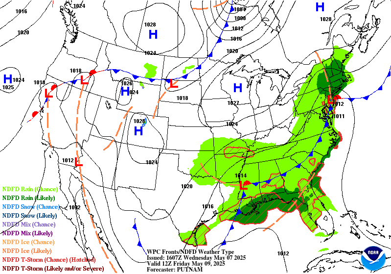
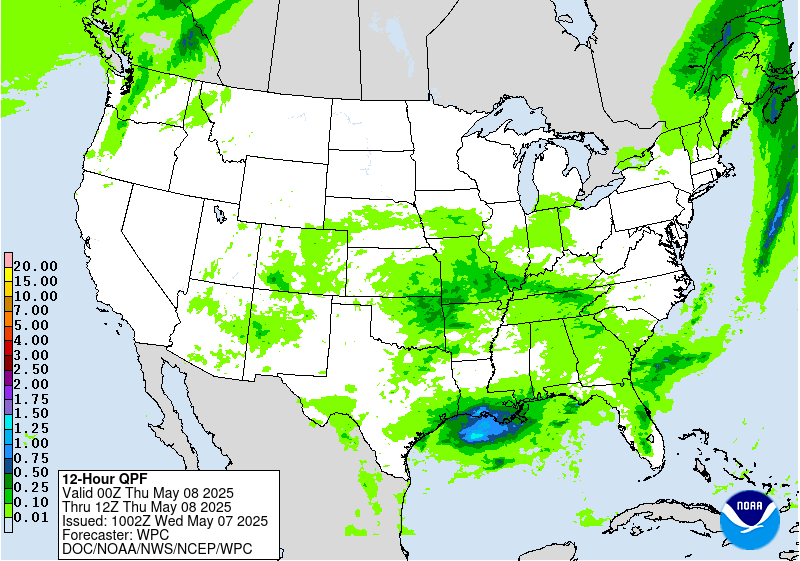
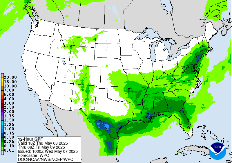
Excessive Rainfall Discussion
NWS Weather Prediction Center College Park MD
418 AM EDT Wed May 7 2025
Day 2
Valid 12Z Thu May 08 2025 - 12Z Fri May 09 2025
...THERE ARE SLIGHT RISKS OF EXCESSIVE RAINFALL OVER PORTIONS OF
THE CENTRAL GULF COAST & THE NORTHEAST...
...Central Gulf Coast & Southeast...
The stalled front draped north of the Gulf Coast will continue to
act as a trigger for additional thunderstorms on Thursday. In
addition to what is still a moist air-mass for early May, there
will be the added assistance of an approaching positively-tilted
500mb trough to provide additional upper-level support. The central
Gulf Coast remains most susceptible to flash flooding given their
closer positioning to a >400 kg/m/s IVT and PWs above 1.75". These
favorable atmospheric parameters are on top of what are now highly
sensitive soils following multiple days worth of heavy rainfall.
The Slight Risk remains in place over a small section of the
Central Gulf Coast, while the expansive Marginal Risk that
stretches from the Ozarks to as far east as the Southeast coast
still looks to be in good shape given the dearth of moisture in
place ahead of the approaching cold front and sufficient
instability (MLCAPE between 500-1,500 J/kg). The FL Space Coast is
also at risk for flash flooding given the similar setup to
Wednesday and potential for more saturated soils following any
thunderstorm activity on Wednesday. Localized flash flooding is
possible, most notably in the region's more urbanized communities
and where PWs are highest.
...Deep South Texas...
A strong cold front pushing south out of central Texas will meet
up with Gulf moisture, resulting in scattered thunderstorms across
the area. These storms will have the benefit of a dual-jet streak
setup aloft which when combined with the approach of a 500mb
shortwave trough will help support thunderstorm clusters into
Thursday night. Low-level easterly winds should lead to
thunderstorm development over the Davis Mountains that could then
propagate SE towards the Rio Grande Valley. With mean wind flow
out of the west, any storms that may form over the Sierra Madre
could also approach the Rio Grande River Thursday evening. As these
initial round of storms generate cold pools, these new cold pools
will invigorate additional clusters of storms Thursday night. Most
areas will see at least some period of heavy rain, which will be
capable of causing isolated instances of flash flooding.
...Northeast...
A complex upper-level evolution will begin on Thursday over the
Northeast that is trending towards a more wet and stormy setup
across the Northeast. An anti-cyclonic wave break over southeast
Canada is splitting a lobe of the positively-tilted upper trough over
southern Ontario into a cut-off low by Thursday night. Guidance
remains split on how far west the blossoming shield of
precipitation will advance, but most guidance is coming into a
consensus on a swath of the Northeast that stems from central PA
and the southern tier of NY on east into areas just west of I-95.
The area of greatest concern lies in northeast PA and into the
Catskills where soils have grown exceptionally sensitive over the
past several days thanks to multiple rounds of heavy rainfall.
As the upper low deepens Thursday night, strong 200-500mb upper
level divergence will work in tandem with strengthening 850-700mb
FGEN and WAA to generate an axis of heavy rainfall. Soundings
between 06-12Z Fri show highly saturated profiles and warm cloud
layers as deep as 9,000ft deep closer to I-95. As of this
discussion, 6-hr FFGs were as low as 1.00" along the northeast
PA/NY state borders. While some recovery is expected, this
highlights that it may not take much more than one inch of rainfall
in 6 hours to cause flash flooding. For these reasons, a Slight
Risk was introduced over parts of the Poconos and Catskills where
there is a decent compromise for higher QPF and where soils are
most sensitive.
Mullinax
Day 2 threat area:
www.wpc.ncep.noaa.gov/qpf/98epoints.txt
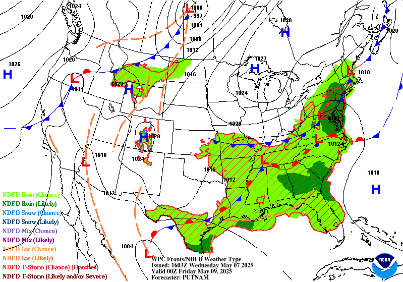
Excessive Rainfall Discussion
NWS Weather Prediction Center College Park MD
418 AM EDT Wed May 7 2025
Day 3
Valid 12Z Fri May 08 2025 - 12Z Sat May 09 2025
...THERE IS A SLIGHT RISK OF EXCESSIVE RAINFALL OVER PORTIONS OF
THE CENTRAL GULF COAST...
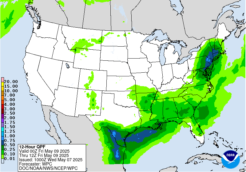
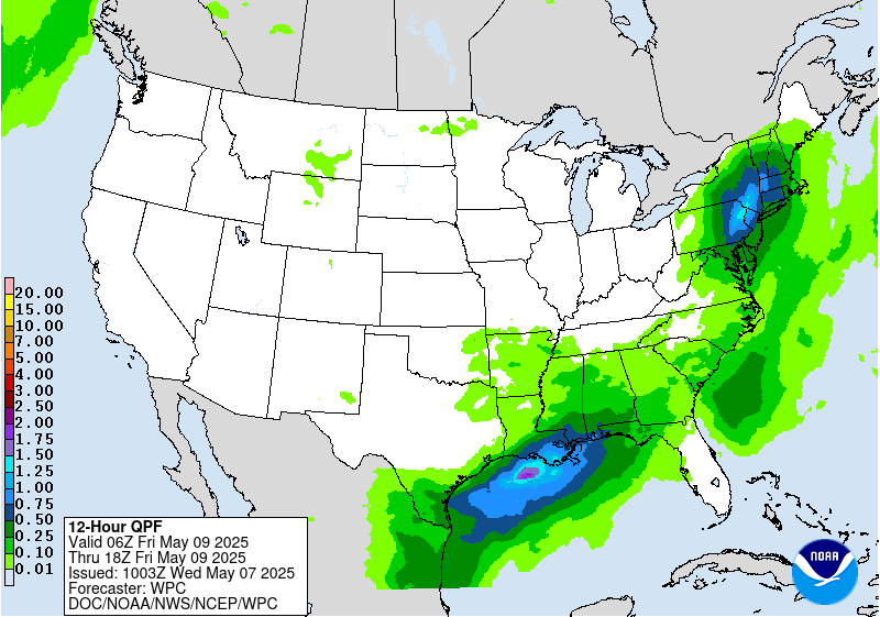
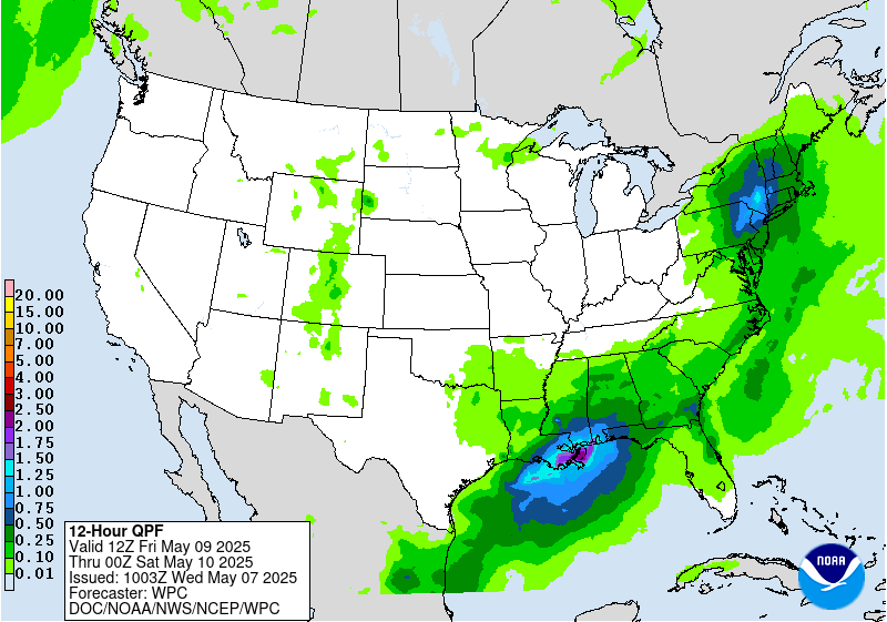
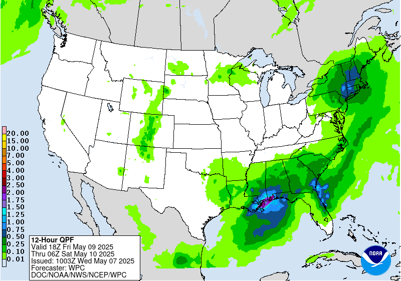
...Gulf Coast & Southeast...
An amplifying and large upper low positioned over the Lower MS
Valley will linger over the region through Friday night with heavy
rainfall likely from the central Gulf Coast to the Southeast coast.
Latest trends in guidance has been to sharpen up a 500mb low over
the Lower MS Valley. The ECMWF SATs page shows an IVT >400 kg/m/s
which is above the 90th climatological percentile. Soundings in the
region also show highly saturated profiles, modest instability,
and deep warm cloud layers. This combined with sufficient vertical
wind shear to help sustain areas of organized thunderstorms is
increasing the threat for Excessive Rainfall over the central Gulf
Coast and FL Panhandle. This setup remains fluid given the recent
trends in guidance to be wetter over the central Gulf Coast, with
the EC- AIFS and GFS GraphCast showing similar trends. Given the
growing soil sensitivities in the central Gulf Coast, the latest
Day 3 ERO update now includes a Slight Risk. The more urbanized
swath of the I-10 corridor is most at-risk for potential flash
flooding on Friday.
...Northeast...
The upper-low evolution stated in the Day 2 discussion holds true
for Friday but unlike Day 2 when the heavy rain threat is confined
to a 6 to at most 12 hour window, the Excessive Rainfall threat
will impact not just the daytime hours on Friday but into Friday
night. Out ahead of the upper low, guidance is showing a
strengthening IVT surpassing 500 kg/m/s off the Northeast coast
that will transport copious amounts of moisture into the Northeast.
Moisture will wrap around the northern flank of the 500mb low into
northern NY and central New England. Farther east, the warm sector
will feature highly saturated and deep warm cloud layers that could
contain some weak elevated instability. There remains some spread
in where the axis of heaviest rainfall sets up, which is why a
Slight Risk was not issued as of this forecast cycle. However,
given trends in guidance are all pointing towards a cut-off low
over the Northeast and soils throughout the region are highly
sensitive, there may be the need for a Slight Risk upgrade in
future forecast updates once confidence increases in where the
heaviest rainfall takes shape.
Mullinax
Day 3 threat area:
www.wpc.ncep.noaa.gov/qpf/99epoints.txt
Extended Forecast Discussion
NWS Weather Prediction Center College Park MD
243 AM EDT Wed May 7 2025
A wavy frontal system and a closed upper low stalling over the
Southeast will continue to support a multi-day heavy
rainfall/runoff threat as fueled by pooling anomalous moisture.
Relatively dry antecedent conditions and higher flash flood
guidance may limit the overall flash flooding potential at least
initially. For now, opted to maintain WPC Excessive Rainfall
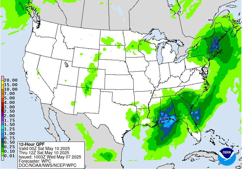
Outlook Marginal risks for Days 4/5 (Saturday and Sunday)
especially considering lingering uncertainty in the details.
However, repeat cells/training along with subsequent cumulative
effects from prior days may lead to threat level upgrades as the
supporting guidance signal continues to increase. Rainfall may
gradually lift northward with time into the Mid-Atlantic by early
next week.
Elsewhere, rainfall will be exiting the Northeast after Saturday
with the upper low. Out West, rain and higher elevations snows will
become more widespread through the weekend and into next week with
amplified upper troughing and surface system approach.
General troughing across the South will keep temperatures near or
below normal at least through the weekend and longer for the
Southeast. Upper ridging out West will support much above normal
temperatures with daytime highs 20-25+ degrees above normal in the
Northern Plains. Above normal temperatures may also extend across
the Upper Midwest/Great Lakes/Northeast by next week. Parts of the
Southwest should approach 100 degrees with at least some localized
heat threat given earlier in the season timing.
Santorelli
Extended Forecast Discussion
NWS Weather Prediction Center College Park MD
243 AM EDT Wed May 7 2025
A wavy frontal system and a closed upper low stalling over the
Southeast will continue to support a multi-day heavy
rainfall/runoff threat as fueled by pooling anomalous moisture.
Relatively dry antecedent conditions and higher flash flood
guidance may limit the overall flash flooding potential at least
initially. For now, opted to maintain WPC Excessive Rainfall
Outlook Marginal risks for Days 4/5 (Saturday and Sunday)
especially considering lingering uncertainty in the details.
However, repeat cells/training along with subsequent cumulative
effects from prior days may lead to threat level upgrades as the
supporting guidance signal continues to increase. Rainfall may
gradually lift northward with time into the Mid-Atlantic by early
next week.
Elsewhere, rainfall will be exiting the Northeast after Saturday
with the upper low. Out West, rain and higher elevations snows will
become more widespread through the weekend and into next week with
amplified upper troughing and surface system approach.
General troughing across the South will keep temperatures near or
below normal at least through the weekend and longer for the
Southeast. Upper ridging out West will support much above normal
temperatures with daytime highs 20-25+ degrees above normal in the
Northern Plains. Above normal temperatures may also extend across
the Upper Midwest/Great Lakes/Northeast by next week. Parts of the
Southwest should approach 100 degrees with at least some localized
heat threat given earlier in the season timing.
Santorelli


