Excessive Rainfall Discussion
NWS Weather Prediction Center College Park MD
1141 AM EDT Fri May 9 2025
Day 1
Valid 16Z Fri May 09 2025 - 12Z Sat May 10 2025
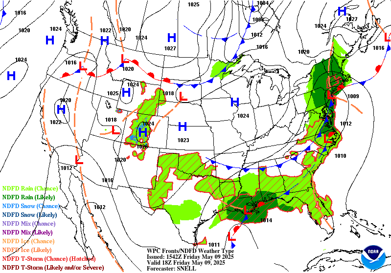
...THERE IS A MARGINAL RISK OF EXCESSIVE RAINFALL OVER PORTIONS OF
THE NORTHEAST & SOUTHEAST...
...Gulf Coast & Southeast...
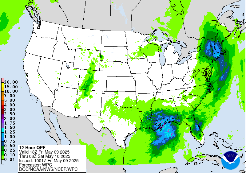
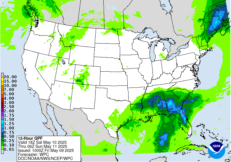
16Z Update: The general consensus from guidance this morning was to
maintain continuity with the broad MRGL in place across the
Southeastern U.S. The corridor of greatest focus will lie between
Baton Rouge/New Orleans over towards Mobile during the evening and
overnight hrs. as a surface low initiates along the Central Gulf
Coast with a strengthening 925-700mb convergence layer on the
east and northeast flank of the cyclone. CAMs this morning were
pretty bullish on a narrow axis of heavier precipitation within
that eastern flank of the low, likely in due part to the convergent
pattern interacting with what is leftover of a quasi-stationary
front situated along the Gulf Coast. Areal PWATs are still within
that +1/+2 deviation marker with the 12z KLIX sounding coming in
~1.75" of atmospheric moisture. Anticipating PWATs to stay below
the usual 2" marker that is customary for higher impact probs with
regards to flash flooding.
The previous discussion touched on the expected amounts pretty well
with a general 1-3" anticipated with some localized prospects of
4-8" within a small zone encompassing Southeast LA over to Southern
MS/AL. The main concerns will be any of the urban zones where
impervious surfaces provide minimal absorption with higher run off
potential. This area will be monitored closely for a targeted
upgrade if conditions warrant, but for now, the lack of heavier
rates (12z HREF probs for >2"/hr running between 10-30% anywhere
during the forecast cycle), as well as neighborhood probs for >5"
signaling 50% or less across the I-10 corridor between New Orleans
to Mobile with the highest probs right along the coast. The
previous MRGL was kept with perhaps a targeted SLGT risk in a small
zone where urbanization factors could enhance the prospects. The
MRGL risk also aligns with the current ML First Guess Fields which
have been pretty consistent the past several iterations.
Kleebauer
..Previous Discussion..
A cutoff upper low is forecast to stall over the Central Gulf
Coast today, accompanied by a nearly stationary frontal boundary
upon which a wave of low pressure will form this afternoon and
evening. Convection moving onshore on the northern and eastern side
of the low will likely result in locally heavy rainfall from
southeastern Louisiana through southern Mississippi and Alabama to
the western Florida Panhandle. Plentiful moisture will be in place
with perceptible water values greater than 1.5 inches, and there
should be just enough CAPE and effective bulk shear along the
immediate coast to support some sustained/organized convection.
Model guidance has come into good agreement on the overall QPF
footprint with some variances on where the highest values are along
the coast. The general consensus among the hi-res CAMs is for the
higher amounts (2-3 inches with locally higher amounts possible) to
fall between far southeastern Louisiana and Destin, Florida. Even
with those amounts, the FFGs in these areas remain fairly high with
3-4+ inches needed to pose flash flooding concerns. The main
concerns with activity this evening will be thunderstorms with
efficient rain rates tracking over any urban or poor drainage
areas. There is a broad Marginal Risk area in place that includes
the Central Gulf Coast and extends into southern Georgia and
portions of North and Central Florida where localized thunderstorms
with heavy rain may pop up this afternoon.
...Northeast...
16Z Update: The main change from the previous forecast was the
removal of areas within the southern bounds of the MRGL risk across
Southeast PA into NJ. With a steady progression of the low to the
northeast, a cold front will drag through the Mid Atlantic with the
final rain threat exiting by later this afternoon. The overall
heavy rain prospects have shifted north towards LI and Southern New
England leaving the threat close to, if not already a nil for flash
flooding the remainder of the period in those southern zones, so
the risk was removed for the above areas.
Further north, rainfall will continue with a narrow corridor for
elevated convection across the eastern half of LI up through the
eastern half of Southern New England where a tongue of higher
850-500mb will be present this afternoon leading to some chances
for elevated thunder with slightly better rates. Outside that, the
primary precip scheme will be stratiform leading to capped rates
and potential for flash flooding residing in the lower end of the
inherited MRGL risk threshold. The main reason for the MRGL
extension to the west is the very moist antecedent soils where NASA
SPoRT is consistently depicting the top soil layer running >90%
saturation meaning small stream and river flooding will exacerbate
runoff concerns through the period. Totals between 1-2" will be the
most common across the Hudson Valley to points east with rates
sufficiently capped <1"/hr with low probs of even reaching 2"/3-hrs
(20-30%) anywhere with the best threat over LI. The MRGL was
maintained for the low-end threat across New England, Northeast PA,
and Eastern NY State.
Kleebauer
..Previous Discussion..
A slow-moving coastal low will bring a prolonged period of onshore
flow to portions of the Northeast, which will produce some decent
rainfall totals across the region. Most of the precipitation on the
northern side of the system will be in the form of stratiform rain
with modest rain rates at best, but rainfall totals will add up
today into tonight, resulting in widespread amounts of 1-2 inches,
locally higher, in the 24 hour period. Rain rates will likely fall
short of the 1/3/6 hr FFGs in most locations. However, soils
across the region are already saturated and there will likely be
enough runoff to flood rivers, creeks, streams, and even some low-
lying areas. The better chances of localized flash flooding will be
to the south over Long Island and southern Connecticut. Hi-res
CAMs have been consistently showing a higher stripe of QPF across
Long Island where convection will move onshore ahead of the surface
low. Given ample moisture from the Atlantic and a modest amount of
CAPE, showers and storms that develop will likely be able to
produce rain rates greater than 1 inch per hour. A Marginal Risk
area is in place across portions of the Northeast to account for
the localized flash flood threat across the region.
Dolan
Day 1 threat area:
www.wpc.ncep.noaa.gov/qpf/94epoints.txt
Excessive Rainfall Discussion
NWS Weather Prediction Center College Park MD
1141 AM EDT Fri May 9 2025
Day 2
Valid 12Z Sat May 10 2025 - 12Z Sun May 11 2025
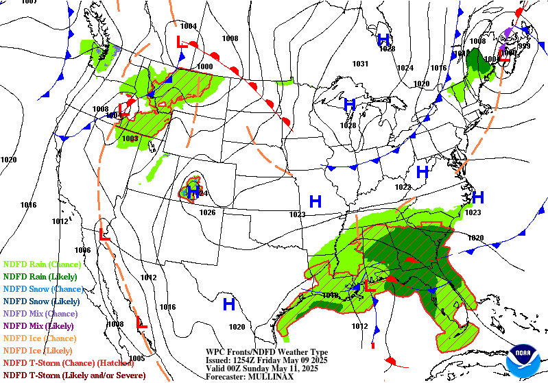
...THERE IS A MARGINAL RISK OF EXCESSIVE RAINFALL OVER PORTIONS OF
THE SOUTHEAST & NEW ENGLAND...
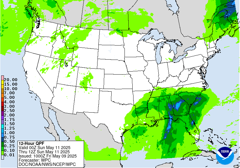
...Southeast...
A stationary boundary will remain draped across the Southeast,
with several waves of low pressure expected to form along the
boundary over the weekend as upper level short waves pivot around
the upper low over the region. Compared to Friday, the QPF
footprint will translate east into areas with relatively drier
antecedent conditions. Models are agreeable that widespread
rainfall totals of 1-2 inches are expected across southern and
central Alabama and Georgia and North Florida. Locally higher
amounts above 2 inches will also be possible, but exactly where may
vary within the region. The highest QPF will likely be along the
immediate coast in the Florida panhandle as convection moves
onshore, and training onshore convection will likely pose the
highest threat for flash flooding. Efficient rain rates (2+ inches
per hour) are expected due to a saturated atmosphere with ample
CAPE and shear to support thunderstorms. Flash flooding may be
fairly limited to urban and poor drainage areas given the higher
FFGs (3-5 inches). To account for this, a Marginal Risk area is in
place across much of the Southeast.
...New England...
As a coastal low tracks south of the coast, moderate precipitation
will focus over New England on the northern side of the system.
The low is expected to be fairly progressive, which might help to
limit rainfall totals, but a decent swatch of rainfall is forecast
from Vermont and New Hampshire through southern Maine. Soils in
Vermont and New Hampshire are expected to be somewhat sensitive
given heavy rains expected today. Rainfall will be mostly
stratiform across New England, limiting rain rates, but there will
likely be enough moisture and instability to produce localized
rates of 1+ inches over the course of a few hours, which may come
close to 3/6 hr FFGs. A Marginal Risk area remains in place across
Vermont, New Hampshire, and most of Maine, but northwestern Maine
was removed from the Marginal as model QPF has trended downwards.
Dolan
Day 2 threat area:
www.wpc.ncep.noaa.gov/qpf/98epoints.txt
Excessive Rainfall Discussion
NWS Weather Prediction Center College Park MD
1141 AM EDT Fri May 9 2025
Day 3
Valid 12Z Sun May 11 2025 - 12Z Mon May 12 2025
...THERE IS A SLIGHT RISK OF EXCESSIVE RAINFALL OVER PORTIONS
OF THE SOUTHEAST...
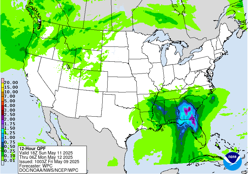
A wave of upper level energy will pivot around the upper low across
the Southeast, sparking another wave of convection from the Gulf
Coast to the Southeast Atlantic Coast. Models are showing a more
organized area of surface low pressure moving into the Southeast
with significant rainfall totals on the eastern side. Widespread
totals of 1.5-2.5 inches are expected with locally high amounts
above 3 inches. Considering this will be the second day in a row
with heavy rainfall in the Southeast, areas with saturated soils
from the day before may be slightly more prone to flood impacts
with additional heavy rain on Sunday. The most favorable flash
flood conditions will be across North Florida and southern and
central Georgia where 1000+ J/kg MUCAPE and 30+ knots of effective
bulk shear with support organized convection. Additionally,
precipitable water values in excess of 1.5 inches will support
efficient rain rates in strong thunderstorms. A Marginal Risk area
is in effect for much of Alabama, Georgia, South Carolina, and
North and Central Florida, with an embedded Slight Risk area over
North Florida and southern and central Georgia.
Dolan
Day 3 threat area:
www.wpc.ncep.noaa.gov/qpf/99epoints.txt


