Excessive Rainfall Discussion
NWS Weather Prediction Center College Park MD
1132 AM EDT Mon May 12 2025
Day 1
Valid 16Z Mon May 12 2025 - 12Z Tue May 13 2025
...THERE IS A MODERATE RISK OF EXCESSIVE RAINFALL OVER SOUTHEAST
FLORIDA...
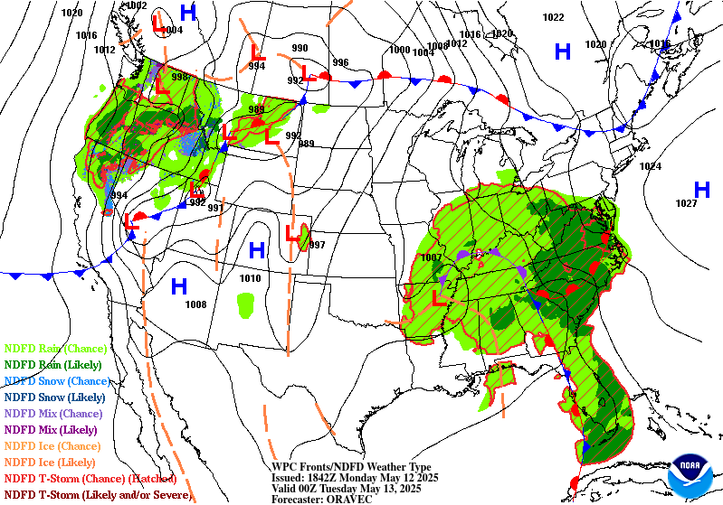
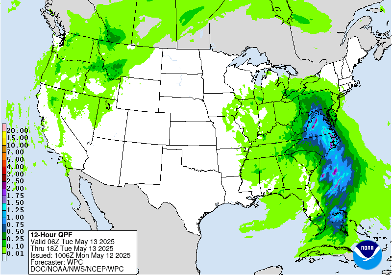
16Z Update:
The inherited Day 1 outlook remains in good shape with only
minimal adjustments made to the 16Z update based on current
observations and radar trends. For the Moderate Risk area for the
Greater Miami area, no significant adjustments were made. Morning
heavy rain has exited the coast, with a brief lull expected
through the afternoon. A conditional threat of another round or two
of heavy rainfall exists through tonight ahead of an approaching
front with potentially an additional 2-4" (locally higher). This
rainfall on top of the locally 1-4" that fell over the past 24
hours could bring renewed urban flooding issues. The HREF and REFS
probabilities suggest some isolated/localized 2" hourly totals.
A higher-end Slight exists across much of North Carolina with
potential of widespread 1-3" of rain through tonight. Locally
higher amounts will be possible across the upslope region of
western NC as well as portions of central to eastern NC. Isolated
rain rates above 2"/hr will be possible, particularly in the
eastern areas. This could cause isolated to scattered flooding
issues, particularly for urban areas and in areas of terrain.
Taylor
---previous discussion---
A deep upper low will be slowly moving north towards the Tennessee
Valley, dragging a surface low pressure system north with it. The
trailing cold front will gradually push towards the Atlantic Coast
while the warm front lifts north into the southern mid-Atlantic.
This system will direct a stream of deep anomalous moisture into
the Southeast and Mid-Atlantic that will support widespread showers
and storms with heavy rain potential across these regions. PWATs
are expected to surge to over 1.5 inches from Virginia to Georgia
and over 2 inches over the Florida Peninsula, which will certainly
provide the needed moisture for elevated rain rates in stronger
convection.
A Moderate Risk area has been introduced for the urban corridor of
Southeast Florida where heavy rain may result in significant
flooding impacts. The synoptic setup is favorable for a heavy rain
event over South Florida with deep moisture and southerly winds
shifting to southwesterly ahead of an approaching cold front. Waves
of showers and storms are expected throughout the period, and
there will be plenty of moisture and instability to support high
rain rates in excess of 2 inches per hour. CAMs are showing the
potential for 3-4, locally up to seven, inches of rain possible
today. Yesterday's 18Z HREF was showing 60-70% probability of 24
hour QPF exceeding 8 inches, but the 00Z HREF dropped probabilities
of 8 inches in 24 hours down to 40-50%, indicating some
uncertainty in how high the max QPF amounts may be. Regardless of
the exact amount, flooding impacts are likely for the urban
corridor of Southeast Florida.
To the north, strong south-southeasterly mean flow will focus QPF
maxes along the Carolina Coast and along upslope regions of the
southern Appalachians. CAMs have consistently shown 2-4 inches of
precipitation, with locally higher amounts possible, over the 24
hour period in these areas. There was discussion about potentially
upgrading to a Moderate Risk for sensitive areas in the
Appalachians, but it was decided to remain at a high-end Slight
Risk given a lack of instability and limited rain rates. Rain rates
could periodically exceed 1 inch per hour, which would support
isolated to scattered flash flooding concerns for the western
Carolinas and Southwestern Virginia, but most likely would not
support a risk higher than Slight. The higher rain rates (1-2
inches per hour) are expected to be in convection near the coasts
where instability will be higher.
To cover these flooding threats, a Slight Risk area extends from
Virginia to the Florida peninsula. There will also be localized
heavy rain potential across the Tennessee and Mid-Mississippi
Valleys, Mississippi, and Alabama. There will be decent instability
in the vicinity of the surface low to produce convection with 1
inch per hour rain rates. Given that soils in these regions are
saturated from recent heavy rains, isolated flooding concerns will
be possible, and therefore a Marginal Risk of excessive rainfall is
in place.
Dolan
Day 1 threat area:
www.wpc.ncep.noaa.gov/qpf/94epoints.txt
Excessive Rainfall Discussion
NWS Weather Prediction Center College Park MD
1132 AM EDT Mon May 12 2025
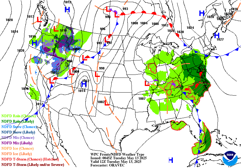
Day 2
Valid 12Z Tue May 13 2025 - 12Z Wed May 14 2025
...THERE IS A SLIGHT RISK OF EXCESSIVE RAINFALL OVER PORTIONS OF
THE MID-ATLANTIC...
The slow-moving upper low and occluded surface low will continue
to move north, and showers and storms will focus across the Mid-
Atlantic on Tuesday. Deep moisture ahead of the system will push
PWAT values above 1.5 inches, and there will be enough instability
(MUCAPE > 1500 J/kg) across portions of North Carolina and Virginia
to support high rain rates (1-2 inch per hour), which may rival 1
and 3 hr FFGs. Upslope flow along the Appalachians from southern
Pennsylvania through Virginia will also help to enhance rainfall,
with generally 1.5-2.5 inches of rain expected across this area
with locally higher amounts possible. After heavy rain on Monday,
these areas may be more sensitive to flooding given higher soil
moisture, and isolated to scattered flash flooding concerns are
expected. This will warrant a continuation of the Slight Risk area
from northeastern North Carolina through Virginia and portions of
West Virginia, Maryland, and southern Pennsylvania.
Isolated flash flooding may also be possible for portions of the
Ohio Valley and Appalachians. Moisture wrapping around the northern
side of the low pressure system combined with sufficient
instability near the surface low will support scattered convection
with relatively slow storm motion. Therefore, a Marginal Risk is in
place for these regions.
Dolan
Day 2 threat area:
www.wpc.ncep.noaa.gov/qpf/98epoints.txt
Excessive Rainfall Discussion
NWS Weather Prediction Center College Park MD
1132 AM EDT Mon May 12 2025
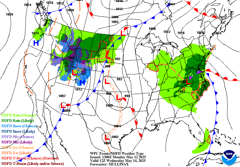
Day 3
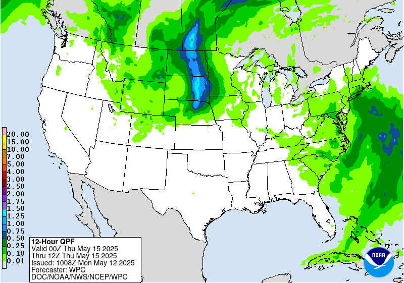
Valid 12Z Wed May 14 2025 - 12Z Thu May 15 2025
...THERE IS A MARGINAL RISK OF EXCESSIVE RAINFALL OVER PORTIONS OF
THE NORTHERN PLAINS AND MID-ATLANTIC...
...Northern Plains...
A deep upper level trough will push across the Northwest to the
Plains on Wednesday, resulting in a strengthening low pressure
system in the northern Plains. Stratiform rain with likely some
embedded convection on the northern and western side of the low are
forecast to produce 0.5-1 inches of rain, with locally higher
amounts possible, in eastern Montana and northeastern Wyoming. The
main threat will be due to the persistent nature of the
precipitation in this area, starting up Tuesday night and
continuing through Wednesday into Wednesday night. Rainfall totals
will likely come close to the 6 hour FFGs in eastern Montana.
For the Dakotas, convective precipitation is forecast to develop
ahead of the low along a strengthening frontal boundary. Models are
in good agreement on the axis of heaviest precipitation setting up
over central North Dakota and eastern South Dakota. PWAT values
are expected to be at least 2 standard deviations above normal
(1-1.5 inches), and there should be enough instability (MUCAPE >
1500 J/kg) during the day on Wednesday to support at least an
isolated flash flood threat.
...Mid-Atlantic...
Soils are expected to be thoroughly saturated across the Mid-
Atlantic after heavy rain on Monday and Tuesday, which may create a
low end flood threat with lingering showers on Wednesday. The
slow-moving surface low is forecast to track right over the Mid-
Atlantic with scattered precipitation, and there should be enough
instability near the low to support some convection capable of
producing locally heavy rain. Therefore, a Marginal Risk area was
introduced for portions of the Mid-Atlantic.
Dolan
Day 3 threat area:
www.wpc.ncep.noaa.gov/qpf/99epoints.txt
Extended Forecast Discussion
NWS Weather Prediction Center College Park MD
258 AM EDT Mon May 12 2025
The region with heaviest rainfall going into the second half of the
work week will be across North Dakota and into Minnesota. Although
rainfall rates are not expected to be all that high, multiple
hours of moderate rainfall with rates of half an inch per hour in
some cases may just be enough to cause some minor flooding issues
in vulnerable areas, and therefore the Marginal Risk area has been
maintained for Thursday (Day 4) from eastern North Dakota into
central/northern Minnesota. Going into Friday (Day 5), showers and
thunderstorms increase in coverage and intensity across the Mid-
South in the general vicinity of a quasi-stationary front that will
be intercepting advection of deep moisture from the south. A
Marginal Risk area is now valid from Arkansas to eastern Kentucky
where the model QPF is strongest for organized convection.
Elsewhere across the nation, the Storm Prediction Center is
monitoring the potential for some severe storms on Thursday across
portions of the Midwest. Out West, it will seem more like March
across
the northern Rockies with heavy snow for the highest ranges of
southwestern Montana and northern Wyoming, with the potential for
6-12 inches of accumulation in some cases through mid-week, and a
second round of snow for the central and northern Rockies Sunday
into Monday as the next upper trough and shortwave moves into the
region. Lighter snows are likely elsewhere across the higher
terrain of the northern Rockies and Intermountain West.
Very warm weather will be commonplace across the eastern half of
the country to close out the work week, with highs well into the
80s and even lower 90s from the Ohio Valley and Mid-Atlantic
southward to the Gulf Coast. Very hot conditions are expected
across southern Texas for the entire forecast period with highs
exceeding 100 degrees near the Rio Grande, and HeatRisk reaching
the major to extreme category for some of these areas. In
contrast, chilly conditions are likely for the Intermountain West
and Northern Rockies with highs running 5-15 degrees below average
with the upper level trough and increased cloud cover.
Hamrick


