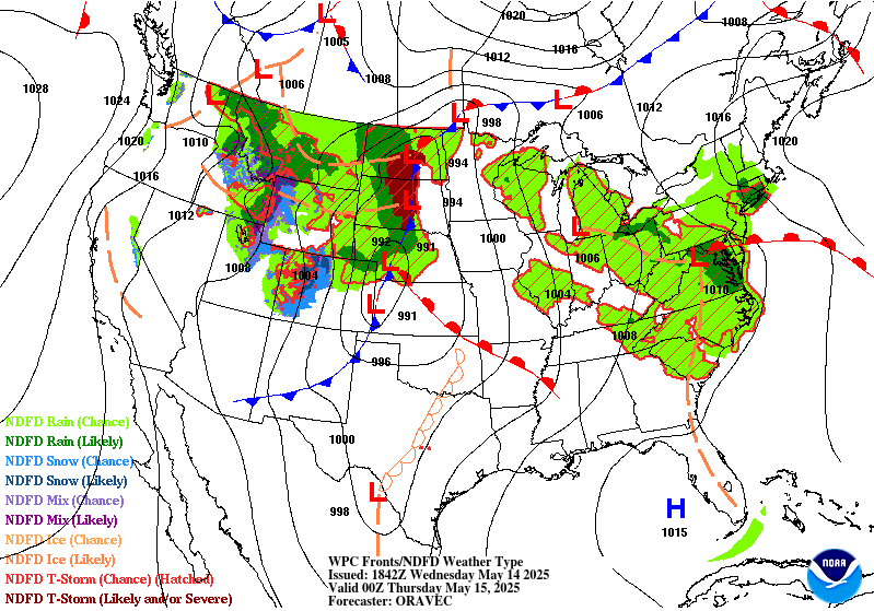
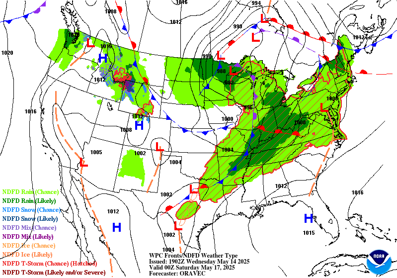
Excessive Rainfall Discussion
NWS Weather Prediction Center College Park MD
252 PM EDT Wed May 14 2025
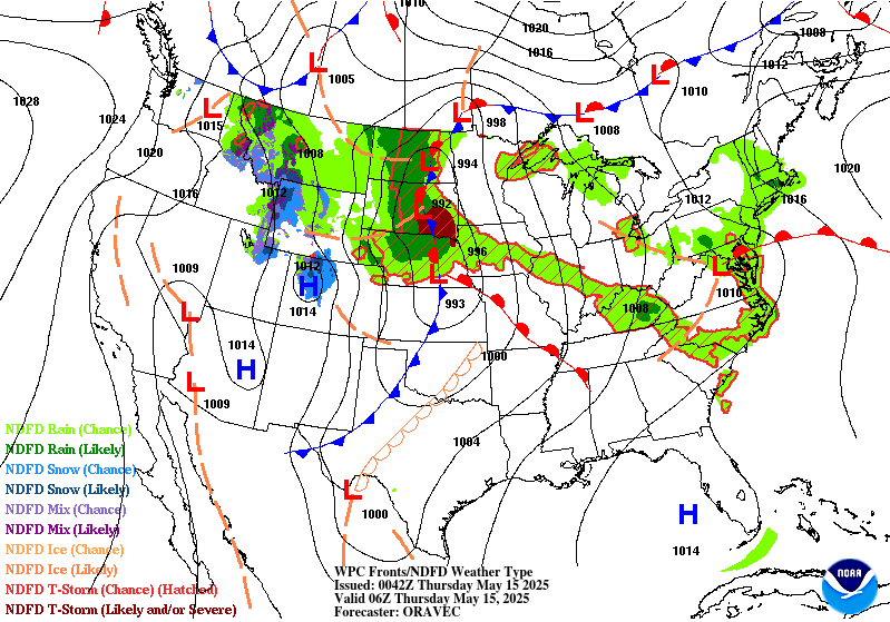
Day 1
Valid 16Z Wed May 14 2025 - 12Z Thu May 15 2025
...THERE IS A SLIGHT RISK OF EXCESSIVE RAINFALL FOR PORTIONS OF
THE MID-ATLANTIC INTO THE CENTRAL APPALACHIANS...
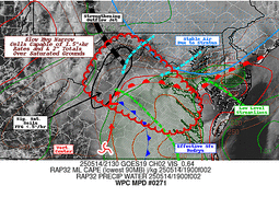
...Mid-Atlantic...
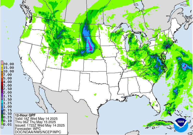
16Z Update: Portions of the Mid Atlantic extending from the
Tidewater of VA to the northwest across the Central and Northern
Blue Ridge to the Appalachians Front are now in a SLGT risk after
coordination with surrounding WFO's. The overall synoptic pattern
remains unchanged with a slow progression of a negatively tilted
500mb trough currently centered over the eastern Ohio Valley when
assessing WV satellite and recent UA analysis. Compared to
yesterday, widespread elevated totals are not likely to be seen
with the anticipated setup as the primary precip schema will lean
to more scattered variety thunderstorms with potential for
localized heavy maxima given the 90th percentile PWATs situated
over the area (12z KIAD sounding of 1.31"). Convection is slowly
beginning to initiate downstream of the mean trough across Southern
VA into NC with a greater coverage anticipated between 18-00z
during peak diurnal heating. MUCAPE between 500-1500 J/kg will be
co-located within the terrain extending through the Blue Ridge and
adjacent Appalachians with 1000-2000 J/kg bisecting the VA
Tidewater up into Northern VA. This instability presence will be
plenty to help maintain some stronger convective cores capable of
localized rainfall rates between 1-2"/hr at peak intensity. Coupled
with very low 1/3/6 hr FFG intervals after yesterdays heavy rain
episode, this is sufficient for short term rates to exacerbate
already compromised soils as NASA SPoRT maintains a signature of
>90% soil moisture presence across pretty much the entire Central
Mid Atlantic.
12z HREF neighborhood probs for >2" of precip indicates a broad
footprint of 50 to 90% over the aforementioned area of focus with
modest probs (20-40%) for >3" in the same zone. The most concerning
depiction is within the 3 and 6-hr exceedance probability output
showing a large chunk of the Blue Ridge, Central Appalachians, and
Southern Laurels around 40-80% and 50-80% respectively. This is
typically a good indicator for a locally more significant event
potential in most areas of the CONUS, but especially over terrain
with lower FFG indices starting out. This allowed for an upgrade to
a SLGT risk in those locations extending from the VA Tidewater,
northwest through parts of Northern VA, Blue Ridge and neighboring
Shenandoah, into the Central Appalachians. A broad MRGL
encompasses the metro corridor over MD along with Western and
Central PA down towards NC as coverage and impacts are anticipated
to be more isolated in these zones with greatest threat likely
within urban areas due to higher runoff risk.
Kleebauer
...Northern Plains...
16Z Update: After last nights shift of the QPF maxima further west,
the guidance has come into agreement with little run to run
variability when assessing the two main CAMs periods. The
antecedent dry soils will be the "scale tipper" to the MRGL side of
the threat as convective premise will likely be more of a welcomed
sight, initially with some localized flood prospects in the Western
High Plains most likely incurring due to hydrophobic soils if
rainfall rates breach 2"/hr, or similar rates impacting a town with
more runoff potential given urbanization factors. The nocturnal MCS
development off the Front Range into SD/NE will be worth
monitoring, but if the convection leans closer to the Sandhill
domain along those borders into NE, the threat for flash flooding
will likely be muted outside of direct impacts on any towns in the
path of the complex. The MRGL risk was relatively unchanged given
the above factors, but pending the output from the first round of
convection along the lingering surface trough in conjunction with
the secondary convective onslaught anticipated this evening, a
targeted upgrade could be plausible. This is something we will
monitor as the day progresses.
Kleebauer
..Previous Discussion..
A deep upper level trough centered over the Intermountain West this
morning will become negatively tilted as an impressive shortwave
draws plentiful upper level energy into the northern Plains.
Surface cyclogenesis is expected ahead of this trough over Kansas,
which will track NNE into south-central North Dakota by Thursday
morning. A line of convection associated with the leading/eastern
edge of the trough is moving into far western South Dakota from
Wyoming, and this line of storms will track NNE over the western
Dakotas through the morning. The primary flooding threat will be
from a new line of storms which will develop over western South
Dakota with peak heating this afternoon, then track very slowly
eastward, as embedded cells move north, parallel to the line. This
will result in some training of convection, leading to an isolated
flash flooding threat.
In coordination with UNR/Rapid City, SD; FSD/Sioux Falls, SD; and
ABR/Aberdeen, SD forecast offices, the inherited Slight Risk was
removed with this update, and the surrounding Marginal shifted well
to the west of inherited. The westward shift was due largely to a
shift in the guidance slowing the forward motion of the trough.
While this increased forecast rainfall amounts some, the area of
the Dakotas now highlighted is in Moderate to in some localized
cases Severe drought. NASA SPoRT soil moisture imagery shows the
area has next to no moisture. Thus, despite the potential for heavy
rainfall at times in some areas, the flooding threat was
determined to be isolated.
Wegman
...Ohio Valley...
Scattered convective activity within an elevated moisture advection
regime will occur this afternoon and evening with the greatest
coverage anticipated in the evening thanks to added forcing from a
mid-level perturbation moving up from the southwest. Sufficient low
to mid-level buoyancy coupled with elevated PWATs will help with
locally heavy rainfall potential across areas extending from
Southern IN down into KY with totals potentially reaching between
1-3" in the strongest convective impacts. 12z neighborhood probs
for >2" are modest (20-40%) across the above area with some
elevated probs for >1" (50-70%) in the same locale. Considering the
nature of the soil anomalies >80% within areas of Eastern KY into
the Ohio River basin in conjunction with the heavier rainfall
rates, a MRGL risk was expanded westward to encompass the threat.
Kleebauer
...Michigan...
Near record daily PWATs (12z KAPX sounding of 1.37") and
anticipated lake breeze initiation thanks to strong differential
heat flux off Lake Michigan will generate a period of slow-moving
strong convective cores capable of rainfall rates of 1-2"/hr during
anticipated impact. Modest 10-year ARI exceedance probs based on
the latest hi-res ensemble suite (15-30%) across Northwest MI
signal a modest threat for localized flash flood concerns over any
urban zones within stronger convective cores. The key is the slower
mean storm motions anticipated with much of the convective
development likely anchored to the lake breeze and subsequent
outflow generation. Ensemble mean areal average QPF around 0.5-1"
with deterministic maxima between 2-3" was enough to warrant a
targeted MRGL risk issuance within a zone situated west of I-75 and
just north of I-96 in Lower MI. This is the primary area of concern
with the greatest threat up closer to Traverse City and points just
south.
Kleebauer
Day 1 threat area:
www.wpc.ncep.noaa.gov/qpf/94epoints.txt
Excessive Rainfall Discussion
NWS Weather Prediction Center College Park MD
252 PM EDT Wed May 14 2025
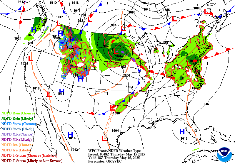
Day 2
Valid 12Z Thu May 15 2025 - 12Z Fri May 16 2025
...THERE IS A MARGINAL RISK OF EXCESSIVE RAINFALL FOR PORTIONS OF
THE NORTHERN PLAINS...
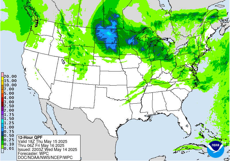
...Northern Plains...
20Z Update: Very little change necessary from the previous forecast
as the expected synoptic and mesoscale evolution along with
reputable precip forecast remains pretty consistent. Locally
heavier cores will be embedded within the well-defined TROWAL
located across ND through the period leading to some localized
flash flood prospects within more urbanized zones. Considering the
lack of a stronger convective output and rates likely more confined
between 0.5-1"/hr at peak intensity within the higher QPF
footprint, the threat for flash flooding will remain within the
MRGL category.
Kleebauer
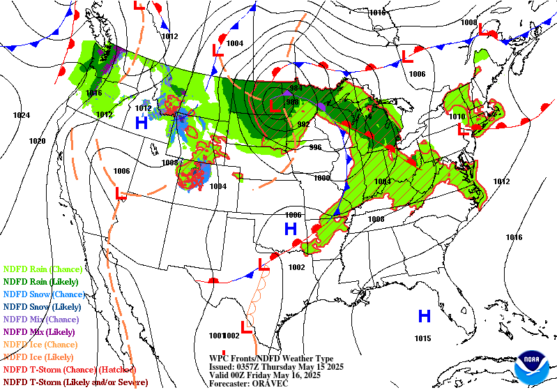
..Previous Discussion..
The low over the northern Plains will become vertically stacked as
the upper trough catches up with the surface low. With the new
vertically stacked low moving only very slowly towards the
northeast, this will make for a prolonged period of rain on the
cold/northwest side of the center, as it becomes the comma head
region of the low. This area of the low is expected to be largely
devoid of convection given the lack of instability making it quite
that far north and west. Thus, expect the 2-3 inches of additional
rainfall from today to have only a minimal impact given the still
largely dry soils over much of North Dakota. This Marginal was
shifted well to the west following the latest guidance trends, so
the Marginal was removed from much of Minnesota due to lack of
expected rainfall.
Wegman
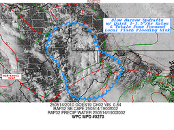
...Western Pennsylvania to Central Appalachians...
Progression of a broad warm front will lead to convective
development across the Ohio Valley, spreading northeast into
Western PA and the adjacent highlands of MD/WV to the south. The
progressive nature of the threat will curb the maximum potential,
but the low FFG's situated across the higher terrain of the Mid
Atlantic allows for a greater likelihood with any convective impact
over the course of the forecast. Some of the CAMs are pretty
bullish on the overall QPF footprint within the outlined zone with
some localized 1-2+" totals sprinkled throughout the terrain up
towards Northwest PA. Neighborhood probs of 60-80% for >1" and
25-40% for >2" are situated within that area from Erie, PA down to
Tucker County WV. These probs are sufficient for some flash flood
risk given the accompanying antecedent conditions. A MRGL risk was
added to the above region to account for the setup.
Kleebauer
Day 2 threat area:
www.wpc.ncep.noaa.gov/qpf/98epoints.txt
Excessive Rainfall Discussion
NWS Weather Prediction Center College Park MD
252 PM EDT Wed May 14 2025
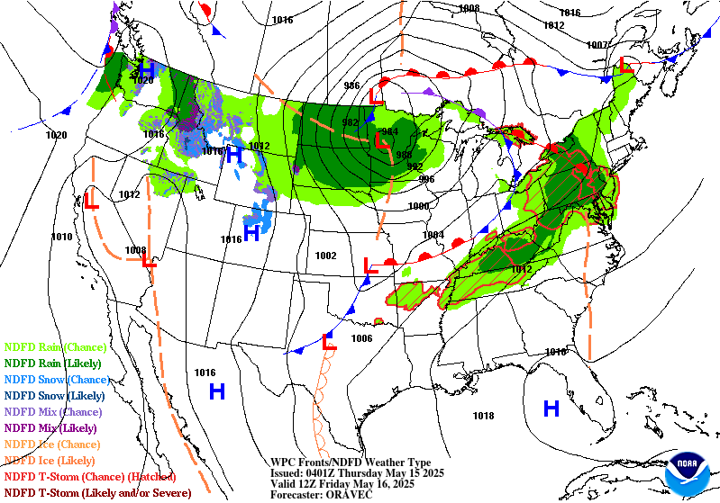
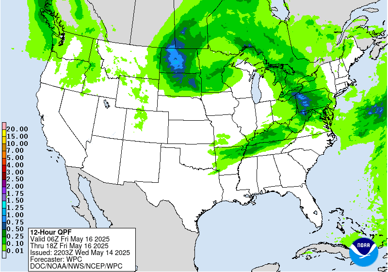
Day 3
Valid 12Z Fri May 16 2025 - 12Z Sat May 17 2025
...THERE IS A SLIGHT RISK OF EXCESSIVE RAINFALL FOR PORTIONS OF
THE OHIO AND TENNESSEE VALLEYS...
A potent shortwave trough will round the periphery of the
vertically stacked low over the northern Plains and upper Great
Lakes on Friday. This shortwave will tap into a low level jet of
Gulf moisture riding the prior low's occluded front. This will
reinvigorate the front, resulting in rather fast northeastward
moving storms across the risk area. Much of this area remains
saturated given elevated soil moisture anomalies on the latest NASA
SPoRT due to prior storms, so any training thunderstorms will be
capable of producing flash flooding. The trend over the past 12 hrs
is for a greater training threat within the confines of the west
to east oriented front aligned from the Mid-Mississippi Valley
through the Central Ohio Valley with a proxy close to the Ohio
River down into KY. With such a well-defined theta_E gradient and
mean flow becoming more parallel to the boundary orientation, the
threat for waves of convection to funnel over a general area has
risen with ensemble bias corrected output and ML QPF placement
actually a bit further south overall. There is some merit to the
front being located a bit further into KY as we move closer to the
event, a trend that has occurred quite often inside 48 hrs with the
best convection co-located near the better instability access. A
SLGT risk is now embedded within the broad MRGL from previous
forecast with the higher risk now running from the Mid-Mississippi
River basin, east through the Central Ohio Valley to far western
WV.
Wegman/Kleebauer
Day 3 threat area:
www.wpc.ncep.noaa.gov/qpf/99epoints.txt


