Excessive Rainfall Discussion
NWS Weather Prediction Center College Park MD
859 PM EDT Fri May 9 2025
Day 1
Valid 01Z Sat May 10 2025 - 12Z Sat May 10 2025
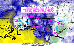
...THERE IS A MARGINAL RISK OF EXCESSIVE RAINFALL OVER PORTIONS OF
THE CENTRAL GULF COAST...
Convection along the central Gulf Coast will continue to pose an
isolated flash flood risk tonight. One more round of intense
convection is expected to move into coastal areas tonight into
early Saturday, although some model differences remain with the
specifics. The 12z REFS is the furthest west, bringing a max into
southern MS, with the 23z HRRR the furthest east, more into the
western FL Panhandle. At this point leaning a bit more towards the
recent HRRR runs, but in reality anywhere from southern MS to the
western FL Panhandle is in play for additional heavy convection and
3"+ more of rain in spots. Not seeing quite enough model
consistency to go with a Slight risk, but with earlier rainfall
increasing saturation...it does seem probable that at least a few
more instances of flash flooding will occur into the overnight
hours wherever this stronger convection moves onshore.
Chenard
Day 1 threat area:
www.wpc.ncep.noaa.gov/qpf/94epoints.txt
Excessive Rainfall Discussion
NWS Weather Prediction Center College Park MD
353 AM EDT Sat May 10 2025
Day 1
Valid 12Z Sat May 10 2025 - 12Z Sun May 11 2025
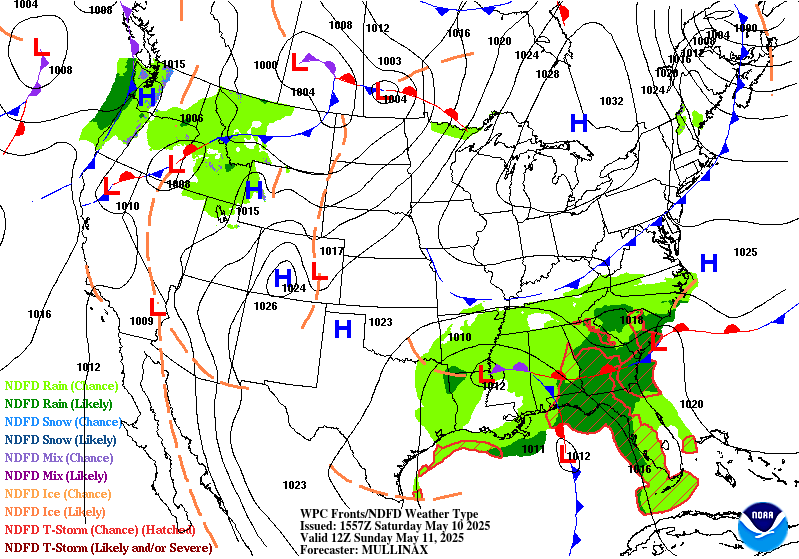
...THERE IS A SLIGHT RISK OF EXCESSIVE RAINFALL OVER PORTIONS OF
THE FLORIDA PANHANDLE AND SOUTHEASTERN ALABAMA...
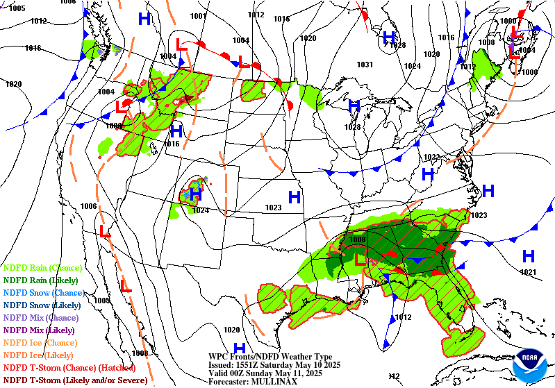
...Southeast...
A stationary upper low will remain parked over the Central Gulf
Coast through the weekend. A potent shortwave trough will pivot
around the upper low today, sparking convection across the
Southeast. At the surface, a low pressure system slowly tracking
north into the Central Gulf Coast states will become occluded, with
nearly stationary frontal boundaries extending south into the Gulf
and east to the Atlantic Coast. Thunderstorms are expected to form
in the warm sector of the system today, with some overrunning
precipitation on the northern side of the system as well. Heavy
rain should initially focus on the Florida Panhandle this morning,
then spread further into the Southeast and Florida peninsula
throughout the day.
Showers and storms tracking north along the frontal boundary that
extends into the Gulf will result in areas of repeat convection in
the Florida Panhandle and southeastern Alabama that will likely
cause high rainfall totals over the span of a few hours. Storms
will be capable of producing 2-3 inch per hour rain rates with
ample moisture (PWAT>1.5 inches) and CAPE (>1500 J/kg) to tap into.
FFGs in the Florida Panhandle and far southeastern Alabama have
decreased to 3-5 inches in 3 hours, which will be in danger of
being exceeded with areas of repeat convection today. Additionally,
heavy rain fell last night/early this morning in the Florida
Panhandle, which has helped to prime the ground and saturate soils
ahead of more heavy rain today. To account for this heightened
flood potential, a targeted Slight Risk area has been introduced
for portions of the Florida Panhandle and far southeastern Alabama.
Elsewhere in the Southeast, persistent areas of moderate rainfall
are expected on the northern periphery, north of the west-east
oriented stationary boundary. This should result in some decent
rainfall accumulations today from central and northern Mississippi
to South Carolina. The higher flood potential will be along and
south of the frontal boundary where thunderstorm development is
favored. Hi-res CAMs have been showing the potential for some more
organized convection late this morning into this afternoon. Given a
favorable environment with ample moisture and instability combined
with 35-45 knots of effective bulk shear, strong thunderstorms
that develop will be capable of producing high rain rates of 2+
inches per hour and could approach the 2.5-3 inch per hour FFGs in
these areas. By this afternoon, showers and storms should also pick
up along the Florida peninsula as diurnal heating increases. To
cover these threats, a broad Marginal Risk area is in place from
central Mississippi to South Carolina and to portions of North and
Central Florida.
...New England...
A coastal low will track along the New England Coast today with
stratiform rain on the northern side and likely some embedded
convection along the coast in the vicinity of the low pressure
center. The low will be fairly progressive, which will help limit
the flood risk, but a swath of 1-1.5 inch accumulations are
expected, with locally higher amounts possible, across southern
Maine during the day today. The highest rain rates will likely be
along the immediate coast where precipitation amounts could
approach the 1.5-2 inch per 3 hour FFGs and result in localized
flooding concerns. Another concern will be New Hampshire where
0.35-0.75 inches of rain are forecast to fall over fully saturated
soils, which could contribute to ongoing flooding of rivers,
creeks, and streams in the region. A Marginal Risk area is in place
across portions of Maine and New Hampshire.
Dolan
Day 1 threat area:
www.wpc.ncep.noaa.gov/qpf/94epoints.txt
Excessive Rainfall Discussion
NWS Weather Prediction Center College Park MD
353 AM EDT Sat May 10 2025
Day 2
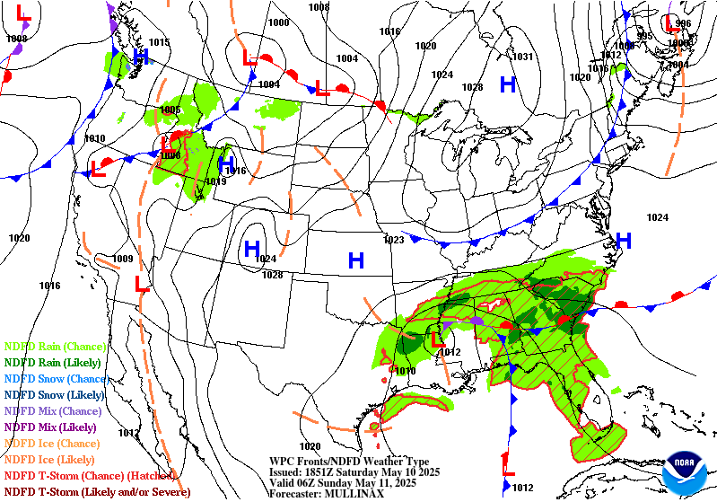
Valid 12Z Sun May 11 2025 - 12Z Mon May 12 2025
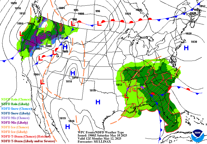
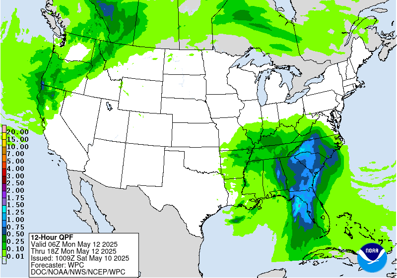
...THERE IS A SLIGHT RISK OF EXCESSIVE RAINFALL OVER PORTIONS OF
THE SOUTHEAST...
The upper level low over the Central Gulf Coast will elongate
north-south as another upper level wave of energy moves over the
Southeast on Sunday, and the direction of the mean layer flow will
shift to become more directly onshore/perpendicular to the Gulf
Coast. Meanwhile, a strengthening southern stream jet will create
favorable divergence aloft in the left exit region positioned right
over North Florida and southern Georgia in the afternoon/evening.
At the surface, an occluded low pressure system will be very slowly
moving north across the Southeast with a stationary front
extending west to east across Georgia and South Carolina. This
setup will support another wave of widespread showers and
thunderstorms capable of producing heavy rain. Much of the region
will have received heavy rain the day before (Saturday), resulting
in more saturated soils that are potentially easier to flood.
There is good agreement among models of widespread 2-3 inch totals
through the period for North Florida and southern and central
Georgia, with locally higher amounts up to 4+ inches possible. Hi-
res CAMs (available through the first half of the period) suggest
that storms developing Sunday afternoon will have the potential to
produce rain rates of 2+ inches per hour. Given the moist, unstable
air mass in place, some stronger/deep thunderstorms will be
possible as well that could contribute to rain rates exceeding the
1 and 3 hr FFGs of 3-4 inches. Some global models (mainly the ECMWF
and CMC) are suggesting high moisture pushing even further inland
with rainfall totals of 2-4 inches potentially reaching into
western North Carolina along the upslope region of the southern
Appalachians. Some heavy rainfall potential will also exist across
portions of Mississippi and Alabama where showers and storms may
develop in the vicinity of the surface low pressure center. A broad
Marginal Risk is in place from northern Mississippi through much of
Alabama to South Carolina and western North Carolina and for
portions of Central Florida. There is an embedded Slight Risk area
for North Florida, southern and central Georgia, and portions of
eastern Alabama and southern South Carolina, which covers areas
with the highest rain rate/flash flood potential.
Dolan
Day 2 threat area:
www.wpc.ncep.noaa.gov/qpf/98epoints.txt
Excessive Rainfall Discussion
NWS Weather Prediction Center College Park MD
353 AM EDT Sat May 10 2025
Day 3
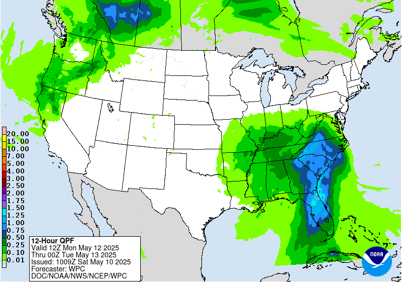
Valid 12Z Mon May 12 2025 - 12Z Tue May 13 2025
...THERE IS A SLIGHT RISK OF EXCESSIVE RAINFALL OVER PORTIONS OF
THE SOUTHEAST AND SOUTHERN MID-ATLANTIC...
The upper low that will impact the Southeast over the weekend will
finally gain some momentum and move north towards the Tennessee
Valley on Monday. The accompanying surface low pressure system will
slowly drift north as well, and moisture ahead of the system will
expand from the Southeast into the southern Mid-Atlantic. Very high
PWAT values of 1.5-2 inches will spread up the Southeast Atlantic
Coast, and widespread heavy rain is forecast from Florida to
Virginia.
Inland areas in the upslope region of the Appalachians have lower
FFGs in the rage of 2.5-3 inches per 6 hours while FFGs elsewhere
are a bit higher at 3-4+ inches per 6 hours. The synoptic setup
with prolonged onshore flow from the Atlantic will favor enhanced
rainfall along the southern Appalachians, which is observed in
model output from all available global models. There will be a high
chance for 2-3 inches of rain, with potential for up to 4 inches,
from northern Georgia to southern Virginia, which would likely
cause at least scattered flash flooding concerns. High rainfall
totals will also be possible in convergent areas along the coast
from Florida to North Carolina, and 24 hour QPF totals are forecast
to reach 1.5-2 inches with locally higher amounts expected with
stronger convection. Many areas from Florida to South Carolina will
have already received heavy rain over the weekend, which will
increase the chance of flash flooding concerns with additional
heavy rain on Monday. There is a fairly large Slight Risk area in
place to cover the higher rainfall potential from Central and North
Florida through eastern Georgia and the Carolinas to southern
Virginia. The highest risk area within this region will be the
southern Appalachians, which will need to be monitored in future
forecast updates for potential ERO upgrades. Surrounding the Slight
Risk area, a Marginal is in place from Florida to Virginia.
Dolan
Day 3 threat area:
www.wpc.ncep.noaa.gov/qpf/99epoints.txt
Extended Forecast Discussion
NWS Weather Prediction Center College Park MD
254 AM EDT Sat May 10 2025
The slow moving occluded surface low and associated upper low will
result in a strong northward influx of deep moisture and result in
multiple sustained rounds of moderate to heavy rainfall extending
from northern Florida to the Mid-Atlantic region. In particular,
enhanced moisture flux with upslope component across the southern
Appalachians on Tuesday (Day 4) will likely result in higher
rainfall totals across central/eastern North Carolina northward to
central and western Virginia. Given low-mid level southeasterly
flow directed towards the Blue Ridge, some enhanced rainfall totals
will be possible here and the latest model guidance depicts this
scenario well. Some cells with hourly rainfall rates in excess of
an inch are likely, and therefore a Slight Risk area has been
introduced for Day 4. The system weakens further and moisture
convergence lessens going into Wednesday (Day 5), so no risk areas
are currently warranted for that time.
Out West, rain and higher elevation snows will become more
widespread into next week with the amplified upper low passing
through. This especially holds true for the northern Rockies going
into the middle of next week with some of the higher ranges
picking up enhanced late season snowfall, possibly over a foot in
some cases across southwestern Montana. As the system progresses
east, moderate to heavy rainfall may develop to the northwest of a
surface low over the Dakotas, and given the potential for some 1-2
inch rainfall totals on Wednesday, a Marginal Risk area is planned
for the Day 5 period.
An early season heatwave is likely across the Dakotas and into
Minnesota early in the week as this region will be in the warm
sector of a developing surface low. Temperatures will be the
warmest of the season thus far with highs reaching the middle 80s
to lower 90s, which is at least 20 degrees above average for this
time of year and easily setting some daily record highs. It will
also be hot across much of Texas with some 100+ degree readings
expected near the Rio Grande. Warmer temperatures are also coming
to much of the Eastern U.S. by the end of the week, with humidity
levels also increasing. In contrast, unseasonably cool and
unsettled conditions are forecast for the Intermountain West with
the amplified upper trough moving in, with highs running 10-20
degrees below mid-May averages in some cases.
Hamrick


