Excessive Rainfall Discussion
NWS Weather Prediction Center College Park MD
429 PM EDT Sun May 11 2025
Day 1
Valid 16Z Sun May 11 2025 - 12Z Mon May 12 2025
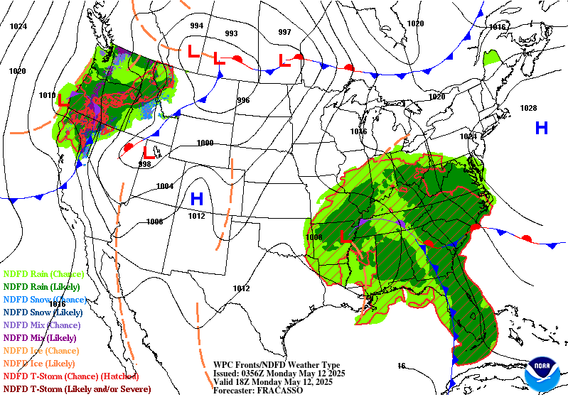
...THERE IS A SLIGHT RISK OF EXCESSIVE RAINFALL OVER MUCH OF THE
SOUTHEAST...
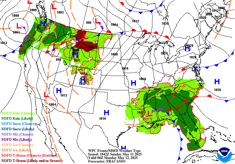
16z Update: The best signal for isolated to scattered flash
flooding this afternoon/evening appears to be over portions of
southeast GA into northeast FL where backbuilding cells will result
in rainfall locally over 3 inches. In fact both 12z HREF and 06z
REFS neighborhood probabilities of exceeding 5" are over 50%, and
if/where this occurs would expect at least some minor flood
concerns to develop.
By this afternoon convection should develop over portions of
central AL into MS closer to the deep layer low center. This
activity will also likely exhibit some training/backbuilding
characteristics resulting in an isolated to scattered flash flood
risk. Some localized exceedance of 3" appear probable here, and
both the HREF and REFS indicate some FFG exceedance probs as well.
The Slight risk was expanded a bit to the west to account for this
activity over MS.
The northern edge of the Slight risk over the Carolinas was
tightened a bit as the main flash flood risk here will likely be
on day 2 (after 12z Monday). The Marginal risk was expanded
southward to include the rest of the FL peninsula as slow moving
convection may try to move into south FL overnight.
Chenard
...Previous Discussion...
A stationary upper low will remain positioned over the Central
Gulf Coast today while waves of upper level energy pivot around it
over the Southeast. The low is expected to become slightly
elongated north to south, resulting in strong southerly mean flow
that will pump moisture from the Gulf directly into the Southeast.
Additionally, a southern stream jet is forecast to strengthen over
the northern Gulf, creating favorable upper level divergence over
North Florida and Georgia to support widespread shower and
thunderstorm development. At the surface, an occluded low pressure
system will be slowly moving north across the region, with a cold
front extending south across the Florida Panhandle and a stationary
front extending east across Georgia and South Carolina. The best
conditions for heavy rain will be in the warm sector over North
Florida and southern Georgia, but heavy rainfall will also be
possible along and north of the stationary boundary up into
portions of the Carolinas.
With plentiful moisture (PWATs 1.5-2+ inches) and instability
(MUCAPE 1500-2000+ J/kg), storms in the warm sector will be capable
of producing 2-3+ inch per hour rain rates from Florida to South
Carolina, which could lead to some flash flooding concerns given
2-3 inch per hour FFGs. Flash flooding may also be a concern back
into portions of Alabama and northern Mississippi where there will
likely be enough moisture and instability in the vicinity of the
surface low to produce showers and storms with 2+ inch per hour
rain rates. Previous heavy rains have already saturated soils from
Mississippi to Georgia, which will make these areas more sensitive
to flooding with additional heavy rain today. To account for this
flood potential there is a Slight Risk of excessive rainfall in
place for much of the Southeast, including areas from North Florida
to southern North Carolina and much of Alabama and northern
Mississippi. The Slight Risk area is encompassed by a broader
Marginal Risk that includes much of the Tennessee Valley, eastern
Arkansas, upslope regions of the southern Appalachians, and Central
Florida.
Dolan
Day 1 threat area:
www.wpc.ncep.noaa.gov/qpf/94epoints.txt
Excessive Rainfall Discussion
NWS Weather Prediction Center College Park MD
429 PM EDT Sun May 11 2025
Day 2
Valid 12Z Mon May 12 2025 - 12Z Tue May 13 2025
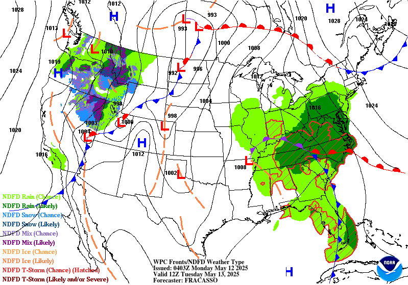
...THERE IS A SLIGHT RISK OF EXCESSIVE RAINFALL OVER PORTIONS OF
THE SOUTHEAST AND SOUTHERN MID-ATLANTIC...
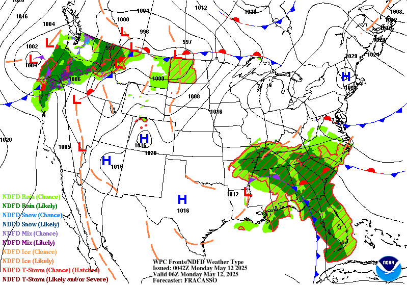
20z Update: Continue to be very close to needing a MDT risk
upgrade across the upslope areas of the southern Appalachians, but
we will hold at a higher end Slight risk for now. Orographically
enhanced rainfall and embedded convective elements periodically
pushing rainfall rates over 1"/hr will likely drive at least a
minor flash flood risk across this portion of the western
Carolinas and southwest VA. However confidence on seeing more
significant higher end impacts remains lower. With easterly low
level flow in place over this corridor the better instability may
tend to stay farther south over GA/SC and over the eastern
Carolinas. Probabilities of exceeding 1"/hr in the HREF peak
around 40-50% in the 12z HREF and REFS, likely indicative of some
exceedance, but probably not widespread. It will likely take these
higher rates of 1-2"/hr or greater to drive more significant
impacts.
The currently forecast 3-7" of rainfall, combined with
embedded rates of 0.5"-1"/hr should be enough to drive at least
scattered instances of minor flash flooding, with localized more
significant impacts still possible. For now the expectation of
scattered minor flash flood and localized higher end impacts falls
more into the high end Slight risk category. If confidence in
greater coverage of higher rainfall rates increases, that would in
turn increase the potential for higher end impacts and justify a
MDT risk upgrade. Will thus continue to closely monitor.
The southeastern FL urban corridor is another area of concern for
flash flooding Monday. Neighborhood probability of exceeding 8"
are over 50% in both the 12z HREF and REFS and some deterministic
members are over 10". Overall seems like a favorable synoptic
setup for training convection and thus higher end urban impacts
are possible. Not confident enough yet to go with a MDT risk
upgrade, however do consider this a higher end Slight risk and the
potential is certainly there for significant urban impacts. We
will continue to monitor observational and model trends.
Chenard
...Previous Discussion...
The nearly stationary upper low that impacted the Southeast over
the weekend will finally gain some momentum and shift north towards
the Tennessee Valley on Monday, pulling the surface low pressure
system along with it. The trailing cold front will gradually push
towards the Southeast Atlantic Coast while the warm front lifts
into the southern Mid-Atlantic, and another round of widespread
showers and storms are forecast Monday into Monday night in the
warm sector of the system. Deep moisture will surge north ahead of
the cold front, extending from Florida through the Carolinas to
southern and central Virginia. PWATs are anticipated to reach
1.5-2+ inches in these areas with even higher values possible over
the Florida Peninsula. Strong south-southeasterly mean flow will
remain in place, which will likely result in two convergent zones,
one along the Southeast Coast and one along upslope regions of the
southern Appalachians where high QPF totals will be possible.
Strong diurnal convection over the Florida Peninsula will also
contribute to high QPF values over portions of Central and South
Florida.
The largest flooding concerns will come with repeat/training
activity, which could result in high QPF totals over a relatively
short period of time, potentially reaching or exceeding the 1 and 3
hour FFGs in these regions. To account for this flash flood risk,
there is a Slight Risk area stretching from Florida up the
Southeast Coast to North Carolina and southern Virginia and also
for the upslope regions of the Appalachians from Georgia to
Virginia. A Marginal Risk area extends even further into the Mid-
Atlantic where moderate rain rates may contribute to localized
flash flooding and into the Tennessee and Mid-Mississippi Valleys
where enough moisture will likely wrap around the surface low to
create locally heavy rainfall in showers and storms.
Upslope regions of the southern Appalachians are particularly
sensitive to heavy rain, especially in areas that were impacted by
Hurricane Helene. Impacts from heavy rain on Monday will likely
fall into the high-end Slight Risk category, and ERO upgrades may
be needed in the future if high QPF trends hold,. However,
instability may be a limiting factor as the better instability is
expected to reside along the coast. After coordinating with local
forecast offices, it was decided to hold off on any upgrades at
this time. By this afternoon, the CAMs will go out far enough to
cover the entire Day 2 period and will likely give us a better idea
of the magnitude of potential flooding impacts.
Dolan
Day 2 threat area:
www.wpc.ncep.noaa.gov/qpf/98epoints.txt
Excessive Rainfall Discussion
NWS Weather Prediction Center College Park MD
429 PM EDT Sun May 11 2025
Day 3
Valid 12Z Tue May 13 2025 - 12Z Wed May 14 2025
...THERE IS A SLIGHT RISK OF EXCESSIVE RAINFALL OVER PORTIONS OF
THE MID-ATLANTIC...
20z Update: The Slight and Marginal risk areas were expanded a bit
to the west with this update. The Marginal risk covers more of the
OH valley where slow moving convection ahead of the deep layered
low could result in localized flash flooding. The Slight risk is
expanded into more of the central Appalachians. Overall still
looks like a solid Slight risk from northeast NC into the portions
of eastern WV. Convection near a stalled boundary should result in
an isolated to scattered flash flood risk. Will need to closely
monitor, as the slow moving closed low and a stationary boundary
does suggests some higher end impact potential Tuesday within the
Slight risk area.
Chenard
...Previous Discussion...
The slow-moving upper low and occluded surface low will continue
to move north, triggering showers and storms across the Mid-
Atlantic on Tuesday. A deep stream of moisture ahead of the system
will push PWAT values above 1.5 inches, and there will be enough
instability (MUCAPE > 1500 J/kg) across portions of North Carolina
and Virginia to support high rain rates in showers and storms. It
seems likely that rain rates could reach or exceed the 1-2 inch per
hour FFGs in Central Virginia (especially in upslope and urban
areas), and possibly the 2.5-3 inch per hour FFGs in southern
Virginia and northeastern North Carolina as well. Models have been
picking up on a faster trend with this system, but there is some
uncertainty in how fast or slow it will move. This will affect the
location of the heaviest rainfall in the warm sector and
along/ahead of the cold front. The general consensus is for the
highest totals to fall over Virginia and northern North Carolina,
but some models are advancing heavy rain even further north.
To account for the faster trend in guidance, the inherited Slight
and Marginal Risk areas from the previous Day 4 ERO have been
shifted north, with the Marginal extending up into portions of
Pennsylvania and New Jersey. The southern edge of the Slight Risk
area has been trimmed up to match QPF trends, and it was extended
east to coastal Virginia where urban areas tend to be more
sensitive to heavy rain and flooding. It's possible that the
location of the Slight Risk will shift in future updates as the
speed of the system becomes more certain.
Dolan
Day 3 threat area:
www.wpc.ncep.noaa.gov/qpf/99epoints.txt
Extended Forecast Discussion
NWS Weather Prediction Center College Park MD
253 PM EDT Sun May 11 2025
The region with heaviest rainfall going into the second half of the
work week will be across the Northern Plains on the back side of
the developing surface low. Although rainfall rates are not
expected to be all that high, multiple hours of moderate rainfall
with rates of half an inch per hour in some cases may just be
enough to cause some minor flooding issues in vulnerable areas, and
therefore the Marginal Risk area has been maintained for Wednesday
(Day 4) from eastern Montana into western North Dakota. Going into
Thursday (Day 5), the heavier rainfall reaches eastern North Dakota
into northern Minnesota where a Marginal Risk area is now planned,
with some of the guidance indicating the potential for 1-2 inch
rainfall totals with some embedded convection.
Elsewhere across the nation, explicit QPF has recently trended a
little lower for the Mid-Atlantic region for Wednesday as the
forcing associated with the upper low weakens and convection is
more scattered and less organized. After recent consultation with
affected WFOs, a prior issued WPC ERO Marginal Risk threat area was
dropped for the Day 4/Wednesday period. However, lingering moisture
and slow translation of remaining activity could be locally
problematic for areas the end up getting precursor heavy rainfall.
The Storm Prediction Center shows a threat for some severe storms
on Thursday across portions of the Midwest. Out West, Old Man
Winter will continue to make its presence known across the Northern
Rockies with heavy snow for the highest ranges of southwestern
Montana and northern Wyoming, with the potential for 6-12 inches of
accumulation in some cases. Lighter snows are likely elsewhere for
higher terrain of the Northern Rockies and Intermountain West.
Very warm weather will continue across the Upper Midwest for the
middle of the week, with highs reaching 85-90 degrees on Wednesday
across the eastern Dakotas and much of Minnesota. The anomalous
warmth then shifts eastward to the Great Lakes and Ohio Valley
regions to close out the week, and much of the East Coast Friday
into Saturday ahead of the cold front. Very hot conditions are
expected across southern Texas for the entire forecast period with
highs exceeding 100 degrees near the Rio Grande, and HeatRisk
reaching the major category for these areas. In contrast, chilly
conditions are likely for the Intermountain West and Northern
Rockies with highs running 5-15 degrees below average with the
upper level trough and increased cloud cover.
Hamrick/Schichtel


