Excessive Rainfall Discussion
NWS Weather Prediction Center College Park MD
1136 AM EDT Tue May 13 2025
Day 1
Valid 16Z Tue May 13 2025 - 12Z Wed May 14 2025
...THERE IS A SLIGHT RISK OF EXCESSIVE RAINFALL OVER PORTIONS OF
THE MID-ATLANTIC...
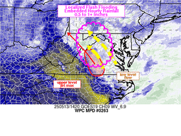
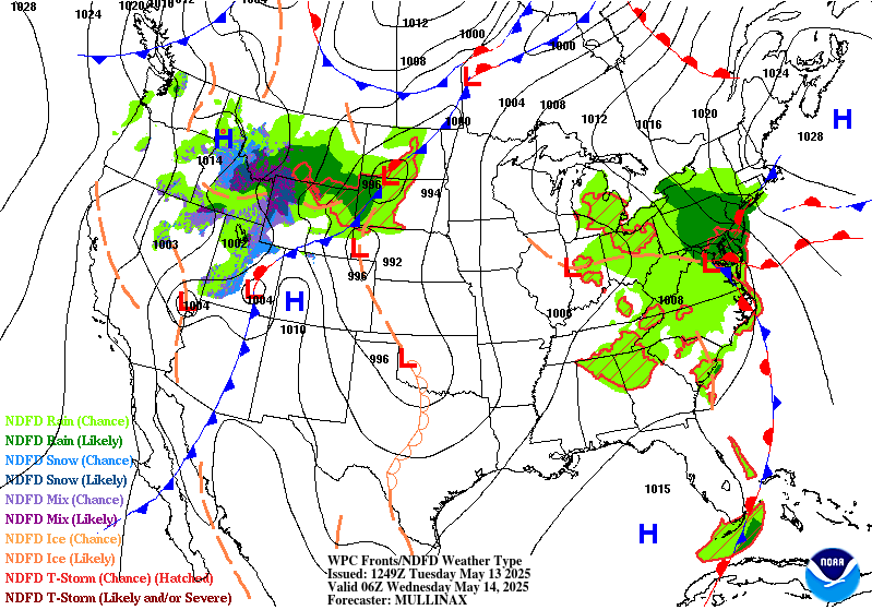
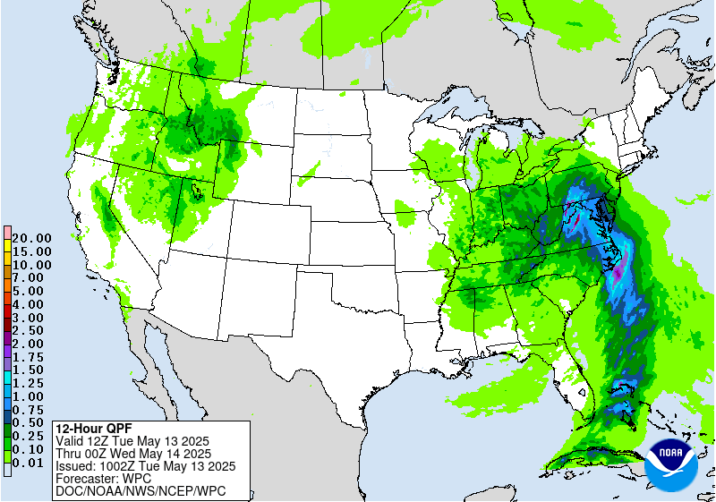
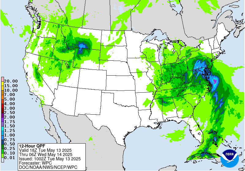
16Z Update: The overall synoptic pattern remains unchanged with the
progression at both the surface and upper levels maintaining run to
run continuity within the hi-res suite. Steady plume of moisture
between 925-500mb will aid in continued moderate to heavy rain
signature across the Mid Atlantic with a stronger convective focus
situated across the Southern Mid Atlantic and Blue Ridge due to
some marginal clearing as dry air advects aloft under the base of
the upper low. Current IVT orientation remains sufficient for
primed easterly upslope across the Central and Northern Blue Ridge
with waves of heavier QPF migrating west-northwest from the Potomac
to points west. Latitudinal push of heavier precip will occur this
evening as the surface low develops across Eastern NC and moves
just offshore towards the VA Capes by the morning. This will align
the moisture advection pattern a bit further north putting areas
from Central and Eastern PA down into the Central Mid Atlantic
urban centers and Delmarva into play for some of the heavier echoes
anticipated with the setup. The jury is still out on whether the
rates will be sufficient for the Balt/DC metro area during the
forecast, but the urbanization factors are a lean towards
maintaining continuity as any significant rainfall cores and
training echoes could cause some flash flood concerns east of US15.
12z HREF neighborhood probs for >3" are very high (>70%) within the
Central Blue Ridge up into the Lower Susquehanna Valley and eastern
slopes of the Laurels. Pockets of elevated probs (>50%) are present
for >5" totals as well within the same corridor with the highest
centered over the Blue Ridge thanks to the textbook easterly
upslope signature within a core of higher IVT in conjunction with a
reasonable theta_E maxima that aligns with the terrain. This has
allowed for a general maintenance of the SLGT risk inherited with
only minor modifications based on QPF output via latest HREF
blended mean and prob fields.
Secondary and tertiary QPF maxima are positioned within the Ohio
Valley and portions of Eastern NC due to the proxy of the ULL and
modest buoyancy under the low center for the OV, and persistent
onshore component over Eastern NC during the first half of the
forecast period. Widespread MRGL risk encompasses the SLGT across
much of the Ohio Valley down into parts of the Southeast as
isolated convection pivots around the ULL with some repeated cell
impacts plausible given the slower mean storm motions under the
primary ULL.
Kleebauer
..Previous Discussion..
A closed upper low will gradually lift north over the Tennessee
and Ohio Valleys, accompanied by a very slow-moving surface low
pressure system. A stream of deep Gulf/Atlantic moisture will move
into the Mid-Atlantic ahead of the system, increasing PWAT values
to 1.5-2 inches. There will be enough instability (MUCAPE > 1500
J/kg) to support thunderstorm development, some of which may be
strong/deep. The best chances for deep convection with high rain
rates (1-2 inches) will likely be over portions of Virginia and
eastern North Carolina where higher instability will reside, but
persistent upslope enhancement will also contribute to elevated
rain rates over portions of the Appalachians from central and
southern Pennsylvania to Virginia. These areas will likely see 1-3
inches of rainfall today, with locally higher amounts in terrain
and heavier convection. Heavy rain will have the potential to
create isolated to scattered flooding concerns across these areas,
warranting a Slight Risk of excessive rainfall.
Elsewhere, a Marginal Risk of excessive rainfall is in effect for
the Ohio Valley and portions of the Tennessee Valley and interior
Southeast where scattered diurnal convection is expected underneath
the upper low. Slow storm motion will contribute to elevated rain
rates (1+ inch per hour) that could reach or exceed 1 and 3 hour
FFGs (1-2 inches). Given that soils in these areas are already
saturated from recent heavy rain, these rain rates could create
isolated instances of flash flooding.
Dolan
Day 1 threat area:
www.wpc.ncep.noaa.gov/qpf/94epoints.txt
Excessive Rainfall Discussion
NWS Weather Prediction Center College Park MD
1136 AM EDT Tue May 13 2025
Day 2
Valid 12Z Wed May 14 2025 - 12Z Thu May 15 2025
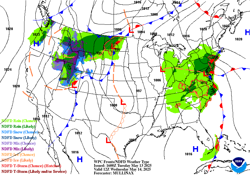
...THERE IS A MARGINAL RISK OF EXCESSIVE RAINFALL OVER PORTIONS OF
THE NORTHERN PLAINS AND MID-ATLANTIC...
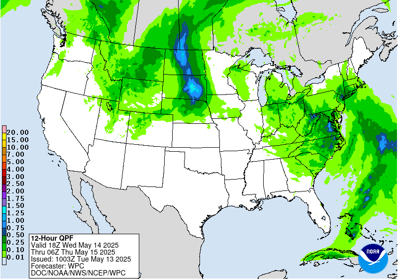
...Northern Plains...
A deep upper level trough will push across the northern Rockies
into the northern Plains late Tuesday into Wednesday, resulting in
a strengthening low pressure system tracking from Wyoming through
North Dakota. Stratiform rain with some embedded convection is
expected on the northern and western side of the low, which should
result in a swath of 0.5-1+ inches of rainfall across central and
eastern Montana on Wednesday. Storm total rainfall will be higher
across Montana due to additional rain falling at the end of the Day
1 period (Tuesday night). The main concern with this activity will
be the duration, with rainfall rates potentially reaching 6 hour
FFGs. This could support isolated flash and river flooding
concerns.
Over the Dakotas, convection is expected to develop along a
strengthening cold front that will push east across the region.
With favorable upper level and surface support, some convection may
be deep enough to produce 1+ inch per hour rain rates that could
reach or exceed the 1 and 3 hr FFGs (around 1.5-2.5 inches).
Conditions will be supportive of localized heavy rain in stronger
convection/thunderstorms, with plentiful moisture (PWATs 1-1.5
inches) and instability (CAPE > 1500 J/kg) in place. The Marginal
Risk of excessive rainfall in the northern Plains includes portions
of Montana and the Dakotas where isolated to potentially scattered
instances of flash flooding will be possible. It's possible an
upgrade may be needed for the Dakotas if precip rates and QPF trend
higher, but we should have a better idea of potential impacts once
the period is fully within range of the CAMs.
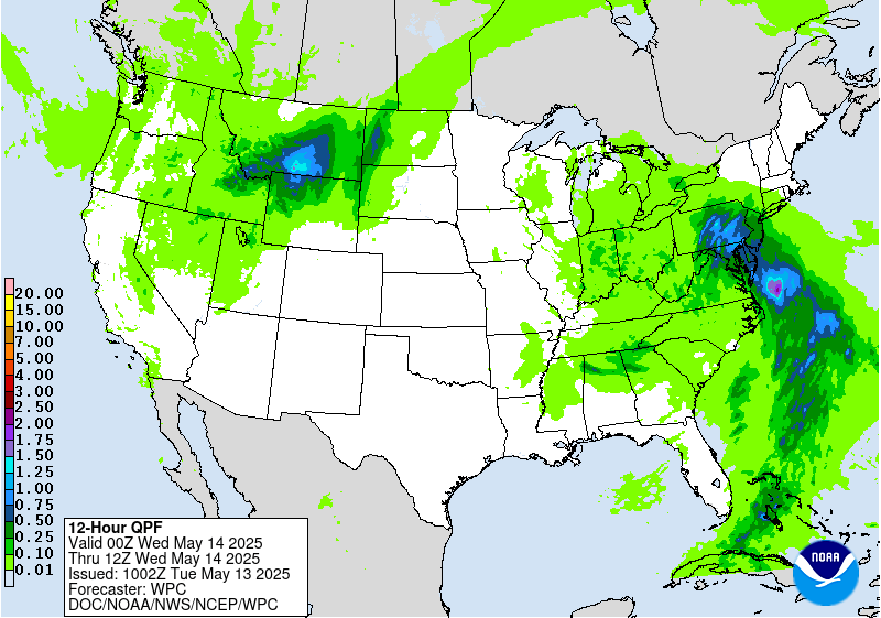
...Mid-Atlantic...
Soils are expected to be thoroughly saturated across the Mid-
Atlantic by Wednesday due to heavy rain earlier in the week, which
will likely result in a lingering flash flood threat on Wednesday.
The slow-moving surface low is forecast to become nearly stationary
over the region while gradually weakening, resulting in scattered
precipitation through Wednesday night. Enough moisture and
instability are expected in the vicinity of the surface low to
support convection with relatively higher rain rates that could
lead to flooding. The 00Z HREF shows a high probability (60-80%) of
1 inch per hour rain rates from the Maryland and West Virginia
Panhandles through Virginia to eastern North Carolina and even a
low/isolated probability (~20%) of 2 inch per hour rain rates. A
Marginal Risk is in place from southern Pennsylvania through North
Carolina to northeast South Carolina to account for this flood
potential.
Dolan
Day 2 threat area:
www.wpc.ncep.noaa.gov/qpf/98epoints.txt
Excessive Rainfall Discussion
NWS Weather Prediction Center College Park MD
1136 AM EDT Tue May 13 2025
Day 3
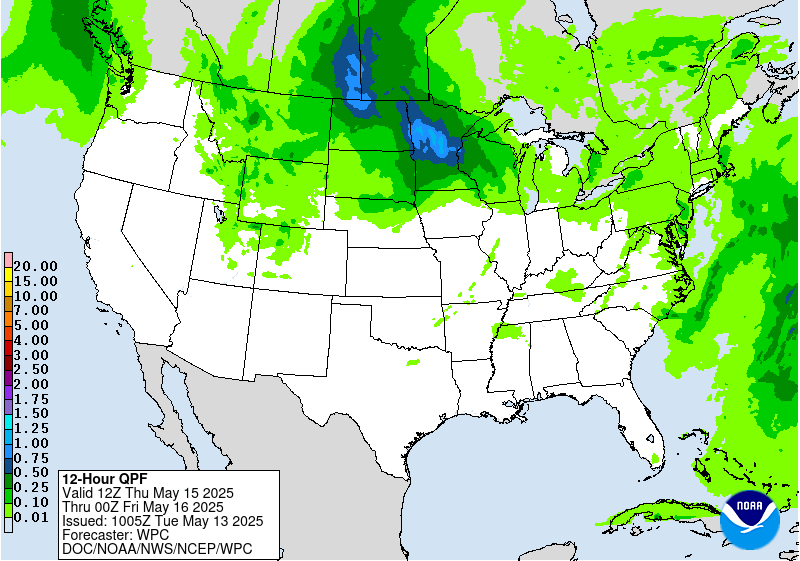
Valid 12Z Thu May 15 2025 - 12Z Fri May 16 2025
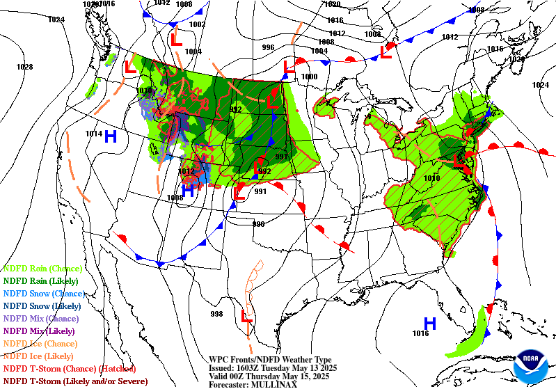
...THERE IS A MARGINAL RISK OF EXCESSIVE RAINFALL OVER PORTIONS OF
THE UPPER MIDWEST AND NORTHERN PLAINS...
An occluded low pressure system will lift northeast across the
Upper Midwest, with showers and storms ahead of the occluded and
cold fronts and some precipitation wrapping around the backside of
the system into the northern Plains as well. Slow storm motion and
repeat activity look like they will be the main threat, which may
result in rain rates that may reach or exceed the 3 hour FFGs.
There will be plenty of moisture in place to support elevated rain
rates with PWAT values reaching 1-1.5 inches. However, instability
may be a limiting factor. The best instability is expected to be
further south along the cold front, displaced from the higher QPF
values. Based on available guidance, a Marginal Risk area should
suffice to account for the low end flash flood potential.
Precipitation is forecast to extend across the Great Lakes region
as well, but rain rates will likely be moderate at best, not
supporting a flash flood threat at this time.
Dolan
Day 3 threat area:
www.wpc.ncep.noaa.gov/qpf/99epoints.txt
Extended Forecast Discussion
NWS Weather Prediction Center College Park MD
258 AM EDT Tue May 13 2025
Showers and thunderstorms increase in coverage and intensity
across the Mid-South and Ohio Valley ahead of a cold front that
will be intercepting deeper return moisture. An ERO Marginal Risk
area remains valid for Friday (Day 4) from Arkansas to the central
Appalachians, with an expansion northward to include southern
portions of Illinois, Indiana, and Ohio where the 00Z guidance has
trended heavier with expected rainfall. Going into Saturday (Day 5)
attention then turns to portions of the southern Plains and
extending to the Mid-South with enhanced moisture convergence near
the same frontal boundary and ahead of a developing wave of low
pressure near the Texas Panhandle.
Elsewhere across the nation, the Storm Prediction Center is
monitoring the potential for severe weather from the Midwest to the
Mid-South to close out the work week with favorable instability and
kinematics. Across the Rockies, expect additional chances for late
season snow for the central and northern Rockies by Sunday into
Monday
as the next upper trough and shortwave moves in, with the potential
for over a foot of accumulation for some of the highest mountain
ranges. Numerous showers are also likely to develop across the
Great Basin over the weekend in response to the developing upper
low, and this may become locally heavy enough to eventually need a
Marginal Risk area for excessive rainfall as the event gets closer.
Very warm weather will be commonplace across the eastern half of
the country to close out the work week, with highs well into the
80s and even some lower-middle 90s from the Ohio Valley and Mid-
Atlantic southward to the Gulf Coast. Very hot conditions are
expected across southern Texas through the upcoming weekend with
highs exceeding 100 degrees near the Rio Grande and into much of
central Texas, and HeatRisk reaching the major to extreme category
for some of these areas. In contrast, chilly conditions are likely
for the Intermountain West and Northern Rockies/Plains with highs
running 10 to perhaps 20 degrees below average with the upper level
trough and increased cloud cover.
Hamrick


