Excessive Rainfall Discussion
NWS Weather Prediction Center College Park MD
335 PM EDT Tue May 13 2025
Day 1
Valid 16Z Tue May 13 2025 - 12Z Wed May 14 2025
...THERE IS A SLIGHT RISK OF EXCESSIVE RAINFALL OVER PORTIONS OF
THE MID-ATLANTIC...
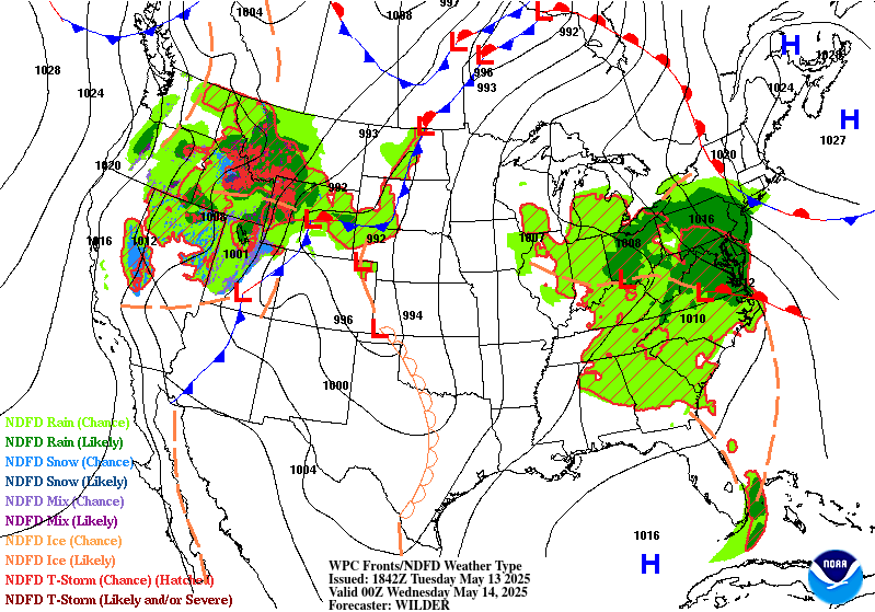
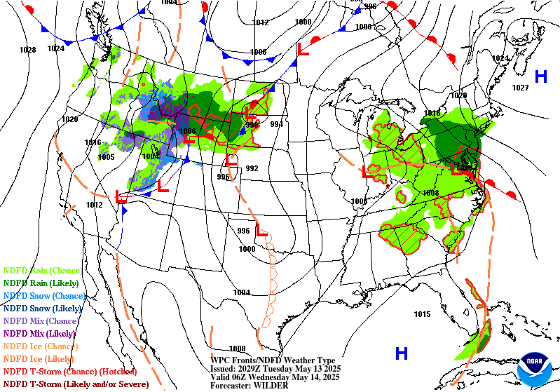
16Z Update: The overall synoptic pattern remains unchanged with the
progression at both the surface and upper levels maintaining run to
run continuity within the hi-res suite. Steady plume of moisture
between 925-500mb will aid in continued moderate to heavy rain
signature across the Mid Atlantic with a stronger convective focus
situated across the Southern Mid Atlantic and Blue Ridge due to
some marginal clearing as dry air advects aloft under the base of
the upper low. Current IVT orientation remains sufficient for
primed easterly upslope across the Central and Northern Blue Ridge
with waves of heavier QPF migrating west-northwest from the Potomac
to points west. Latitudinal push of heavier precip will occur this
evening as the surface low develops across Eastern NC and moves
just offshore towards the VA Capes by the morning. This will align
the moisture advection pattern a bit further north putting areas
from Central and Eastern PA down into the Central Mid Atlantic
urban centers and Delmarva into play for some of the heavier echoes
anticipated with the setup. The jury is still out on whether the
rates will be sufficient for the Balt/DC metro area during the
forecast, but the urbanization factors are a lean towards
maintaining continuity as any significant rainfall cores and
training echoes could cause some flash flood concerns east of US15.
12z HREF neighborhood probs for >3" are very high (>70%) within the
Central Blue Ridge up into the Lower Susquehanna Valley and eastern
slopes of the Laurels. Pockets of elevated probs (>50%) are present
for >5" totals as well within the same corridor with the highest
centered over the Blue Ridge thanks to the textbook easterly
upslope signature within a core of higher IVT in conjunction with a
reasonable theta_E maxima that aligns with the terrain. This has
allowed for a general maintenance of the SLGT risk inherited with
only minor modifications based on QPF output via latest HREF
blended mean and prob fields.
Secondary and tertiary QPF maxima are positioned within the Ohio
Valley and portions of Eastern NC due to the proxy of the ULL and
modest buoyancy under the low center for the OV, and persistent
onshore component over Eastern NC during the first half of the
forecast period. Widespread MRGL risk encompasses the SLGT across
much of the Ohio Valley down into parts of the Southeast as
isolated convection pivots around the ULL with some repeated cell
impacts plausible given the slower mean storm motions under the
primary ULL.
Kleebauer
..Previous Discussion..
A closed upper low will gradually lift north over the Tennessee
and Ohio Valleys, accompanied by a very slow-moving surface low
pressure system. A stream of deep Gulf/Atlantic moisture will move
into the Mid-Atlantic ahead of the system, increasing PWAT values
to 1.5-2 inches. There will be enough instability (MUCAPE > 1500
J/kg) to support thunderstorm development, some of which may be
strong/deep. The best chances for deep convection with high rain
rates (1-2 inches) will likely be over portions of Virginia and
eastern North Carolina where higher instability will reside, but
persistent upslope enhancement will also contribute to elevated
rain rates over portions of the Appalachians from central and
southern Pennsylvania to Virginia. These areas will likely see 1-3
inches of rainfall today, with locally higher amounts in terrain
and heavier convection. Heavy rain will have the potential to
create isolated to scattered flooding concerns across these areas,
warranting a Slight Risk of excessive rainfall.
Elsewhere, a Marginal Risk of excessive rainfall is in effect for
the Ohio Valley and portions of the Tennessee Valley and interior
Southeast where scattered diurnal convection is expected underneath
the upper low. Slow storm motion will contribute to elevated rain
rates (1+ inch per hour) that could reach or exceed 1 and 3 hour
FFGs (1-2 inches). Given that soils in these areas are already
saturated from recent heavy rain, these rain rates could create
isolated instances of flash flooding.
Dolan
Day 1 threat area:
www.wpc.ncep.noaa.gov/qpf/94epoints.txt
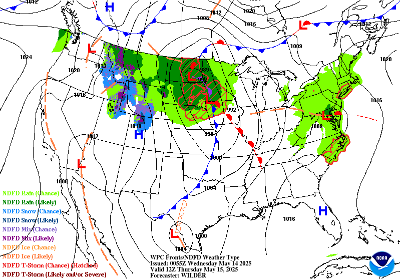
Excessive Rainfall Discussion
NWS Weather Prediction Center College Park MD
335 PM EDT Tue May 13 2025
Day 2
Valid 12Z Wed May 14 2025 - 12Z Thu May 15 2025
...THERE IS A SLIGHT RISK OF EXCESSIVE RAINFALL OVER PORTIONS OF
THE NORTHERN PLAINS...
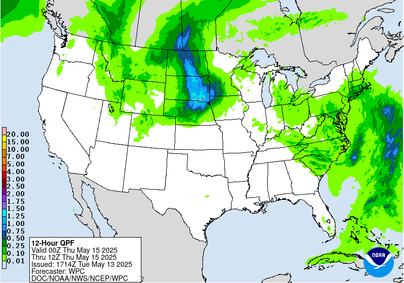
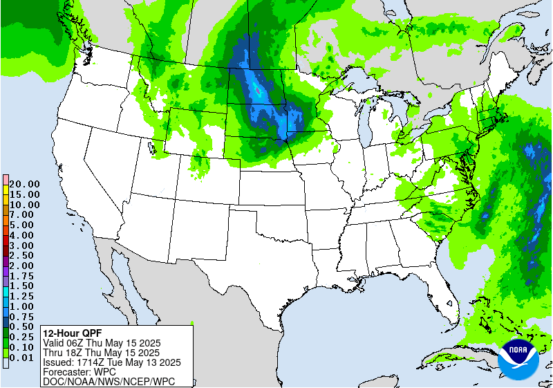
...Northern Plains...
20Z Update: The newest update has added a regional SLGT risk across
portions of North and South Dakota along with the northern fringes
of Nebraska. The setup will yield a multi-round period of
convection within an amplifying mid-level pattern where strong
mid and upper ascent will couple with a persistent north-south
oriented surface trough bisecting the Dakotas. Afternoon
destabilization within the confines of a sharpening surface trough
will lead to scattered convection with slow storm motions as the
mesocyclones will likely be anchored to the boundary in question.
Theta_E gradient is well advertised outlining the general
positioning of the surface trough within all major deterministic
with boundary layer flow showing a primed convergence pattern in-of
the boundary. MUCAPE between 1000-2000 J/kg will provide ample
instability for strengthening updraft capabilities which will
ultimately tap into an improving moisture advection regime
downstream of a potent shortwave trough.
The trough in question will become a larger factor for the back
half of the forecast as the trough axis will swing eastward by
late-Wednesday afternoon with an increased layer of diffluence
positioned from the northern Front Range up into the Dakotas. A
powerful vorticity maxima on the base of the trough will pivot
quickly to the northeast allowing for a broadened large scale
forcing mechanism that will trigger a widespread swath of
convection as it enters into the Northern High Plains. Guidance is
mostly in tandem with the positioning of the heaviest precip
located across central and southern SD with the convective pattern
likely to initiate and grow upscale rapidly as the activity presses
eastward. LLJ implementation overnight will only exacerbate the
threat as strengthening shear profiles via local forecast soundings
indicate an environment that will be mature quite nicely as it
advances near and over the I-80 corridor.
There will be an area where both convective schemes will align
providing the areal QPF average maxima with totals between 1.5-2.5"
likely with localized totals between 3-5" plausible where there's
the general overlap. 12z HREF EAS probs for >1" are very high
(60-80%) within a large swath of Southeast SD where the CAMs are
most bullish with the overlapped QPF distribution from both
convective patterns. A secondary maxima extends up into South-
Central ND where the primary impacts will be stronger cells in-of
the surface trough with some scattered convective elements as the
potent mid-level vorticity maxima approaches early Thursday
morning. There's still some spread on the northern extent, but the
magnitude of the potential is worthy for the implementation of a
SLGT risk up into portions of Bismarck's CWA. The SLGT is most
prominent across southern and Southeast SD where there's growing
consensus on a dual convective threat with an overlap between two
impact periods in the forecast window. A MRGL encompasses the
general SLGT with heavy precip likely to fall as far south as
Southwest NE, but consensus is forward propagation speeds should
limit the threat, especially when you add the Sandhill regions
very high FFG indices.
Kleebauer
...Mid-Atlantic...
20Z Update: Broad MRGL remains with little variation from run to
run within the recent deterministic output. CAMs continue to
pinpoint a round of convection developing under the primary upper
circulation as it maneuvers eastward through VA. The axis of
greatest impact will occur over Southeast VA up through the western
shores of the Chesapeake with a secondary maxima across Northern NJ
into the Lower Hudson of NY. The latter has a low-prob compared to
the anticipated convective threat further south due to lack of
instability and more of a steady-state stratus rainfall with some
embedded heavier rain cores. A SLGT risk was mulled over across
Southeastern VA, but CAMs differed on the magnitude and positioning
of the greatest convective potential. A targeted SLGT is possible
if future CAMs have a better handle and promote a more significant
probabilistic output for heavier rainfall potential. For now,
localized 1-2" amounts are most likely when assessing the modest
EAS signal for >1" across Eastern VA (20-35%) and a much lower >2"
signal (<5%) in the same region. The MRGL was maintained given the
above data interpretation.
Kleebauer
..Previous Discussion..
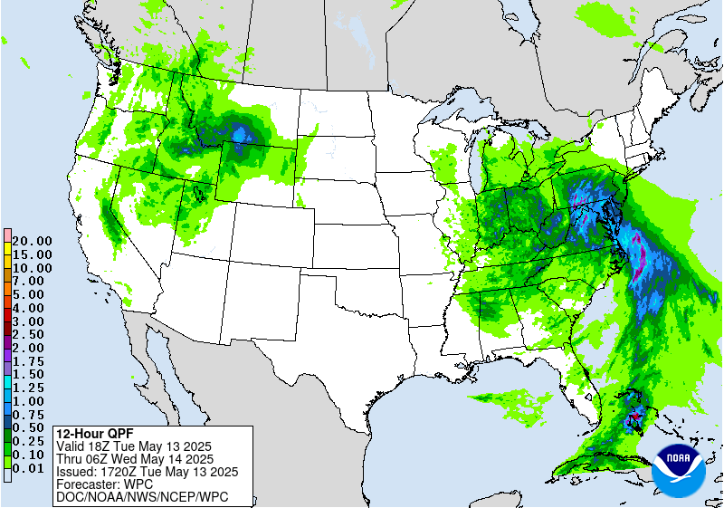
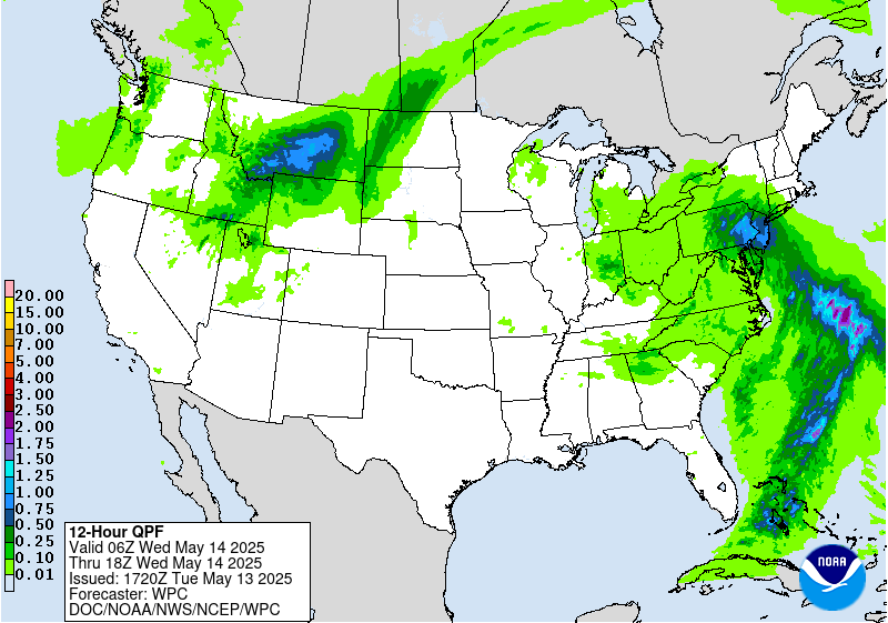
Soils are expected to be thoroughly saturated across the Mid-
Atlantic by Wednesday due to heavy rain earlier in the week, which
will likely result in a lingering flash flood threat on Wednesday.
The slow-moving surface low is forecast to become nearly stationary
over the region while gradually weakening, resulting in scattered
precipitation through Wednesday night. Enough moisture and
instability are expected in the vicinity of the surface low to
support convection with relatively higher rain rates that could
lead to flooding. The 00Z HREF shows a high probability (60-80%) of
1 inch per hour rain rates from the Maryland and West Virginia
Panhandles through Virginia to eastern North Carolina and even a
low/isolated probability (~20%) of 2 inch per hour rain rates. A
Marginal Risk is in place from southern Pennsylvania through North
Carolina to northeast South Carolina to account for this flood
potential.
Dolan
Day 2 threat area:
www.wpc.ncep.noaa.gov/qpf/98epoints.txt
Excessive Rainfall Discussion
NWS Weather Prediction Center College Park MD
335 PM EDT Tue May 13 2025
Day 3
Valid 12Z Thu May 15 2025 - 12Z Fri May 16 2025
...THERE IS A MARGINAL RISK OF EXCESSIVE RAINFALL OVER PORTIONS OF
THE UPPER MIDWEST AND NORTHERN PLAINS...
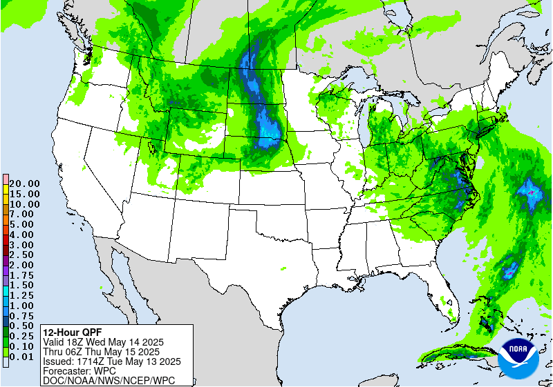
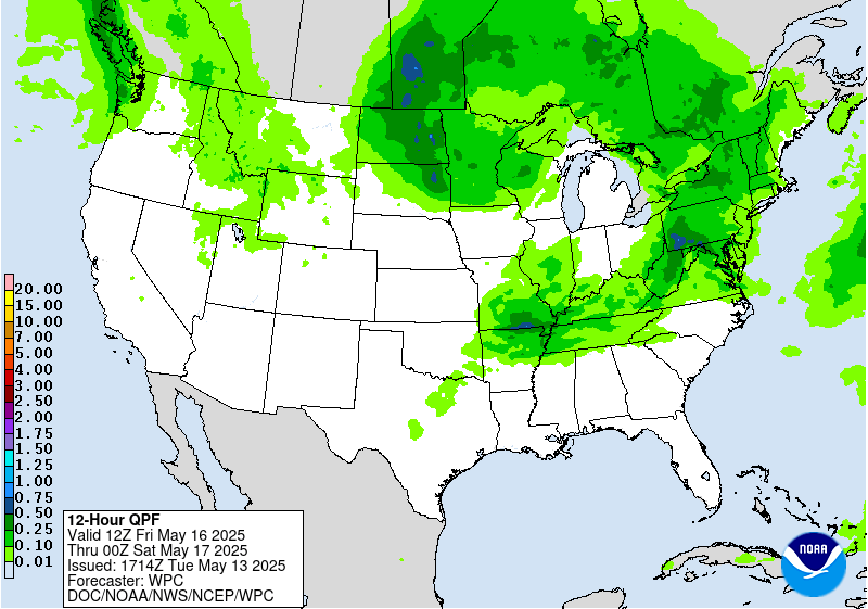
20Z Update: Little updated was necessary for the previous D3 MRGL
inheritance across the Northern Plains and Upper Midwest. There's a
solid QPF magnitude and distribution within the current risk area,
but a majority of the precip will be subject to a strong axis of
deformation with rates capped between 0.75-1.25"/hr during peak
intensity. The heavy rain axis is also subject to the evolution of
the eventual closed upper circulation that will manifest over the
Northern Plains, so positioning is favored over ND, but the
longitudinal placement is spread among the relevant deterministic.
Ensemble mean QPF footprint and ML output are relatively close, but
still slightly off set. In either case, locally enhanced rainfall
from intense dynamics will likely preclude some type of localized
flooding potential despite the lack of true thermodynamic
instability factors. Decided continuity was the best way to go for
the update and will assess in later forecasts for perhaps a
targeted upgrade.
Kleebauer
..Previous Discussion..
An occluded low pressure system will lift northeast across the
Upper Midwest, with showers and storms ahead of the occluded and
cold fronts and some precipitation wrapping around the backside of
the system into the northern Plains as well. Slow storm motion and
repeat activity look like they will be the main threat, which may
result in rain rates that may reach or exceed the 3 hour FFGs.
There will be plenty of moisture in place to support elevated rain
rates with PWAT values reaching 1-1.5 inches. However, instability
may be a limiting factor. The best instability is expected to be
further south along the cold front, displaced from the higher QPF
values. Based on available guidance, a Marginal Risk area should
suffice to account for the low end flash flood potential.
Precipitation is forecast to extend across the Great Lakes region
as well, but rain rates will likely be moderate at best, not
supporting a flash flood threat at this time.
Dolan
Day 3 threat area:
www.wpc.ncep.noaa.gov/qpf/99epoints.txt
Extended Forecast Discussion
NWS Weather Prediction Center College Park MD
235 PM EDT Tue May 13 2025
Showers and thunderstorms increase in coverage and intensity
across the Mid-South and Ohio Valley ahead of a cold front that
will be intercepting deeper return moisture. An broad ERO Marginal
Risk area remains valid for Friday (Day 4) from Arkansas to the
central Appalachians, including portions of the Ohio Valley. Going
into Saturday (Day 5) attention then turns to portions of the
southern Plains and extending to the Mid-South with enhanced
moisture convergence near the same frontal boundary and ahead of a
developing wave of low pressure near the Texas Panhandle. Anomalous
moisture combined with low flash flood guidance values across
parts of the Northeast allowed for the introduction of a marginal
risk area on the Day 5/Saturday ERO for this region ahead of a
departing front and redevelopment of low pressure offshore.
Elsewhere across the nation, the Storm Prediction Center is
monitoring the potential for severe weather from the Midwest to the
Mid-South to close out the work week with favorable instability
and kinematics. Across the Rockies, expect additional chances for
late season snow for the central and northern Rockies by Sunday
into Monday as the next upper trough and shortwave moves in, with
the potential for over a foot of accumulation for some of the
highest mountain ranges. At least locally heavy rainfall seems
likely to develop across the Great Basin over the weekend and into
the north-central U.S. early next week in response to the
developing upper low which will continue to be monitored.
Very warm weather will be commonplace across the eastern half of
the country to close out the work week, with highs well into the
80s and even some lower-middle 90s from the Ohio Valley and Mid-
Atlantic southward to the Gulf Coast. Early season excessive heat
is expected across southern Texas through the upcoming weekend with
highs exceeding 100 degrees near the Rio Grande and into much of
central Texas, and HeatRisk reaching the major to extreme category
for some of these areas, with temperatures in the 70s providing
little to no relief overnight. In contrast, chilly conditions are
likely for the Intermountain West and Northern Rockies/Plains with
highs running 10 to perhaps 20 degrees below average with the upper
level trough and increased cloud cover.
Santorelli/Hamrick


