Excessive Rainfall Discussion
NWS Weather Prediction Center College Park MD
807 PM EDT Tue May 13 2025
Day 1
Valid 01Z Wed May 14 2025 - 12Z Wed May 14 2025
...THERE IS A SLIGHT RISK OF EXCESSIVE RAINFALL OVER PORTIONS OF
THE MID-ATLANTIC AND OHIO VALLEY...
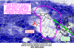
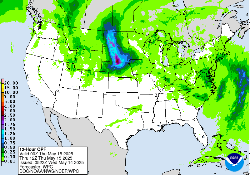
01Z Update: Realigned the outlook areas a bit based on trends in
satellite and radar imagery across portions of West Virginia and
the adjacent portions of the Mid-Atlantic. Maintained the Marginal
risk area over portions of southeast Ohio where convection with
heavy rainfall occurred earlier in the day had started to weaken
with the loss of daytime heating and upstream cloud tops were
warming and decreasing in areal coverage. Even so...there were
enough signals to suggest additional showers could redevelop. Over
the Mid- Atlantic region, confluent flow has been strengthening
the focus for training cells aligning with terrain...and the
approach of an upper level trough been aiding pressure falls over
portions of Virginia. With surface dewpoints in the 65 to 70 degree
range leading to surface based CAPE values on the order of 2000 J
per kg...the environment has been supporting some locally intense
downpours, With loss of solar insolation...the expectation is for
rates to taper off in the 02Z to 04Z range. In addition to the loss
of daytime heating...cells will begin to encounter a more stable
airmass as they head north and should result in a more stratiform
rainfall later.
Bann
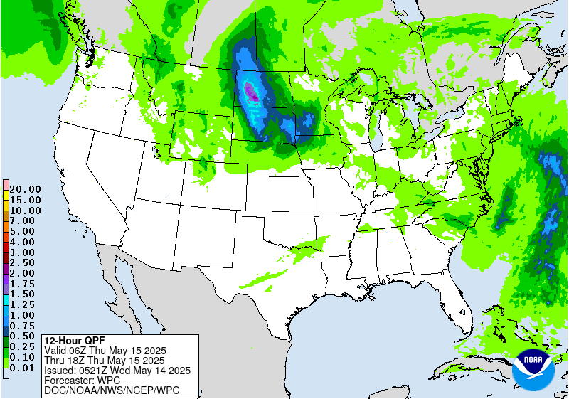
16Z Update: The overall synoptic pattern remains unchanged with the
progression at both the surface and upper levels maintaining run to
run continuity within the hi-res suite. Steady plume of moisture
between 925-500mb will aid in continued moderate to heavy rain
signature across the Mid Atlantic with a stronger convective focus
situated across the Southern Mid Atlantic and Blue Ridge due to
some marginal clearing as dry air advects aloft under the base of
the upper low. Current IVT orientation remains sufficient for
primed easterly upslope across the Central and Northern Blue Ridge
with waves of heavier QPF migrating west-northwest from the Potomac
to points west. Latitudinal push of heavier precip will occur this
evening as the surface low develops across Eastern NC and moves
just offshore towards the VA Capes by the morning. This will align
the moisture advection pattern a bit further north putting areas
from Central and Eastern PA down into the Central Mid Atlantic
urban centers and Delmarva into play for some of the heavier echoes
anticipated with the setup. The jury is still out on whether the
rates will be sufficient for the Balt/DC metro area during the
forecast, but the urbanization factors are a lean towards
maintaining continuity as any significant rainfall cores and
training echoes could cause some flash flood concerns east of US15.
12z HREF neighborhood probs for >3" are very high (>70%) within the
Central Blue Ridge up into the Lower Susquehanna Valley and eastern
slopes of the Laurels. Pockets of elevated probs (>50%) are present
for >5" totals as well within the same corridor with the highest
centered over the Blue Ridge thanks to the textbook easterly
upslope signature within a core of higher IVT in conjunction with a
reasonable theta_E maxima that aligns with the terrain. This has
allowed for a general maintenance of the SLGT risk inherited with
only minor modifications based on QPF output via latest HREF
blended mean and prob fields.
Secondary and tertiary QPF maxima are positioned within the Ohio
Valley and portions of Eastern NC due to the proxy of the ULL and
modest buoyancy under the low center for the OV, and persistent
onshore component over Eastern NC during the first half of the
forecast period. Widespread MRGL risk encompasses the SLGT across
much of the Ohio Valley down into parts of the Southeast as
isolated convection pivots around the ULL with some repeated cell
impacts plausible given the slower mean storm motions under the
primary ULL.
Kleebauer
..Previous Discussion..
A closed upper low will gradually lift north over the Tennessee
and Ohio Valleys, accompanied by a very slow-moving surface low
pressure system. A stream of deep Gulf/Atlantic moisture will move
into the Mid-Atlantic ahead of the system, increasing PWAT values
to 1.5-2 inches. There will be enough instability (MUCAPE > 1500
J/kg) to support thunderstorm development, some of which may be
strong/deep. The best chances for deep convection with high rain
rates (1-2 inches) will likely be over portions of Virginia and
eastern North Carolina where higher instability will reside, but
persistent upslope enhancement will also contribute to elevated
rain rates over portions of the Appalachians from central and
southern Pennsylvania to Virginia. These areas will likely see 1-3
inches of rainfall today, with locally higher amounts in terrain
and heavier convection. Heavy rain will have the potential to
create isolated to scattered flooding concerns across these areas,
warranting a Slight Risk of excessive rainfall.
Elsewhere, a Marginal Risk of excessive rainfall is in effect for
the Ohio Valley and portions of the Tennessee Valley and interior
Southeast where scattered diurnal convection is expected underneath
the upper low. Slow storm motion will contribute to elevated rain
rates (1+ inch per hour) that could reach or exceed 1 and 3 hour
FFGs (1-2 inches). Given that soils in these areas are already
saturated from recent heavy rain, these rain rates could create
isolated instances of flash flooding.
Dolan
Day 1 threat area:
www.wpc.ncep.noaa.gov/qpf/94epoints.txt
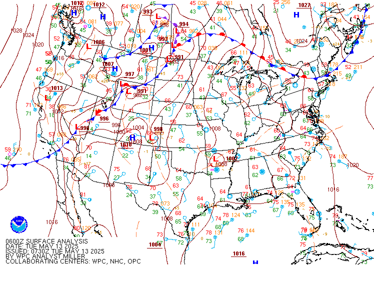
Excessive Rainfall Discussion
NWS Weather Prediction Center College Park MD
333 AM EDT Wed May 14 2025
Day 1
Valid 12Z Wed May 14 2025 - 12Z Thu May 15 2025
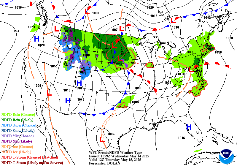
...THERE IS A MARGINAL RISK OF EXCESSIVE RAINFALL FOR PORTIONS OF
THE NORTHERN PLAINS AND MID-ATLANTIC...
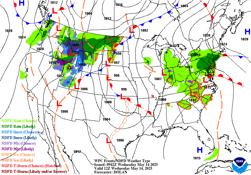
...Northern Plains...
A deep upper level trough centered over the Intermountain West this
morning will become negatively tilted as an impressive shortwave
draws plentiful upper level energy into the northern Plains.
Surface cyclogenesis is expected ahead of this trough over Kansas,
which will track NNE into south-central North Dakota by Thursday
morning. A line of convection associated with the leading/eastern
edge of the trough is moving into far western South Dakota from
Wyoming, and this line of storms will track NNE over the western
Dakotas through the morning. The primary flooding threat will be
from a new line of storms which will develop over western South
Dakota with peak heating this afternoon, then track very slowly
eastward, as embedded cells move north, parallel to the line. This
will result in some training of convection, leading to an isolated
flash flooding threat.
In coordination with UNR/Rapid City, SD; FSD/Sioux Falls, SD; and
ABR/Aberdeen, SD forecast offices, the inherited Slight Risk was
removed with this update, and the surrounding Marginal shifted well
to the west of inherited. The westward shift was due largely to a
shift in the guidance slowing the forward motion of the trough.
While this increased forecast rainfall amounts some, the area of
the Dakotas now highlighted is in Moderate to in some localized
cases Severe drought. Nasa Sport soil moisture imagery shows the
area has next to no moisture. Thus, despite the potential for heavy
rainfall at times in some areas, the flooding threat was determined
to be isolated.
...Mid-Atlantic...
Lingering moisture from a slow moving storm system associated with
a weak upper level negatively tilted trough along with MUCAPE
values in the area between 1,000 and 1,500 J/kg this afternoon will
lead to a renewed round of showers and thunderstorms across much of
the Mid-Atlantic. Due to the movement of the trough however, the
storms should be rather progressive, which will limit the amount of
rainfall any one area sees. While the entire area has picked up 1-2
inches of rain yesterday, thoroughly saturating the near-surface
soils, expect most areas to see less than an inch of new rain.
Those localized areas under the stronger storms may perhaps
approach an inch of new rainfall. This should keep flash flooding
isolated and localized, albeit with some uncertainty. For now the
area remains in a higher end Marginal with few changes from
inherited. 00Z HREF guidance shows a high probability of exceeding
3 and 6 hour FFGs from far western Maryland southeast to the
Tidewater of Virginia with these storms and low FFGs, but it
remains unclear as to the impacts from the resultant flooding given
the significantly lower amounts of rain expected today as compared
with yesterday.
Wegman
Day 1 threat area:
www.wpc.ncep.noaa.gov/qpf/94epoints.txt
Excessive Rainfall Discussion
NWS Weather Prediction Center College Park MD
333 AM EDT Wed May 14 2025
Day 2
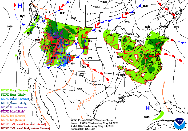
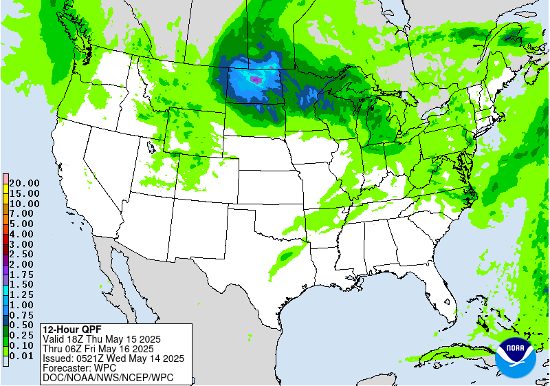
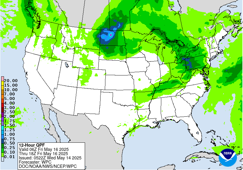
Valid 12Z Thu May 15 2025 - 12Z Fri May 16 2025
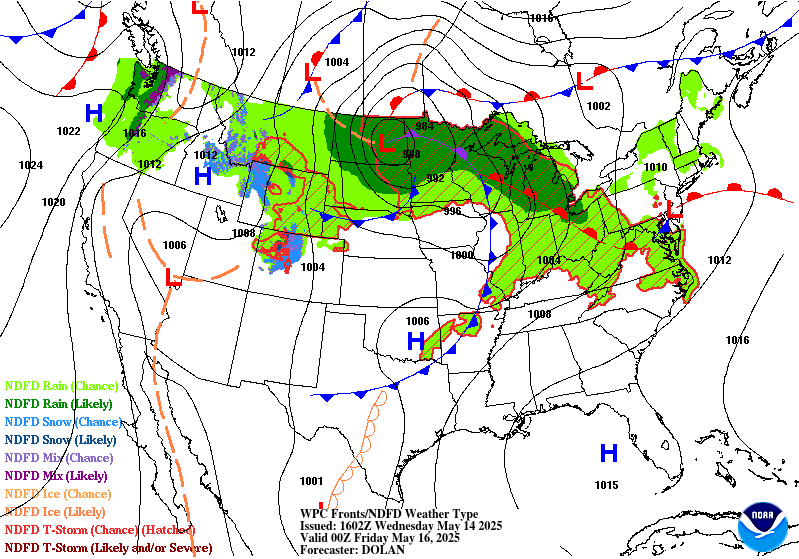
...THERE IS A MARGINAL RISK OF EXCESSIVE RAINFALL FOR PORTIONS OF
THE NORTHERN PLAINS...
The low over the northern Plains will become vertically stacked as
the upper trough catches up with the surface low. With the new
vertically stacked low moving only very slowly towards the
northeast, this will make for a prolonged period of rain on the
cold/northwest side of the center, as it becomes the comma head
region of the low. This area of the low is expected to be largely
devoid of convection given the lack of instability making it quite
that far north and west. Thus, expect the 2-3 inches of additional
rainfall from today to have only a minimal impact given the still
largely dry soils over much of North Dakota. This Marginal was
shifted well to the west following the latest guidance trends, so
the Marginal was removed from much of Minnesota due to lack of
expected rainfall.
Wegman
Day 2 threat area:
www.wpc.ncep.noaa.gov/qpf/98epoints.txt
Excessive Rainfall Discussion
NWS Weather Prediction Center College Park MD
333 AM EDT Wed May 14 2025
Day 3
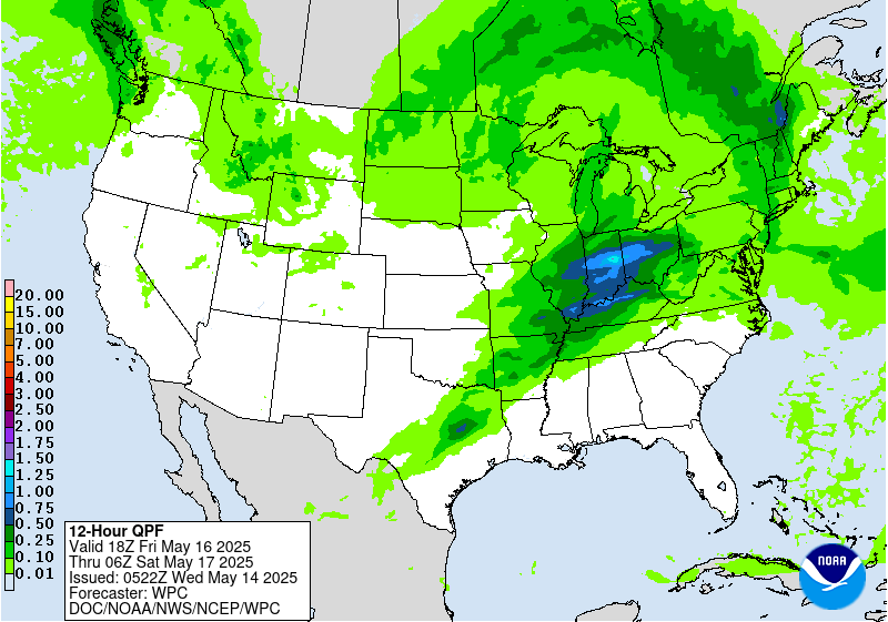
Valid 12Z Fri May 16 2025 - 12Z Sat May 17 2025
...THERE IS A MARGINAL RISK OF EXCESSIVE RAINFALL FOR PORTIONS OF
THE MIDWEST, TENNESSEE VALLEY, AND OZARKS...
A potent shortwave trough will round the periphery of the
vertically stacked low over the northern Plains and upper Great
Lakes on Friday. This shortwave will tap into a low level jet of
Gulf moisture riding the prior low's occluded front. This will
reinvigorate the front, resulting in rather fast northeastward
moving storms across the Marginal Risk area. Much of this area
remains saturated for soil moisture from recent prior storms, so
any training thunderstorms will be capable of producing isolated
flash flooding. There is poor agreement on the character of the
storms, which better agreement may have warranted a Slight Risk
upgrade in part due to the wet soils in this area. For now, will
continue to monitor the trends in the rainfall guidance for better
indication on if a Slight Risk upgrade is needed.
Wegman
Day 3 threat area:
www.wpc.ncep.noaa.gov/qpf/99epoints.txt
Extended Forecast Discussion
NWS Weather Prediction Center College Park MD
259 AM EDT Wed May 14 2025
Showers and thunderstorms increase in coverage and intensity
from the southern Plains and extending to the Mid-South over the
weekend with enhanced moisture convergence near quasi-stationary
frontal boundary and ahead of a developing wave of low pressure
near the Texas Panhandle. The guidance suggests multiple rounds of
convection across the region, but differ on QPF placement, so a
broad Marginal Risk area is valid for portions of this region on
both Saturday and Sunday. Anomalous moisture combined with low
flash flood guidance values across parts of the Northeast allowed
for the continuation of a Marginal Risk area for the Day
4/Saturday ERO for this region ahead of a departing front and
redevelopment of low pressure offshore, and moisture lingers across
eastern Maine where a Marginal Risk is planned for Sunday.
Across the Rockies, expect additional chances for late season snow
for the central and northern Rockies by Sunday into early next
week
as the next upper trough and shortwave moves in, with the potential
for over a foot of accumulation for some of the highest mountain
ranges. Widespread moderate to locally heavy rainfall seems likely
to develop across the Great Basin over the weekend and into the
north-central U.S. early next week in response to the developing
upper low which will continue to be monitored. A Marginal Risk area
is planned for Sunday/Day 5 across portions of eastern Nevada,
southwest Utah, and northern Arizona where slow moving convection
associated with the upper low may result in some localized flooding
across the high desert. Another area of enhanced rainfall is
looking more likely across the northwestern High Plains on Sunday
as well with increased moisture flux to the north of the developing
surface low ejecting east from the Rockies, and a Marginal Risk
area is also planned for this area on Sunday.
Early season excessive heat is expected across central and southern
Texas through the upcoming weekend with highs exceeding 100
degrees near the Rio Grande and into much of central Texas, and
HeatRisk reaching the major to extreme category for some of these
areas. This will likely set additional record high temperatures for
these areas, and overnight lows will struggle to fall below 75
degrees for many of these same areas. In contrast, chilly
conditions are likely for the Intermountain West and Northern
Rockies/Plains with highs running 10 to perhaps 20 degrees below
average for many areas from Arizona to Idaho with the upper level
trough and increased cloud cover.
Hamrick


