Excessive Rainfall Discussion
NWS Weather Prediction Center College Park MD
855 PM EDT Mon Jul 20 2026
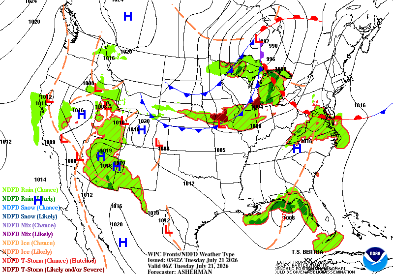
Day 1
Valid 01Z Tue Jul 21 2026 - 12Z Tue Jul 21 2026
...THERE ARE SLIGHT RISKS OF EXCESSIVE RAINFALL FOR PORTIONS OF THE
SOUTHWEST AND NORTH CAROLINA...
...Southwest...
01Z Update...little change needed as monsoon moisture continues to
stream across the Southwest into the Great Basin with renewed
diurnal convective coverage. Elevated moisture with PW of 2 to 2.5
standard deviations above normal and limited cloud cover earlier
today allowed for good coverage of convection. Focus of heavies
along the Mogollon Rim, southeast Arizona and southern New Mexico.
...Southern Mid-Atlantic to southern Appalachians...
A warm front on leaving edge of deep tropical moisture plume
extending northeastward from Tropical Storm Bertha in the Gulf.
The front will continue to provide enough forcing across much of
eastern North Carolina to allow for convection to persist into the
late evening/early morning hours. Soils have moistened somewhat but
should still be able to handle additional rainfall without too many
problems. Above normal moisture for the storms to work and the
front providing some forcing warrants continuation of the Slight
Risk.
...Gulf Coast...
The outermost periphery of circulation around Tropical Storm
Bertha continued to impact the Gulf Coast of Florida, through the
Panhandle into southern Georgia, and over to southeastern
Louisiana this evening. Banding is occurring, so there are
localized instances of multiple inch per hour rainfall rates.
Regardless, the center remains far enough offshore, with satellite
imagery from this evening still showing drier air aloft working to
significantly cut down on the overall coverage of storms.
Considering the dry soils and high FFGs typical of the immediate
Gulf Coast, even periods of heavy rain should only result in
isolated instances of flash flooding. Thus, there was little change
to the Marginal Risk area.
...Midwest...
The Marginal Risk across much of the Midwest and upper Great Lakes
also remains largely intact with the outlook area updated based on
trends of late afternoon/early evening satellite imagery. progression
It appears the most likely areas to be impacted tonight are from
central Iowa east across northern Illinois. Dry soils highlight
this area, so this being the height of the growing season should
mitigate the flash flood risk.
Jackson/Bann
Day 1 threat area:
www.wpc.ncep.noaa.gov/qpf/94epoints.txt
Excessive Rainfall Discussion
NWS Weather Prediction Center College Park MD
855 PM EDT Mon Jul 20 2026
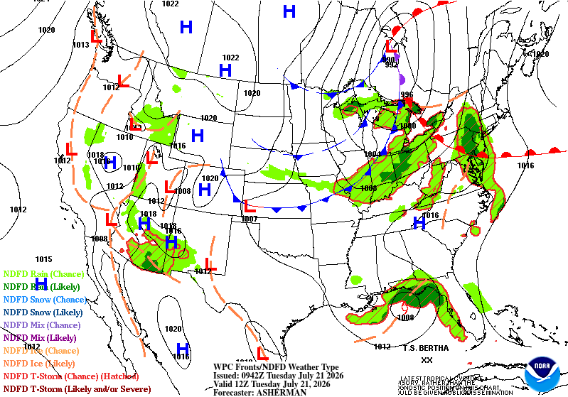
Day 2
Valid 12Z Tue Jul 21 2026 - 12Z Wed Jul 22 2026
...THERE ARE SLIGHT RISKS OF EXCESSIVE RAINFALL ACROSS PORTIONS OF
THE SOUTHWEST AND THE MID-ATLANTIC TO THE OHIO VALLEY...
...Intermountain West...
Monsoonal moisture continues to arrive over the Southwest from the
sub-tropical Pacific around a mid-level high centered over
Colorado. A shortwave trough will track from southwest NM into
eastern AZ which will promote increased convective coverage over
both AZ and UT into NV. The Slight Risk area was further expanded
to include most of UT through central NV. The greatest convective
coverage and most impactful flash flooding is still expected from
southeast AZ up through the Mogollon Rim to the Grand Canyon which
is considered a more "enhanced" Slight Risk. A fair amount of
convective coverage tonight over AZ may cause some opaque stratus
to persist into Tuesday which could at least locally disrupt the
diurnal trend in activity.
The PW anomaly reaches 4 standard deviations above normal over the
Sierra Nevada on Tuesday. This should promote vigorous diurnal
convection up the High Sierra to Lake Tahoe. A Slight Risk may be
warranted, but for now an expanded Marginal Risk is drawn.
...Mid-South through the Ohio Valley and Mid-Atlantic into New
England...
A strong cold front pushing south across the Midwest will run into
plentiful tropical moisture being drawn north from Tropical
Depression 2 in the Gulf. The front will act as a catalyst for
numerous segments of mostly fast moving thunderstorms across the
Ohio Valley and Interior Northeast through the Mid-Atlantic on
Tuesday, likely holding together for the into New England Tuesday
evening. PW of 2 to 2.25" ahead of the front and sufficient
instability will allow for heavy rainfall through this area,
possibly as far west as the Mid-South (per the RRFS and the 12Z
HRRR) and as far east as the New England coast up through Down East
Maine. Mean layer Wly to SWly flow of 40-50kt will keep activity
moving, but the threat for backbuilding and training storms as well
as the book ends of any segments could cause widely scattered
instances of flash flooding. The Slight Risk was expanded per 12Z
(and 18Z HRRR) CAM consensus along with chats with WFO PHI/OKX
through the northern Mid-Atlantic into Connecticut.
...Gulf Coast...
Tropical Depression 2 is still forecast to gradually drift west
with the center offshore until reaching southern Louisiana early
Thursday. Northerly shear and dry air entrainment will continue to
focus most associated precip south of the center with the banding
seen today east and north of the track over FL diminishing tonight
and having less coverage for Tuesday. This is in spite of this
being a tropical cyclone with PWATs up to 2.5 inches. Therefore,
the Marginal Risk for the Florida Panhandle through southeast
Louisiana remains in place with few changes.
Jackson/Wegman
Day 2 threat area:
www.wpc.ncep.noaa.gov/qpf/98epoints.txt
Excessive Rainfall Discussion
NWS Weather Prediction Center College Park MD
855 PM EDT Mon Jul 20 2026
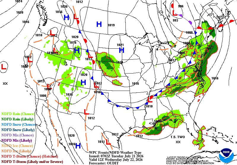
Day 3
Valid 12Z Wed Jul 22 2026 - 12Z Thu Jul 23 2026
...THERE ARE SLIGHT RISKS OF EXCESSIVE RAINFALL FOR THE SOUTHERN
MID-ATLANTIC TO THE SOUTHERN APPALACHIANS, MUCH OF THE CENTRAL
ROCKIES, AND LOWER SOUTHEAST LOUISIANA...
...Mid-Atlantic to Tennessee Valley...
The cold front that reaches much of the Mid-Atlantic on Tuesday
will stall over the Delmarva through southern Virginia and the
southern Appalachians on Wednesday. Abundant Gulf moisture will
continue streaming northeastward from Tropical Depression 2 ahead
of the front with PW spiking above 2.25". Westerly mean layer flow
becomes parallel to this front on Wednesday which will promote
training activity and repeating heavy thunderstorms. This places
the focus farther north than the prior forecast with areas from the
Delmarva through North Carolina at risk where the Slight Risk was
redrawn. There remains a more "enhanced" Slight Risk over southeast
VA (including Hampton Roads) down toward Raleigh. The Slight Risk
was trimmed on the south end including over southern NC and most of
SC.
Since much of this area should get a break in heavy rain on Day 2,
a Moderate Risk was not considered at this time. However, this
stalled front will only slowly move south Wednesday to Friday which
may open the door to a Moderate Risk at some point over the
southern Mid-Atlantic/Carolinas.
...Central Gulf Coast...
Tropical Depression 2 is forecast to be drifting west toward the
mouth of the Mississippi on Wednesday. Northerly shear will
remain a concern to development of precip on the north side,
keeping most of the heaviest rains over the Gulf. The 12Z consensus
for heavy rain is even farther south than the previous forecast,
well south of New Orleans in an area that is not flash flood prone.
Out of an abundance of caution (a wise approach with tropical
systems) and in coordination with WFO LIX, the Slight Risk remains
in effect for lower southeast Louisiana. Some banding east and
north of the low center looks to track into the central Gulf Coast
where the Marginal Risk was expanded a bit.
...Intermountain West onto the Central Plains...
The shortwave trough tracking north from AZ on Wednesday should
focus the heaviest rain ahead of it over UT/CO up through WY and
eastern ID. The Slight Risk was expanded over these areas based on
the 12Z QPF consensus and in coordination with WFO BOU. Much of the
Rockies terrain is covered by a Slight Risk.
High pressure centered over MN brings some return flow across
Nebraska which warrants continuing the Marginal Risk there with an
expansion into northeast KS per the 12Z consensus.
The PW anomaly drops below 3 standard deviations for the Sierra
Nevada, but enough moisture remains to warrant another Marginal
Risk.
Jackson
Day 3 threat area:
www.wpc.ncep.noaa.gov/qpf/99epoints.txt
Excessive Rainfall Discussion
NWS Weather Prediction Center College Park MD
855 PM EDT Mon Jul 20 2026
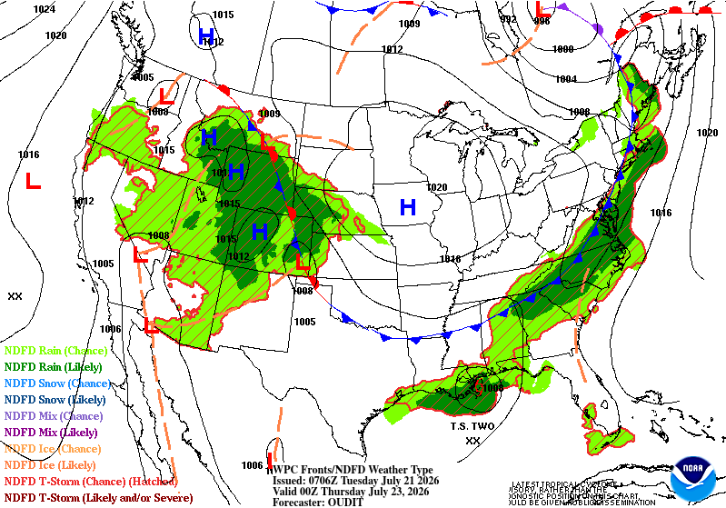
Day 4 and Day 5
Valid 12Z Thu Jul 23 2026 - 12Z Sat Jul 25 2026
...THERE IS A SLIGHT RISK OF EXCESSIVE RAINFALL FOR PORTIONS OF THE
CENTRAL PLAINS TO LOWER MISSOURI VALLEY, THE CENTRAL TO WESTERN
GULF COAST, AND THE EASTERN CAROLINAS ON DAY 4...
...THERE IS A SLIGHT RISK OF EXCESSIVE RAINFALL FOR PORTIONS OF THE
LOWER MISSOURI AND MID MISSISSIPPI VALLEYS, AND THE EASTERN
CAROLINAS ON DAY 5...
2030Z Update...
Removed the Slight Risk area from the Texas portion of the Day 4
Excessive Rainfall Outlook based on the forecast soundings along
and near the path of the system making its way along the Gulf coast
in the shorter periods. Based on NHC guidance available on Monday
afternoon...the system should have transitioned to an extra-
tropical system by then which would facilitate the advection of
unsaturated/drier air from the land.
Elsewhere changes tended to be pretty modest and still largely fit
the previous discussion.
Bann
Previous Discussion...
...Southeast...
A moisture-laden front will continue to sink slowly south across
the region. While the overnight guidance continues to present
differences on the timing of the front and corresponding
precipitation, there remains a strong signal for additional heavy
amounts impacting parts of the region, especially for portions of
the Carolinas. Precipitable Water values remaining around 2.25
inches along with periods of enhanced ascent will raise the threat
for additional heavy amounts most likely centered over eastern
North Carolina into northeast South Carolina Thursday into early
Friday. Due in part to model differences and forecast uncertainty,
maintained a Slight Risk. However, this has the potential to be a
second day in-a-row, and the fourth day this week for heavy rains
impacting parts of the region. Therefore, if forecast confidence
increases and the signal for a multi-day heavy rainfall event
holds, future upgrades may be required.
For Friday into early Saturday, it remains a question
whether the front will continue to push south, bringing drier
conditions into the Carolinas as the GFS/UKMET indicate, or
continue to hang up well to the north as shown by the ECMWF and
Canadian. Opted for a Slight Risk on for the Day 5, centered
similar to the Day 4 area, which presents a compromise between the
two camps and lined up with the higher probabilities from the most
recent ECENS.
...Gulf Coast...
Shear across Tropical Depression Two is expected to keep the
heaviest rainfall amounts associated with the system mostly south
of the center and offshore. However, cannot rule out the threat for
onshore flow supporting some locally heavy amounts along the coast,
especially if the trends support a stronger system and more
northerly track. Therefore, the a Slight Risk was maintained along
the Louisiana to the upper Texas Coast on Day 4.
A Marginal Risk was drawn for Day 5 from the upper Texas Coast
inland toward south-central Texas, where heavy amounts are
possible if the storm remains organized and continues to track
west.
...Central Plains to the Mid Mississippi Valley...
Models continue to show a well-defined shortwave sliding southeast
off of the top of the western U.S. ridge through the northern
Plains and into the mid Mississippi Valley on Day 4. Organized
heavy rain may develop late Thursday into early Friday as this
energy interacts with a deepening moisture pool fed by a
strengthening southwesterly jet. A Slight Risk was maintained on
Day 4 over parts of southeastern Nebraska into adjacent parts of
Kansas, Iowa, and Missouri, where models indicate the deepest
moisture, better forcing and greater potential for localized
training will center. Storms continuing through Friday morning and
possibly redeveloping later in the day downstream will extend the
threat across across a greater part of the mid Mississippi Valley
on Day 5.
...Southwest/Great Basin/Central and Southern Rockies...
Monsoon moisture will continue to fuel diurnal activity, however
the footprint is expected to diminish especially by Day 5 as
moisture anomalies drop off and heights build across the Southwest.
Pereira
Excessive Rainfall Discussion
NWS Weather Prediction Center College Park MD
855 PM EDT Mon Jul 20 2026
Day 4 and Day 5
Valid 12Z Thu Jul 23 2026 - 12Z Sat Jul 25 2026
...THERE IS A SLIGHT RISK OF EXCESSIVE RAINFALL FOR PORTIONS OF THE
CENTRAL PLAINS TO LOWER MISSOURI VALLEY, THE CENTRAL TO WESTERN
GULF COAST, AND THE EASTERN CAROLINAS ON DAY 4...
...THERE IS A SLIGHT RISK OF EXCESSIVE RAINFALL FOR PORTIONS OF THE
LOWER MISSOURI AND MID MISSISSIPPI VALLEYS, AND THE EASTERN
CAROLINAS ON DAY 5...
2030Z Update...
Removed the Slight Risk area from the Texas portion of the Day 4
Excessive Rainfall Outlook based on the forecast soundings along
and near the path of the system making its way along the Gulf coast
in the shorter periods. Based on NHC guidance available on Monday
afternoon...the system should have transitioned to an extra-
tropical system by then which would facilitate the advection of
unsaturated/drier air from the land.
Elsewhere changes tended to be pretty modest and still largely fit
the previous discussion.
Bann
Previous Discussion...
...Southeast...
A moisture-laden front will continue to sink slowly south across
the region. While the overnight guidance continues to present
differences on the timing of the front and corresponding
precipitation, there remains a strong signal for additional heavy
amounts impacting parts of the region, especially for portions of
the Carolinas. Precipitable Water values remaining around 2.25
inches along with periods of enhanced ascent will raise the threat
for additional heavy amounts most likely centered over eastern
North Carolina into northeast South Carolina Thursday into early
Friday. Due in part to model differences and forecast uncertainty,
maintained a Slight Risk. However, this has the potential to be a
second day in-a-row, and the fourth day this week for heavy rains
impacting parts of the region. Therefore, if forecast confidence
increases and the signal for a multi-day heavy rainfall event
holds, future upgrades may be required.
For Friday into early Saturday, it remains a question
whether the front will continue to push south, bringing drier
conditions into the Carolinas as the GFS/UKMET indicate, or
continue to hang up well to the north as shown by the ECMWF and
Canadian. Opted for a Slight Risk on for the Day 5, centered
similar to the Day 4 area, which presents a compromise between the
two camps and lined up with the higher probabilities from the most
recent ECENS.
...Gulf Coast...
Shear across Tropical Depression Two is expected to keep the
heaviest rainfall amounts associated with the system mostly south
of the center and offshore. However, cannot rule out the threat for
onshore flow supporting some locally heavy amounts along the coast,
especially if the trends support a stronger system and more
northerly track. Therefore, the a Slight Risk was maintained along
the Louisiana to the upper Texas Coast on Day 4.
A Marginal Risk was drawn for Day 5 from the upper Texas Coast
inland toward south-central Texas, where heavy amounts are
possible if the storm remains organized and continues to track
west.
...Central Plains to the Mid Mississippi Valley...
Models continue to show a well-defined shortwave sliding southeast
off of the top of the western U.S. ridge through the northern
Plains and into the mid Mississippi Valley on Day 4. Organized
heavy rain may develop late Thursday into early Friday as this
energy interacts with a deepening moisture pool fed by a
strengthening southwesterly jet. A Slight Risk was maintained on
Day 4 over parts of southeastern Nebraska into adjacent parts of
Kansas, Iowa, and Missouri, where models indicate the deepest
moisture, better forcing and greater potential for localized
training will center. Storms continuing through Friday morning and
possibly redeveloping later in the day downstream will extend the
threat across across a greater part of the mid Mississippi Valley
on Day 5.
...Southwest/Great Basin/Central and Southern Rockies...
Monsoon moisture will continue to fuel diurnal activity, however
the footprint is expected to diminish especially by Day 5 as
moisture anomalies drop off and heights build across the Southwest.
Pereira


