Excessive Rainfall Discussion
NWS Weather Prediction Center College Park MD
447 AM EDT Tue Jul 21 2026
Day 1
Valid 12Z Tue Jul 21 2026 - 12Z Wed Jul 22 2026
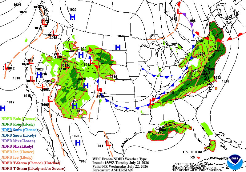
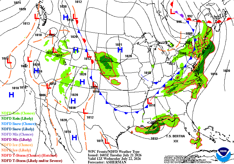
...THERE ARE SLIGHT RISKS OF EXCESSIVE RAINFALL FOR PORTIONS OF THE
SOUTHWEST AND GREAT BASIN AS WELL AS FOR PORTIONS OF THE OHIO AND
TENNESSEE VALLEYS AND INTO THE NORTHEAST...
...Southwest and Great Basin...
The combination of anomalous monsoonal moisture streaming northward
out of the tropical Pacific and a retrograding upper level
shortwave will create a very active day for thunderstorm activity
this afternoon across much of the Pacific Northwest. Moisture
amounts will be anywhere from 2-4 sigma above normal, with PWATs
above 1.5 inches in southern Arizona, and above 1 inch across much
of the rest of the Southwest. The upper level disturbance tracking
west out of New Mexico will force numerous thunderstorms to form
across Arizona. The storms will slowly track westward. Greater
concentrations of storms are expected along the Mogollon Rim where
topography will help allow the storms to congeal along the Rim. Due
to the above normal amounts of moisture, the storms will be capable
of heavy rainfall with the strongest cores possibly producing
rainfall rates to 2 inches per hour. Given the very favorable
hydrology of the Desert Southwest for flash flooding, given
generally very hydrophobic soils and bare rocks, the Slight Risk
remains in place across much of Arizona, with a higher-end Slight
stretching from the southeast corner of the state northwestward
along the Rim to the Grand Canyon. As usual, slot canyons, dry
washes, and other low-lying areas will be more susceptible to
impactful flash flooding downstream of the heaviest rains.
Further north across the Great Basin, the area will be on the
western periphery of the large ridge over Colorado and a nearly
stationary longwave trough off the coast of northern California. A
separate shortwave trough will track across Nevada and into Idaho
this afternoon. Given similarly anomalous amounts of atmospheric
moisture in place as well across this largely flash-flood prone
area from the Sierras east through Utah, clusters of storms will
form in this area associated with the upper level shortwave.
The inherited Slight was expanded west to include the Sierras,
where upslope will greatly contribute to afternoon and evening
thunderstorm activity there, while the steep slopes will support
fast-forming flash flooding downstream of any heavy rain producing
thunderstorms. Elsewhere, few changes were needed, as many of the
areas in the Slight that will be impacted by storms again today
were impacted on previous days, worsening the flash flooding risk.
...Ohio and Tennessee Valleys into the Northeast...
Much of the flooding risk across the eastern half of the country
today will be in association with a strong cold front at the
leading edge of a strong longwave trough over the Great Lakes
pushing south and east across the Ohio and Tennessee Valleys as
well as into the Northeast. Anomalous moisture originating in part
from T.S. Bertha in the Gulf will ride northeastward ahead of the
front, providing plentiful moisture for numerous thunderstorms to
form, some of which will produce multiple-inch-per-hour rainfall
rates. A few areas within the broader Slight Risk are likely to
see more rainfall. In central Kentucky and central Tennessee, a
southwest-to-northeast oriented band of storms is expected to form
on the leading edge of the cold front, with mesoscale "slow-downs"
in the front's progression allowing for a second round of activity
possibly forming over these same areas where FFGs are depressed
from heavy rainfall in recent days.
The greatest rainfall totals are expected to be across portions of
southeastern Virginia, generally from the Richmond metro east
across the Bay and impacting the lower Maryland and Virginia
sections of the Delmarva. Here, a plume of greater moisture will
interact with the front which will be slowed by its passage across
the mountains. An early to mid afternoon round of storms with the
initial approach of the upper level trough and associated shortwave
energy will move across southern Virginia first. Much more numerous
storms will impact the area in the evening hours as the main front
approaches the area. Despite the loss of daytime heating, the front
is expected to stall over southern Virginia, which could very well
allow for a prolonged period of training storms to set up in the
aforementioned area, which will persist through the overnight. A
short-fused Moderate Risk cannot be ruled out should this evolution
play out as expected by several of the CAMs.
Finally, across the area form northern New Jersey northeast into
the Hudson Valley, morning thunderstorms caught along the Catskills
and Poconos associated with a warm front may start out the day with
a period of training thunderstorms as moisture and instability
levels increase south of the front. This will likely be the feature
that causes the most rainfall in the area. Once the fast-moving
cold front sweeps eastward across the area, resulting in a much
shorter period of widespread thunderstorm activity, its passage
will end the threat for heavy rain in this area for the night.
...Gulf Coast/Tropical Storm Bertha...
As has been the case for several days, the convective pattern with
Bertha in the guidance is little changed. Northeasterly shear will
continue to keep any persistent heavy rainfall well south of the
Gulf Coast for the next several days. Only small and isolated bands
of rain trying to wrap around the center will impact the coast.
The inherited Marginal Risk remains little changed from Louisiana
through the Florida Panhandle.
Wegman
Day 1 threat area:
www.wpc.ncep.noaa.gov/qpf/94epoints.txt
Excessive Rainfall Discussion
NWS Weather Prediction Center College Park MD
447 AM EDT Tue Jul 21 2026
Day 2
Valid 12Z Wed Jul 22 2026 - 12Z Thu Jul 23 2026
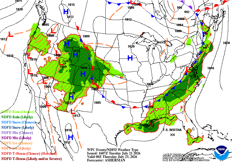
...THERE ARE SLIGHT RISKS FOR EXCESSIVE RAINFALL OVER PORTIONS OF
THE INTERMOUNTAIN WEST AS WELL AS FROM NORTHERN GEORGIA THROUGH THE
TIDEWATER OF VIRGINIA AND NORTH CAROLINA...
...Intermountain West...
Highly anomalous amounts of atmospheric moisture associated with
the monsoon over the Intermountain West will be activated by rapid
height falls as an upper level and highly negatively tilted trough
pushes east from off the coast of Washington and Oregon. Meanwhile,
separate upper level energy undercutting the ridge will also
provide additional forcing further east across eastern Idaho and
Wyoming. Once again, numerous thunderstorms will form in the
anomalous moisture and for many areas, will be tied to the local
topography. Few changes were needed with this update. The greatest
amounts of rain look to concentrate in western Wyoming, where any
storms south of Yellowstone could necessitate a higher-end Slight
for some of those areas, as well as for the Uintas of northern
Utah. With nearly all of the forcing further north, the Marginal
Risk into southern Arizona and southern New Mexico was trimmed
significantly with this update, as ridging quickly overtakes this
area and limits convective potential south/west of the Mogollon Rim
as a result.
...Carolinas, Southern Virginia, and Northern Georgia...
A strong cold front running into highly anomalous moisture being
siphoned from the circulation of Tropical Storm Bertha will
exacerbate the gradient of moisture along the frontal interface
through the day across the Carolinas and into southeastern
Virginia. This will work to keep any forward progress of the front
minimal. Storms will train along the front, especially across
northeastern North Carolina and into southeastern Virginia. This
area remains in a higher-end Slight Risk and with the stalled out
front remaining to guide the frequent development of additional
storms, a Moderate Risk upgrade in areas where the storms focused
in the Day 1 period remains a distinct possibility. Guidance has
been laser focused in this area and so forecast changes have been
minimal. Further south and west, however, guidance has become
increasingly optimistic on storms developing further west into the
southern Appalachians. As such, the Slight Risk was expanded west
to include this region from north of Atlanta through the western
Carolinas.
...Tropical Storm Bertha/Gulf Coast...
Strengthening shear across the circulation will continue to keep
any organized convection and meaningful rainfall out over the open
waters of the Gulf. The immediate coastline could still see amounts
greater than an inch, but the rainfall footprint continues to shift
off the coast. In coordination with LIX/Slidell, LA forecast
office, the inherited Slight Risk for this region was downgraded
with this update, with the overall area of the surrounding Marginal
remaining little changed. What little rainfall does impact land
areas remains with the potential to be locally heavy, so
unfortunately no changes to the Marginal Risks can be made so long
as Bertha remains a tropical entity.
Wegman
Day 2 threat area:
www.wpc.ncep.noaa.gov/qpf/98epoints.txt
Excessive Rainfall Discussion
NWS Weather Prediction Center College Park MD
447 AM EDT Tue Jul 21 2026
Day 3
Valid 12Z Thu Jul 23 2026 - 12Z Fri Jul 24 2026
...THERE ARE SLIGHT RISKS FOR EXCESSIVE RAINFALL FOR A PORTION OF
THE SOUTHEAST FROM GEORGIA THROUGH THE CAROLINAS AS WELL AS FOR
NORTHEAST KANSAS AND SOUTHEAST NEBRASKA...
...Southeast...
The stalled out front that has remained across the Southeast will
continue to plague the area with very heavy rainfall, as the
continuous stream of Gulf moisture from the Gulf funnels
northeastward along the front. Yet another day of heavy rain is
expected to impact the Carolinas as a result. The front may drift
ever so slightly further south and east which should clear all but
the Hampton Roads area of far southeast Virginia from the heavy
rainfall threat by Thursday, but for much of eastern North
Carolina, much of South Carolina, and portions of northern Georgia,
generally from Atlanta east, the heavy rainfall threat will
continue through Thursday. Once again, potential for very heavy
rainfall totals in many areas as are expected to see heavy rain
from Wednesday could mean further upgrades to the risks may be
needed, especially across eastern North Carolina. Ultimately, where
the heaviest rain falls both today and Wednesday should dictate if
further upgrades will be needed.
...Central Plains...
An MCS is expected to impact a portion of northeast Kansas,
southeast Nebraska and the Kansas City and St. Joseph metros on
Thursday. The heavy rainfall footprint has drifted south and west,
so the Slight Risk has been adjusted accordingly. As with many
MCS's the location of the heaviest rain is likely to continue
shifting with future updates, most likely towards the south, so
stay tuned for further updates. Periods of heavy rain may continue
to impact Wyoming into Colorado as well, where upgrades to a Slight
are also probable, depending on where the heavy rains from
Wednesday overlap with Thursday's forecast.
...Bertha...
Bertha, who may no longer be a tropical cyclone by Thursday, and
likely to be in a weakening state, should continue to keep any
associated rainfall off the coast. The immediate coast remains with
the best chance for seeing anything over an inch of associated
rainfall. FFGs are significantly higher than that in all areas.
Given this, and with very good consistency in this scenario in the
guidance, the inherited Slight and Marginal for a portion of the
Texas and Louisiana Gulf coasts was removed with this update. The
Marginal Risk has been downgraded to under a 5% risk for the upper
Texas Gulf Coast, as well as the Slight for coastal Louisiana
downgraded to a Marginal with this update.
Wegman
Day 3 threat area:
www.wpc.ncep.noaa.gov/qpf/99epoints.txt
Excessive Rainfall Discussion
NWS Weather Prediction Center College Park MD
447 AM EDT Tue Jul 21 2026
Day 4 and Day 5
Valid 12Z Fri Jul 24 2026 - 12Z Sun Jul 26 2026
...THERE IS A SLIGHT RISK OF EXCESSIVE RAINFALL FOR PORTIONS OF THE
LOWER MISSOURI VALLEY AND MID MISSISSIPPI VALLEYS ON DAY 4 AND FOR
PARTS OF SOUTHEAST COAST DAYS 4 AND 5...
...Southeast...
A multi-day rainfall event is expected to continue into the
weekend, with additional heavy rains likely, especially for parts
of southeastern Virginia and the Carolinas. The focus for these
rains will be a slow-moving, moisture-laden front that is forecast
to linger across the region through at least the first half of the
weekend. Southwesterly flow ahead of a shortwave trough moving
through the Ohio/Tennessee valleys will further fortify the already
moisture-rich airmass, with models showing PWs increasing in
excess of 2.25 inches (+2 to 3 sigma). This moisture, along with
pockets of enhanced ascent afforded by mid-level energy, will
support periods of heavy, highly-efficient rainfall. While areas of
heavy rainfall are likely, forecast confidence regarding their
placement remains limited due to continuing model spread with
regards to the placement of the front, which will have impacts on
where the heaviest amounts occur.
...Gulf Coast...
Northeasterly shear and dry air north of the center should keep
much of the heavy rainfall threat associated with T.S. Bertha out
over the open waters. Also, there is some question regarding the
intensity of the system and if it will retain a closed circulation
as it moves from the Louisiana onto the upper Texas coasts early in
the period. However, cannot not rule out an isolated threat for
heavy rainfall and therefore maintained a Marginal Risk for now
from the southwestern Louisiana to the upper Texas coasts on Day 4.
...Lower Missouri-Mid Mississippi to the Tennessee Valleys/Southern
Appalachians...
Ongoing storms associated with pooling moisture along a low-level
boundary and ahead a mid-level shortwave dropping southeast may
continue to support storms and the threat for heavy rains Friday
morning (Day 4) across parts of the lower Missouri Valley. Storms
are expected to wane by late in the morning, but there remains a
model signal for new storms developing farther to the south and
east as additional energy interacts with deepening moisture (PWs
increasing to 2-2.25 inches) that will be supported by
southwesterly low level inflow.
As this energy spills farther south, it may help to organize heavy
rainfall across portions of the Tennessee Valley into the southern
Appalachians, where a Marginal Risk was introduced for Day 5.
Forecast confidence was limited by model spread, however this may
be an area where a targeted upgrade is required in a future update
if confidence increases.
...Southwest/Great Basin/Central and Southern Rockies...
After what is expected to be a downward trend in convective
coverage and potential flash flooding late in the week (Day 4),
moisture anomalies are forecast to increase again on Saturday. This
increasing moisture along with mid level energy moving around the
southwestern periphery of a broad high will help expand afternoon
and evening storm coverage, including the southern Arizona deserts.
Pereira


