Excessive Rainfall Discussion
NWS Weather Prediction Center College Park MD
1152 AM EDT Thu May 15 2025
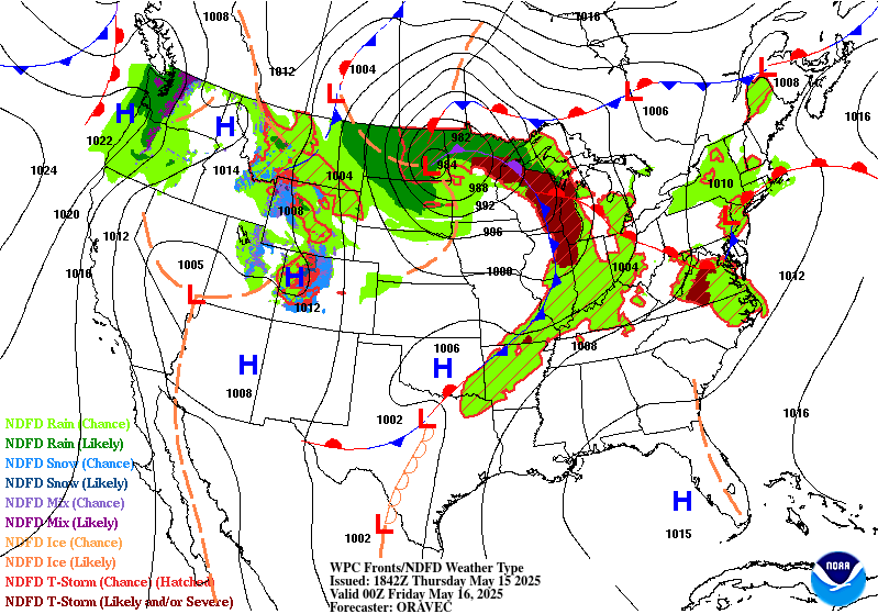
Day 1
Valid 16Z Thu May 15 2025 - 12Z Fri May 16 2025
...THERE IS A MARGINAL RISK OF EXCESSIVE RAINFALL FOR PORTIONS OF
THE NORTHERN PLAINS, CENTRAL MIDWEST, OHIO VALLEY AND MID-
ATLANTIC...
...Northern Plains...
16Z Update: The previous forecast remains on track with the lack of
sufficient instability likely to keep much of the Dakotas within a
broad moderate stratiform precip shield leading to lower
probability of flash flooding despite forecast totals. A tongue of
higher theta_E within the eastern flank of the low will allow for a
strong cell or two to pivot up from Eastern SD into Southeast ND
with a small sector potentially having the "best" threat for flash
flood prospects. This will be the area of interest the next 6-12
hrs before conditions settle to majority stratiform, likely leading
to an end of any risk for the back half of the forecast.
Kleebauer
..Previous Discussion..
A well-developed low will track north into the eastern Dakotas into
this afternoon, with a slow and chaotic track through tonight. This
track is supported by a nearly stationary upper level low, with a
potent shortwave trough rounding its southern periphery, thus
increasing the divergence aloft. While the low itself will be able
to tap into some of the Gulf moisture across much of the eastern
half of the country, this is not expected to result in significant
flash flooding. For North Dakota, any associated instability is
likely to stay east of the low center. Meanwhile, the cold conveyor
belt feeding the comma-head region of the surface low will be
unable to also advect instability into the region. Thus, while the
24 hour rain forecast remains consistent with continuity with a
forecast for 2-3 inches of rain across Western North Dakota
through 12Z Friday, the lack of instability will keep that rainfall
as stratiform, and therefore unlikely to cause flash flooding.
...Mid-Atlantic...
16Z Update: Scattered convective development through the afternoon
and evening will generate some low-end flash flood concerns within
the region. The areas of interest are likely the more sensitive
App/Blue Ridge areas where FFG's are incredible low (<0.5"/hr)
where any convection could cause problems within a remnant, moist
airmass, as well as the corridor between Philadelphia to Newark
where a weak surface reflection along the Jersey coast will
provide a narrow axis of elevated theta_E on the western flank of
the circulation. Coverage of convection will be widely scattered in
nature and not nearly as prevalent to the prior days of impact, so
not anticipated widespread concerns this go-around. Across Western
PA, much of the threat will be coincident with the advancement of
the warm front into the region promoting a larger convective threat
compared to areas further east. 12z HREF neighborhood probs for
>1" and >2" are pretty robust in and around the Pittsburgh metro
out to the western slopes of the Laurel Highlands. The progressive
nature of the activity should curb a higher threat, but rates
between 1-2"/hr at peak intensity will be enough to cause some
localized flash flood concerns. The MRGL was relatively unchanged
within any areas in the Mid Atlantic with a small expansion north
towards far Southwest NY state given QPF trends.
Kleebauer
..Previous Discussion..
Multiple rounds of rainfall are likely to impact portions of the
Mid-Atlantic through this Day 1 period. This will be on the heels
of several days of more widespread heavy rain that has occurred
over the past few days. While today should be a wind down of the
coverage of heavy rain, it's still possible that any storms that
form today into tonight will merge together, train, or remain so
slow moving as to cause localized flash flooding. As an occluded
front associated with the low over the Northern Plains approaches,
it will turn the predominant storm track towards the east and
northeast. This will be a significant change in the storm motions
from previous days, and one that should ultimately keep any flash
flooding producing storms as few and far between. Since the soils
are very moist and prone to flash flooding, the lessening coverage
of storms over the area would still favor the continuation of the
Marginal Risk for today.
Wegman
...Midwest and Ohio Valley...
Warm front progression across the eastern flank of the large
cyclone over the Northern Plains will advance quickly to the
northeast with a trailing cold front rapidly sweeping east in its
wake. Warm sector development across the Central Midwest and
Northern Ohio Valley will denote a large expanse of elevated
instability with 12z CAMs signaling MUCAPE between 2000-3000+ J/kg
from Southern MI/WI to points south. This will allow for heavy
convective cores within the warm sector to materialize providing a
much greater threat for elevated rainfall rates between 1.5-2"/hr
as the environment remains ripe with PWAT anomalies solidly +1 to
+2 deviations according to NAEFS and global deterministic output.
Neighborhood probs of exceeding 3hr FFG indices maintain a modest
depiction between 15-30% for an area encompassing the
Milwaukee/Chicago urban corridor through the Northern Ohio Valley
with focus along I-90, including a bullseye ~40-45% prob situated
between Cleveland and Fort Wayne. Considering the massive urban
footprint within that region and relatively low FFGs, decided to
extend the MRGL risk to cover for the low-end to potentially modest
threat later this evening.
Kleebauer
...Low to Mid-Mississippi Valley...
A weak southern stream perturbation will eject northeast out of the
Southern Plains and into the Mississippi Valley by later this
evening. Relatively unstable airmass situated across the ArkLaTex
up through Western TN will allow for scattered thunderstorms to
development and press northeast with the mean flow. 12z CAMs are
about 50/50 on the threat for some heavier convection initiating
over Arkansas and moving towards the Memphis metro with some of the
output pretty bullish on the threat (2-3" locally). The
environment is favorable, but the prob fields are not too enthused
due to the lack of agreement among the HREF members. The threat is
non-zero, but falls below the necessary threshold for a MRGL. Plus,
the main areas of concern are likely the metro areas of Little Rock
to Memphis, so the coverage/footprint for flash flooding is small.
Decided not to add a risk area, but wanted to make a note
considering the threat is still plausible and will be monitored
closely for any additions.
Kleebauer
Day 1 threat area:
www.wpc.ncep.noaa.gov/qpf/94epoints.txt
Excessive Rainfall Discussion
NWS Weather Prediction Center College Park MD
1152 AM EDT Thu May 15 2025
Day 2
Valid 12Z Fri May 16 2025 - 12Z Sat May 17 2025
...THERE IS A SLIGHT RISK OF EXCESSIVE RAINFALL FOR MUCH OF THE
OHIO VALLEY...
A stalled and shearing apart occluded front over the Ohio Valley
early Friday morning will dissipate through the day as its
associated rainfall ends. However, a reinforcing strong shortwave
will round the southern periphery of the vertically stacked low,
which will be pushing east from the Northern Plains and into the
upper Great Lakes. This shortwave and associated push of cooler air
in the form of a cold front will tap into the moisture and
instability largely in place ahead/southeast of the cold front over
the Ohio Valley, resulting in multiple areas of storms forming
Friday afternoon from southern Illinois through West Virginia.
While some training is possible as the storms are forming, they're
likely to develop into a single line, where any training would be
from pre-line convection that will likely be moving into and being
absorbed by the line. The line of storms will continue south into
the Mid-South through Friday night, albeit with lessening flash
flooding potential as the line becomes the only area of storms
around. As with areas further east, soil moisture levels all up and
down the Ohio Valley are at or above normal for this time of year,
and the presence of moisture to the order of 1.5 to 1.75 inches of
PWAT will support strong thunderstorms capable of 2+ inch/hour
rainfall rates. Given the sensitivities of the rivers and streams
in the area, the combination of heavy rain and sensitive soils
supported the continuance of the Slight Risk area, with some
expansions included to account for more the suite of guidance.
Wegman
Day 2 threat area:
www.wpc.ncep.noaa.gov/qpf/98epoints.txt
Excessive Rainfall Discussion
NWS Weather Prediction Center College Park MD
1152 AM EDT Thu May 15 2025
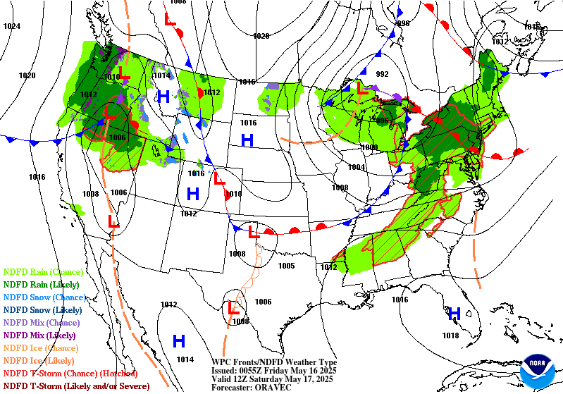
Day 3
Valid 12Z Sat May 17 2025 - 12Z Sun May 18 2025
...THERE IS A MARGINAL RISK OF EXCESSIVE RAINFALL FROM CENTRAL
TEXAS THROUGH NORTHERN ALABAMA AS WELL AS FOR PORTIONS OF THE
NORTHEAST...
...Texas to Alabama...
Another round of afternoon and evening thunderstorms is expected
from northeast Texas into northern Alabama Saturday and Saturday
night. Continued influx of Gulf moisture and instability on
southerly flow will clash with the cooler, dry air mass behind a
cold frontal passage over much of the Midwest on Friday. The storms
will form along this frontal interface. With that said, the forcing
in the upper levels should be greatly reduced over this region as
compared with previous days, as the upper forcing on Saturday will
be associated with a fast moving and weaker shortwave. This should
limit the coverage of storms. Once again however, recent heavy
rains in this area continue to keep the soils wet, and therefore
more prone to flash flooding. Should the forcing increase or amount
of moisture off the Gulf increase compared to current forecasts,
then it's possible a targeted Slight may eventually be needed,
with the DFW Metroplex area currently appearing to be at greatest
risk for an upgrade.
...Northeast...
Periods of heavy rain will move across the Northeast Saturday
afternoon ahead of a potent upper level low moving across the Great
Lakes. The storms will occur ahead of the upper low. There is some
uncertainty on storm coverage and intensity with moisture amounts
being limited in this area, but it is made up for by wetter than
average soils in this area of New England and New York. The
inherited Marginal Risk was trimmed out of most of Maine, as soils
there are drier than normal, which should allow any rainfall (which
should be less than an inch) to be absorbed by the dry soils.
The greatest flash flooding risk is likely in the Green and White
Mountains where terrain will worsen any potential flash flooding.
Wegman
Day 3 threat area:
www.wpc.ncep.noaa.gov/qpf/99epoints.txt


