Excessive Rainfall Discussion
NWS Weather Prediction Center College Park MD
843 PM EDT Wed May 14 2025
Day 1
Valid 01Z Thu May 15 2025 - 12Z Thu May 15 2025
...THERE IS A SLIGHT RISK OF EXCESSIVE RAINFALL FOR PORTIONS OF
THE MID-ATLANTIC INTO THE CENTRAL APPALACHIANS...
...Mid-Atlantic and Appalachians...
Given the trends in late afternoon/early evening satellite
imagery...trimmed some of the southern territory of the Marginal
and Slight risk areas where the axis of the negative tiled trough
has cleared the area. Farther north...maintained the outlook given
the surface dewpoints around 60 degrees with modest mid-level lapse
rates yielding surface based CAPE values around 1500 J per kg from
northern western Maryland to southeast Virginia. The expectation
is for convection to weaken with sunset...but rainfall rates as
high as 1 to 1.5 inches remain possible until then with spotty
rainfall totals perhaps reaching 2 inches. AND FOR PORTIONS
OF THE NORTHERN PLAINS...Given the recent heavy
rainfall in some of these places since Tuesday....there is somewhat
greater concern for run off.
...Northern Plains...
Expanded the coverage of the Marginal Risk area southward across
portions if Nebraska and a bit eastward on the eastern fringe.
Thunderstorms capable of producing heavy rainfall have developed in
portions of Nebraska in a region of strong deep layer convergence
on the eastern side of a moisture gradient in a region with surface
based CAPE values between 1500 and 2500J per kg. Large hail
signatures have likely resulted in over-estimation of radar based
rainfall amounts...but ground-truth of rainfall exceeding 1.25
inches in under an hour was reported from Mullen NE earlier. With
storm motion being slowed by height falls associated with the
approach of a shortwave trough from Colorado...localized totals
exceeding 2 inches seem likely with an additional 2 to 2.5 inches
possible meaning isolated 3 to 4 inch amounts may occur locally.
Given the sandy soils around the Sand Hills should handle most of
the rainfall but may still not have enough infiltration of
preclude at least some run-off/localized flooding or ponding. The
area of convection should become more progressive later this
evening once the shortwave from Colorado over-takes it. Farther
north...high resolution guidance draws a plume of moisture
northward or northwestward from the Nebraska convection into the
Dakotas. The airmass there was only moderately unstable but still
enough CAPE to support 0.5 to 1.0 inch per hour rates for a couple
hours following sunset that results in some flash flooding
conditions through approximately 15/04Z or so.
16Z Update: After last nights shift of the QPF maxima further west,
the guidance has come into agreement with little run to run
variability when assessing the two main CAMs periods. The
antecedent dry soils will be the "scale tipper" to the MRGL side of
the threat as convective premise will likely be more of a welcomed
sight, initially with some localized flood prospects in the Western
High Plains most likely incurring due to hydrophobic soils if
rainfall rates breach 2"/hr, or similar rates impacting a town with
more runoff potential given urbanization factors. The nocturnal MCS
development off the Front Range into SD/NE will be worth
monitoring, but if the convection leans closer to the Sandhill
domain along those borders into NE, the threat for flash flooding
will likely be muted outside of direct impacts on any towns in the
path of the complex. The MRGL risk was relatively unchanged given
the above factors, but pending the output from the first round of
convection along the lingering surface trough in conjunction with
the secondary convective onslaught anticipated this evening, a
targeted upgrade could be plausible. This is something we will
monitor as the day progresses.
Kleebauer
..Previous Discussion..
A deep upper level trough centered over the Intermountain West this
morning will become negatively tilted as an impressive shortwave
draws plentiful upper level energy into the northern Plains.
Surface cyclogenesis is expected ahead of this trough over Kansas,
which will track NNE into south-central North Dakota by Thursday
morning. A line of convection associated with the leading/eastern
edge of the trough is moving into far western South Dakota from
Wyoming, and this line of storms will track NNE over the western
Dakotas through the morning. The primary flooding threat will be
from a new line of storms which will develop over western South
Dakota with peak heating this afternoon, then track very slowly
eastward, as embedded cells move north, parallel to the line. This
will result in some training of convection, leading to an isolated
flash flooding threat.
In coordination with UNR/Rapid City, SD; FSD/Sioux Falls, SD; and
ABR/Aberdeen, SD forecast offices, the inherited Slight Risk was
removed with this update, and the surrounding Marginal shifted well
to the west of inherited. The westward shift was due largely to a
shift in the guidance slowing the forward motion of the trough.
While this increased forecast rainfall amounts some, the area of
the Dakotas now highlighted is in Moderate to in some localized
cases Severe drought. NASA SPoRT soil moisture imagery shows the
area has next to no moisture. Thus, despite the potential for heavy
rainfall at times in some areas, the flooding threat was
determined to be isolated.
Wegman
...Ohio Valley...
Scattered convective activity within an elevated moisture advection
regime will occur this afternoon and evening with the greatest
coverage anticipated in the evening thanks to added forcing from a
mid-level perturbation moving up from the southwest. Sufficient low
to mid-level buoyancy coupled with elevated PWATs will help with
locally heavy rainfall potential across areas extending from
Southern IN down into KY with totals potentially reaching between
1-3" in the strongest convective impacts. 12z neighborhood probs
for >2" are modest (20-40%) across the above area with some
elevated probs for >1" (50-70%) in the same locale. Considering the
nature of the soil anomalies >80% within areas of Eastern KY into
the Ohio River basin in conjunction with the heavier rainfall
rates, a MRGL risk was expanded westward to encompass the threat.
Kleebauer
...Michigan...
Near record daily PWATs (12z KAPX sounding of 1.37") and
anticipated lake breeze initiation thanks to strong differential
heat flux off Lake Michigan will generate a period of slow-moving
strong convective cores capable of rainfall rates of 1-2"/hr during
anticipated impact. Modest 10-year ARI exceedance probs based on
the latest hi-res ensemble suite (15-30%) across Northwest MI
signal a modest threat for localized flash flood concerns over any
urban zones within stronger convective cores. The key is the slower
mean storm motions anticipated with much of the convective
development likely anchored to the lake breeze and subsequent
outflow generation. Ensemble mean areal average QPF around 0.5-1"
with deterministic maxima between 2-3" was enough to warrant a
targeted MRGL risk issuance within a zone situated west of I-75 and
just north of I-96 in Lower MI. This is the primary area of concern
with the greatest threat up closer to Traverse City and points just
south.
Kleebauer
Day 1 threat area:
www.wpc.ncep.noaa.gov/qpf/94epoints.txt
Excessive Rainfall Discussion
NWS Weather Prediction Center College Park MD
849 PM EDT Thu May 15 2025
Day 1
Valid 01Z Fri May 16 2025 - 12Z Fri May 16 2025
...THERE IS A MARGINAL RISK OF EXCESSIVE RAINFALL FOR PORTIONS OF
THE NORTHERN PLAINS AND PARTS OF THE CENTRAL MIDWEST/OHIO
VALLEY...
Maintained the Marginal risk over portions of the Midwest/southern
Great Lakes region along and ahead of a QLCS from the Great Lakes
region overnight. The progressive nature of the system should
mitigate some of the flash flooding risk caused by locally intense
rainfall rates and reflects only a minor change to the on-going
Marginal risk area. Farther to the east...removed the Marginal risk
area from eastern Pennsylvania southward into the Carolinas where
the airmass has less instability and most of the high
resolution/convective allowing guidance has little convection
moving into the area prior to 12Z on Friday.
Across the Northern Plains...guidance continues to focus the risk
of locally heavy rainfall near the upper level low meandering
eastward overnight with 1 to 1.5 inch amounts possible. Given some
overlap with areas where flash flood guidance has been lowered by
recent moderate to heavy rainfall...saw little reason to deviate
much from the previous outlook.
Bann
Day 1 threat area:
www.wpc.ncep.noaa.gov/qpf/94epoints.txt
Excessive Rainfall Discussion
NWS Weather Prediction Center College Park MD
849 PM EDT Thu May 15 2025
Day 2
Valid 12Z Fri May 16 2025 - 12Z Sat May 17 2025
...THERE IS A SLIGHT RISK OF EXCESSIVE RAINFALL FOR MUCH OF THE
OHIO VALLEY...
20Z Update: A minor expansion of the SLGT risk was added to
encompass much of Eastern TN with emphasis on the I-75 area and
adjacent Smokey Mountains. There's a solid consensus on how the
nocturnal QLCS will progress with the line likely to move ESE out
of KY the centroid of the complex likely to follow a well-defined
theta_E gradient positioned from Western KY down through Eastern
TN. 12z HREF is now depicting the full time frame for the D2 and
pretty much all CAMs has the heaviest axis of precip bisecting the
area over Southern KY down into the northern tier of TN with a
western inflection near Paducha and eastern inflection towards the
I-75 corridor between Knoxville/Chattanooga. Areal average QPF is
now upwards of 2-3" with local maxima as high as 5", a range that
will cause flash flood issues within a large area of above normal
soil moisture anomalies as indicated via the latest NASA SPoRT
output. A high-end SLGT is now forecast within the zone above with
a broad SLGT risk still encompassing the rest of KY, the northern
two-thirds of TN, and the Ohio River basin covering Southern
IL/IN/OH into WV. A targeted upgrade is not out of the question in
the coming updates, but the progressive nature of the precip maybe
the biggest saving grace for the setup.
Scatterd bouts of thunderstorms across PA and Ohio will offer some
isolated threats of flash flooding due to compromised soils thanks
to the preceding convective impacts the days prior. There's some
potential for an initial complex to move out of the Tennessee
Valley into the Central Mid Atlantic on Friday evening, however
there's only a few pieces of guidance offering the potential, so
have foregone a small MRGL expansion into the region, but will be
something to monitor with trends in the CAMs in future updates.
Kleebauer
..Previous Discussion..
A stalled and shearing apart occluded front over the Ohio Valley
early Friday morning will dissipate through the day as its
associated rainfall ends. However, a reinforcing strong shortwave
will round the southern periphery of the vertically stacked low,
which will be pushing east from the Northern Plains and into the
upper Great Lakes. This shortwave and associated push of cooler air
in the form of a cold front will tap into the moisture and
instability largely in place ahead/southeast of the cold front over
the Ohio Valley, resulting in multiple areas of storms forming
Friday afternoon from southern Illinois through West Virginia.
While some training is possible as the storms are forming, they're
likely to develop into a single line, where any training would be
from pre-line convection that will likely be moving into and being
absorbed by the line. The line of storms will continue south into
the Mid-South through Friday night, albeit with lessening flash
flooding potential as the line becomes the only area of storms
around. As with areas further east, soil moisture levels all up and
down the Ohio Valley are at or above normal for this time of year,
and the presence of moisture to the order of 1.5 to 1.75 inches of
PWAT will support strong thunderstorms capable of 2+ inch/hour
rainfall rates. Given the sensitivities of the rivers and streams
in the area, the combination of heavy rain and sensitive soils
supported the continuance of the Slight Risk area, with some
expansions included to account for more the suite of guidance.
Wegman
Day 2 threat area:
www.wpc.ncep.noaa.gov/qpf/98epoints.txt
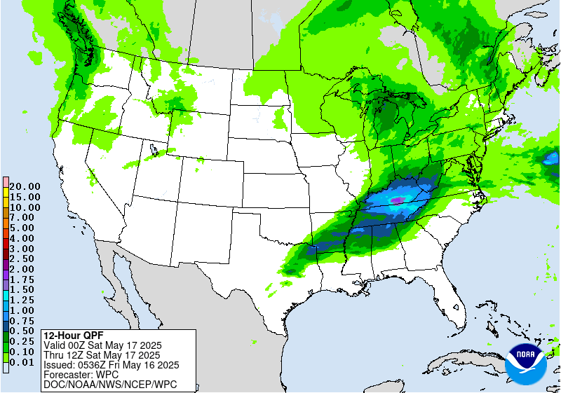
Excessive Rainfall Discussion
NWS Weather Prediction Center College Park MD
849 PM EDT Thu May 15 2025
Day 3
Valid 12Z Sat May 17 2025 - 12Z Sun May 18 2025
...THERE IS A MARGINAL RISK OF EXCESSIVE RAINFALL FROM CENTRAL
TEXAS THROUGH NORTHERN ALABAMA AS WELL AS FOR PORTIONS OF THE
NORTHEAST...
20Z Update: Little changes were necessary for either risk area for
the period. Deterministic variance in QPF maxima and orientation of
the overall precip footprint limited the ability for any potential
upgrade across the risk area over the Southern Plains through the
Mississippi Valley. There's a chance there is some expansion to the
north pending the evolution of a smaller mid-level vorticity maxima
ejecting eastward out of the Southern Rockies. Guidance is split on
the handling of the shortwave energy, so there could be some
additional MRGL risk coverage to the north near the OK/KS/MO/AR
intersection. With more time for resolution, decided to maintain
the nil in the location, but will monitor over subsequent updates.
The MRGL across the Northeast U.S. remains within the lower end of
the risk threshold with the best chances likely within the valleys
tucked into the Green and White Mountains. Scattered convective
coverage will allow for localized QPF maxima between 1-2" with
potential for rates to reach ~1"/hr at peak intensity. The
environment remains moist with PWAT anomalies between +1 to +2
deviations, enough to typically concern flash flood prospects
within the complex terrain of Northern New England. The inherited
MRGL was maintained with no real change.
Kleebauer
..Previous Discussions..
...Texas to Alabama...
Another round of afternoon and evening thunderstorms is expected
from northeast Texas into northern Alabama Saturday and Saturday
night. Continued influx of Gulf moisture and instability on
southerly flow will clash with the cooler, dry air mass behind a
cold frontal passage over much of the Midwest on Friday. The storms
will form along this frontal interface. With that said, the forcing
in the upper levels should be greatly reduced over this region as
compared with previous days, as the upper forcing on Saturday will
be associated with a fast moving and weaker shortwave. This should
limit the coverage of storms. Once again however, recent heavy
rains in this area continue to keep the soils wet, and therefore
more prone to flash flooding. Should the forcing increase or amount
of moisture off the Gulf increase compared to current forecasts,
then it's possible a targeted Slight may eventually be needed,
with the DFW Metroplex area currently appearing to be at greatest
risk for an upgrade.
...Northeast...
Periods of heavy rain will move across the Northeast Saturday
afternoon ahead of a potent upper level low moving across the Great
Lakes. The storms will occur ahead of the upper low. There is some
uncertainty on storm coverage and intensity with moisture amounts
being limited in this area, but it is made up for by wetter than
average soils in this area of New England and New York. The
inherited Marginal Risk was trimmed out of most of Maine, as soils
there are drier than normal, which should allow any rainfall (which
should be less than an inch) to be absorbed by the dry soils.
The greatest flash flooding risk is likely in the Green and White
Mountains where terrain will worsen any potential flash flooding.
Wegman
Day 3 threat area:
www.wpc.ncep.noaa.gov/qpf/99epoints.txt
Extended Forecast Discussion
NWS Weather Prediction Center College Park MD
300 AM EDT Fri May 16 2025
The notable surface low pressure system consolidated over the
central Plains by Monday will draw in above average moisture (with
precipitable water values around the 90th percentile for this time
of year) and ample instability ahead of its associated cold front.
The upper low spinning aloft will provide good dynamical lift, and
this combination of ingredients will lead to widespread rain and
thunderstorms and mesoscale convective systems, with best chances
slowly progressing east from the central to east-central to eastern
U.S. as next week progresses. The greatest chances for heavy rain
causing flash flooding look to be across the Mid-Mississippi and
western Ohio Valleys Monday and Tuesday, as moisture and
instability pool near a warm front stretching west-east that could
promote training storms. Thus Slight Risks are in place for the Day
4/Monday and Day 5/Tuesday ERO over pretty similar areas before
the upper/surface lows eject eastward. Broad Marginal Risks
surround the Slights to the south and east where convection may be
more scattered, and on Monday a Marginal curls back west closer to
the ow track. Severe weather is also possible per the Storm
Prediction Center, as they delineate possible severe areas on
Monday for the south-central Plains toward the Lower/Middle
Mississippi Valley on Tuesday. Rain and thunderstorm potential
should press toward the Eastern Seaboard by mid to late week.
Some precipitation is forecast in the Intermountain West under the
upper trough/low for the first half of next week. The cool
temperatures aloft could lead to May snow in higher elevations of
the Rockies particularly Monday. Convective showers are possible
near the Four Corners region. Meanwhile rounds of modest
precipitation may be possible in the Northwest. Light rain may
linger in the Northeast early next week under the influence of a
northern trough.
Warm to hot temperatures are likely across the southeastern U.S.
as the subtropical upper ridge reaches the region. Southern Texas
in particular will remain hot, with temperatures well into the 100s
leading to Major to Extreme HeatRisk. The Florida Peninsula should
see warm temperatures in the mid to upper 90s. Both areas could
see record or near record warm lows and highs. Meanwhile the trough
aloft will promote below normal temperatures, especially for
highs, across the Interior West Monday and into the northern Plains
Tuesday. Below average highs by around 10 degrees are also
possible in the northern tier. As the trough tracks east, cooler
than average temperatures should shift into the eastern third of
the country under it. This may also moderate the temperatures
somewhat in the South. But upper ridging poking into the West will
raise temperatures to above normal there by later week, bringing
highs well into the 100s for the Desert Southwest.
Tate


