Excessive Rainfall Discussion
NWS Weather Prediction Center College Park MD
856 PM EDT Fri Jun 20 2025
Day 1
Valid 01Z Sat Jun 21 2025 - 12Z Sat Jun 21 2025
...THERE IS A SLIGHT RISK OF EXCESSIVE RAINFALL FOR PARTS OF THE
UPPER MIDWEST...
01Z Update...
With the convection now dissipated, the Marginal Risk area over
Iowa was removed.
Elsewhere, made minor adjustments based on current observation
trends and recent hi-res guidance. A Slight Risk was maintained
from the central North Dakota-Minnesota border through northern
Minnesota into far northwestern Wisconsin. Recent runs of the HRRR
and the HREF generally agree on an axis of moderate to heavy
amounts across this area, with the 18Z HREF continuing to indicate
1+ in/hr rainfall rates, producing localized accumulations over 2
inches in this area.
Pereira
Previous Discussion...
...Northern Plains into Upper Midwest...
Model guidance indicates a well-defined mid level shortwave will
eject east out of the Rockies and into the Northern Plains this
afternoon into tonight, with a surface low moving from southern MT
into the Dakotas. High res guidance show convection developing near
the MT/ND border this afternoon to the north of a warm front. An
increasing low level jet by evening likely supports upscale growth
of this activity as it moves eastward across ND. This convection
will likely be quick-moving; however, 1"+ per hour rainfall appears
probable (up to around 70% chance in the HREF neighborhood probs)
and a localized flash flood risk is possible. A Marginal risk was
expanded west into these areas.
A Slight risk was maintained across portions of northern/northeastern
MN into far northern WI. An impressive low level jet and moisture
transport axis will quickly evolve this evening into the overnight
hours. CAMs forecast a pool of extreme instability on the order of
4000-5000 J/kg and PWs increasing towards 2". While the progressive
MCS tracks east across ND, we should see some downstream
development over eastern ND into northern MN on the nose of this
intense low level jet and along the instability gradient. Some
west-to-east training of this activity is possible ahead of the
upstream MCS that will also eventually push across the area.
The degree of training remains a bit unclear, but the 12Z CAMs
show max rainfall through 12Z of 3-5". Given the instability and
moisture in place, totals of this magnitude do seem plausible. Also
some uncertainty on the axis of heaviest rainfall, which should
end up pretty narrow. The better instability will be south, however
a strong mid level cap will be advecting northward likely putting
a limit on how far south organized convection will get. The current
Slight risk area encompasses the highest HREF probabilities, and
while a bit broader than what will probably happen, accounts for
some latitudinal uncertainty. Overall think isolated to scattered
flash flooding could evolve from this setup, especially if there is
overlap with the heavy rainfall axis from a couple days ago over
northeast MN.
Just southeast of the southeastern side of the Marginal risk (into
Lower Michigan), a few 12Z CAMs show an area of developing rain
this evening/overnight along a boundary (with potentially heavier
amounts >3"), but confidence in this scenario is quite low as some
other CAMs are basically dry.
...Northern Rockies...
A strong mid-level low moving into the Pacific Northwest will
focus impressive synoptic ascent over MT today into tonight. Even
this morning, convection has blossomed over northwestern Montana
which will expand some this afternoon. PWs near the climatological
90th percentile supports some heavier rates/amounts. Instability is
likely the main limiting factor for excessive rainfall, and the
probability of exceeding 1" per hour rain is pretty low (10-40%)
because of this. However do think we will get some weak
instability, which combined with the impressive dynamics, should
still allow for some embedded heavier convective cores with over
0.5" per hour rain (which was estimated per MRMS around 15Z). Most
areas will probably see closer to 1" of rain; however, localized
amounts over 2" are supported by the high res models which could
result in an isolated flash flood risk.
Fracasso/Chenard
Day 1 threat area:
www.wpc.ncep.noaa.gov/qpf/94epoints.txt
Excessive Rainfall Discussion
NWS Weather Prediction Center College Park MD
657 AM EDT Sat Jun 21 2025
Day 1
Valid 12Z Sat Jun 21 2025 - 12Z Sun Jun 22 2025
...THERE IS A MARGINAL RISK OF EXCESSIVE RAINFALL FOR PORTIONS OF
THE NORTHERN GREAT LAKES, INTERIOR NORTHEAST, AND NORTHERN
ROCKIES...
11Z Update...
Expanded Marginal Risk south to match and be ahead of ongoing
activity in northern Wisconsin that has a training threat as it
shifts east over the northern Lower Peninsula of Michigan this
morning through midday.
Jackson
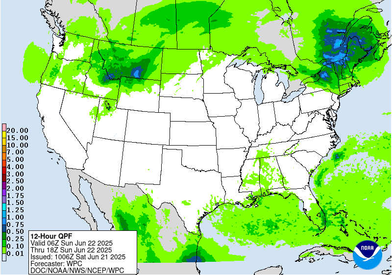
...Northern Great Lakes...
Convection will likely be ongoing at 12z this morning across
portions of the UP of MI. It still looks like the storm mode should
be a progressive squall line, which would limit the duration of
heavy rainfall and flash flood risk. However even the progressive
convection will be capable of heavy rates, with a high likelihood
of some 1"+ per hour totals, and a low chance of 2" per hour. Also
can not rule out some brief backbuilding/training on the southwest
flank of convection as it moves eastward. So while the flash flood
risk should be relatively low, localized hydrologic issues can not
be ruled out this morning. Convective and model trends suggest the
better threat is over the UP of MI, and so we were able to cut
back on the southern extent of the inherited risk area with this
update.
...Northeast...
Not expecting much convection during the day across the Northeast,
however an uptick in activity is possible overnight into early
Sunday. By tonight steeper lapse rates advect into the region,
resulting in what should be a pretty rapid increase in MUCAPE over
western NY into portions of VT and NH. The ongoing MCS over MN and
MI should weaken as it approaches the Northeast this evening as
instability will not have increased yet. However the parent mid
level shortwave will remain upstream and expect an additional area
of organized convection to develop with this over southern Canada.
It is this next round that has a better chance of surviving into
portions of NY/VT/NH by later tonight.
The details of this remain unclear, but there should be enough
instability and low level moisture transport/convergence to
sustain some level of activity into the Northeast. Most indications
from the 00z high res guidance is for a quick moving area of
convection, and thus rainfall totals are not overly impressive.
However given the ingredients in place there does seem to be some
potential for an over performing area of convection with some brief
backbuilding characteristics. The better chance of this would be
along the instability gradient and southwest flank of
activity...probably central/upstate NY and/or portions of VT/NH. A
Marginal risk continues to suffice given the 00z suite of
models...however will need to closely monitor observational and
model trends through the day. Depending on how things evolve later
tonight into early Sunday there is some chance for an embedded
more focused flash flood risk within the broader Marginal, and can
not rule out the eventual need for a Slight risk.
...Northwest Montana...
A Marginal risk was maintained across portions of northwest MT
where rainfall will continue into today. By this time this region
will be within the comma head of the low, and looking at more
stratiform rain with lower rates. Thus probably not really a flash
flood risk by this point, but with an additional 1-3" of rain
pushing storm total rainfall towards 4" in spots, some possible
flood impacts still justify a Marginal risk. Snow levels will drop
towards 4000 feet by this time as well, so flood impacts will stay
below that level.
Chenard
Day 1 threat area:
www.wpc.ncep.noaa.gov/qpf/94epoints.txt
Excessive Rainfall Discussion
NWS Weather Prediction Center College Park MD
657 AM EDT Sat Jun 21 2025
Day 2
Valid 12Z Sun Jun 22 2025 - 12Z Mon Jun 23 2025
...THERE IS A SLIGHT RISK OF EXCESSIVE RAINFALL ACROSS PORTIONS OF
SOUTHEAST NEW MEXICO AND SOUTHWEST TEXAS...
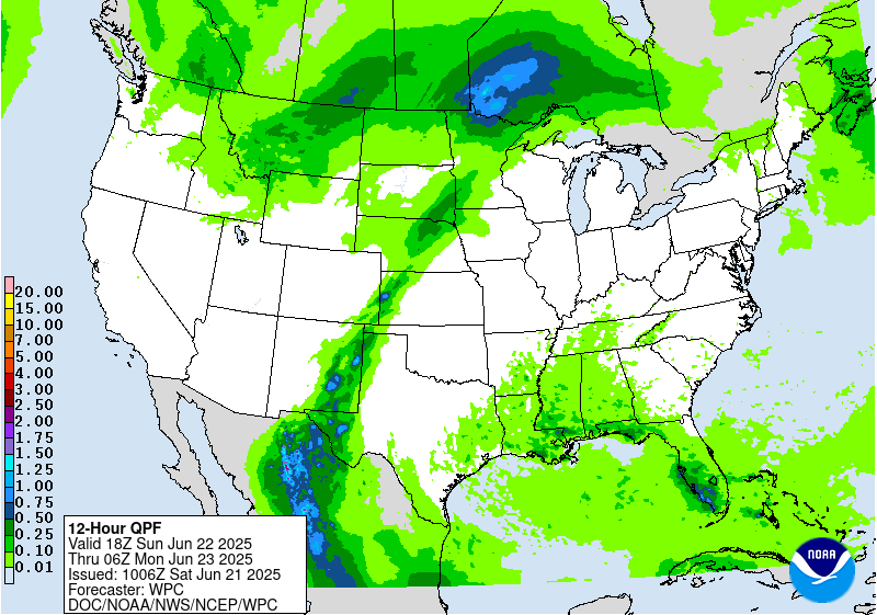
...New Mexico and Texas...
Sunday is likely the beginning of what will be a multi-day period
of excessive rainfall potential over portions of west TX into NM.
The mid/upper level pattern features a near record to record ridge
over the eastern U.S. and a well-defined longwave trough over the
west. Southerly flow in between these features will supply ample
moisture to NM, with a connection all the way to the Caribbean Sea.
The better forcing from the western trough will generally hold of
until Monday and Tuesday (see the day 3 and 4 EROs), but by Sunday
we should at least have enough moisture and instability around for
scattered convective development. In fact PWs by Sunday should
already be getting towards climatological max values for late June
over portions of southwest TX and immediate adjacent areas of NM.
And while the better forcing arrives Monday, do note broadly
divergent flow at 250mb Sunday which could help sustain convection.
Given these ingredients we went ahead and upgraded to a Slight risk
for portions of southwest TX into Otero and Eddy counties in NM.
Expecting enough convective development Sunday afternoon/evening,
that combined with the near record PWs, suggests an isolated to
scattered flash flood risk should evolve over these areas. A bit
of uncertainty with how far north the Slight should extend into NM
with some models supporting a farther north expansion. However the
area currently highlighted shows the best overlap of the
NAM/RRFS/ECMWF and likely has the higher probability of seeing
flash flooding at the moment. The broad Marginal risk does still
extend into much of the rest of eastern NM and covers the
localized risk over those areas.
...Northern Minnesota...
Went ahead and added a small Marginal risk over portions of
northern MN with this update. The setup looks favorable for another
round of organized convection Sunday afternoon and evening across
this region. Strong shortwave energy ejecting into the northern
Plains, a strengthening axis of low level moisture transport, and
upwards of 4000 j/kg of MUCAPE will drive the convective threat.
The combination of extreme instability, PWs well over the 90th
percentile for late June, and a warm front focusing convection, all
point to a heavy rainfall threat. Some uncertainty with the exact
axis of convection, with some guidance focusing the bulk of
convection farther north into Canada. However both GEFS and ECENS
probs suggest some risk into northern MN, and the AIFS (which has a
history of good convective qpf placement) also favors northern MN.
Quite possible convection ends up blowing through quickly, so no
need for anything more than a Marginal risk at this time. But will
need to continue to monitor trends over the coming days.
Chenard
Day 2 threat area:
www.wpc.ncep.noaa.gov/qpf/98epoints.txt
Excessive Rainfall Discussion
NWS Weather Prediction Center College Park MD
657 AM EDT Sat Jun 21 2025
Day 3
Valid 12Z Mon Jun 23 2025 - 12Z Tue Jun 24 2025
...THERE IS A SLIGHT RISK OF EXCESSIVE RAINFALL ACROSS PORTIONS OF
NEW MEXICO AND WEST TEXAS, AND FROM KANSAS INTO IOWA...
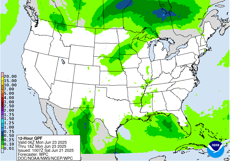
...Southwest...
The overall pattern over the Southwest described in the day 2
discussion will persist into the day 3 period. By day 3 forcing,
moisture and instability should all be on the increase, and thus
expect convective coverage and flash flood risk to be on the
rise as well. The gradual approach of the west coast trough will
bring the right entrance region of the upper jet closer, and
continued moisture advection in between the trough and the east
coast ridge will push PWs well above the climatological 90th
percentile and towards late June max levels. Instability is a bit
of a question as cloud cover debris from Sundays activity could
play a role...however the model consensus is for increased
instability compared to Sunday, with values averaging 1000-2000
j/kg over much of eastern NM into far west TX. Not a ton of deep
layer flow, so convection forming on/near terrain should slowly
move off the terrain and allow for some cell merger activity. The
expected convective coverage should eventually erode instability
enough that activity trends down by overnight...but not before what
should be a more widespread isolated/scattered flash flood risk
over eastern NM and west TX where a Slight risk remains. The
western edge of this risk area was adjusted eastward a tad, as
model trends now support a slightly farther east axis.
Some uncertainty on where any more focused risk could evolve, but
the better model clustering is over southwest TX into southeast NM
and consider the threat over this corridor a higher end Slight
risk. This includes the sensitive Sacramento Mountain burn scar
areas, where localized significant flash flood impacts are a
possibility.
...Central Plains to MS Valley...
A Slight risk remains from portions of central KS into southeast
NE and much of central and northern IA where convection along a
stationary front poses an isolated to scattered flash flood risk.
Model guidance indicates convective development along/near this
front Monday afternoon, with some persistence and/or upscale
development possible Monday evening as low level moisture
transport increases. Corfidi vectors over this area are divergent,
indicating a favorable environment for slow moving/backbuilding
convection near this front. PWs should be well over the 90th
percentile for late June along this front, as the same plume of
moisture over the Southwest will be in place here as well. Thus
any training of convection will pose a flash flood risk.
Maintenance of instability is probably the main question mark, as
the pool of forecast instability is not overly impressive and
neither is the magnitude of the low level jet...so the extent of
convective persistence into the overnight is a bit unclear.
Nonetheless, the unanimous model signal for organized convective
development, combined with the stationary front/convergence and
high PWs supports at least an isolated to scattered flash flood
potential. Thus the Slight risk was maintained. Overall models are
in fairly good agreement with the favored convective axis, and thus
not much change was needed to the inherited risk area.
Chenard
Day 3 threat area:
www.wpc.ncep.noaa.gov/qpf/99epoints.txt
Extended Forecast Discussion
NWS Weather Prediction Center College Park MD
300 AM EDT Sat Jun 21 2025
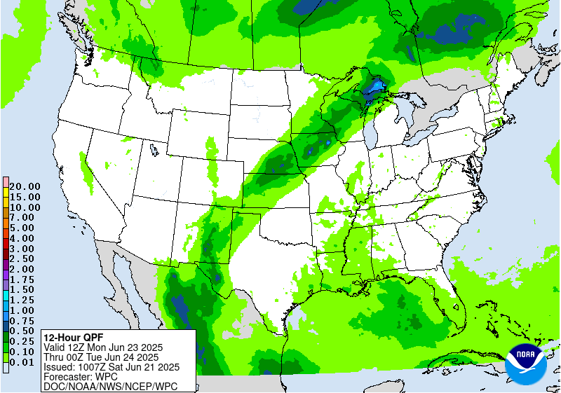
The upper trough/ridge pattern setting up across the lower 48 will
draw in ample tropical/subtropical moisture to the southern
Rockies/High Plains. The right entrance region of the upper jet
will provide support to develop and maintain rain and
thunderstorms, while moisture levels should be high. Specifically,
precipitable water values are likely to be over the 95th percentile
if not 99th, while instability will be sufficient for widespread
thunderstorms. New Mexico is likely to see the heaviest rain
through Tuesday. A Slight Risk remains in place across much of the
state for Day 4/Tuesday, which is considered a higher-end Slight
Risk given peak moisture parameters and wet antecedent conditions
by then. Areas like terrain and burn scars (particularly the
Sacramento Mountains) would be particularly sensitive. By Wednesday
and beyond, some moist inflow is likely to continue and maintain
rain chances, but the upper jet should get gradually weaker for
less support for heavy amounts. Thus for the new Day 5/Wednesday
ERO, show a Marginal Risk stretching from New Mexico into the
central High Plains.
Moisture is forecast to wrap northward and then eastward around
the upper ridge, spreading heavy rain potential into the north-
central Plains and Midwest in conjunction with shortwaves. A
meandering frontal boundary will focus this moisture on the cusp of
the instability gradient and lead to thunderstorms with
potentially heavy rain rates that could train west to east. Higher-
end Slight Risks are delineated in the Tuesday and Wednesday EROs
in this pattern, stretching from Nebraska and southeast South
Dakota into the Upper Midwest, with a bit of a northeastward shift
on Wednesday to follow the front and associated surface low
movement. The heaviest rain and storms may shift somewhat east into
the Upper Great Lakes region by Thursday while expanding into the
Mid-Atlantic and Northeast mid to later week as well.
Farther south, there is some uncertainty with how much convection
may occur under the upper ridge across the Gulf Coast and
southeastern U.S. as surface-based instability likely battles with
subsidence aloft. In general, scattered thunderstorms may increase
in coverage as the week progresses as the upper high gradually
weakens.
The strong upper high/ridge stretching across the south-central to
eastern U.S. will allow for well above average temperatures that
could approach or exceed daily records at a few dozen locations
through Tuesday. This translates into highs well into the 90s into
the low 100s, with heat indices to near 110F as dew points will be
in the 60s to low/mid-70s. Overnight lows will only drop into the
low/mid 70s for many areas, and even may stay around 80F in the
urban centers like Washington, D.C., Baltimore, Philadelphia, and
New York City. This will bring little relief from the heat and
exacerbate potential impacts. Thus, HeatRisk values will be Major
to Extreme for portions of the Midwest and Ohio Valley to Eastern
states -- levels 3 and 4 on a scale from 1 to 4 (4 being Extreme).
This indicates an intensity and duration of heat that is extremely
dangerous to anyone without adequate cooling or hydration. Extreme
heat is the number 1 weather-related killer. Temperatures will
remain above average, though a few degrees lower and with fewer
records possible, across much of the east-central and eastern U.S.
into the latter part of next week. But the Northeast should see
moderating temperatures after a cold frontal passage. Meanwhile,
temperatures (particularly highs) are forecast to be below average
by a few degrees in interior portions of the West and High Plains
into midweek, but should gradually warm closer to or a bit above
average as the week progresses.
Tate
Extended Forecast Discussion
NWS Weather Prediction Center College Park MD
300 AM EDT Sat Jun 21 2025
The upper trough/ridge pattern setting up across the lower 48 will
draw in ample tropical/subtropical moisture to the southern
Rockies/High Plains. The right entrance region of the upper jet
will provide support to develop and maintain rain and
thunderstorms, while moisture levels should be high. Specifically,
precipitable water values are likely to be over the 95th percentile
if not 99th, while instability will be sufficient for widespread
thunderstorms. New Mexico is likely to see the heaviest rain
through Tuesday. A Slight Risk remains in place across much of the
state for Day 4/Tuesday, which is considered a higher-end Slight
Risk given peak moisture parameters and wet antecedent conditions
by then. Areas like terrain and burn scars (particularly the
Sacramento Mountains) would be particularly sensitive. By Wednesday
and beyond, some moist inflow is likely to continue and maintain
rain chances, but the upper jet should get gradually weaker for
less support for heavy amounts. Thus for the new Day 5/Wednesday
ERO, show a Marginal Risk stretching from New Mexico into the
central High Plains.
Moisture is forecast to wrap northward and then eastward around
the upper ridge, spreading heavy rain potential into the north-
central Plains and Midwest in conjunction with shortwaves. A
meandering frontal boundary will focus this moisture on the cusp of
the instability gradient and lead to thunderstorms with
potentially heavy rain rates that could train west to east. Higher-
end Slight Risks are delineated in the Tuesday and Wednesday EROs
in this pattern, stretching from Nebraska and southeast South
Dakota into the Upper Midwest, with a bit of a northeastward shift
on Wednesday to follow the front and associated surface low
movement. The heaviest rain and storms may shift somewhat east into
the Upper Great Lakes region by Thursday while expanding into the
Mid-Atlantic and Northeast mid to later week as well.
Farther south, there is some uncertainty with how much convection
may occur under the upper ridge across the Gulf Coast and
southeastern U.S. as surface-based instability likely battles with
subsidence aloft. In general, scattered thunderstorms may increase
in coverage as the week progresses as the upper high gradually
weakens.
The strong upper high/ridge stretching across the south-central to
eastern U.S. will allow for well above average temperatures that
could approach or exceed daily records at a few dozen locations
through Tuesday. This translates into highs well into the 90s into
the low 100s, with heat indices to near 110F as dew points will be
in the 60s to low/mid-70s. Overnight lows will only drop into the
low/mid 70s for many areas, and even may stay around 80F in the
urban centers like Washington, D.C., Baltimore, Philadelphia, and
New York City. This will bring little relief from the heat and
exacerbate potential impacts. Thus, HeatRisk values will be Major
to Extreme for portions of the Midwest and Ohio Valley to Eastern
states -- levels 3 and 4 on a scale from 1 to 4 (4 being Extreme).
This indicates an intensity and duration of heat that is extremely
dangerous to anyone without adequate cooling or hydration. Extreme
heat is the number 1 weather-related killer. Temperatures will
remain above average, though a few degrees lower and with fewer
records possible, across much of the east-central and eastern U.S.
into the latter part of next week. But the Northeast should see
moderating temperatures after a cold frontal passage. Meanwhile,
temperatures (particularly highs) are forecast to be below average
by a few degrees in interior portions of the West and High Plains
into midweek, but should gradually warm closer to or a bit above
average as the week progresses.
Tate


