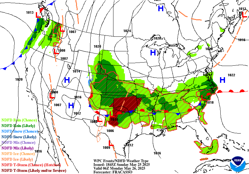
Excessive Rainfall Discussion
NWS Weather Prediction Center College Park MD
1144 AM EDT Sun May 25 2025
Day 1
Valid 16Z Sun May 25 2025 - 12Z Mon May 26 2025
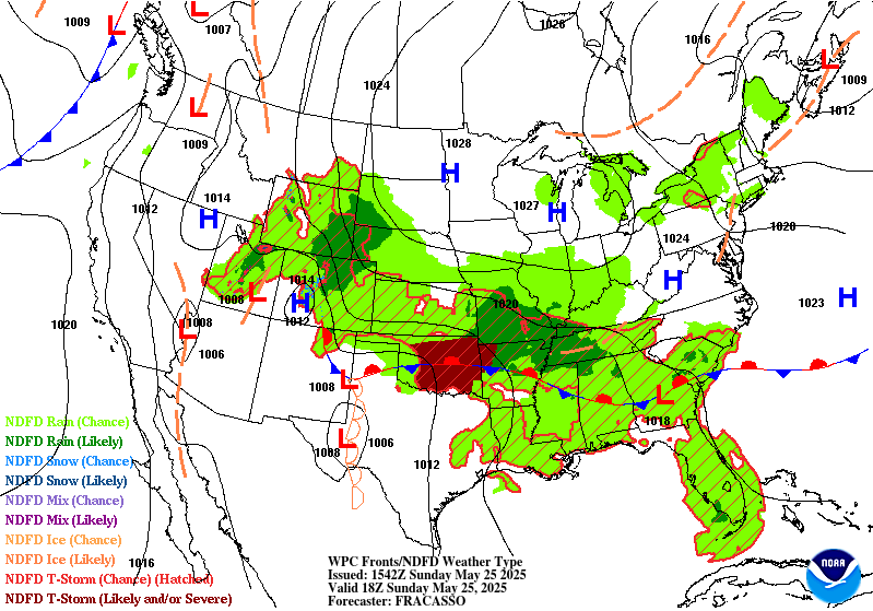
...THERE IS A MODERATE RISK OF EXCESSIVE RAINFALL FROM
CENTRAL OKLAHOMA TO EXTREME NORTHWESTERN ARKANSAS...
16Z Update:
It is looking more likely that a bimodal distribution will develop
with respect to the expected QPF across Oklahoma and the Red River
valley of northern Texas later this evening and into the overnight
hours. The northern portion of the Moderate Risk includes areas
that were hammered with flooding rain earlier this morning, and
additional rounds of convection expected through this afternoon
will be an aggravating factor for additional flooding. Farther to
the south, there will likely be a separate axis of enhanced QPF
where a large MCS develops this evening into the early overnight
hours in the generally vicinity of the Red River with repeated
rounds of slow moving convection, so the Moderate Risk area was
expanded south across more of southern Oklahoma to the Texas
border to encompass this potential. It is important to note that
some of the CAM guidance depicts this band of heavier rainfall
farther south across north-central Texas, so this will bear close
watching later today and a Slight Risk remains valid for this
region.
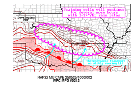
For the Southeast U.S., a Slight Risk has been added for portions
of southern South Carolina and into eastern portions of Georgia,
including the greater Charleston and Savannah metro areas. There
has been a general upward trend in QPF magnitudes in the latest 12Z
CAM guidance, and although the coverage will generally be
scattered, there will likely be some slow moving cells with
impressive rainfall rates that develop this afternoon as an MCV
approaches the region. For additional mesoscale information
pertaining to this, please reference MPD #313 that has been
recently issued.
The previous overnight discussion is appended below for reference.
Hamrick
------------------------
...Southern Plains to the Mid-South/Tennessee Valley...
Convection now developing over the central High Plain is expected
to gradually grow upscale through the remainder of the overnight as
it moves further east into a region of deeper moisture associated
with a low level warm front. Storms will likely be ongoing, with
areas of heavy rain impacting portions of southeastern Kansas,
northeastern Oklahoma, and the Ozarks as this system crosses the
region through the remainder of the morning into afternoon hours.
Some storms may persist and reintensify as they move east of the
Ozarks, bringing a heavy rain threat and some potential for flash
flooding into the Mid-South and Tennessee Valley by the afternoon.
A lingering boundary and moisture will help support redeveloping
convection back to the west across Oklahoma into the Texas
Panhandle by the afternoon. These storms are also expected to grow
upscale as the low level jet across Texas intensifies ahead of an
upper trough moving across the Southwest. Moisture pooling on the
nose of the low level jet (PWs ~1.75 in) within a region of strong
ascent is expected to support the development of a convective
complex, with heavy rains moving east near the Red River through
the overnight.
Forecast confidence is limited by differences shown by the CAMs
regarding how this convection will evolve and their placement of
heaviest amounts. Relied on the HREF to make adjustments to the
previous outlook, which included shifting the Moderate Risk area
further south across central/eastern Oklahoma and western
Oklahoma. With possible contributions from both this morning's
activity and the storms expected to follow this evening and
overnight, the HREF is showing some of its highest neighborhood
probabilities for amounts over 3 inches over this area. This also
corresponds with an area of relatively lower flash guidance,
reflecting some locally heavier totals that have fallen over the
past 24-hrs. Maintained the Slight Risk as far west as the eastern
Texas Panhandle, where this second round is expected to become
better organized this evening. Also brought the Slight Risk
further south across Northeast Texas, where some of the guidance
shows slow-moving, heavy rain producing storms developing along a
boundary ahead of the system.
...Front Range into the Central High Plains...
Anomalous moisture supported by low level easterly flow is expected
to fuel additional showers and thunderstorms developing along the
terrain before moving east, with some threat for locally heavy
amounts and isolated flash flooding concerns. Easterly winds along
the northern extent of a low centered over the southern High Plains
will continue to support standardized PW anomalies over 1.5 sigma,
which along with daytime heating and ascent afforded by a mid-
level shortwave and right-entrance region forcing is expected to
support storm development. A Marginal Risk was maintained from the
Front Range eastward into southwestern Nebraska, where the HREF is
showing high neighborhood probabilities for accumulations over an
inch, along with some notable probabilities for amounts over 2
inches along the high terrain.
...Florida and Georgia/South Carolina coasts...
A stalled frontal boundary will remain across central Georgia and
the SC Low Country. Southerly flow along the western extent of the
subtropical ridge will support deepening moisture along and south
of the boundary, reaching ~1.75 inches in some locations. This
moisture along with daytime heating and enhanced convergence along
land-sea interactions, will support showers and thunderstorms
capable of producing locally heavy rates and perhaps isolated flash
flooding concerns, especially in urbanized areas. A Marginal Risk
was drawn for areas from the SC Low Country to South Florida,
where the HREF shows high neighborhood probabilities for
accumulations exceeding 2 inches.
Pereira/Hamrick
Day 1 threat area:
www.wpc.ncep.noaa.gov/qpf/94epoints.txt
Excessive Rainfall Discussion
NWS Weather Prediction Center College Park MD
1144 AM EDT Sun May 25 2025
Day 2
Valid 12Z Mon May 26 2025 - 12Z Tue May 27 2025
...THERE IS A SLIGHT RISK OF EXCESSIVE RAINFALL FROM THE SOUTHERN
PLAINS TO THE TENNESSEE VALLEY...
Overall, not much change to the previous forecast. The shortwave
associated with the previous night's convection over the Southern
Plains is expected to move out across the Mississippi Valley into
the Mid-South. This along with trailing energy moving from the
Southwest into the Plains will help shift the axis of deeper
moisture and the greater potential for heavy rainfall further south
and east. Expect the initial wave to carry with it some threat for
heavy rain and flash flooding into the Mid-South and the TN/lower
Ohio Valleys as it helps direct deeper moisture into the those
regions late Monday into early Tuesday. However, perhaps the
bigger threat for heavy rain and possible flash flooding will focus
further to the southwest along a boundary left in the wake of this
system. Southerly flow ahead of a wave moving across the Southern
Plains maintaining deep moisture, along with right-entrance region
upper jet forcing providing large scale ascent, are expected to
generate an environment favorable for heavy rainfall. Some of the
overnight guidance continues to show impressive amounts extending
across parts of Northeast Texas into the ArkLaTex. There is still
enough uncertainty to withhold an upgrade to a Moderate, but will
continue to monitor.
Pereira
Day 2 threat area:
www.wpc.ncep.noaa.gov/qpf/98epoints.txt
Excessive Rainfall Discussion
NWS Weather Prediction Center College Park MD
1144 AM EDT Sun May 25 2025
Day 3
Valid 12Z Tue May 27 2025 - 12Z Wed May 28 2025
...THERE IS A MARGINAL RISK OF EXCESSIVE RAINFALL EXTENDING FROM
THE SOUTHERN PLAINS TO THE MID ATLANTIC AND SOUTHEAST...
An expansive Marginal Risk was maintained from areas along and
east of the central/southern Appalachians back through the Ohio,
Tennessee, and lower Mississippi valleys and across Texas. While
one or more Slight Risk are likely forthcoming within this broad
area, opted to maintain the Marginal pending better model
agreement and forecast confidence in future runs. Areas for
potential upgrades include the upper Ohio Valley, where some
models show heavy amounts associated with energy moving out of the
central U.S. and across the top of a downstream ridge. Another
possible area is over the Tennessee Valley into the Southeast,
where energy moving out of the lower Mississippi Valley, along with
favorable upper jet forcing, may contribute to some higher totals.
Perhaps a more likely area will be associated with some of the
deeper moisture and greater instability back across South-Central
Texas. Some, but not all of the guidance, show mid-level energy
along with right-entrance region upper jet dynamics supporting
heavy amounts across the region Tuesday afternoon into the evening.
Pereira
Day 3 threat area:
www.wpc.ncep.noaa.gov/qpf/99epoints.txt


