Excessive Rainfall Discussion
NWS Weather Prediction Center College Park MD
1154 AM EDT Thu Jun 19 2025
Day 1
Valid 16Z Thu Jun 19 2025 - 12Z Fri Jun 20 2025
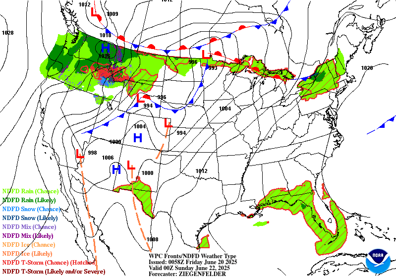
...THERE IS A SLIGHT RISK OF EXCESSIVE RAINFALL FOR PORTIONS OF THE
CENTRAL APPALACHIANS AND MID-ATLANTIC STATES...
...Central Appalachians, Mid-Atlantic, and the Northeast...
A potent shortwave will amplify as it tracks northeast from the
Great Lakes to along the northern New England/Canadian border,
potentially becoming negatively tilted by tonight. This will help
to deepen a surface low moving in tandem with its parent trough,
which will in turn drive the accompanying cold front rapidly to the
east. By 12Z Friday, this front should be offshore New England and
the Mid- Atlantic, but before that occurs scattered thunderstorms
with heavy rain are likely along it.
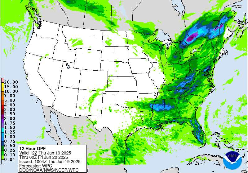
The downstream environment from this front is extremely favorable
for thunderstorms containing heavy rain. PWs will surge northward on
SW 850mb flow of 30 kts, reaching 1.75 to 2 inches, or higher, from
the Mid-Atlantic into New England, which will be above daily records
according to the SPC sounding climatology. This intense PW plume
will combine with a narrow corridor of MUCAPE progged to exceed 2000
J/kg from NC through ME, to support heavy rainfall within
convection. Although the CAMs are generally modest with their
coverage today, expect scattered to numerous thunderstorms to
develop during peak heating, with modest bulk shear of 25-30 kts
supporting at least isolated clusters in an otherwise pulse-type
environment. Due to the impressive PWs and tall skinny CAPE
profiles, max hourly rainfall could reach 2-3" according to the REFS
and HREF guidance, which would be sufficient to cause runoff and
isolated flash flooding.
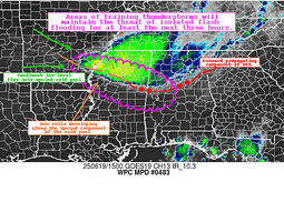
Although the flash flood risk today is generally isolated due to
fast storm motions and minimal training, there is a slightly higher
risk for impacts across the Central Appalachians, generally in WV
and PA, where antecedent conditions (7-day rainfall more than 400%
of normal according to AHPS) have resulted in severely compromised
FFG as low as 1"/3hrs. Despite progressive cell motion, HREF
exceedance probabilities rise to 15-25% in this area, and it is
possible that even fast-moving heavy rain producers could cause
impacts, so the SLGT risk has been maintained. Additionally, after
coordination with WFO LWX, a targeted SLGT risk has been added for
generally the I-95 urban corridor of northern VA and MD where the
high-res CAMs suggest some local focusing of thunderstorms this
afternoon with heavy rain which could produce as much as 3" of
rainfall atop sensitive areas which received heavy rain on
Wednesday.
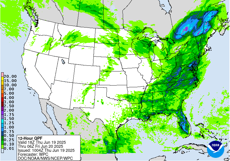
Farther north into New England, mean 0-6km winds remain quick at 20-
30 kts, but are more aligned parallel to the Corfidi vectors and the
front, suggesting an enhanced training risk. However, instability
and PWs are more modest, so rain intensity will be decreased as
forecast by lower 1"/hr rain rate probabilities from the HREF.
Although total rainfall could reach 3" in some areas from northern
VT through northern ME, the excessive rain risk remains in the MRGL
category.
...Southeast...
The same front that will race across the Mid-Atlantic and
Northeast, will trail back into the Southeast today. Although this
front is likely to decay by this evening, the residual convergence
zone will linger as it becomes embedded within more zonal flow
south of the primary trough. Convection ongoing early this morning
from AR to AL will weaken, but the accompanying outflow may merge
with the weakening front to provide additional impetus for
convective development thanks to robust thermodynamics
characterized by PWs of around 1.75 inches and MUCAPE of 2000-3000
J/kg. This will create scattered thunderstorms this aftn/eve with
rainfall rates of more than 2"/hr. Although there is some
uncertainty into how the weakening front will evolve (some CAMs
suggest the outflow will surge all the way to the Gulf Coast), any
storms that do form have the potential to train as Corfidi vectors
collapse to around 5 kts so storms could move west to east and
repeat through the evening. Both the HREF and REFS guidance
indicate a 30-40% chance of 3" of rain, which could produce
isolated flash flooding today.
...Florida Peninsula...
Bermuda-type ridge off the Southeast Coast will produce weak
easterly flow over the FL Peninsula today. As afternoon heating
commences and instability climbs above 2000 J/kg, scattered
afternoon thunderstorms will develop. Initially, these will occur
on the sea breeze, but as the Atlantic coast sea breeze pushes
westward and a weak jet streak develops downstream of a longwave
trough dropping across the Southeast, additional development is
likely along this boundary and due to storm mergers/boundary
interactions. This will likely be most prevalent near the SW coast
of FL where the Gulf Coast sea breeze will be pinned, fueling
multiple rounds of slow moving thunderstorms. With PWs progged
around 1.75", rainfall rates of 2-3"/hr are expected, producing
hourly rainfall as much as 3" according to both the RRFS and HRRR
models, and total rainfall over 5" possible (20-40%) in localized
areas. Should this rain occur atop more urban areas, especially
along the Sun Coast, instances of flash flooding could result.
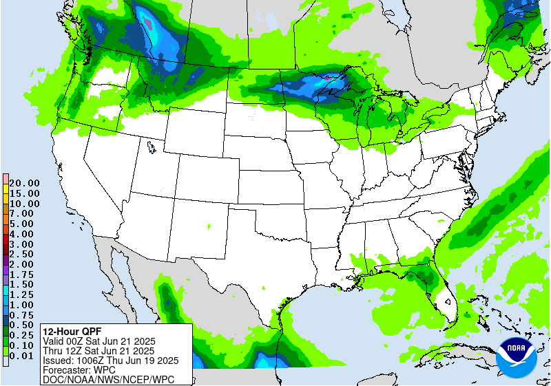
...Upper Midwest...
A cold front dropping out of Canada today will slow and stall
across Minnesota this evening in response to flattening 500mb flow
aloft as a ridge build atop the Southern Plains. Return flow
circling this expanding ridge will amplify tonight, with 850mb
winds potentially reaching above 50 kts on S/SW flow emerging from
the Central Plains and surging into the front. This LLJ will
resupply favorable thermodynamics into the region as reflected by
an overlap of PWs above 1.25 inches and MUCAPE exceeding 2000 J/kg
to support thunderstorm development. Storms that develop along this
boundary may train from WNW to ESE as mean winds parallel the
front, and with rain rate probabilities reaching 40-60% for 1"/hr,
2-3" of rain is possible as noted by the HREF PMM and 3"/24hr
probabilities reaching 20-30. Despite relatively high FFG, training
of these rain rates where they produce the locally higher stripes
of rain could cause instances of flash flooding tonight.
Weiss
Day 1 threat area:
www.wpc.ncep.noaa.gov/qpf/94epoints.txt
Excessive Rainfall Discussion
NWS Weather Prediction Center College Park MD
1154 AM EDT Thu Jun 19 2025
Day 2
Valid 12Z Fri Jun 20 2025 - 12Z Sat Jun 21 2025
...THERE IS A MARGINAL RISK OF EXCESSIVE RAINFALL FOR THE UPPER
MIDWEST AND PORTIONS OF THE NORTHERN ROCKIES...
...Upper Midwest...
Amplified mid and upper pattern across the Western CONUS into the
Northern Plains will lead to a stout area of low pressure
developing across the Western High Plains, moving east through the
Upper Midwest as we move through Friday into Saturday morning.
South of the area will see a strong ridge pattern unfold creating
an enhanced thermal gradient pattern with a budding warm sector and
ample surface based instability with most guidance inferring
3000-5000 J/kg of SBCAPE across the area between the eastern
Dakotas over into the Upper Midwest by Friday evening. Split jet
max ejecting northeast out of the Plains will lead to increasing
ascent within the diffluent area of the jet and along the eastern
flank of the intensifying surface low. Thunderstorms will blossom
across the Eastern Dakotas and quickly advance eastward with
upscale growth thanks to the speed shear presence and strong
thermal gradient to maintain general MCS structure. Inflow around
the eastern flank of the low will aid in the overall maintenance
of the expected complex with smaller convective cells forming out
ahead and being integrated into the complex as it maneuvers through
MN. Areal QPF within the latest blend and ensemble bias corrected
forecast indicates a general 0.5-1" coverage with maxima likely to
locally exceed 2" over a short period of time within a zone
extending through Central MN into the Arrowhead. Will monitor for
backbuilding within the flanking portion of any complex which could
lead to local enhancement of precip and enhance flash flood
prospects in pockets where the MCS crosses. For now, the
progression of the MCS would favor limited training potential and
more impacts based on enhanced rates given the favorable upper
level dynamics, instability, and rich moisture pull within the
eastern side of the surface low. The previous MRGL risk was
maintained with only some minor adjustments based on QPF
distribution this forecast.
...Northern Rockies...
Guidance remains pretty locked in for the anticipated evolution of
the next disturbance entering the Pacific Northwest with convective
impacts forecast for the Northern Rockies and adjacent areas to the
east. Extremely anomalous mid- level low will dig into the Pacific
Northwest Friday, pushing 500mb heights to below the 00Z minimum
of the climatological database from NAEFS. Where intense height
falls/PVA combine with the increasing diffluence along the LFQ of a
Pacific jet streak, surface pressure falls will result, leading to
a deepening low pressure moving from ID into MT. The increasingly
backed low-level flow ahead of this system will cause 850mb winds
to surge out of the E at 15-25 kts, lifting favorably to upslope
into the terrain while additionally transporting a ribbon of PWs
above 1 inch into the High Plains and banking into the eastern side
of the Rockies. This will cause expanding precipitation, with
embedded rainfall rates above 0.5"/hr where a narrow corridor of
instability exists over northern MT. Locally heavy rainfall of
1-2", with locally higher amounts, will result, leading to the
potential for isolated flash flooding atop FFG that is only
1-1.5"/3hrs. The previous MRGL risk was maintained given the
expected evolution with general run to run continuity among
deterministic and global ensemble means.
Weiss/Kleebauer
Day 2 threat area:
www.wpc.ncep.noaa.gov/qpf/98epoints.txt
Excessive Rainfall Discussion
NWS Weather Prediction Center College Park MD
1154 AM EDT Thu Jun 19 2025
Day 3
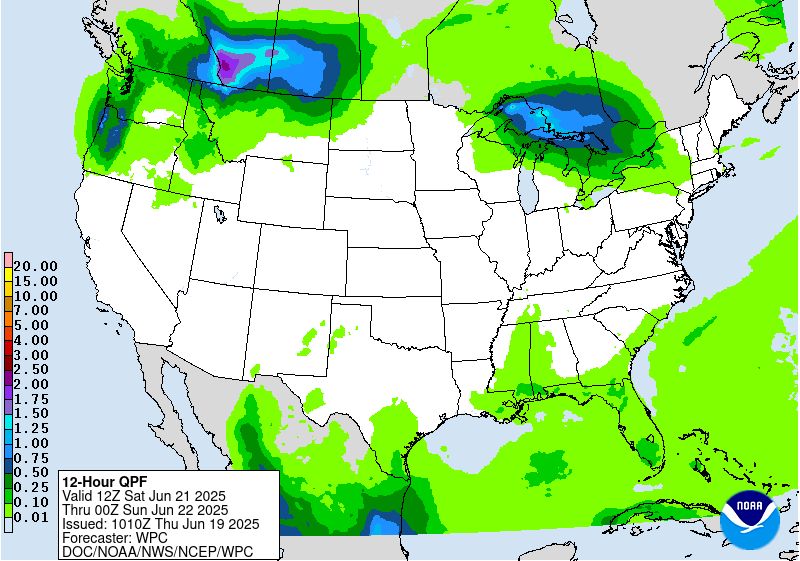
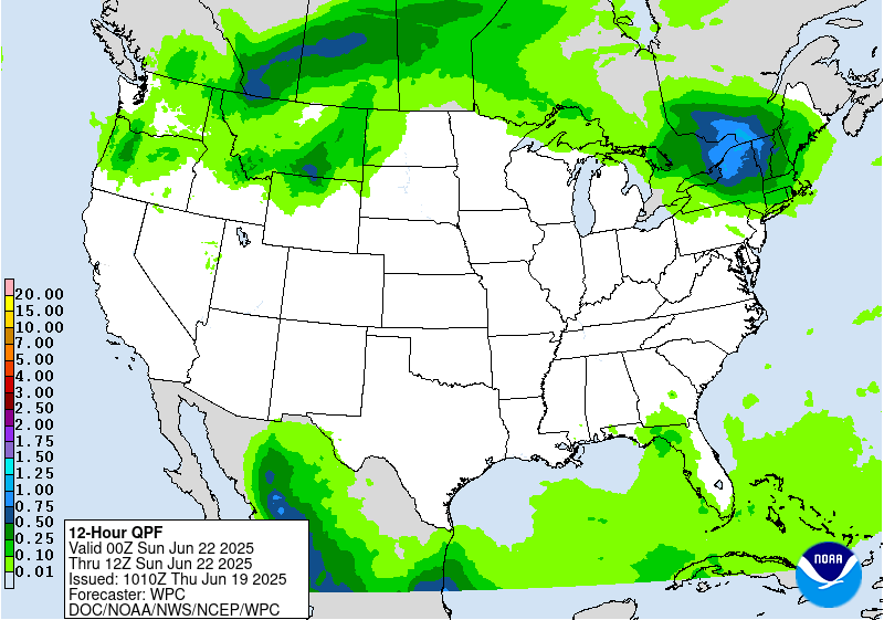
Valid 12Z Sat Jun 21 2025 - 12Z Sun Jun 22 2025
...THERE IS A MARGINAL RISK OF EXCESSIVE RAINFALL FOR PORTIONS OF THE
NORTHERN GREAT LAKES, INTERIOR NORTHEAST, AND NORTHERN MONTANA...
...Northern Great Lakes into the Northeast...
Shortwave progression out of the Upper Midwest will ride along the
northern periphery of our expansive ridge as we move through
Saturday. Ensemble consensus pins the energy over the Northern
Great Lakes with remnant thunderstorms propagating through the
Michigan U.P. into adjacent Ontario with a break in convective
activity in the CONUS before the disturbance re-emerges over
Upstate NY and Northern New England. Some discrepancy on the
northern extent of the shortwave progression as the ECMWF bias is
further north with sights on Western ME and far northern VT/NH as
the impact points. Other guidance is suggesting a bit further south
into Upstate NY through Central New England with heavier precip
threats more likely into the central and northern Hudson Valley.
This is a period to monitor closely as flash flood impacts will be
tied to the progression of a fairly robust complex as it exits out
of Canada. QPF distribution is skewed towards heavier precip
located within North Country of NY state with some secondary maxima
over Northern New England down through the Adirondacks. Heavy rain
over the U.P. may be progressive enough to curb significant
impacts, but the eastern portion of the U.P. is the area of concern
with the vacating complex as it moves quickly through the region.
The MRGL risk inherited was adjusted slightly to account for the
uncertainty in the exact progression of the complex.
...Northern Montana...
Our potent mid-upper trough will meander over the Pacific Northwest
with a strong shortwave migrating out of the base of the trough,
eventually closing off right along the International Border to the
northeast of Glacier National. Surface low development in-of the
closed upper reflection should provide a narrow axis of convergence
just outside the eastern slopes of the Rockies generating a period
of heavy rainfall in the adjacent valleys to the east of the
mountains. Height falls across the region will be significant
creating favorable mid-level lapse rates within any convective
scheme along with ample moisture advection east of the terrain. The
threat is very much tied to the northern tier of MT where the
convergence pattern is greatest. The threat is less pronounced
further south and east comparatively, however some inference of a
few mid-level perturbations ejecting downstream over Northern WY
into Southern MT could provide a secondary area of focus for heavy
rainfall. For now, the main threat within the QPF distribution is
for locally heavy rainfall in that small zone of convergence under
the surface low formation near the border. Local 1-2" is forecast
in that area with some ensemble QPF output closer to 3" not too far
away into Canada. Targeted MRGL risk for that area east of the
terrain remains with little change from previous forecast.
Kleebauer
Day 3 threat area:
www.wpc.ncep.noaa.gov/qpf/99epoints.txt
Extended Forecast Discussion
NWS Weather Prediction Center College Park MD
300 AM EDT Thu Jun 19 2025
A major synoptic pattern change is in store this weekend and into
next week as an upper-level ridge amplifies over the
central/eastern U.S. and precipitation chances focus along the
periphery. A leading frontal system ahead of a deep- upper trough
over the western U.S. will become quasi-stationary northwest of the
ridge through the Midwest southwest through the central Plains.
Embedded energies in the upper flow with accompanying frontal waves
to follow look to trigger widespread convection in vicinity of the
boundary Monday-Thursday. Anomalously high moisture (2+ standard
deviations above the mean) will lead to multiple days of heavy
rainfall and flash flood potential, with a Slight Risk ERO
introduced for day 5 (Monday) centered on the Middle Missouri
Valley, and a broader Marginal Risk from the Upper Midwest
southwest through the central Plains. Some severe weather will be
possible as well. To the southwest, an influx of moisture from
Mexico, connected at least in part to tropical cyclone Erick in the
eastern Pacific, is forecast to bring an increasing chance of
enhanced rainfall into west Texas and the southern high
Plains/Rockies later this weekend and especially into Monday-
Wednesday as PWATs rise upwards of 2.5-3 standard deviations above
the mean. For this reason, portions of the southern Rockies/High
Plains have been included in a day 5 (Monday) Marginal Risk.
Elsewhere, daily showers and thunderstorms are also expected in
vicinity of the Gulf Coast as disturbances round the south side of
the ridge. Precipitation chances (including some very high
elevation snow) will linger through Monday for the northern Rockies
under the influence of the deep upper-trough.
The first significant heat wave of the season is expected to be
expanding in coverage from the central Plains/Midwest/Great Lakes
into the Ohio Valley/Mid-Atlantic/Northeast on Sunday thanks to an
anomalous upper-level high building overhead. Heat will intensify
for portions of the interior South as well. Widespread Major to
Extreme Heat Risk (levels 3 and 4/4) is forecast, indicating an
intensity and duration of heat that is extremely dangerous to
anyone without adequate cooling or hydration. Heat indices are
forecast to climb into the 100-110 degree range, with 110-115
possible for portions of the Upper Ohio Valley and eastern
Carolinas/southern Mid- Atlantic. In addition, muggy overnight lows
in the mid- to upper 70s will bring little overnight relief from
the heat. Numerous daily record high and minimum temperatures are
possible. Some locations from the central Plains into the Upper
Midwest will see some relief Monday-Tuesday as a cold front moves
into the region, and the focus for the most intense heat shifts
from the Midwest/Great Lakes into the Ohio Valley and Mid-Atlantic.
Highs will be cooler and below average by as much as 10-20 degrees
across portions of the Pacific Northwest, Great Basin, and
northern Rockies/High Plains this weekend with a deep-upper level
trough overhead. Temperatures will moderate closer to average
through early/mid next week.
Putnam


