Excessive Rainfall Discussion
NWS Weather Prediction Center College Park MD
432 AM EDT Sat May 17 2025
Day 1
Valid 12Z Sat May 17 2025 - 12Z Sun May 18 2025
...THERE IS A SLIGHT RISK OF EXCESSIVE RAINFALL ACROSS PORTIONS OF
NORTHERN NEW ENGLAND...
...Texas to Alabama...
Convection will likely develop across portions of central TX this
afternoon as increasing forcing overruns the dryline. Pretty
impressive thermodynamic environment, with upwards of 5000 j/kg of
CAPE forecast along and east of the dryline, along with substantial
deep layer shear. This will likely result in rather explosive
convective development this afternoon, and while not the strongest
large scale forcing, there is enough mid level vort energy and
upper jet dynamics to support scattered to perhaps numerous
convective coverage. Supercells are likely, with some upscale
growth into convective clusters probable. Given the CAPE/shear
profile, large hail is the main threat, although even with such a
robust CAPE profile the deep layer moisture is actually still
pretty good. Thus these cells will likely be capable of producing
some heavy rainfall rates over 2"/hr as well.
Limiting factor for flash flooding will be quick cell motions
(30-40 kt mean westerly flow) and the high FFG over the area.
However right moving supercell motions are closer to 15-20 kts)
and the various cell movement deviations we see in a supercell
environment will likely lead to some cell mergers as well. Thus do
think we will see isolated flash flooding, with a focus over
central to northeast TX. Not sure we will get the FFG exceedance
coverage needed for a Slight risk given the generally quick cell
motions and high FFG, so we will stick with a Marginal risk. Even
the 00z RRFS, which tends to run hot with QPF rates/totals, only
depicts isolated hourly FFG exceedance.
Convection will likely be ongoing this morning across the eastern
portion of the Marginal risk (MS/AL), but should be in a decaying
state. However we could see at least isolated redevelopment along
the leftover outflow/front this afternoon, and anything that does
develop would likely be slow moving and capable of resulting in a
localized flash flood threat.
The Marginal risk was also expanded to the north into more of OK/AR,
southeast KS and southern MO. There are indications that an
overnight cluster of storms should develop here later tonight into
Sunday morning. This is where the stronger moisture convergence and
instability gradient should be and thus it makes sense that we
would get some elevated convection develop somewhere along this
axis. The 00z HREF is not that aggressive with development here,
but the HREF members can often be slow in catching on to training
elevated convective development. There is enough of a signal in the
00z global guidance to suggest we may see the HREF trend wetter on
future cycles, and there is at least some threat of an isolated
flash flood risk.
...Northeast...
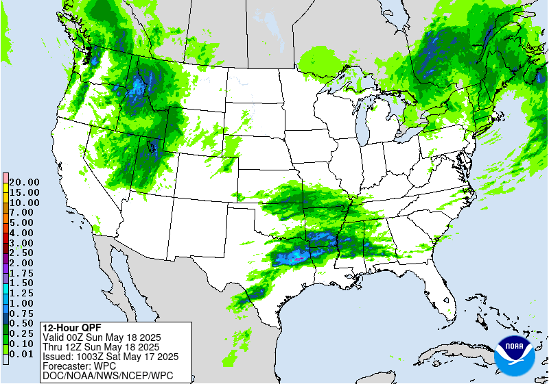
Multiple rounds of convection are expected across the Northeast
today into this evening. PWs and instability in place support high
rainfall rates, and both the 00z HREF and 18z REFS depict a 30-50%
chance of hourly rainfall over 1" and the 06z HRRR has a swath of
1- 2" per hour rainfall. In general, quick cell motions will help
limit the duration of these heavy rates, but the combination of
multiple convective rounds and high rates indicates at least some
flash flood risk is in place. Recent high res model runs indicate a
stationary/warm front in place over portions of VT/NH this
afternoon, which may act as a focus for some short duration
training of cells. Expect the best chance for isolated to scattered
flash flooding to focus near and south of this boundary, which
ends up encompassing much of central/northern VT into central NH.
This is generally a bit south and west of the inherited Slight
risk area. Thus we will expand the Slight risk into this region,
while maintaining it in northern NH and western ME (less confidence
on higher rates in these latter areas, but heavy rainfall over the
past 24 hours may keep the area a bit more sensitive to additional
rainfall today).
Chenard
Day 1 threat area:
www.wpc.ncep.noaa.gov/qpf/94epoints.txt
Excessive Rainfall Discussion
NWS Weather Prediction Center College Park MD
432 AM EDT Sat May 17 2025
Day 2
Valid 12Z Sun May 18 2025 - 12Z Mon May 19 2025
...THERE IS SLIGHT RISK OF EXCESSIVE RAINFALL ACROSS PORTIONS OF THE
CENTRAL PLAINS INTO THE LOWER AND MIDDLE MISSISSIPPI VALLEY...
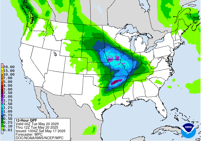
...Plains, MS Valley and Southeast...
A favorable pattern for widespread convection and heavy rainfall
on Sunday across the middle portion of the country. A longwave
trough and embedded shortwaves pushing eastward across the Rockies
and into the Plains will provide ascent over a broad region. The
frontal pattern will likely feature a developing low moving into
the High Plains of CO/NE, a warm or stationary front extending east
of this low across portions of OK/KS into MO/AR, and a dryline
across OK/TX. A large pool of instability is expected east of the
dryline and south of the stationary front, with values upwards of
4000-5000 j/kg. Some convection may be ongoing near the
warm/stationary front Sunday morning, but more robust development
is expected by Sunday afternoon into the overnight hours as
stronger forcing ejects into the Plains.
The main area of focus for flash flooding appears to be near the
aforementioned warm/stationary front where some training of convection
is probable. The overall expectation is that robust convective
development occurs along/ahead of the dryline over central OK/KS
during the afternoon hours. Strong deep layer southwesterly flow
will likely quickly push this activity northeastward towards the
warm/stationary front. Activity will likely grow upscale Sunday
evening into the overnight, potentially into an MCS, at which point
it should feel the impact of the strong southwesterly low level jet
and begin turning easterly and then southeasterly aligned with the
upwind Corfidi Vectors. As this process occurs some
training/backbuilding on the south/southwest extent is probable
resulting in a scattered flash flood threat.
The exact MCS location/track remains a bit uncertain. All but
certain that the 00z NAM is too far north, as its QPF evolution is
an outlier and does not align with pattern recognition. The GFS
and GEFS mean are also probably too far to the northeast, with the
aforementioned expected MCS propagation taking it on a farther
south track. The 00z Gem Reg and RRFS are very far south, tracking
across eastern OK into central/northern AR. This may be too far
south, but can not be ruled out as easily as the farther north NAM
can. The AIFS has a track record of pinpointing organized
convection location quite well, and the 00z AIFS favors northeast
OK into southeast KS and southwest MO. This also happens to
generally be the middle ground of the other available models, and
so does appear to represent the most likely outcome at this time.
Thus a higher end Slight risk will remain in place across this
corridor, where scattered flash flooding is expected. The Slight
risk area was cut back a bit on its northern extent and expanded
to the southwest into more of OK and AR to account for the southern
trend. Can not rule out additional southward shifts/expansion..but
for now think the Slight risk area represents the general region
of most concern well.
Another area of interest will be farther northwest into central and
western NE, closer to the low track. A multi-model signal exists
for a second QPF max over this area...which makes sense given what
should be impressive synoptic driven ascent and instability along
the stationary/occluded front. Considered expanding the Slight risk
into this area...but opted against that for now. This area remains
in severe to extreme drought and possible the rainfall max ends up
over the high FFG sand hills. But we will continue to monitor
trends and an additional focused Slight risk may eventually be
needed.
A localized flash flood risk also exists both along the dryline from
central TX into OK...and over the Southeast where a lingering
boundary and substantial instability will support heavy rainfall
with any storms that area able to develop.
...Northeast...
A Marginal risk continues over portions of northern New England on
Sunday as a deep layered low remains overhead. This will be the
3rd straight day of localized heavy rainfall, and thus some areas
may be more sensitive by this time. Generally thinking both
instability and moisture will be lower by Sunday, however cold air
aloft under the low will likely still support some heavier
convective cells and an isolated flash flood risk.
Chenard
Day 2 threat area:
www.wpc.ncep.noaa.gov/qpf/98epoints.txt
Excessive Rainfall Discussion
NWS Weather Prediction Center College Park MD
432 AM EDT Sat May 17 2025
Day 3
Valid 12Z Mon May 19 2025 - 12Z Tue May 20 2025
...THERE IS SLIGHT RISK OF EXCESSIVE RAINFALL ACROSS PORTIONS OF THE
CENTRAL PLAINS INTO THE LOWER AND MIDDLE MISSISSIPPI VALLEY...
Another day of widespread heavy rainfall expected across the middle
portion of the country on Monday as the longwave trough and embedded
shortwave energy slowly moves eastward. It will likely be an active
day/night with a broad region where flash flooding will be possible.
A Slight risk stretches from northeast TX northward into southern IA.
The northern extent of the Slight risk will be close to or just
north of the stationary front extending east of the central Plains
low pressure. Strong forcing overrunning this boundary will likely
result in an expansive area of convection, with some
training/backbuilding possible. The southern portion of the Slight
risk is driven by initial dryline convective development, likely
enhanced by the eventual eastward acceleration of the cold front
south of the low. The convergence from the dryline, cold front and
lifting warm front will all aid in convective development. The
general stagnant nature of the frontal feature through much of the
day (both the warm/stationary front and dryline) support a
training/backbuilding convective threat.
Exactly where the focus of highest QPF ends up remains a bit of a
question, but generally anywhere within the Slight risk is in play.
There is some signal that the axis from northeast TX into southern
MO could actually see the most intense rates and greatest flash
flood potential, with both the 00z CMC and AIFS highlighting this
corridor. However ingredients will also be quite favorable farther
north into MO and southern IA as well (pending exact frontal
positioning) and thus both of these areas could end up seeing
training/backbuilding at some point Monday and/or Monday night.
Some of these areas will also likely see heavy rain on day 2 as
well, and so hydrologic conditions could be more sensitive by this
day 3 time frame. Thus do consider just about all of the Slight
risk as a higher end Slight at this time, and think areas of flash
flooding are likely. It seems possible (maybe even probable) that
an embedded MDT risk will eventually be needed somewhere within
the broad Slight risk area. However uncertainty in both the
convective details and hydrologic conditions (pending what rainfall
happens on day 1 and 2) leads to low confidence in any MDT risk
location at this time. Thus we will hold with a higher end Slight
and continue to monitor trends.
Chenard
Day 3 threat area:
www.wpc.ncep.noaa.gov/qpf/99epoints.txt
Extended Forecast Discussion
NWS Weather Prediction Center College Park MD
300 AM EDT Sat May 17 2025
The notable surface low pressure system over the Middle
Mississippi Valley Tuesday will draw in above average moisture
(with precipitable water values nearing the 90th percentile for
this time of year) and ample instability ahead of its associated
cold front. The upper low spinning aloft will provide good
dynamical lift, and this combination of ingredients will lead to
widespread rain and thunderstorms and mesoscale convective systems,
with best chances slowly progressing east from the central to
east-central to eastern U.S. as next week progresses. The greatest
chance for heavy rain causing flash flooding should be across the
Mid-Mississippi and Ohio Valleys into the central Appalachians on
Tuesday, as moisture and instability pool near a warm front
stretching west-east that could promote training storms. A
relatively expansive Slight Risk is in place in the Day 4/Tuesday
ERO. Severe weather is also possible per the Storm Prediction
Center, as they show a severe area centered over the Lower/Middle
Mississippi Valley on Tuesday. Rain and thunderstorm potential
should press toward the Eastern Seaboard by midweek as the low
tracks east. Locally heavy rainfall is possible particularly for
the Mid-Atlantic region on Wednesday. The Day 5/Wednesday ERO
indicates a Marginal Risk for flooding potential. A future Slight
Risk is not out of the question, but prefer to wait on better model
agreement for the low track and timing and thus the placement of
the highest QPF. Soils/streamflows are currently wet but should
have a few days of drying before midweek. Rain chances will make
their way into the Northeast Thursday-Friday as the surface low
pivots northward.
Elsewhere, some weak troughing aloft and frontal systems tracking
through the Northwest next week could produce rounds of modest
precipitation there. Most precipitation should be rain aside from
the highest peaks. Some rain may eject into the northern High
Plains by Thursday, with possibly another round of storms emerging
in the central U.S. by Friday, but with quite a bit of uncertainty.
Warm to hot temperatures are likely across the southeastern U.S.
as the subtropical upper ridge reaches the region. Southern Texas
in particular will remain hot into Tuesday, with temperatures well
into the 100s leading to Major HeatRisk through Tuesday. The
Florida Peninsula should see warm temperatures in the mid 90s. Both
areas could see record or near record warm lows and highs.
Meanwhile the trough aloft will promote below normal temperatures
across the northern tier, with highs only reaching the 50s in the
north-central Plains on Tuesday. As the trough tracks east and its
influence deepens, cooler than average temperatures are likely in
the eastern third of the U.S. under it, and this will also moderate
the temperatures in the South. But upper ridging poking into the
southwestern U.S. will raise temperatures to above normal there,
expanding east across the Four Corners states by Thursday and into
the southern Plains late next week. Highs will be well into the
100s in the Desert Southwest with temperatures nearing 100 in parts
of Texas eventually.
Tate


