Excessive Rainfall Discussion
NWS Weather Prediction Center College Park MD
530 PM EDT Thu May 29 2025
Day 1
Valid 2124Z Fri May 30 2025 - 12Z Fri May 30 2025
...THERE IS A SLIGHT RISK OF EXCESSIVE RAINFALL FOR PORTIONS OF
CENTRAL TEXAS...
21z Update:
A Slight risk was added to much of central TX with this update.
Convection should expand in coverage and grow upscale into an MCS
or convective cluster or two tonight. Generally looking like a
forward propagating convective system, which should limit the
extent/magnitude of flash flooding. However a few cell mergers and
high rainfall rates should be enough for isolated to scattered FFG
exceedance. This evolution is supported by both the latest HREF and
REFS ensemble systems, as well as recent runs of the HRRR and RRFS.
Both the HREF and REFS show neighborhood probabilities of exceeding
3" in the 40-60% range over much of the Slight risk area...with
much of this rain falling in just an hour or two. These rainfall
rates should be high enough to produce isolated to scattered flash
flooding...especially over an more sensitive urban or low lying
areas.
Chenard
...16Z Update...
Some reshuffling of the large Marginal Risk across a large section
of the country was done with this update. The inherited Marginal
was removed from the Texas Gulf Coast and most of Louisiana and
Mississippi with this update, as the area behind the ongoing
convection tracking along the Gulf Coast should stay dry and
relatively storm-free this afternoon with northerly flow hampering
the moisture in this area somewhat. There is also good signal among
the CAMs for a minimum of precipitation in this area through 12Z.
However, the Marginal was expanded to include much of the southern
Appalachians and much of the Florida Peninsula with this update;
both for the same reason. Afternoon convection is likely to develop
in these areas, which while unlikely to organize, could be slow-
moving, tied to the sea breeze in FL, or the terrain in the Apps,
which could lead to a localized prolonged period of heavy rain.
Some sensitivity to flooding in these areas from moist soils would
also support an isolated flash flooding threat.
Wegman
...Previous Discussion...
...Mid Mississippi and Ohio Valleys...
A shortwave currently analyzed across the Central Plains will
continue to progress eastward overnight under the base of a broad
ULL situated over the Midwest. Increased mid and upper forcing will
aid in scattered convection through the course of the period in the
area spanning from Eastern KS through the Central Ohio Valley.
Some of the stronger convective cores will be capable of locally
enhanced rainfall rates between 1-2"/hr at peak intensity leading
to isolated flash flood prospects in-of the above zone. The
positive news in the setup is the moisture anomalies across the
region of interest remain near to just slightly above normal with
NAEFS anomalies signaling less than +1 deviation for the area.
This will limit the upper threshold of flood concerns for the
setup, but some of the heavier cores could still cause some flash
flood concerns within more urbanized settings and over some of the
terrain focused areas of Southern MO, as well as Eastern KY/TN. The
previous MRGL risk was generally maintained with only some minor
adjustments on the northern periphery of the risk area.
...Southeast U.S...
A shortwave trough over the Southern Plains will roll eastward
overnight and through the period with focused ascent within the
confines of the Southeastern U.S. Weak jet coupling from a vacating
jet over the Tennessee Valley and approaching jet from the west
will create a period of stronger forcing in-of the Central Gulf
Coast early this morning with convective activity rooted in a
narrow corridor of elevated theta_E's stemming from southerly flow
near the coast. Expectation is for scattered heavy convection to
initiate across Southern LA and migrate eastward with the stronger
forcing advancing across the Southeast. Scattered thunderstorms
will be found across off the Southeast by late-morning and beyond,
but the progressive nature of the threat should limit the chances
for widespread flash flooding. QPF mean between 1-2" is forecast
along the Central Gulf Coast with some deterministic maxima between
4-5" showing up within the 00z CAMs. This put modest (30-50%) HREF
neighborhood probs for >3" within that zone between New Orleans to
Mobile, but even still that signature is not going to be enough to
move the needle outside a MRGL threat. A cold front will sweep
through the region from northwest to southeast leading to a sharp
shift in the environmental moisture availability and limiting
instability region-wide. This will ultimately end the threat for
any convection and put an end to any risk in place. For now, the
MRGL risk remains across the Southeastern U.S. with emphasis on the
Central Gulf Coast for best threat in the period.
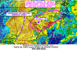
Further east over Southeastern SC, another round of strong
thunderstorms will likely occur late-afternoon with the best flash
flood risk likely within more urban zones like Charleston and small
areas like Hilton Head. This actually the zone with the highest >3"
probs in the country, but again, the threat is very localized for
flash flood concerns considering the sandier soils prompting higher
FFG's. In this case, the threat will continue to be more in-line
with a MRGL risk leading to general maintenance of the previous
forecast.
...Southern Plains...
Increased ascent within the confines of a cold front pressing south
through the Southern Plains will lead to a corridor of heavy
rainfall developing upstream across the Caprock, moving southeast
within the mean flow and expected upwind trajectory of any cold
pool generation. Regional instability parameters point to a
sufficiently buoyant environment along and ahead of the advancing
cold front leading to a suitable MCS maintenance regime that will
begin over Eastern NM and eventually work its way southeast through
the rest of the Texas Caprock, Permian Basin, and Concho Valley by
nightfall. HREF EAS probs for >1" are modest (20-40%) for the
probability scheme, but a stronger neighborhood prob for >2"
(50-80%) exists over that area referenced above. Progressive nature
of the eventual complex should curb some of the threat, but
scattered instances of flash flooding will be plausible where the
MCS migrates overhead. The highest threat will likely be within
more urban settings and over the Concho Valley where 3-hr FFG
exceedance probs are highest (30-40%) due to antecedent soil
moisture.
Kleebauer
Day 1 threat area:
www.wpc.ncep.noaa.gov/qpf/94epoints.txt
Excessive Rainfall Discussion
NWS Weather Prediction Center College Park MD
530 PM EDT Thu May 29 2025
Day 2
Valid 12Z Fri May 30 2025 - 12Z Sat May 31 2025
...THERE IS A SLIGHT RISK OF EXCESSIVE RAINFALL FOR PORTIONS OF
THE OHIO VALLEY AND MID ATLANTIC...
...20Z Update...
Continued increases in the forecast rainfall from the 12Z guidance
suite, sufficient instability for storms, ample upper level
forcing from a strong shortwave that rapidly turns negatively
tilted, and soil sensitivity due to recent heavy rainfall have all
worked to increase the concern for flash flooding across portions
of the Ohio Valley and Mid-Atlantic Friday and Friday night.
Generally, the convection will track from west to east...so the
portion of the Slight in Kentucky really focuses on Friday morning,
whereas the portion in northern New Jersey is primarily focused on
after midnight Friday night.
Soil sensitivity to flash flooding is high as soil moisture levels
remain well above the normal for this time of year due to rain as
recently as yesterday, and not including any shower and isolated
thunderstorm activity probable around the DMV region the afternoon
and this evening. Further, possible repeating rounds of heavy rain
on Friday interacting with the terrain and full rivers should cause
onset of flash flooding to occur sooner...closer to the rainfall
start time...in these areas, making any potential flooding more
hazardous in West Virginia. Further east, urban concerns will
increase the potential impacts from flash flooding. The storms will
also occur in the afternoon and evening, during the diurnal warmest
time of day, which will add more instability for the storms to feed
on. Given all of the above, have introduced a higher end Slight
from eastern Kentucky to the Baltimore metro. The 12Z HREF suite
shows an over 50% chance of exceeding 6-hour FFGs across the DMV.
The Slight Risk area was expanded northeast across the Philadelphia
Metro and much of northern New Jersey with this update. While the
storms will impact this region Friday evening and into the
overnight, here too recent heavy rainfall will make flash flooding
more common compared to if the soils were dry. By Friday evening
a coastal low will be rapidly forming, and so instability will be
waning as the precipitation shield evolves into more of a comma
shape, with the heaviest rains along the Delaware River on the
cold/more stable side of the low. Nevertheless, remnant instability
and long duration of rainfall will still cause widely scattered
instances of flash flooding. Since the low will have a comma-shape
Friday night, the dry slot will end the rainfall sooner in some
areas. While there is some uncertainty where it will be, it looks
to focus along the Jersey Shore. Thus the Slight was kept from the
coast a bit expecting the rain to end there sooner than areas along
the Delaware River.
The surrounding Marginal Risk was also expanded into NYC and southern
New England for Friday night. Here too the dry slot could limit
rainfall amounts, especially the further east you go. Upslope into
the terrain of Connecticut and recent rains around NYC could still
cause locally heavy rain before the dry slot moves in.
Wegman
...Previous Discussion...
A potent upper trough will slowly pivot eastward while taking on a
more neutral tilt as it swings through the Great Lakes and Ohio
Valley on Friday. At the surface, low pressure will develop within
the middle of an evolving jet couplet in-of the eastern portion of
the Ohio Valley with deterministic output placing the low nearby
Eastern KY. The entire dynamic between sfc-500mb will play an
integral role in the potential for heavy rainfall in areas of KY/WV
the first half of the period, shifting eastward through the
Shenandoah of VA by the afternoon and evening Friday before
providing quite the convective posture over the DMV and points
northeast. 00z suite has come in much more aggressive in the
presentation of heavy rainfall across the above areas with a dual
maxima signature present within the ensemble means. The first max
is over Eastern KY into Southern WV thanks to intense large scale
ascent being driven by a powerful shortwave rotating into the
region along the base of the mean trough as it approaches the
region. At the surface, a narrow tongue of surface based
instability will be co-located within the mid and upper level
ascent max being delivered by the trough, a product of a warm front
lifting north ahead of the aforementioned surface low off to the
west. A line of thunderstorm activity will likely transpire within
proxy of the warm front leading to enhanced rainfall rates likely
to spur totals between 1.5-3" with potentially higher over a span
of 3-6 hrs. before a cold front sweeps through the area in wake of
the lows progression to the east-northeast.
Current FFG exceedance probs for both 3 and 6hr increments are
pretty robust (>50%) within the corridor referenced above, along
with some hourly rate exceedance probs between 50-80% between the
12-18z time frame on Friday. The signature typically correlates to
a better than average threat for flash flooding, especially when
you account for the antecedent soil moisture and the complex
topography situated over Eastern KY and Southern WV. This allowed
for an addition of a SLGT risk across these two areas.
Further east, soil moisture anomalies will remain elevated thanks
to a barrage of rainfall the past 24 hrs. and very wet conditions
overall the past 2 weeks. As the surface low matures on its trek to
the east and the trough begins a more negative tilt to the west,
expectation is the for the low to begin intensifying steadily with
a sharper deformation axis beginning to take shape across the
Central Mid Atlantic. Heavy rains on the western flank of the low
will likely occur across the Northern and Central Shenandoah, an
area that has been hit hard over the course of May and is already
experiencing relatively higher stream flows. Current HREF depiction
for 6hr exceedance probs over Northwestern VA are between 50-80%
over the Blue Ridge and adjacent valley areas from Harrisonburg to
just north of Winchester. A smaller max is co-located with the more
urban centers of Northern VA towards the DC metro, but that is at
the end of the hi-res temporal window. The assessment of the final
6 hr period from the CAMs and the global deterministic and ensemble
outputs in the final 12 hr time frame indicate a mass of heavy
rainfall being depicted within the MD Piedmont to the Chesapeake.
NAM Nest is incredibly bullish in its interpretation, likely due to
the strong low to mid-level lapse rate signature across the area
looking at forecast soundings, as well as persistent 250-750 J/kg
MUCAPE still present prior to the cold front arrival. QPF output is
around 1-2" currently for the DC/Balt Metro and surrounds for the
period, a signal strong enough to warrant a targeted upgrade in the
forecast risk. As a result and with coordination from the local
Sterling, VA WFO, a SLGT risk was issued for the period across the
above area.
Heavy rainfall will occur further north as the low matures, but the
instability gradient is fairly tight on the northwest periphery of
the low as we move closer to Saturday morning. It's plausible
places like Philadelphia and areas of Southern NJ and Southeast PA
could see a targeted upgrade as well for the D2, but the signal is
more borderline for those locales. The MRGL risk was maintained for
those areas up to Northern NJ, but will be something to monitor as
we move closer.
Kleebauer
Day 2 threat area:
www.wpc.ncep.noaa.gov/qpf/98epoints.txt
Excessive Rainfall Discussion
NWS Weather Prediction Center College Park MD
530 PM EDT Thu May 29 2025
Day 3
Valid 12Z Sat May 31 2025 - 12Z Sun Jun 01 2025
...THERE IS A MARGINAL RISK OF EXCESSIVE RAINFALL ACROSS PORTIONS
OF NORTHERN NEW ENGLAND...
...20Z Update...
Very few changes were needed to the inherited Marginal Risk, with
maybe a small southward adjustment across Massachusetts, where
rainfall occurring just before the start of the period 12Z Saturday
will be ongoing into the start of the D3 period. The surface low
will be well-formed by 12Z Saturday, with surface pressures
dropping into the 980 mb range. However, instability will be
lacking as New England is on the "cold" side of the low...so almost
all of the rainfall will be stratiform. Terrain interactions will
locally increase rainfall rates, so the Marginal, while low-end and
low-confidence, remains in place.
Wegman
...Previous Discussion...
Powerful surface low across the Mid Atlantic on D2 will motion to
the northeast, eventually dropping down into the 980s as it
occludes and drifts north over New England. Residual heavy rains
will occur across parts of Northern New England with the heaviest
rainfall likely over Northern NH and ME, especially within the
northeastern flank of the low where WCB process will advect deeper
moisture poleward with weak buoyancy likely remaining over the
region during the first 12 hrs of the D3 period. Totals of 1-2"
with locally higher are forecast over the above zones leading to
localized flash flood potential given the complexity of the terrain
impacted and relatively good dynamics at play.
The MRGL risk inherited was only adjusted on the western half of
the risk as trends have pushed the heavier rain a little further
east compared to previous forecasts. The area over Central and
Western ME is the most susceptible in this pattern with potentially
greater impact into Southern New England if the low slows down and
brings a stronger convective output towards Eastern MA and RI the
front end of D3. Will be an area to assess closely in the coming
updates, but maintained the nil there for now.
Kleebauer
Day 3 threat area:
www.wpc.ncep.noaa.gov/qpf/99epoints.txt
Extended Forecast Discussion
NWS Weather Prediction Center College Park MD
232 PM EDT Thu May 29 2025
A series of shortwaves will continue to dig into an amplified
upper trough working slowly off the East Coast and potentially
developing a separated closed low. A wavy trailing front will
settle nearby from the western Atlantic southwestward to the Gulf.
While uncertain lows could act to bring some activity from the
coastal areas up the Eastern Seaboard Sunday and into next week,
particular runoff issues may develop with time for south Florida
urban areas given deeper lower latitude moisture availability and
support to monitor.
Guidance continues to overall favor upper trough amplification
with multiple systems into the West along with lead ejection of a
southern stream closed system from offshore Baja through the
Southwest into the Rockies. This transition will act to provide
relief from weekend heat over portions of the West with the
building of a much more unsettled and increasingly wet flow pattern
farther inland and downstream over the Intermountain West and
especially the northern Rockies through midweek. Despite the
calendar flipping into June, this pattern will support a threat for
enhanced mountain snow in the highest elevations of the northern
Rockies. Favorable upper support, frontal translation, and
anomalous moisture along with downstream cyclo-/frontogenesis over
the Plains should also act to enhance precipitation and an emerging
convective pattern from portions of the northern Rockies to the
northern Plains by Day 5/Monday. Despite guidance shifting around a
bit, increasing convective/QPF trends support the introduction of
a broad Marginal Risk ERO from portions of Minnesota and the
Dakotas to southeast Wyoming and northeast Colorado with this
afternoon's update.
Miller/Schichtel


