Excessive Rainfall Discussion
NWS Weather Prediction Center College Park MD
1159 AM EDT Fri May 30 2025
Day 1
Valid 16Z Fri May 30 2025 - 12Z Sat May 31 2025
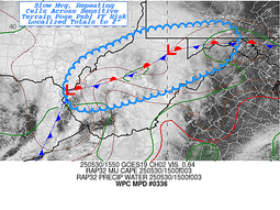
...THERE IS A SLIGHT RISK OF EXCESSIVE RAINFALL FOR PORTIONS OF THE
OHIO VALLEY THROUGH THE MID-ATLANTIC STATES...
The regional satellite imagery this morning shows a potent upper
low moving across Ohio, and it is this feature which will help
manifest the flash flood risk from the Ohio Valley into the Mid-
Atlantic and Northeast today. As this low tracks northeast today,
it will move along a baroclinic zone/surface front, helping to
spawn a surface wave of low pressure. This low will track E/NE
along the boundary, moving from eastern KY this morning to western
New England by Saturday morning.
As this low tracks northeast, it will encounter increasingly
favorable thermodynamics, into which forcing will become more
intense, leading to both an expansion and intensification of
convection. The simulated reflectivity from the available CAMs are
relatively similar with widespread showers and thunderstorms
blossoming ahead of the low, and becoming most impressive from
Maryland and points northeast into western New England. This is
supported by more robust thermodynamics being drawn northward,
characterized by a ribbon of elevated PWs of 1.25 to 1.5 inches,
highest east of I-95, and MUCAPE above 1000 J/kg. This will support
rainfall rates for which the HREF indicates have a high a moderate
to high chance (40-70%) of exceeding 1"/hr, and 10-20% chance of
exceeding 2"/hr, enhanced by increasingly impressive synoptic
ascent aided by the LLJ and favorable LFQ of a strengthening jet
streak.
In general, convection which develops downstream of the low will
be progressive on 0-6km mean winds of 20-30 kts. However, aligned
Corfidi vectors suggest some short-term training is possible which
could lengthen these rain rates, or result in repeating rounds in
some areas. Additionally, as bulk shear surges to 40-50 kts,
storms will likely organize into clusters, with an even better
chance for some training along I-95 from Washington, D.C. into
western New England. The simulated reflectivity suggests as the
surface low wraps up a dry slot will pivot in behind the primary
clusters, somewhat reducing the excessive rain risk, but this is
lower confidence, and a stripe of heavy rain of 1-3" is expected,
with locally more than 4" (or even 5") possible from Maryland
through New York as reflected by both the NBMv5.0 and the HREF. The
inherited SLGT risk was modified only slightly for recent
guidance, and expanded a bit northeast into New England.
Weiss
Day 1 threat area:
www.wpc.ncep.noaa.gov/qpf/94epoints.txt
Excessive Rainfall Discussion
NWS Weather Prediction Center College Park MD
1159 AM EDT Fri May 30 2025
Day 2
Valid 12Z Sat May 31 2025 - 12Z Sun Jun 01 2025
...THERE IS A MARGINAL RISK OF EXCESSIVE RAINFALL OVER PORTIONS OF
NEW ENGLAND...
A surface low pressure system across the Mid Atlantic on Friday
will continue to strengthen as it makes its way to the northeast on
Saturday. Concern for heavy rains lingers across parts of New
England with the heaviest rainfall likely over Northern NH and ME,
especially within the northeastern flank of the low where the warm
conveyor belt advects deeper moisture poleward with weak buoyancy
likely remaining over the region into Saturday evening. Additional
rainfall amounts of 1 to 2 inches...with locally higher
amounts...remain in the forecast. That amount of rain could lead to localized
flash flooding given the complex terrain impacted and relatively
good dynamics at play.
Bann
Day 2 threat area:
www.wpc.ncep.noaa.gov/qpf/98epoints.txt
Excessive Rainfall Discussion
NWS Weather Prediction Center College Park MD
1159 AM EDT Fri May 30 2025
Day 3
Valid 12Z Sun Jun 01 2025 - 12Z Mon Jun 02 2025
...THERE IS A MARGINAL RISK OF EXCESSIVE RAINFALL OVER PORTIONS OF
THE SOUTHWEST UNITED STATES...
Showers and thunderstorms will become more numerous over parts of
the Southwest US as a plume of moisture overspreads the region
from the south...with the anomalous moist airmass allowing some of
the storms to produce locally heavy rainfall and the risk of flash
flooding. Precipitable water values of an inch or greater should
already be in place across southwest Arizona and adjacent areas of
the California deserts at the start of the Day 3 period...90+
percentile values for this time of year...with moisture continuing
to stream into the region. With the flow aloft becoming
increasingly diffluent to the east of closed low off the California
coast at the same time that moisture continues to stream into the
region...storms should be in an environment conducive for heavy
rainfall and the potential for repeat convection/training storms
leading to the risk of flash flooding. One concern is the
increasing moisture may result in sufficient cloud cover to delay
or inhibit the convective initiation...but there is enough support
in the guidance to support a Marginal risk at this time frame.
Bann
Day 3 threat area:
www.wpc.ncep.noaa.gov/qpf/99epoints.txt
Extended Forecast Discussion
NWS Weather Prediction Center College Park MD
249 AM EDT Fri May 30 2025
As an amplified upper trough tracks slowly off the East Coast a
series of shortwaves will dig through the flow; which may
potentially develop into a separated closed low. A wavy trailing
front will settle nearby from the western Atlantic southwestward to
the Gulf. While uncertain lows could act to bring some activity
from the coastal areas up the Eastern Seaboard Sunday and into next
week, particular runoff issues may develop with time for south
Florida urban areas given deeper lower latitude moisture
availability and support to monitor.
While differences on the details persist with time, the general
consensus favors upper trough amplification with multiple systems
into the West along with lead ejection of a southern stream closed
system from offshore Baja through the Southwest into the Rockies.
This pattern change will be a welcomed relief to recent heat across
the West as well as transitioning to a more unsettled and
increasingly wet flow pattern farther inland and downstream over
the Intermountain West and especially the Northern Rockies through
midweek. This will support the possibility for enhanced mountain
snow in the highest elevations of the Northern Rockies. Favorable
upper support, frontal translation, and anomalous moisture along
with downstream cycle-/frontogenesis over the Plains should also
act to enhance precipitation and an emerging convective pattern
from portions of the Northern Rockies to the Northern Plains by
the start of the new week. Maintained the broad Marginal Risk for
the Day 4 ERO from portions of Minnesota, the Dakotas, eastern
Wyoming and northeast Colorado. A broad Marginal Risk was
introduced for the day 5 period as the precipitation advances over
the central part of the country and encompasses the eastern
Dakotas, Minnesota, western Wisconsin, Iowa, eastern Nebraska,
Kansas, western missouri and northeast Oklahoma.
Campbell/Miller/Schichtel


