Excessive Rainfall Discussion
NWS Weather Prediction Center College Park MD
402 PM EDT Thu Jun 12 2025
Day 1
Valid 16Z Thu Jun 12 2025 - 12Z Fri Jun 13 2025
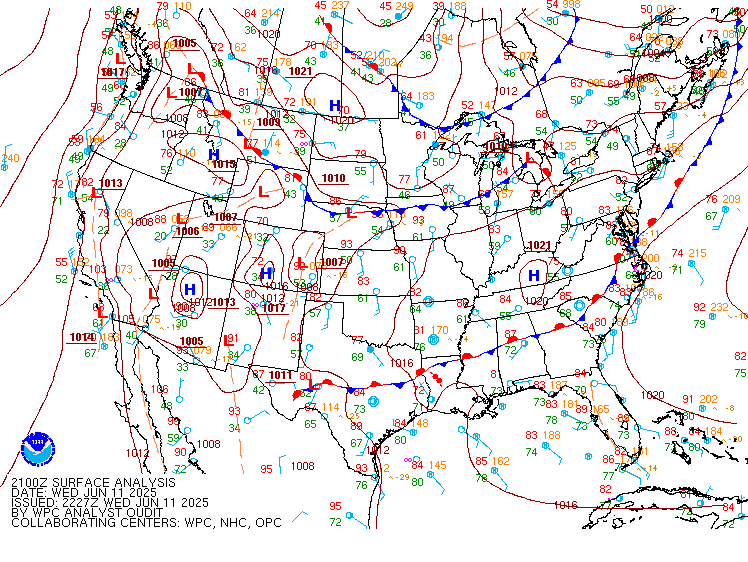
...THERE IS A MODERATE RISK OF EXCESSIVE RAINFALL FOR PORTIONS OF
SOUTHEAST TEXAS...
...Texas through Arkansas...
16Z Update: The general expectation for the MDT risk inherited has
come to fruition this morning leading to only necessitating a
formal "trimming away" of areas that have already been impacted and
will see no additional threats this period. The MDT risk is now
more confined to the middle and upper TX coasts with a minor
expansion to the northeast to include the Beaumont area. MUCAPE
gradient is well-documented within both the latest Mesoanalysis and
the derived GOES-East satellite parameter. Values between
1000-2000 J/kg are still situated within the confines of the MCS
over the middle TX coast with a 2000-3000 J/kg signature still
aligned upwind of the flanking line extending back inland. Cloud
streaks moving northward across Deep South TX depict a sufficient
moisture advection pattern continuing across the region and will
play a role in the convective maintenance through the next 2-4
hrs. The good news is the cold pool associated with the setup is
already starting to race out into the Gulf on the northern flank of
the complex with the back edge beginning to see some advancement
of the outflow ahead of the main line which will likely degrade the
convective pattern later this afternoon. As a result of the
evolution, a sharp delineation of the convective threat for the
rest of the period has materialized with a likely diffusion of the
heavier rain prospects between 18-21z as noted via 12z CAMs output.
4-8" with locally 10-15" of rainfall are plausible when the entire
event is done for areas southwest of Houston to back along the
flanking line. Rainfall rates of 2-4"/hr are possible within the
strongest convective cores over the next few hrs before the
degradation of the overall setup. Anticipating a removal of a lot
of the risk area across coastal TX back into the I-35 corridor
later as the threat wanes, so will be monitoring closely for that
specific adjustment.
Across Northeast TX into the ArkLaTex, MCV propagating to the
north-northeast has allowed for a narrow band of heavier rainfall
within the convergent sector of the low to mid-level circulation.
This will continue to press north over the next several hrs with
flares of additional heavier convective cores basically maintaining
precedence through the afternoon and early evening. 2-4" areal
average with totals as high as 5" are possible across the ArkLaTex
through Arkansas today as additional waves of convection will
propagate northward behind the vacating MCV leading to a
compounding effect of heavy rainfall on saturated soils. The best
chance for flash flooding will be within those urban zones and
areas that have received significant rainfall the past 24 hrs.
Considering the favorable output already, and the expectation as
depicted from CAMs, the SLGT risk with higher-end threshold is
still forecast over the above zones. A small expansion on the
northern periphery of the SLGT and MRGL risks was also made to
account for the latest HREF mean QPF signature and small adjustment
north of the better probs for greater than 2" and 3".
Kleebauer
..Previous Discussion..
In coordination with HGX/Houston, TX forecast office, a Moderate
Risk upgrade was introduced with this update. Convection blossoming
over central Texas right now is forming in response to increased
upper level divergence ahead of a sharp upper level trough over
west Texas. This trough is also supporting a potent LLJ advecting
deep tropical moisture out of the Gulf and into east Texas. This
steady supply of plentiful moisture along with a very slow-moving
upper level trough are both primary ingredients for slow-moving
thunderstorms capable of producing very heavy rainfall. Storm
coverage will continue to increase so that by the start of the
period later this morning, a well-defined MCS will have developed
north and west of Houston. The storms will build southeastward
towards the Gulf as they advect towards the moisture and
instability source. Additional storms forming along the coast will
also advect north into the MCS. Since the southerly flow associated
with the LLJ will continue through the day, this will promote
backbuilding storms along the cold pools of the existing storms,
resulting in new activity. The result will be several hours of
heavy rainfall in some areas, which even in areas with higher FFGs,
are likely to be exceeded due to the prolonged duration of heavy
rain in any one area.
On the south side of the MCS, the backbuilding storms may form an
east-west oriented line which could train over the areas that part
of the line moves over. This will locally further enhance any flash
flooding threat, which would be enhanced further should it occur
over Houston or another urban area. Antecedent soil conditions have
already been saturated in many areas of southeast Texas, so this
additional rainfall could cause flash flooding quickly.
The MCS will gradually develop into a southeastward moving line
through the morning hours, which should gradually reduce the flash
flooding threat as the storms approach the Louisiana state line.
Urban concerns in and around Houston will also increase the flash
flooding threat. The good news is by midday or so, the line will be
diminishing and will be moving largely orthogonal to the
orientation of the line, which will greatly decrease the time any
one area sees heavy rain. Further, instability and competing
sources of forcing should disrupt the MCS in typical diurnal
fashion. This too should work to reduce the flash flooding threat.
Thus, the Moderate Risk is really just for the morning and early
afternoon, and will likely be able to be downgraded this afternoon.
Further north into Arkansas, the northern end of the MCS will cause
additional storms to form across the state this morning. Most
areas will see a break through the day, but additional convection
forming this afternoon through tonight behind a developing mesolow
will add to the precipitation totals. Further topographic
influences with the Ozarks may add upsloping to the forcing
mechanisms. Thus, expect a secondary "bullseye" of heavy rainfall
across much of central to southwestern Arkansas. The Slight Risk
area was adjusted eastward with this update as the guidance better
resolves the ongoing shower and thunderstorm activity. The risk
areas were generally reduced from the DFW Metroplex west, and
increased in central Louisiana and central Arkansas. A higher-end
Slight is in effect for the area from the Moderate Risk north and
east into central Arkansas.
Wegman
...Northern Plains...
16Z Update: Only minor adjustments necessary for the inherited SLGT
and MRGL risk areas across the northern tier of the CONUS. The
forecast remains steadfast overall with little deviation in the
expected heavy rain axis to be located within the northern
periphery of a strong 850mb FGEN band situated west to east across
the Northern Plains into the Upper Midwest. 12z HREF EAS prob
fields for at least 2" is pretty high (40-60%), which is a
testament to the agreement within the CAMs suite on the placement
of the heavier precip threat. Rainfall rates between 1-2"/hr will
be common in the strongest convective cores, and with training
potential elevated due to parallel alignment of the mean wind to
the surface/low-level based forcing mechanism(s), this will lead to
a narrow axis of 2-4" with locally up to 5-6" plausible over the
course of the late-afternoon and evening time frames when the event
takes shape. Isolated flash flood concerns will extend as far
northwest as MT with remnant shortwaves and modest instability
maintaining a persistent convective presence during the course of
the period with the best chances likely developing after 19z.
Kleebauer
..Previous Discussion..
At the northernmost head of the LLJ of deep tropical moisture out
of the Gulf across Minnesota, the plume of moisture will run into a
warm front that will add lift to the atmosphere as the moisture
runs up the frontal interface. Divergence aloft in the right
entrance region of a 120 kt jet will also support shower and
thunderstorm development in the fast upper level westerly flow
associated with the jet. Shower and thunderstorm activity have
already broken out along the Minnesota/Iowa border this morning. As
the warm front lifts north through the day, the coverage of
rainfall will diminish a bit with daytime heating disrupting the
synoptic scale lift in favor of much more chaotic local forcings.
By tonight however, as the typical diurnal LLJ reestablishes
itself, showers and thunderstorms will once again redevelop, but
this time further north into central Minnesota, and likely near the
Twin Cities. The strengthening supply of moisture associated with
the LLJ will support backbuilding and training storms, as the cold
pools work to lock where the storms form in place, despite the
continued northeastward movement of the synoptic-scale warm front.
This will support a rather narrow (50-80 mile wide) corridor where
heavy rain on the order of 1-3 inches with locally higher amounts
are expected tonight. This should cause widely scattered instances
of flash flooding. The Slight Risk area was nudged northward with
this update in keeping with the latest suite of guidance, which has
been struggling with where to place the warm-front related
convection on the map for the last few days.
Wegman
...Southeast U.S...
A combination of elevated moisture across the Southeast and strong
differential heating away from the coastal plain will lead to a
corridor of enhanced SBCAPE on the order of 2500-3500 J/kg across
GA up through the Continental Divide in the Southern Mid Atlantic.
Scattered to numerous thunderstorms with relatively slow storm
motions will enhance locally heavy rainfall capabilities with rates
between 2-3"/hr plausible in a few of the stronger cores.
Urbanized zones within the region referenced above will be the most
susceptible for flash flooding prospects with some of the latest
CAMs going as high as 4-5" in some of the greater outputs
anticipated. A MRGL risk is in place for the areas above with a
minor expansion on the southern and western edge of the inherited
risk.
Kleebauer
Day 1 threat area:
www.wpc.ncep.noaa.gov/qpf/94epoints.txt
Excessive Rainfall Discussion
NWS Weather Prediction Center College Park MD
402 PM EDT Thu Jun 12 2025
Day 2
Valid 12Z Fri Jun 13 2025 - 12Z Sat Jun 14 2025
...THERE IS A SLIGHT RISK OF EXCESSIVE RAINFALL FOR MUCH OF
ARKANSAS...
...Arkansas/Mid-South...
Slowly-moving upper low will be centered over the Ozarks Friday
morning and drifting northeastward amid a very moisture-laden
environment. Instability will remain modest as the cool core passes
through, which will support another round of afternoon storms
(following rainfall today) with rainfall rates of 1-2.5"/hr.
Increase in LLJ overnight tomorrow night may again enhance some
rainfall over the area, and have maintained the Slight Risk for
excessive rainfall over the region with a small extension
eastward/northeastward into the stronger IVT zone. Soils are wet
and FFG values will lower today/tonight, leaving the area
(especially in the hillier terrain) more susceptible to
localized/scattered instances of flooding. With the wettest soils
in Arkansas from about Little Rock west, this area was maintained
in an internally-denoted higher-end Slight Risk.
...Mid-Atlantic/Carolinas...
Expanded the Marginal Risk northward to near the PA border and
westward into eastern West Virginia given an increase in QPF from
the 12Z guidance. Frontal boundary sinking southward will stall
over the region, acting as a focus for heavier rain and rates
(1-2"/hr) where it has been rather wet coming out of May. Over VA
into the Carolinas, PW values will remain elevated (1.75-2.00") and
some localized flash flooding is possible. CSU Machine Learning ERO
guidance shows a small Slight Risk area from near the DC Metro area
southward, so this area will need to be watched further.
...Northern WI/Michigan U.P....
Area of low pressure moving eastward through MN may help drive a
small risk for heavier rainfall over northern WI into the U.P.
Friday morning, but instability is limited.
...Northern Rockies/Western High Plains...
The Marginal from Montana to northeast Colorado was maintained
with minimal changes along the western interface of the deeper
moisture over much of the Plains.
Fracasso/Wegman
Day 2 threat area:
www.wpc.ncep.noaa.gov/qpf/98epoints.txt


