Excessive Rainfall Discussion
NWS Weather Prediction Center College Park MD
1154 AM EDT Fri May 23 2025
Day 1
Valid 16Z Fri May 23 2025 - 12Z Sat May 24 2025
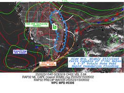
...THERE IS A SLIGHT RISK OF EXCESSIVE RAINFALL FROM SOUTHEASTERN
KANSAS AND NORTHEASTERN OKLAHOMA INTO THE OZARKS...
...Kansas, Oklahoma, Missouri, Arkansas...
There remains a good model signal for the development of heavy
rainfall later today, in what is expected to be the first of
several rounds impacting the region over the next few days.
The synoptic pattern will evolve today into one that will support
heavy rain within periods of organized convection/MCS beginning
tonight. This will be in response to the central part of the CONUS
being sandwiched between an elongated trough to the northeast and a
building ridge over the Four Corners, which leaves broad W/NW flow
across the area. Within this flow, ascent will occur through
periodic impulses moving through the flow combined with the RRQ of
a jet streak aloft. The resultant frontogenesis from the RRQ of the
jet streak will efficiently overlap a warm front wavering in the
area, providing additional lift, which will then be enhanced by
isentropic ascent of the LLJ atop this front.
Forcing will be pronounced, and will act upon favorable thermodynamics,
which will become increasingly robust the latter half of today and
tonight. This will occur as the impressively broad 850mb LLJ
emerges from the Gulf and surges to 40+ kts, angling orthogonally
into the warm front. This will produce strong moisture convergence
as reflected by the moisture transport vectors, and resupply
elevated CAPE of 3000 J/kg northward into the Plains. As convection
blossoms this evening, generally after around 04Z, it will expand
rapidly and organize thanks to 40-50 kts of bulk shear. This will
result in clusters of storms, potentially growing upscale into an
MCS, and training of echoes is likely due to aligned flow to the
warm front. There continues to be some uncertainty into how quickly
the convection will grow into an MCS allowing it to push faster to
the southeast towards daybreak Saturday, but until that happens,
some upstream growth to the NW is expected which will prolong
training of echoes. With a high probability for rain rates
exceeding 2"/hr, any training could lead to rainfall of 2-5", with
locally higher amounts possible (10-20% chance), especially near
the MO/KS/AR/OK intersection.
Another fly-in-the-ointment for the risk area is how elevated
convection north of the warm front, especially early tonight, will
impact the progression SW. There are a few high-res CAMs, and
several global models, that suggest an outflow boundary will be
pushed south more into Oklahoma tonight, which will be aided by
residual boundaries from any dry line convection moving east, and
the front itself. This could result in a bi-modal distribution to
rainfall, and a secondary maxima of flash flood risk across eastern
OK. While confidence is higher in the isentropic/elevated heavy
rain risk farther north, the SLGT risk was tailored a bit SW from
inherited to account for this potential. Otherwise, the inherited
risk areas were modified only cosmetically for recent guidance,
primarily being pulled NW (the MRGL risk area) more into KS for
backbuilding convection during the development stage.
...South Florida...
A weakening front across South Florida will serve as a focus for
slow moving thunderstorms once again today, drifting east to the
Gold Coast through the aftn/eve. This front and a lingering tail of
an upper jet streak will provide synoptic lift into favorable
thermodynamics characterized by PWs of 1.75 to 2.00 inches, and
SBCAPE above 2000 J/kg. This overlap will support rainfall rates
within thunderstorms for which the HREF indicates has a 40% chance
of exceeding 2"/hr, and the 15-min HRRR suggests brief rainfall
intensity of 4"/hr possible. Where these storms slow/stall,
primarily along the southeast coast where they interact with the
sea breeze, this could result in spots of 3-5" of rainfall. Should
this rain occur atop urban areas or over locations that have
received heavy rainfall the past 48-hrs, isolated flash flood
instances could result, so the MRGL risk was maintained.
Weiss
Day 1 threat area:
www.wpc.ncep.noaa.gov/qpf/94epoints.txt
Excessive Rainfall Discussion
NWS Weather Prediction Center College Park MD
1154 AM EDT Fri May 23 2025
Day 2
Valid 12Z Sat May 24 2025 - 12Z Sun May 25 2025
...THERE IS A SLIGHT RISK OF EXCESSIVE RAINFALL FROM SOUTHEASTERN
KANSAS and NORTHEASTERN OKLAHOMA INTO THE OZARKS...
Expect convection to remain ongoing into the early part of the
period, however most of the CAMs show these storms weakening as
they move progressively to the south and east Saturday morning.
Redevelopment is expected back to the north and west beginning in
the afternoon and continuing into the overnight as the low level
jet reintensifies across Southern Plains, replenishing the deeper moisture
pooling along a boundary as it lingers from eastern Oklahoma and
southeastern Kansas through the Ozarks. Additional rounds of heavy
precipitation are expected late Saturday into early Sunday as this
moisture interacts with low-amplitude shortwave energy moving out
of the Plains. Once again, training or backbuilding cells may
contribute to heavy rainfall totals.
Given the lingering uncertainty regarding how much overlap there
will be in the heavy amounts that occur on days 1 and 2, opted to
maintain just the Slight Risk for now. However, an upgrade to a
Moderate this period may be forthcoming should the models start to
show a broader consensus that provides greater confidence.
Pereira
Day 2 threat area:
www.wpc.ncep.noaa.gov/qpf/98epoints.txt
Excessive Rainfall Discussion
NWS Weather Prediction Center College Park MD
1154 AM EDT Fri May 23 2025
Day 3
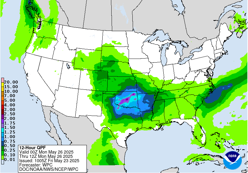
Valid 12Z Sun May 25 2025 - 12Z Mon May 26 2025
...THERE IS A MODERATE RISK OF EXCESSIVE RAINFALL FROM
SOUTHEASTERN KANSAS and NORTHEASTERN OKLAHOMA INTO THE OZARKS...
With many of the detail differences typical of a day 3 period,
there is general model agreement signaling a widespread moderate
to heavy rainfall event that will extend from parts of the
Southern Plains into the Tennessee Valley this period. This will
likely include those areas impacted by heavy amounts during the
previous periods. With some timing and amplitude differences, most
models show a fairly well-defined shortwave moving out across the
Southern Plains by Sunday night. Similar to the previous days,
moisture along the lingering frontal boundary will provide ample
fuel for heavy rain. In contrast the previous days, guidance shows
moisture deepening a little further to the west, supporting heavy
rainfall developing back across northwestern Texas and southwestern
Oklahoma as this system moves across the Plains. Heavy rains will
spread east late Sunday through the overnight, likely impacting
parts of eastern Oklahoma, southeastern Kansas, southern Missouri,
and northern Arkansas once again. With some models showing an
additional 2-4 inches, pushing three day totals over 6 inches in
some locations, the Moderate Risk, which was introduced and
centered over the region in the previous Day 4, was maintained for
the new Day 3. Also maintained was the Slight Risk extending back
through southwestern Oklahoma into northwestern Texas. Part of the
previously noted detail differences contributed to an uncertainty
as to how far south to extend the Slight Risk across eastern
Texas. Some of the models, most notably the ECMWF, show heavy
amounts progressing well to the south over East Texas. For now,
kept the Slight Risk closer to the broader consensus centered
farther north.
Pereira
Day 3 threat area:
www.wpc.ncep.noaa.gov/qpf/99epoints.txt
Extended Forecast Discussion
NWS Weather Prediction Center College Park MD
256 AM EDT Fri May 23 2025
A wet and wavy west-east oriented front will be well in place over
The South Memorial Day. Moisture and instability in place will
fuel activity with heavy rain rates in areas likely to receive
precursor short range rains to moisten soils. The Day 4/Monday WPC
Excessive Rainfall Outlook (ERO) still shows a Marginal Risk area
from eastern Texas to the southern Appalachians. Within this area,
a Slight Risk area has been introduced from far northeast Texas
through central Tennessee and northern Alabama given an increasing
favorable guidance focus, including instability/right entrance
region upper jet support. By Tuesday into Wednesday, the eventual
dominant low on the frontal system should lift northeast toward the
Appalachians and onward to bring localized heavy rain to portions
of the Eastern Seaboard, especially the Mid-Atlantic, while the
trailing front lingers to focus showers and storms across the
South. A WPC Day 5 ERO Marginal Risk area was introduced for this
elongated threat area given still deep moisture and upper support.
Farther north, the initial trough should produce some modest
precipitation in the central Rockies (even some snow in the highest
peaks), with moderate convection over the northern/central Plains
early next week. The frontal boundary curling back into the
southern/central Rockies and High Plains could help produce
scattered convection there next week as well. Meanwhile, rounds of
fronts coming through the Pacific Northwest could allow for light
to moderate precipitation. Summertime scattered storms are also
likely across the Florida Peninsula.
Hot weather will particularly linger into Monday for parts of
Texas. Temperatures from well into the 90s to triple digits will
focus areas of Major HeatRisk in southern Texas. Meanwhile, cooler
than normal temperatures by 5 to 15 degrees will take hold over
the north-central to eastern U.S. into early next week underneath
upper troughing. The trough and front pressing south will allow for
temperatures to cool in the southern tier Monday and Tuesday. The
cooler temperatures should gradually moderate closer to normal as
next week progresses. But in the West, a building upper ridge will
lead to warmer than average temperatures by 10 to 20 degrees for
several days spread from the Great Basin to the West/Northwest.
Schichtel


