Excessive Rainfall Discussion
NWS Weather Prediction Center College Park MD
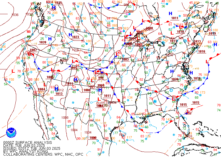
845 PM EDT Tue Jun 3 2025
Day 1
Valid 01Z Wed Jun 04 2025 - 12Z Wed Jun 04 2025
...THERE IS A SLIGHT RISK OF EXCESSIVE RAINFALL FOR PORTIONS OF THE
PLAINS INTO MISSOURI AS WELL AS FOR PORTIONS OF SOUTHEASTERN
CALIFORNIA AND NORTHERN ARIZONA...
...01Z Update...
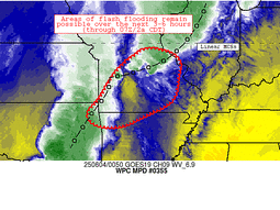
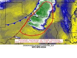
The storms across the middle of the country have become much more
progressive and are therefore winding down as regards the flooding
threat. There remains some potential for pre-line cells to moisten
up the soils before the line moves through, so the Slight remains
from where the line is now through the inherited forecast. There is
some potential in the guidance for renewed mostly shower activity
in this same area after about 09Z or so, and given the sensitivity
in some of those areas, have left the Slight intact east of the
line of storms.
In Florida, the convection has waned and the heaviest convection is
largely offshore and in the Keys. Certainly periods of heavy rain
will remain possible through the night, but are unlikely to cause
more than isolated flash flooding.
The inherited Marginal and Slight Risk areas out west remain
largely unchanged, albeit with a small expansion of the Marginal
into the L.A. Basin, given the ongoing showers and storms there.
The storms will likely wane in coverage post-sunset, but there
remains a few more hours of flash flooding potential, especially
into parts of southern California, northern Arizona and
northwestern New Mexico for the next few hours.
Wegman
Day 1 threat area:
www.wpc.ncep.noaa.gov/qpf/94epoints.txt
Excessive Rainfall Discussion
NWS Weather Prediction Center College Park MD
845 PM EDT Tue Jun 3 2025
Day 2
Valid 12Z Wed Jun 04 2025 - 12Z Thu Jun 05 2025
...THERE IS A MARGINAL RISK OF EXCESSIVE RAINFALL FOR PORTIONS OF
THE MIDWEST, MIDDLE MISSISSIPPI VALLEY, SOUTHERN PLAINS, THE FOUR
CORNERS/DESERT SOUTHWEST, AND THE SOUTHEAST...
...2030Z Update...
Changes to the Day 2 ERO for this cycle were relatively minor.
Expanded the Four Corners Marginal Risk on the western side to
encompass parts of eastern California and southern Nevada. HREF
probabilities for exceeding 3 and 6 hour FFG guidance are scattered
through much of the Southwest once again Wednesday. However, the
HREF mean etc. shows lower instability compared to today (Tuesday)
and support aloft is not quite as strong, so held off from a Slight
Risk, but expect possibly isolated to scattered flash flooding, but
possibly less focused. Another area to watch for a potential
Slight is the southern High Plains, for nocturnal convection that
may produce heavy rain rates before 12Z Thursday, but looks to ramp
up specifically Thursday/Day 3 period. Meanwhile, expanded the
Marginal Risk in south-central Texas for some Wednesday morning
ongoing convection. The Southeast to Florida Marginal Risk remains
similar to the previous outlook.
Tate
...Previous Discussion...
...Four Corners into Central/Southern High Plains...
Another active day of showers and thunderstorms expected as the
upper low over northern Baja fills and ejects northeast atop the
Four Corners. The accompanying ascent will move into continued
anomalous PWs which will exceed the 99th percentile (per NAEFS).
This will fuel widespread convection capable of localized rainfall
rates of 0.5"/hr (or at times higher). Storms will likely move
slowly beneath the upper trough, leading to a longer duration of
heavy rain. Although total rainfall will be modest in most areas
(as reflected by relatively low 24-hr probability from ECENS/GEFS
for 1" exceedance), where the heavy rain impacts sensitive terrain
features or urban areas instances of flash flooding could result.
Probabilities have also increased a bit (particularly from the new
00z ECENS suite) further east into the Central/Southern High
Plains and the MRGL risk has been expanded accordingly. Should
models come into better agreement, additional expansion may be
needed further south into West TX (and with additional CAM guidance
and agreement, an upgrade to SLGT may also be needed).
...Southern Plains and Mid-Mississippi Valley to Great Lakes...
The cold front from D1 will continue its trek eastward on
Wednesday, but will start to slow and become aligned more west to
east as its tail gets pulled northward by an approaching shortwave
over the Four Corners region. Shortwaves embedded within the flow
will continue to race northeast, especially from Missouri to
Michigan, which is where the greatest concentration of
thunderstorms is expected on D2 (though some models are also
indicated potential for isolated convective development farther
southwest into portions of the Southern Plains). Storm motions
along the front are likely to be progressive, lifting off to the
northeast on 0-6km mean winds of 20-30 kts, but weaker Corfidi
vectors aligned both to this mean wind and the front suggests a
potential for training. As rainfall rates peak above 1"/hr within
favorable thermodynamics, this could result in stripes of heavy
rainfall with ensembles indicating 10-40% chance of exceeding 1"
and up to 10% probabilities for exceeding 2" (with the new ECENS
being the most aggressive). The inherited MRGL risk was maintained
(and expanded a bit southwest) with this update.
...Southeast...
Guidance continues to be somewhat aggressive with
a wave of low pressure potentially developing along an inverted
trough shifting northeast along the FL/GA/SC coasts. While NHC
continues to indicate a 10% probability of tropical or sub-tropical
development with this feature, regardless of whether a circulation
forms or not, there continues to be increasing confidence that
heavy rain will spread across the FL Peninsula and then rotate
onshore the GA/SC coasts on Wednesday. There also has been a clear
model trend of potential increased convective development farther
inland to the FL Panhandle and into southeast AL and southwest GA
(likely due to a stronger closed low and the associated dynamics),
so the MRGL was expanded to reflect this. With PWs progged to
exceed 2", above the 90th percentile, supported by warm cloud
depths that may exceed 15,000 ft, efficient rainfall rates of
1-2"/hr will be likely in any showers/thunderstorms. It certainly
remains possible that the heaviest rainfall in association with the
potential surface low will remain just offshore, but impressive
moisture convergence from Jacksonville, FL to Charleston, SC should
support waves of heavy rainfall regardless of development of this
system. Additionally, plentiful tropical moisture across the rest
of the FL Peninsula and a shortwave continuing to pivot across the
Gulf could enhance rainfall over much of Florida Wednesday, and the
MRGL was maintained accordingly (with the exception of the FL
Keys, which were removed due to model consensus that convection
will be pulling away northward by 12z Weds).
Churchill/Weiss
Day 2 threat area:
www.wpc.ncep.noaa.gov/qpf/98epoints.txt
Excessive Rainfall Discussion
NWS Weather Prediction Center College Park MD
845 PM EDT Tue Jun 3 2025
Day 3
Valid 12Z Thu Jun 05 2025 - 12Z Fri Jun 06 2025
...THERE IS A SLIGHT RISK OF EXCESSIVE RAINFALL FOR PORTIONS OF
THE SOUTH-CENTRAL PLAINS...
...Central Great Basin to Central/Southern Plains into the Ohio Valley...
Thursday/Day 3 should see a similar pattern as Wednesday/Day 2,
with a broad positively tilted trough axis across the West and
shortwaves moving through. Pacific moisture (continuing to be over
the 90th percentile for PWs) will stream northeastward just ahead
of the trough to produce scattered convection across the central
Great Basin toward the central Rockies, so expanded the Marginal
Risk into these areas with the axis just a bit north of the
previous couple of days.
Farther east, an initial shortwave will force convection in the
southern High Plains Wednesday night into Thursday morning. Then a
renewed low level jet will push moisture and instability a bit
farther north into Oklahoma/Kansas Thursday night and likely
sustain convection that originates in Colorado, leading to heavy
rain rates. For this issuance, combined both these areas into the
Slight Risk. There continues to be some model spread in heavy
rainfall placement and with which MCS may lead to the heavier
totals, with most recent ECENS probabilities of exceeding 1" and 2"
focused in Oklahoma whereas GEFS probabilities are centered in
Kansas. So more refinements may be necessary in future cycles.
Expanded the Marginal farther south in West Texas for convection
with heavy rain rates just east of the dryline.
To the east, moisture pooling along a meandering front may lead to
locally heavy rain across the Mid-Mississippi Valley and Ohio
Valley toward the Lower Great Lakes region. A Marginal Risk remains
in place for these areas. Considered a Marginal Risk stretching
into northern New England near/ahead of the front where above
normal moisture and instability are likely, but model QPFs were not
very heavy. There is likely a nonzero probability though so will
continue to monitor.
...Southeast/Carolina Coast...
Model guidance indicates a low pressure system potentially just
onshore in the Carolinas near the Atlantic coast on Thursday. This
system is most likely to be frontal but with a low end chance of
becoming tropical or subtropical per NHC. Heaviest rainfall totals
are forecast to stay offshore. However, wraparound moisture will
stream into coastal areas with PWs above the 90th if not 95th
percentile. Instability though generally looks to remain below 1000
J/km west of the low, which may limit rain rates somewhat. Per
coordination with the Morehead City (MHX) WFO, antecedent
conditions are wetter than normal along coastal areas due to recent
rain. So will continue to monitor this area for a Slight Risk
eventually, but will await better model convergence and see if
instability increases. Expanded the preexisting Marginal west a bit
per some 12Z models that were farther inland.
Tate/Churchill
Day 3 threat area:
www.wpc.ncep.noaa.gov/qpf/99epoints.txt
Extended Forecast Discussion
NWS Weather Prediction Center College Park MD
258 PM EDT Tue Jun 3 2025
The National Hurricane Center is monitoring the potential
development
of a sub-tropical feature off the Southeast Coast. Deepest
moisture may stay offshore and uncertainty is high, but there is a
chance of some heavier rainfall along the coast. WPC maintained the
Marginal Risk of excessive rain for Friday over coastal North
Carolina as the low lifts slowly up the coast in warm and moist
Gulf Stream waters.
Meanwhile, numerous showers and thunderstorms are expected to fire
along a slow-moving and wavy front that will stretch from the
Northeast and Ohio Valley states down to the Southern Plains.
Abundant moisture pooled over the region along with a steady
influx from the Gulf coupled with shortwave/jet support will help
prime the environment for embedded heavy rain potential. This
environment may be conducive for isolated areas with accumulations
of several inches, but local focus details are proving quite
varied in guidance from run to run. WPC has a broad Marginal Risk
spanning from the Plains to the Great Lakes/Northeast Friday into
the weekend. Within the Marginal is a smaller area highlighted
with a Slight Risk of excessive rainfall mainly for Oklahoma, but
also into the adjacent counties of Arkansas and southwest Missouri.
The southern trailing tail of the elongated boundary will stall
and weaken over the southern Plains. Dynamic upper closed
low/trough digging into the north-central U.S. from the weekend
into early next week will spawn fronto/cyclo genesis, with
baroclinicity rejuvenated more broadly again that may act to
spread heavy rainfall focus across the Mid-South and Tennessee
Valley then down across the Mid-Atlantic and the South/Southeast.
Summer heat will build across the Interior Northwest/West and into
the Desert Southwest with establishment of mean upper ridging over
the weekend into next week. Maximum temperatures over the interior
Northwest may range upwards to 20-25F degrees above normal. Areas
from south Texas into the Gulf Coast will also experience rising
temperatures, cresting upwards of 105F by the weekend over South
Texas to push heat index values dangerously upwards to 110-115F.
Please take heat safety precautions such as increased water intake
and more time in air conditioned areas to avoid heat exhaustion
and heat stroke. See weather.gov/heat for more information on
safety tips and resources.
Campbell/Schichtel


