Excessive Rainfall Discussion
NWS Weather Prediction Center College Park MD
850 PM EDT Fri Jun 6 2025
Day 1
Valid 01Z Sat Jun 07 2025 - 12Z Sat Jun 07 2025
...THERE IS A SLIGHT RISK OF EXCESSIVE RAINFALL FOR PORTIONS OF
THE SOUTHERN PLAINS AND OHIO VALLEY...
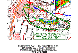
...Texas Caprock...
Multiple supercells will continue to plague the area within WFO
Lubbock, TX CWA bounds with cells originally forming within the
Caprock and moving eastward within the mean layer flow. Sufficient
buoyancy and shear across the Southern High Plains will maintain
severe thunderstorm posture for at least another 2-4 hours before
any convection begins to collapse, or even induce cell mergers in
the case of the activity between the NM/TX state lines through
Northwest TX. Rainfall rates between 2-3"/hr with intra-hour rates
up to 5"/hr will lead to flash flood concerns over an area still
recovering from yesterdays barrage of rainfall from a similar
convective evolution. The previous SLGT was generally maintained
with a minor expansion to the northern edge to encompass left-
moving supercells that are making headway towards the southern
portion of the Panhandle.
...Southern Plains to Ozarks...
A repeat of the pattern last evening with multiple mesocyclones
currently situated over the Southeast CO Front Range will shift
southeast with general motion with the upwind propagation vector. A
distinct split heavy rain axis will transpire across the eastern TX
Panhandle into OK with another across the Northern half of OK into
Southern KS as the cells eventually merger into a large MCS that
will propagate southeast towards Eastern OK into the Northwest AR
Ozarks by the end of the forecast. Heavy rainfall between 2-4" with
locally as high as 5" are forecast within the confines of the
northern half of the expected complex, crossing through a region
with saturated antecedent grounds thanks to the previous mornings
MCS that hit the same areas as expected tonight. Anywhere from the
I-40 corridor on north will have the potential for flash flooding
due to the MCS with a high-end SLGT risk positioned over the OK/KS
border where 1/3/6 hour FFG's have been significantly degraded from
previous activity last night into this morning. The SLGT risk was
expanded on the northern edge from previous update to attribute to
the latest heavy QPF footprint on the upwind side of the expected
MCS development this evening.
...Ohio Valley...
Large cluster of thunderstorms capable of 1-2"/hr rates will
continue to maneuver eastward through the Ohio River Basin down
into KY with a secondary batch of convection moving through TN with
a few stronger cores. Shortwave energy associated with the cell
conglomeration will motion eastward into the Central Appalachian
Front leading to scattered heavier convection to shuffle through
the Ohio River basin and KY into WV overnight. Signals for a few
heavier cells over the terrain of Eastern KY into WV have been
steady in the CAMs through the course of the day with some areas
already been affected by previous heavy rain output during the D1
time frame. FFG's remain relatively low in those areas from all the
prior precip with some areas likely to reach over 2" in 24 hrs from
all the convective impact in the time period. Considering the
threat for heavy precip in back-to-back posture, a SLGT risk was
maintained over KY and expanded to the east to include WV where
hourly CAMs have been more aggressive with heavier QPF signals in
the latest iterations.
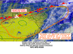
...West Texas...
Sufficient surface based instability on the order of 2000-4000 J/kg
has allowed for scattered thunderstorms development across
Southeast NM down through the Upper Trans Pecos of TX. Mean storm
motions of 15-20 kts to the east should maintain relatively steady
forward momentum of convection through the evening, but any strong
convective core could throw out an easy 1-2" total within a short
period of time leading to localized flash flood concerns over
Southeast NM, Northwest Permian Basin, down through the mountains
of Southwest TX. A MRGL risk remains for those areas, but was
trimmed on either side to fit a more narrow axis where storms could
survive before hitting a more capped environment near the Pecos
river and points east.
Kleebauer
Day 1 threat area:
www.wpc.ncep.noaa.gov/qpf/94epoints.txt
Excessive Rainfall Discussion
NWS Weather Prediction Center College Park MD
413 AM EDT Sat Jun 7 2025
Day 1
Valid 12Z Sat Jun 07 2025 - 12Z Sun Jun 08 2025
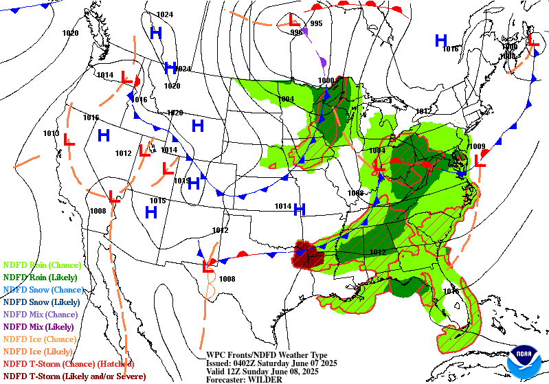
...THERE IS A SLIGHT RISK OF EXCESSIVE RAINFALL ACROSS THE LOWER
ARKANSAS VALLEY, LOWER MISSISSIPPI VALLEY INTO THE LOWER TENNESSEE
VALLEY AND OVER CENTRAL NEW ENGLAND...
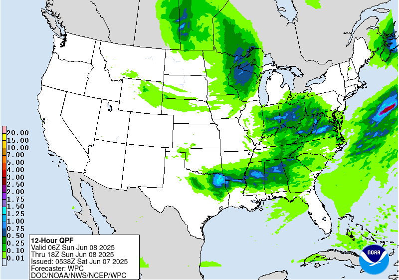
The next round of shortwave energy pushing into the Central to
Southern Plains early Saturday morning will progress into the Lower
MO Valley/Mid MS Valley/OH Valley region during the day Saturday.
This upper trof will become more negatively tilted with a well
defined area of upper difluence pushing eastward. Convection
likely to enhance in this broad upper difluence region where PW
values will remain 1.5 to 2+ standard deviations above the mean
across a large region from the OH Valley, south into the Mid to
Lower MS Valley and TN Valley. Across the northern portions of the
precipitation area from the Lower OH/Mid MS Valley region,
consensus is for the next round of precip to fall just to the north
of where the heavy amounts fell over the past 24 hours. This
should reduce the risk of runoff issues. Given that there is not
expected to be a significant overlap of day 1 precip with the
previous 24 hours observed precip, the risk level was kept as
marginal here.
Farther to the south, not a lot of changes made to the broad slight
risk area from the Lower AR, Lower MS Valley, east into northern MS
and northern AL. The slight risk area continues to fit well with
the axis of high HREF neighborhood probabilities for 1 and 2"+
amounts this period. There may be more than 1 round of convection
to move across this region. The initial, early day 1 from the
convection currently enhancing over the Southern Plains, followed
by a second round late Saturday afternoon along the surface frontal
boundary. With each round of convection, hourly rainfall totals of
.50-1"+ possible.
...Southeast NY State into New England...
Another round of convection likely day 1 along the frontal
boundary pushing through the northeast as a sharpening northern
stream trof pushes across the Northeast. A slight risk area was
introduced from the previous issuance to correspond to where there
is an overlap between heavy precip from Friday afternoon and
expected additional heavy precip between 1500 UTC Sat and 0000 UTC
Sun. This corresponds to an area from north central MA, across
southern NH into southwest ME. In this region the latest HREF
probabilities for .50 and 1"+ hourly amounts are fairly high and
where soils have become increasingly saturated.
Oravec
Day 1 threat area:
www.wpc.ncep.noaa.gov/qpf/94epoints.txt
Excessive Rainfall Discussion
NWS Weather Prediction Center College Park MD
413 AM EDT Sat Jun 7 2025
Day 2
Valid 12Z Sun Jun 08 2025 - 12Z Mon Jun 09 2025
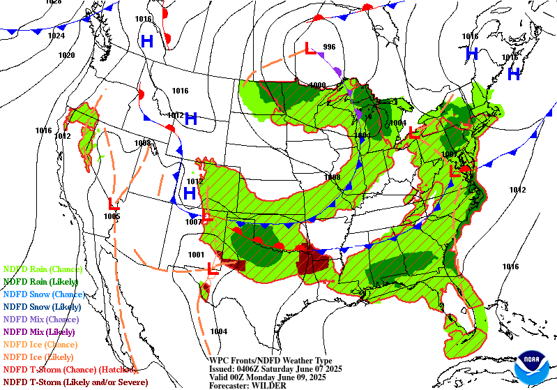
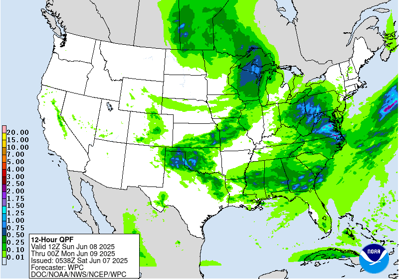
...THERE IS A SLIGHT RISK OF EXCESSIVE RAINFALL ACROSS NORTHERN
TEXAS AND SOUTHERN OKLAHOMA...
...Southern Plains to the Southeast...
The latest guidance remains consistent in showing additional
shortwave energy pushing east southeastward late Sunday
afternoon/evening from the lee of the Central to Southern Rockies
into the Southern Plains in the northwest flow on the south side
of a stronger upper level low centered over the north-central
United States. This will again re-strengthen the low level flow
into the west to east oriented front forecast to remain across the
Southern Plains, supporting another round of organized convection
along the front. There continues to be fairly good agreement on
the potential for an axes of heavy precip day 2, resulting in good
continuity with the slight risk area with only some small changes
to reflect the latest forecasts. This next round of organized
convection will likely be fairly progressive, similar to what
occurred farther to the north Thursday night into early Friday and
Friday night into early Saturday. Still, there is likelihood of
widespread rainfall amounts of 1-2" with localized amounts up to
4". Soils are not as saturated as areas farther north, but
localized runoff issues are still likely.
...Central Appalachians into the Mid-Atlantic...
The negatively tilted shortwave coming out of the OH Valley late
day 1 will push across the Central Appalachians into the Mid-
Atlantic day 2. There is a fair amount of spread with model qpfs,
but a signal for the potential for locally heavy rains in the
continued well defined area of upper difluence ahead of these
height falls in an axis of above average PW values...1.5 to 2+
standard deviations above the mean. There were only some minor
changes made to the previous marginal risk across the Central
Appalachians into the Mid- Atlantic, continuing to center it across
areas that have lower ffg values.
Oravec
Day 2 threat area:
www.wpc.ncep.noaa.gov/qpf/98epoints.txt
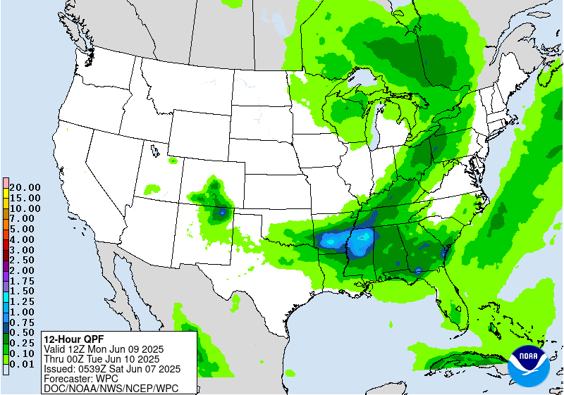
Excessive Rainfall Discussion
NWS Weather Prediction Center College Park MD
413 AM EDT Sat Jun 7 2025
Day 3
Valid 12Z Mon Jun 09 2025 - 12Z Tue Jun 10 2025
...THERE IS A MARGINAL OF EXCESSIVE RAINFALL ACROSS THE SOUTHERN
PLAINS, LOWER MISSISSIPPI VALLEY, NORTHEAST THROUGH THE TENNESSEE
VALLEY, UPPER OHIO VALLEY AND INTO THE EASTERN GREAT LAKES...
There is good agreement in the latest guidance with the slow
eastward push of the closed low through the Upper Lakes day 3 and
the broad upper troffing extending south of this center through the
MS and OH Valleys. A broad region of above average PW values will
continue to stretch across the southern tier from the Southern
Plains, east across the Lower MS Valley and into the Southeast
along and ahead of the lead west to east oriented front. Another
axis of above average PW values will push northeastward across the
TN and OH Valleys into the Lower Lakes ahead of a secondary front
rotating through the cyclonic flow on the southeast side of the
strong closed low over the Upper Lakes. Along each frontal
boundary, widespread moderate to locally heavy precip totals are
likely. Model agreement, however, is not great with placement of
maximum amounts, leading to overall low confidence in where
anything but a marginal risk could be drawn. Overall, the previous
broad marginal risk area fits well with the latest model qpf
spread, with no significant changes made to previous outlook for
the new day 3 outlook.
Oravec
Day 3 threat area:
www.wpc.ncep.noaa.gov/qpf/99epoints.txt
Extended Forecast Discussion
NWS Weather Prediction Center College Park MD
214 AM EDT Sat Jun 7 2025
A trailing frontal boundary draped generally west to east across
the South will provide focus for numerous showers and thunderstorms
through much of next week. The Days 4 and 5 Excessive Rainfall
Outlooks (valid Tuesday and Wednesday) reflect this. For Day 4, a
very broad marginal risk stretches all the way from the southern
Plains/High Plains to the Gulf Coast states. Models are starting to
show better consensus on potentially flooding rains impacting
central Texas, but still with enough uncertainty to preclude a
slight risk at this time. For Day 5, there is better agreement on
heavy to excessive rainfall again in central Texas, and combined
with rainfall in the same region on Day 4, went ahead and added a
slight risk to the ERO for tonight. By Thursday, this boundary
looks to lift northward with heavy rainfall potential moving into
the central Plains/mid-Mississippi Valley which has been wet as of
late and will need to be monitored for flooding concerns later this
week.
The northern portion of this boundary should be quicker to move
through the East, but heavy rainfall is possible along the boundary
amidst ample moisture and instability and favorable upper level
dynamics. A marginal risk for the interior Northeast remains on the
Day 4 ERO. Elsewhere, additional short wave energy interacting
with a frontal boundary across the northern tier will bring showers
and storms from parts of the northern Rockies into the Upper
Midwest. Marginal risk areas were added to the Day 5/Wednesday ERO
tonight for parts of Montana and also South
Dakota/Minnesota/Wisconsin.
Much above normal temperatures will continue into early next week
for the Northwest, with anomalies of +20-25F likely to continue on
Tuesday. This should equate to a moderate to major HeatRisk for
parts of this region along with widespread record highs.
Temperatures and HeatRisk should by Wednesday, but remain slightly
above normal, including farther south into the central Great Basin.
Short range heat across South Texas should be much less extreme by
Tuesday as an upper level shortwave moves into the region. By next
Thursday-Saturday, most of the country will be near or within a
few degrees of normal.
Santorelli


