Excessive Rainfall Discussion
NWS Weather Prediction Center College Park MD
815 PM EDT Fri Jun 13 2025
Day 1
Valid 01Z Sat Jun 14 2025 - 12Z Sat Jun 14 2025
...A SLIGHT RISK OF EXCESSIVE RAINFALL EXISTS FOR PORTIONS OF THE
MID-SOUTH INTO THE TENNESSEE AND OHIO VALLEYS, CENTRAL
APPALACHIANS INTO THE MID-ATLANTIC, AND THE NORTHWEST GULF COAST...
...Mid-Atlantic...
2300 UTC Update -- Pulled the Slight and Marginal Risk areas a
little farther west (from the Atlantic Coast) based on the latest
observational trends along with recent HRRR/RRFS runs and the 18Z
HREF exceedance probabilities.
Hurley
Previous Discussion...Stalled frontal boundary stretching across
the Delmarva Peninsula towards the Upper Ohio Valley will combine
with increasing atmospheric moisture content (1.5-2.0" PWs by this
evening) to create efficient rainfall rates within thunderstorms.
The southerly mid-level flow will be aided by an upper low
currently analyzed over southern MO, but with troughing stretching
from the Midwest to the western Gulf. Convection is most likely to
trigger first across the Carolinas and the elevated terrain of the
Blue Ridge up through the central Appalachians. Mean column wind
speeds of 20 kts out of the west should promote some propagation of
storms, especially once a cold pool is established, but complex
terrain and areas right along the frontal boundary could exhibit
some training potential along with rainfall rates up to 2"/hr. The
inherited Slight Risk was maintained and expanded a bit westward to
encompass more of the sensitive Blue Ridge mountains of
central/northern VA. 12z HREF guidance depicts 30-50% chances for
3" totals within 6 hours this evening across central VA. This along
with the available moisture content and nearby frontal boundary
support the potential for scattered instances of flash flooding and
the potential for localized considerable impacts in the sensitive
terrain near the Blue Ridge as well as urban locations between
southern MD and northeast NC. However, some guidance (including the
12z HRRR and experimental 06z RRFS) are mostly void of excessive
rainfall coverage, which does prompt some uncertainty during the D1
period.
...Mid-Mississippi Valley and Lower Ohio Valley...
2300 UTC Update -- Based on the latest observational and guidance
trends, have nudged the Slight Risk area a bit farther east to
include more of the TN and OH Valleys.
Hurley
Previous discussion...Isolated flash flooding is still possible
across parts of central MO/IL underneath and near the low center,
but coverage of heavy rain does not seem widespread enough to
warrant a Slight Risk. Moisture and effective bulk shear will be
plentiful across much of the Mid-Missippi Valley and lower Ohio
Valley while ML CAPE will be sufficient for organized convection in
a number of areas. PW values of 1.75-2.0" will near the 90th
climatological percentile per the 00z ECENS. The risk percentage
for AR is in decline as the heavy rain signal appears better
elsewhere, but lowish flash flood guidance and the Ozarks should
prove sufficient for widely scattered to scattered flash flood
concerns, especially given the potential for storms to re-ignite
late tonight under the influence of an increasing low-level jet.
Flash flood guidance is many ares appears compromised by recent
rainfall (during the past week). Overall, the expectation is for
isolated to scattered instances of flash flooding and the greatest
concern located within urban and poor drainage locations.
...Northwest Gulf Coast...
Showers and thunderstorms are forecast to retrograde from southwest
LA across sensitive areas of Southeast TX this morning within an
area of low- level convergence and retreating/eroding instability.
This occurring after extreme rainfall amounts (7"+) impacted
south-central LA early this morning. Additional hourly rain
amounts to 2.5" with local totals to 5" are probable along the
northwest Gulf Coast due to sufficient effective bulk shear,
moisture, and instability, which would be most problematic where it
rained heavily on Thursday and within urban areas. 12z HREF
probabilities for greater than 5" in 6 hrs are 15-20% and scattered
throughout the region.
...Texas Panhandle and Caprock Region...
Dryline convection this evening is expected along much of the High
Plains, but also as far south as the Texas Panhandle and western
Texas where 1-1.25" PWs remain. 3-hr FFGs in the region are below
3" and have been somewhat wet as of the last month (100-200% of
normal for some locations). A Marginal Risk was added given the
potential for numerous thunderstorms, while progressing eastward
steadily, could merge and lead to brief periods of training.
...Northern WI/Michigan U.P....
Area of low pressure moving eastward through MN helps drive a
risk for heavy rainfall within narrow bands from MN across
northern WI Friday morning. Instability appears sufficient in spots
(500+ J/kg of MU CAPE) for pockets of organized convection capable
of heavy rainfall, but isentropic lift/low- to mid-level
frontogenesis is expected to aid heavy rainfall production as well.
Hourly amounts to 1.5" with local amounts to 3" are possible where
cells train. The inherited Marginal Risk was shrunk based on radar
and latest CAM trends.
...Northern Rockies/Western High Plains...
The Marginal Risk across Montana maintained along the western
interface of the deeper moisture and instability over much of the
Plains on the leading edge of a quasi-stationary upper level trough.
Snell/Roth
Day 1 threat area:
www.wpc.ncep.noaa.gov/qpf/94epoints.txt
Excessive Rainfall Discussion
NWS Weather Prediction Center College Park MD
338 AM EDT Sat Jun 14 2025
Day 1
Valid 12Z Sat Jun 14 2025 - 12Z Sun Jun 15 2025
...THERE IS A SLIGHT RISK OF EXCESSIVE RAINFALL FOR PORTIONS OF
THE MID ATLANTIC AND ALSO THE SOUTHERN PLAINS...
...Mid-Atlantic...
An unsettled weather pattern continues across much of Virginia and
extending into adjacent portions of eastern West Virginia and
northeast North Carolina going into Saturday and Saturday night.
Multiple rounds of slow moving showers and thunderstorms will
develop generally along and ahead of a cold front that is gradually
settling to the south across Virginia. This boundary is
intercepting an anomalously moist airmass with PWs on the order of
1.75 to 2 inches and mixed layer CAPE on the order of 1000 J/kg on
average. The band of highest QPF is expected to be from the
northern Shenandoah Valley to the Hampton Roads area of Virginia,
with 2 to locally 4 inches of rainfall possible. Slow cell motions
and efficient rainfall could result in some hourly rainfall rates
approaching 2 inches per hour, especially where cell mergers occur.
This could result in some instances of flooding, especially across
urban locations and also areas that had heavy rainfall through the
early morning hours Saturday.
...Southern Plains, Southeast, and Tennessee/Ohio Valleys...
A lower tropospheric trough tracks southeastward across the Ohio
Valley over the weekend. This will be traversing a moist
environment with sufficient effective bulk shear along and near
its associated fronts with greater instability. Slow moving
convection and brief organized training is possible. A more
cellular convective mode is likely near the low over the Ohio
Valley, where isolated flash flooding could occur. Along the
southern flanking inflow band, mean wind becomes more westerly and
parallel to developing convection across central and northern
Alabama and Mississippi.
Farther west, cell training due to storms moving south or
southeast down the stationary instability gradient across Kansas
and Oklahoma could be problematic if it occurs for an extended time
period, and some of the recent CAM guidance depicts this scenario,
although there are still considerable mesoscale differences on
placement and magnitude. However, there is high confidence that a
mesoscale convective complex will develop with locally high
rainfall rates. The inherited Slight Risk was maintained although
it is a little larger than the previous issuance.
...Upper Midwest...
A warm advection pattern returns to the region, bringing
a return to more widespread organized convection, mainly during
the 00Z-12Z time period Sunday. Heavy rainfall over this same
region in recent days has resulted in saturated soils in many
cases, and this will increase the vulnerability to flooding, even
though the expected rainfall is not expected to be overly
impressive with mainly 1 to locally 2 inch totals expected, and
therefore a Marginal Risk area remains valid for this time period.
...Central Montana...
A wave of low pressure developing along a frontal boundary should
provide enough forcing to produce some scattered 1 inch rainfall
totals across this region, mainly late Saturday afternoon into the
evening as CAPE increases and dewpoints getting well into the 50s.
Some of the storms that develop may produce high enough rainfall
rates to result in a few instances of flooding.
Hamrick
Day 1 threat area:
www.wpc.ncep.noaa.gov/qpf/94epoints.txt
Excessive Rainfall Discussion
NWS Weather Prediction Center College Park MD
338 AM EDT Sat Jun 14 2025
Day 2
Valid 12Z Sun Jun 15 2025 - 12Z Mon Jun 16 2025
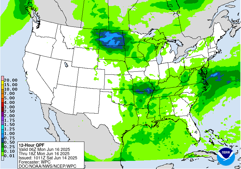
...A SLIGHT RISK OF EXCESSIVE RAINFALL EXISTS FOR THE MID-ATLANTIC
AND ALSO NEAR THE OZARKS...
...Southern Mid-Atlantic States and Central Appalachians...
It remains the case that a corridor of enhanced moisture
convergence will exist across the Mid-Atlantic region going into
Sunday, and thus widespread rain for Father's Day. The frontal
boundary makes a little more southward progress with the axis of
highest instability expected to generally be south of the
Interstate 64 corridor. Therefore, the main QPF axis is progged
from eastern WV/SW Virginia to near the VA/NC border with
widespread 1-3 inch totals within this band, and locally higher.
The latest HREF probs of flash flood guidance exceedance are
greatest Sunday afternoon/evening across portions of eastern WV and
western VA where antecedent conditions will be quite saturated, and
another area of exceedance across southeast VA. Depending on what
evolves through Saturday night, if the axis of heaviest rainfall on
Sunday is close to or over the previous day's event, a future
Moderate Risk could be needed, but for now a Slight Risk remains
the best approach.
...Northern Plains into the Midwest and Mid-South...
A building upper ridge situated over the southern Rockies will tend
to result in northwest flow aloft across the northern Plains to the
ArkLaTex region. Multiple convective complexes are likely to
develop on the eastern periphery of this upper ridge, and
convective development will depend on whether a low-mid level cap
can be eroded, and this is more likely to happen across eastern
portions of Kansas/Oklahoma/Texas. The latest model guidance is
converging more on a concentrated area of enhanced rainfall across
portions of southwestern Missouri and northwestern Arkansas and
adjacent portions of Kansas and Oklahoma, where an organized MCS is
more likely to develop. Therefore, a Slight Risk area has been
introduced for this region.
Hamrick
Day 2 threat area:
www.wpc.ncep.noaa.gov/qpf/98epoints.txt
Excessive Rainfall Discussion
NWS Weather Prediction Center College Park MD
338 AM EDT Sat Jun 14 2025
Day 3
Valid 12Z Mon Jun 16 2025 - 12Z Tue Jun 17 2025
...A MARGINAL RISK OF EXCESSIVE RAINFALL IS VALID FOR PORTIONS OF
THE UPPER MIDWEST, MID-SOUTH, AND THE MID-ATLANTIC...
...Mid-Atlantic region...
Overall, an improvement compared to what is expected over the
weekend, but there should still be enough moisture in the general
vicinity of a stalled stationary boundary over southern Virginia
and North Carolina to produce scattered storms with heavy rainfall.
Although the magnitude of rainfall expected on Monday is not
impressive, the very saturated ground by this time will be an
aggravating factor in terms of flooding potential, and therefore a
Marginal Risk area is valid from central West Virginia to the Outer
Banks of North Carolina.
...Mid-South...
The latest model guidance is honing in on a potential MCS that
could develop across portions of eastern Arkansas into western
Tennessee on Monday, and perhaps extending into portions of
southern Missouri and western Kentucky where the potential exists
for 1 to locally 2 inches of rainfall. A Marginal Risk area is
valid here since much of this rain would likely happen over a two
hour time period.
...Dakotas to the western Great Lakes...
A surface low over South Dakota with broad warm air advection ahead
of it will fuel the development of additional scattered showers and
storms on Monday. The model guidance remains varied in regards to
placement of QPF maxima, so a broad Marginal Risk is valid.
Day 3 threat area:
www.wpc.ncep.noaa.gov/qpf/99epoints.txt
Extended Forecast Discussion
NWS Weather Prediction Center College Park MD
253 AM EDT Sat Jun 14 2025
Highly unsettled weather will remain in the forecast across much
of the central/eastern U.S. through at least the middle of next
week as numerous embedded impulses in the upper-levels override
frontal boundaries with seasonable moisture in place. Uncertainty
remains with the specific day-to-day details given the short-wave
energies, frontal placement, and likely mesoscale boundaries from
prior days' storms driving new development each day. However, a
more focused corridor is apparent across the central/northern
Plains into the Upper Midwest with daily thunderstorm chances along
a couple frontal boundaries. On day 4, Tuesday, QPF in the
guidance shows the potential for locally heavy, multi-inch rainfall
totals with widespread/potentially organized convection, and a
Slight Risk ERO is in place across portions of the Middle Missouri
Valley into the Upper Mississippi Valley. This region will have
also experienced several days of rainfall prior to the day 4
period, so antecedent conditions should remain wet. Some additional
areal adjustments may be necessary, particularly on the southern
end. Then, on day 5, Wednesday, the focus should shift a bit
eastward from the Upper Mississippi Valley into the Great Lakes
region and a Marginal Risk ERO has been introduced. QPF in the
model guidance and a continued favorable pattern for organized
convective development suggest that a localized higher threat is
possible, but greater uncertainty in the location/areal coverage of
this threat as well as less sensitive antecedent conditions
compared to the prior day preclude higher probabilities at this
time. In addition to heavy rainfall/flash flooding, the Storm
Prediction Center has also highlighted portions of the Central
Plains on Tuesday and the Upper Mississippi Valley Wednesday for a
severe weather risk as seasonably strong instability and sufficient
shear will bring the threat for large hail and damaging winds,
particularly with any organized convective systems. Expect the
focus for storms to shift south and eastward Thursday- Saturday
with eastward movement of upper-troughing/associated surface
frontal boundaries and upper- level ridging beginning to build in
over the central U.S, though some additional shortwave energy could
bring renewed precipitation chances to the Midwest. A signal also
remains for an enhanced tropical moisture feed from the Gulf to
northeast Mexico and South Texas in a week to monitor for signs of
system development out from the Bay of Campeche/vicinity with the
potential for heavy rainfall. The approach of an upper- low/Pacific
system looks to bring some increasing precipitation chances to the
Pacific Northwest late next week/weekend.
Expect above average temperatures across the Intermountain West
and adjacent portions of the Plains and Southwest to generally
persist through next week as an amplifying pattern will support
broadening upper-ridging following the passage of an upper-wave
earlier in the week. Some more locally intense heat will continue
across portions of the Southwest into the southern High Plains/west
Texas through at least Tuesday as highs rise into the low to
mid-100s. Summer- like temperatures/muggy conditions will expand
from the Plains east through the Mississippi/Ohio Valleys and into
the Southeast/Mid- Atlantic ahead of an upper-wave/cold front. The
most intense heat will likely focus along the Gulf Coast, the Lower
Mississippi Valley, and along the Eastern Seaboard north through
the Carolinas and into the southern Mid- Atlantic, with heat
indices greater than 105 expected. The cold front passage may bring
some relatively more comfortable conditions from the Ohio Valley
east into Carolinas/Mid-Atlantic late next week/weekend. Highs will
begin to trend relatively cooler and below average across portions
of the Northwest and possibly further south along the West Coast
by late next week/weekend as an upper-low from the northeast
Pacific begins to overspread the region.
Putnam


