Excessive Rainfall Discussion
NWS Weather Prediction Center College Park MD
826 PM EDT Wed Jun 4 2025
Day 1
Valid 01Z Thu Jun 05 2025 - 12Z Thu Jun 05 2025
...THERE IS A MARGINAL RISK OF EXCESSIVE RAINFALL FOR PORTIONS OF
SOUTHERN HIGH PLAINS, MID-MISSISSIPPI VALLEY INTO THE GREAT LAKES,
AND THE IMMEDIATE CAROLINA COAST...
....Southern High Plains...
Mid-level shortwave will exit out of the Southern Rockies with
convection maintaining organization as it crosses over Eastern NM
into the TX Panhandle and adjacent Caprock. Sufficient buoyancy and
ascent within the proxy of a modest 40-45kt speed max will be
enough to maintain the convective output currently migrating across
North-Central NM. Upscale growth within the cluster is anticipated
with the assistance of a modest LLJ component feeding into the
convection on its expected path. A few other pockets of convection
will be plausible across portions of Southeast CO and over the High
Plains down through Southeast NM. Totals of 1-2" with locally
higher are forecast leading to isolated flash flood concerns in any
given area with emphasis on more urbanized zones due to higher
runoff potential. A MRGL risk remains for the above zones.
...Mid-Mississippi through the Great Lakes...
Continued migration of several weak shortwave impulses over top a
quasi-stationary boundary extending from OK up into MI will lead to
more convective clusters moving over areas of MO/IL/IN and
eventually MI as we move into the morning. A few weak surface lows
have been analyzed within the front with each of the lows expected
to move northeast along the front with the boundary slowly trudging
eastward. Overlap of rainfall into areas that already saw 1-3" of
rain will lead to some prospect of flash flooding in the above
zones with a lesser chance outside those areas, but still within
the lower bound of the MRGL risk threshold. 18z HREF neighborhood
probs were pretty robust for >3" in places across IL/MO, but
assessment of those probabilities led to a bias on the high side
with some of the older CAMs guidance (ARW family) that exacerbated
the output. Considering the progression of the precip pattern, the
previous SLGT was removed with the MRGL risk favored for areas from
Northeast AR up through South-Central and Southeastern MI and
points in-between.
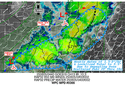
...Carolina Coast...
Inverted trough analyzed off the SC coast will continue to plague
the immediate coastal areas with the heaviest precip footprint
currently just offshore of CHS with a migration to the north.
Strong low-level convergence signature will remain over the
northern periphery of a weak surface reflection organizing over the
Southeast coast. A band of heavier rain will occur between CHS up
through MHX with the greatest opportunity for heavier rates and
flash flooding likely locked to the coastal plain and more prone
urban areas. PWATs running near climatological peak across that
area (2-2.2" expected) depicts a moisture rich profile capable of
locally enhanced rates and totals that could easily reach 2-3" with
isolated to 4" in a few of the harder hit areas. Right now, that
chance seems to be more north than what was alluded to earlier in
the D1 with places from Myrtle Beach through Wilmington to
Morehead City the more likely to see the heaviest rainfall. The
sandier soils will help keep the worst of the potential at bay, so
the threat is more relegated to the MRGL risk category when
assessing trends. As a result, the previous SLGT risk was dropped
with a MRGL across portions of the immediate SC and Southeastern NC
coast.
Kleebauer
Day 1 threat area:
www.wpc.ncep.noaa.gov/qpf/94epoints.txt
Excessive Rainfall Discussion
NWS Weather Prediction Center College Park MD
826 PM EDT Wed Jun 4 2025
Day 2
Valid 12Z Thu Jun 05 2025 - 12Z Fri Jun 06 2025
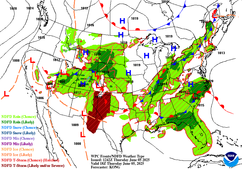
...THERE IS A SLIGHT RISK OF EXCESSIVE RAINFALL FOR PORTIONS OF
THE SOUTH-CENTRAL PLAINS AND COASTAL NORTH CAROLINA...
...2030z update...
A slight risk was introduced for much of the North Carolina coast
with this afternoon's update. Models have increased qpf magnitudes
and coverage through the Outer Banks and some inland areas where a
marginal risk is also in effect to account for any convective
bands that penetrate into eastern NC. Most notably, the Euro
trended faster with its axis of precipitation/convection along the
NC coast. Forecast details remain mostly the same. The marginal
over southwestern Texas was expanded south toward the Mexican
border.
Kebede
...Intermountain West to Central/Southern Plains...
Thursday/Day 2 should see a similar pattern as Wednesday/Day 1,
with a broad positively tilted trough axis across the West and
shortwaves moving through. Pacific moisture (continuing to be over
the 90th percentile for PWs, and as high as the 99th percentile,
per NAEFS) will stream northeastward just ahead of the trough to
produce scattered convection across the central Great Basin toward
the central Rockies, where the Marginal Risk has been maintained
(and adjusted to the latest data).
Farther east, an initial shortwave will force convection in the
southern High Plains tonight into Thursday morning, then a renewed
low-level jet (30-40 kts at 925-850mb) will push moisture and
instability a bit farther north into Oklahoma/Kansas Thursday
night. This will likely sustain convection (or perhaps reinitiate
convection from a remnant MCV) that originates in CO/NM, leading
to heavy rain rates (that potentially persist and repeat over the
same areas). While there continues to be spread in the guidance
regarding whether there are ultimately two separate areas of
convection (one near the TX Panhandle and Permian Basin and another
near the KS/OK border) or one more consolidated area of convection
(likely somewhere inbetween), have maintained and adjusted the
associated SLGT risk (which is centered near the highest ECENS 2"
and 3" exceedance probs). Further refinements are expected with the
addition of the remainder of the CAM suite later today (and could
result in higher confidence of upper-end SLGT probabilities, should
CAMs come into relatively good agreement).
...Ohio/Tennessee Valleys and Lower Great Lakes...
Moisture pooling along a meandering front may lead to locally heavy
rain across the Mid-Lower MS Valley and OH/TN Valleys toward the
Lower Great Lakes region. A Marginal Risk was adjusted eastward
across this region from prior cycles, owing to trends in the
placement of the frontal zone. Still considered a Marginal Risk
stretching into northern New England near/ahead of the front where
above normal moisture and instability are likely, but have judged
model QPFs remain not too heavy. There is likely a non-zero
probability for localized flash flooding, which will continue to be
monitored.
...Southeast/Carolina Coast...
A non-tropical low pressure system is forecast to be tracking just
onshore in the Carolinas on Thursday, and models continue to
indicate significant rainfall totals mainly just offshore in
association with tropical moisture. While this system is most
likely to remain frontal/baroclinic in nature, there is still a
low-end chance (near 10% per the NHC) of a tropical or sub-tropical
low consolidating within the persistent tropical convection offshore.
Even though the heaviest rainfall totals are forecast to stay
offshore, wraparound moisture is expected to stream into coastal
areas with PWs near the 95th percentile (per NAEFS). Have
maintained a MRGL risk for the new Day 2, owing to uncertainties
with regard to how things ultimately develop, but current ensemble
probs (available CAMs and GEFS/ECENS) suggest 2-3" areal averages
for the NC coast (which has the greatest chance of being locally
upgraded to a SLGT with subsequent updates). Farther west and south
of the low, lack of instability and focused low-level moisture
transport looks to limit rain rates and subsequent totals (though
lingering flooding may still be ongoing from D1 rainfall).
Churchill/Tate
Day 2 threat area:
www.wpc.ncep.noaa.gov/qpf/98epoints.txt
Excessive Rainfall Discussion
NWS Weather Prediction Center College Park MD
826 PM EDT Wed Jun 4 2025
Day 3
Valid 12Z Fri Jun 06 2025 - 12Z Sat Jun 07 2025
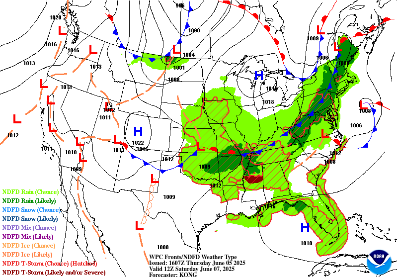
...THERE IS A SLIGHT RISK OF EXCESSIVE RAINFALL FOR MUCH OF
OKLAHOMA INTO NORTHERN ARKANSAS AND SOUTHERN MISSOURI...
...2030z update...
The inherited marginal risk area was maintained with little to no
adjustments made, though there continues to be the opportunities
for upgrades along the spine of the stationary front draped across
the Ohio Valley and Northeast. The slight risk over the Southern
Plains and Lower/Middle Mississippi Valley was expanded eastward
into northern Arkansas and southern Missouri. MCS(s) moving along
an instability pool of 1000-3000J/Kg and 1.5-2in. PWATs could
produce robust rainfall rates Friday afternoon/evening. Low FFGs
from recent rainfall and increased qpf/24h 1-2in exceedance
probabilities in today's 12z guidance support the expansion.
There's also a continued signal for a slight risk in the 12z 1-2
year 24hr ARI exceedance and UFVS first guess fields.
Kebede
...Southern Plains...
Convection looks to remain active in the Southern Plains from
overnight Thursday into Friday morning, fueled by a 30-40 kt low-
level jet and likely ongoing MCS(s). In addition, the trailing
frontal zone is unlikely to move much as the upper-level pattern
remains blocky. Models indicate that another shortwave could fuel
yet more organized convective coverage into Friday night, this time
originating from the northern stream and digging southeastward from
the central Rockies/High Plains. The LLJ should reinvigorate once
again, and this is a recipe for heavy rainfall with training and
repeating over many of the same areas a distinct possibility. While
there is a fair amount of spread in the global guidance at this
range with QPF output, the consensus cluster is pretty well
situated over central OK (with some solutions suggesting farther
eastward progress of high totals into portions of northwest AR and
southwest MO). Maintained the inherited SLGT risk over the best
ensemble signal (where 00z GEFS/ECENS 2" and 3" exceedance probs
overall quite well). As confidence increases, the SLGT risk region
may expand (with potential for a targeted Moderate upgrade in
subsequent outlooks, depending largely on how much rainfall
transpires on Thursday and how well QPF on Friday overlaps).
...MS/TN/OH Valleys into Great Lakes and Appalachians...
Moisture looks to continue to pool along a meandering front in
this blocky pattern, which may continue to lead to locally heavy
rain across the Lower-Middle MS Valley and OH/TN Valleys toward
the Lower Great Lakes region. The MRGL was maintained and adjusted,
and subsequent targeted SLGT(s) may be necessary with increasing
overall PWs and the potential for localized totals beginning to add
up from multiple days. In addition, expanded the inherited MRGL
risk eastward into much of the Appalachians, as models come into
better agreement that better moisture and subsequent convection
will start to move into those more sensitive areas.
Churchill
Day 3 threat area:
www.wpc.ncep.noaa.gov/qpf/99epoints.txt
Extended Forecast Discussion
NWS Weather Prediction Center College Park MD
256 PM EDT Wed Jun 4 2025
A frontal system will be working through the Northeast at the
start of the period Saturday, with above average moisture (likely
from the Gulf and Atlantic) and instability pooling along and ahead
of it. This should produce some convection possibly with heavy
rain rates over an inch per hour that could cause flash flooding
concerns over typically sensitive areas like terrain in the
Northeast. Thus a Marginal Risk is in place in the Day 4/Saturday
ERO in eastern New York into northern New England. This trend was
farther north than than the previous outlook showed.
This front will stretch back through the Lower Ohio/Tennessee
Valleys, Lower Mississippi Valley, and into the southern Plains.
Ample moisture and high instability is likely across this southern
tier with upper level support at the base of the trough. Rain and
thunderstorms are likely to be widespread with these parameters in
place. The Storm Prediction Center continues to show the potential
for severe weather Saturday across the south-central Plains east
into the Southeast. Meanwhile there is a threat for flash flooding
in much the same areas, but perhaps reaching the southern
Appalachians. The Day 4/Saturday ERO indicates a Marginal Risk,
with an embedded Slight along the Red River into the Ark-La-Tex
where convection may be ongoing Saturday morning, with another
round Saturday night. This Slight was shifted just a bit south
compared to the previous issuance per newer guidance. Did think it
was best to break the Day 4 Marginal Risk that previously stretched
across the central/northern Appalachians and remove those areas,
as rain there is generally expected to be less than half an inch
and not cause flash flooding concerns.
Into Sunday, the front will progress more quickly offshore of the
Northeast, but linger across the southern tier, pressing slightly
southward especially in the Southeast. A Day 5 Marginal Risk is in
place across the Lower Mississippi Valley and Southeast, with an
expansion back west across the southern Plains where models
indicate yet another MCS. Will continue to monitor if/how heavy
rain overlaps with previous days, with the ground being more
sensitive in areas where there has already been heavy rain ,
leading to enhanced flooding concerns. In other words, eventual
upgrades to Slight Risks are certainly possible especially where
antecedent conditions allow for it, and if/where models converge on
placement of heavy rain rates.
Meanwhile, another frontal system will track across the
Midwest/Great Lakes for some modest rain there over the weekend,
reaching the Northeast by Monday and Tuesday. The current forecast
continues to show the leading front dissipating while this
secondary front becomes dominant. The second front settling south
will once again promote rain and thunderstorms across the southern
Plains and Southeast through the first half of next week as the
moisture and instability lingers.
The trough aloft centered in the east-central U.S. will generally
lead to average to slightly below average temperatures there.
However, southern Texas will be a few degrees above already hot
averages, reaching well into the 100s with heat indices possibly
above 110F. But the largest temperature anomalies will be across
the Northwest U.S. through the weekend into early next week
underneath mean upper ridging. Temperatures are forecast to be 15
to 25 degrees above average across much of the Northwest, with
highs reaching well into the 90s in interior areas. Even cities
like Seattle look to reach the mid to upper 80s. Above normal
temperatures will stretch into the central Great Basin, and the
Desert Southwest can expect temperatures well into the 100s to 110
degrees. For safety information, see weather.gov/heat.
Tate


