Excessive Rainfall Discussion
NWS Weather Prediction Center College Park MD
259 PM EDT Fri May 30 2025
Day 1
Valid 16Z Fri May 30 2025 - 12Z Sat May 31 2025
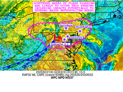
...THERE IS A SLIGHT RISK OF EXCESSIVE RAINFALL FOR PORTIONS OF THE
OHIO VALLEY THROUGH THE MID-ATLANTIC STATES...
The regional satellite imagery this morning shows a potent upper
low moving across Ohio, and it is this feature which will help
manifest the flash flood risk from the Ohio Valley into the Mid-
Atlantic and Northeast today. As this low tracks northeast today,
it will move along a baroclinic zone/surface front, helping to
spawn a surface wave of low pressure. This low will track E/NE
along the boundary, moving from eastern KY this morning to western
New England by Saturday morning.
As this low tracks northeast, it will encounter increasingly
favorable thermodynamics, into which forcing will become more
intense, leading to both an expansion and intensification of
convection. The simulated reflectivity from the available CAMs are
relatively similar with widespread showers and thunderstorms
blossoming ahead of the low, and becoming most impressive from
Maryland and points northeast into western New England. This is
supported by more robust thermodynamics being drawn northward,
characterized by a ribbon of elevated PWs of 1.25 to 1.5 inches,
highest east of I-95, and MUCAPE above 1000 J/kg. This will support
rainfall rates for which the HREF indicates have a high a moderate
to high chance (40-70%) of exceeding 1"/hr, and 10-20% chance of
exceeding 2"/hr, enhanced by increasingly impressive synoptic
ascent aided by the LLJ and favorable LFQ of a strengthening jet
streak.
In general, convection which develops downstream of the low will
be progressive on 0-6km mean winds of 20-30 kts. However, aligned
Corfidi vectors suggest some short-term training is possible which
could lengthen these rain rates, or result in repeating rounds in
some areas. Additionally, as bulk shear surges to 40-50 kts,
storms will likely organize into clusters, with an even better
chance for some training along I-95 from Washington, D.C. into
western New England. The simulated reflectivity suggests as the
surface low wraps up a dry slot will pivot in behind the primary
clusters, somewhat reducing the excessive rain risk, but this is
lower confidence, and a stripe of heavy rain of 1-3" is expected,
with locally more than 4" (or even 5") possible from Maryland
through New York as reflected by both the NBMv5.0 and the HREF. The
inherited SLGT risk was modified only slightly for recent
guidance, and expanded a bit northeast into New England.
Weiss
Day 1 threat area:
www.wpc.ncep.noaa.gov/qpf/94epoints.txt
Excessive Rainfall Discussion
NWS Weather Prediction Center College Park MD
259 PM EDT Fri May 30 2025
Day 2
Valid 12Z Sat May 31 2025 - 12Z Sun Jun 01 2025
...THERE IS A SLIGHT RISK OF EXCESSIVE RAINFALL OVER PORTIONS OF
NEW ENGLAND...
...New England...
Surface low pressure deepening in response to favorable ascent
from the RRQ of an upper jet streak, height falls, and residual
baroclinicity along a cold front. This surface low will intensify
as it tracks northward through New England, while the low-level
flow downstream advects greater moisture and instability northward.
Despite the impressive system, thermodynamics are progged to remain
modest as reflected by forecast PWs of 1-1.25 inches, around the
75th percentile according to the SPC sounding climatology, and
MUCAPE of around 250 J/kg. This will support generally modest
rainfall rates of 0.5"/hr, but locally higher is possible,
especially within any organized convection on 30-35 kts of bulk
shear. Storms will generally track northward at around 25 kts, but
some short term training is possible which could additionally
enhance the duration of any higher rainfall rates. This will
produce swaths of 1-2" of rain as reflected by modest ensemble
cluster probabilities, with a local maxima progged across VT where
the deformation axis on the back side of this low will pivot,
leading to longer duration of rainfall, despite more modest
rainfall rates through Saturday evening, atop slightly wetter soils
and sensitive terrain. After coordination with WFO BTV, opted to
include a targeted slight risk where the greatest potential for
persistent moderate to heavy rain overlaps the sensitive terrain,
and where the highest HREF probabilities for more than 3" of rain
exist.
...Southern Plains...
Expansive trough centered over the Great Lakes will lead to
lowering heights over the Plains, with an embedded but potent shortwave
progged to track southward from Nebraska to Texas Saturday
evening/night. This shortwave will impinge into a destabilizing
environment reflected by a corridor of 1000 J/kg or more MUCAPE,
collocated with PWs surging to around 1.25 inches as the SW LLJ
increases to to 20-25 kts Saturday evening. Thunderstorms are
expected to blossom along a decaying cold front being pushed south
by this shortwave, with upscale growth and organization possible
thanks to 40-50 kts of bulk shear. Rainfall rates of 1-2"/hr are
progged within this maturing convection, leading to locally as much
as 3" of rain (10-20% chance). This could produce isolated
instances of flash flooding despite the general progressive nature
of this convection.
Weiss
Day 2 threat area:
www.wpc.ncep.noaa.gov/qpf/98epoints.txt
Excessive Rainfall Discussion
NWS Weather Prediction Center College Park MD
259 PM EDT Fri May 30 2025
Day 3
Valid 12Z Sun Jun 01 2025 - 12Z Mon Jun 02 2025
...THERE IS A MARGINAL RISK OF EXCESSIVE RAINFALL OVER PORTIONS OF
THE SOUTHWEST...
The persistent closed upper level low off of the Baja Peninsula
will begin to fill and slowly eject northeast on Sunday, reaching
the low Deserts of CA and Arizona by the end of the forecast
period. As this feature pivots northeast, it will produce subtle
height falls, but more impressively draw tropical moisture
northward as reflected by NAEFS PWs above 1.25 inches, or above the
99.5th percentile surging into AZ/CA/NV late D3. This will overlap
at least modest instability, potentially as high as 250-500 J/kg,
to support increasing convective coverage later D3.
There remains some uncertainty into the timing of development of
showers due to what could be enhanced cloud cover reflected by high
700-300mb RH. This may slow destabilization and reduce convective
coverage, which explains why ECENS/GEFS probabilities for even 1"
of rainfall are less than 5%. However, with the impressive PW
anomalies in place, once showers to develop they could contain rain
rates of above 0.5"/hr, which will support at least an isolated
potential for flash flooding where storms move most slowly beneath
the upper low.
Weiss
Day 3 threat area:
www.wpc.ncep.noaa.gov/qpf/99epoints.txt
Extended Forecast Discussion
NWS Weather Prediction Center College Park MD
223 PM EDT Fri May 30 2025
For the Mon-Tues period, a heavy rain threat exists along/ahead of
a frontal system moving through/into the Northern and Central
Plains to the Midwest/Mid-MS Valley. A Marginal Risk of excessive
rainfall is maintained through these areas. The front will continue
eastward and southward along with the heavy rain threat (into the
Southern Plains/Lower MS Valley/Mid-South) by the end of next week.
Drier conditions are expected along both the East and West Coasts
with the exception of Florida which may see more appreciable
rainfall over the central/southern portions in the vicinity of a
dying oceanic boundary. Some mountain areas of Wyoming may see a
few inches of snow as colder air comes in behind the front.
Temperatures will warm over the central/eastern US as summer makes
a decisive start/return in stark contrast to the stretch of cool
temperatures the past week or so. Highs into the 80s/90s will pose
a Moderate HeatRisk threat to some regions -- take precautions in
the heat especially if you are not yet acclimated to the warmer
temperatures. Farther south, areas of South Texas will see more
days of highs into the upper 90s and low 100s with low
probabilities (20-40%) of reaching heat index values of at least
110F. Much cooler temperatures will follow behind the cold front,
starting in the Rockies on Monday then into the Plains thereafter,
but moderating with time. Much of the West will see near to
slightly above normal temperatures, especially later in the week.
Fracasso


