Excessive Rainfall Discussion
NWS Weather Prediction Center College Park MD
846 PM EDT Sat Jun 7 2025
Day 1
Valid 01Z Sun Jun 08 2025 - 12Z Sun Jun 08 2025
...THERE IS A SLIGHT RISK OF EXCESSIVE RAINFALL IN THE OHIO RIVER
VALLEY AND MID-SOUTH INTO THE SOUTHEAST...
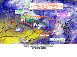
01Z Update...
...Midwest and Central Appalachians...
Thunderstorms will continue develop in advance of an eastward
moving wave currently along the MO/IL border. This activity should
mainly form along the warm front currently extending from StL
through southern IN and organize a bit in the warm air advection
regime. PW increases behind the front to around 1.75", above the
90th percentile for early June, along with tall, skinny CAPE
profiles per model soundings that will make for efficient, low-
topped convection and scattered flash flood events. Of particular
concern will be the potential for flash flooding overnight from
central IN along the mid-upper OH Valley through WV. Southwest
low- level inflow increases over the terrain in the very moist
environment with the right entrance region of an upper level jet
streak providing divergence aloft. Locally significant flash
flooding will be possible given the terrain and relatively wet
antecedent conditions of the Slight Risk area.
...Mid-South through Southeast...
Forward propagating MCS pushes east over SC this evening with fast
motion. The leading cells that developed ahead of the line when it
was over GA are not occurring as much over SC, so the associated
flash flood threat is low overnight.
The next line of activity has developed across south-central AR and
is moving close to its orientation axis, causing repeating cells.
This will continue until enough cold pool can develop to begin a
propagation southeast into LA and over north-central MS/AL which
continues rest of the overnight. Despite dry antecedent conditions
and high FFG, the Slight Risk is maintained for potential for 2-4"
rainfall with high hourly rates and potential scattered instances
of flash flooding.
...Southern Plains...
Third consecutive night of supercells from the south-central High
Plains developing and shifting southeast. Expanded a Marginal Risk
from North Texas to these cells based on current motion and CAM
guidance like recent runs of the RRFS which maintain this activity
through tonight. This swath is mainly between the heaviest rain
from last night, but there is an isolated flash flood threat as
this activity propagates southeast.
...Northeast...
Low pressure has shifted well east of New England bringing rainfall
with it. Some heavy rain remains along the front over Long Island,
though the rates are not excessive. The EROs in the Northeast have
been removed.
Lamers/Jackson
Day 1 threat area:
www.wpc.ncep.noaa.gov/qpf/94epoints.txt
Excessive Rainfall Discussion
NWS Weather Prediction Center College Park MD
408 AM EDT Sun Jun 8 2025
Day 1
Valid 12Z Sun Jun 08 2025 - 12Z Mon Jun 09 2025
...THERE IS A SLIGHT RISK OF EXCESSIVE RAINFALL FOR PORTIONS OF THE
SOUTHERN PLAINS AND MID-ATLANTIC...
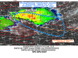
...Southern Plains...
A southward moving upper level shortwave rounding the western
periphery of a potent upper level low will support a strong cold
front tracking south across the central Plains this afternoon and
evening. Meanwhile, ample Gulf moisture in place across Texas and
along the Gulf moisture will advect northward ahead of the cold
front, drawn to the front my the pressure differential. The result
of these clashing air masses will be widespread convective
development, partially aided further by the dry line, across the
Panhandles and western Oklahoma mid-to-late afternoon. In addition
to significant severe potential with the abundant shear in the area
from these clashing boundaries, the storms will be moving over a
very sensitive area for soil moisture due to numerous rounds of
recent rainfall across the Panhandles and the Red River Valley.
This supports the continuance of the Slight Risk across much of the
region, including a higher-end Slight in and around the Wichita
Falls, TX area. The higher-end risk is due in part to some CAMs
agreement for additional training and cell mergers in the early
evening.
As is fairly typical of areas of strong thunderstorms and
supercells, their merger into a single area of storms should
accompany a faster forward speed, which should gradually decrease
the flash flooding potential across the region into the overnight
hours tonight. There is much greater disagreement as to whether
additional shower and thunderstorm activity will develop behind the
area of storms, which are very likely to set up along a preexisting
cold-pool boundary. The coverage and intensity of the storms is
highly uncertain, but a preponderance of the guidance suggesting
the storms will develop and track southeastward over many of the
same areas, particularly on the Texas side of the state line, could
support a higher flash flooding threat. While the issuance of an
upgraded Moderate Risk for these areas is not out of the question,
it will likely take seeing the whites of the storms' eyes to have
the confidence for such an upgrade. This will also be highly
dependent on how the storms behave with the initial MCS development
over these areas.
...Mid-Atlantic...
A developing upper level shortwave will team up with a surface low
and associated showers and a few storms early this morning across
the Mid-Atlantic. With daytime heating and advection of additional
moisture and instability, expect the rainfall across the area to
become increasingly convective across the Slight Risk area. These
storms will be capable of heavy rainfall with potential for widely
scattered flash flooding. This portion of the Mid-Atlantic is also
very sensitive to heavy rainfall due to recent heavy rains over the
past week or so. Topographic concerns will also be present as the
mountains funnel any heavy rain quickly into the adjacent river
valleys. Expect the heaviest rainfall to occur south and west of
the warm front associated with the surface low. There is
considerable uncertainty as to how far north and east the warm
front will get, as the surface low will be weakening due to
interactions with the mountains. Thus, by this afternoon the
instability and moisture supporting the storms will be the primary
forcing supporting their capability of producing heavy rain.
Given these aforementioned uncertainties, the inherited Slight Risk
area is largely the same. The biggest change with this update was
to expand the Slight Risk northwestward to include the Pittsburgh
metro area. The heaviest rains are likely to fall along a northwest
to southeast oriented line from Pittsburgh to the Hampton Roads
area of southeast Virginia. There is significant uncertainty around
the DC metro area due to distance from the greatest forcing and how
far north and east the warm front can get, with the most likely
scenario for the DMV area to be missed by the heaviest rains, which
stay south and west. However, given the sensitivities and urban
concerns requiring less rain to produce flash flooding, the Slight
Risk was left in effect for this update in the DC area. Once again
the Virginia suburbs will have the greatest chance of seeing the
most consistent heavy rains.
Wegman
Day 1 threat area:
www.wpc.ncep.noaa.gov/qpf/94epoints.txt
Excessive Rainfall Discussion
NWS Weather Prediction Center College Park MD
408 AM EDT Sun Jun 8 2025
Day 2
Valid 12Z Mon Jun 09 2025 - 12Z Tue Jun 10 2025
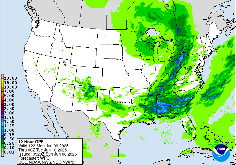
...THERE IS A SLIGHT RISK OF EXCESSIVE RAINFALL FOR THE UPPER OHIO
VALLEY THROUGH CENTRAL NEW YORK...
...Upper Ohio Valley through Central New York...
A potent upper level low over the Great Lakes on Monday will become
increasingly negatively tilted through the period as a shortwave
and the low itself begin the process of rejoining the jet stream.
Thus, expect the upper low and any flow around it over the
Northeast to become more southwesterly with time. At the surface, a
strong cold front will rapidly sweep across the Midwest. That front
will be slower-moving in northern areas as the upper level pattern
becomes more amplified. Thus, the storms that will develop ahead of
the cold front will be slower moving from Pennsylvania north into
New York, supporting a higher likelihood for training. Ahead of
this cold front, Gulf moisture will be drawn northeastward,
supported by the increasing upper level forcing as the trough
becomes more negatively tilted by Monday evening.
Longer-range CAMs guidance shows multiple rounds of storms tracking
across Pennsylvania and New York through the period, being driven
by different impulses of upper level energy as those shortwave
troughs track more south to north with time. While duration of the
heavier rains will be lesser on Monday across WV, MD, and VA,
expected heavy rainfall from the Day 1/Sunday period in this area
should lower the FFGs in the area by the Day 2/Monday period. Thus,
the Slight Risk includes areas expecting less rainfall on Monday
afternoon. Meanwhile in PA and NY, sensitive soils will still be
present, as well as topographic concerns, so the higher threat for
flash flooding will be into western and central NY.
...Southeast...
Across the Southeast, expect multiple rounds of storms to cross
Mississippi, Alabama, and Georgia through the period. The storms
will be supported by periodic passages of shortwave disturbances in
the upper levels, but they will be much further in between
disturbances as compared with areas further north, as the Southeast
will be further from the greatest forcing associated with the low
over the Great Lakes. Partially offsetting this will be the
proximity to the Gulf, which will allow for there to be far more
moisture available for the storms as compared with areas further
north. Soils in this area are around average for moisture content
as there has been some time for the soils to dry out from past
rainfall events. This has allowed FFGs to recover quite a bit, and
the high FFGs will play a big role at tampering the severity and
frequency of instances of flash flooding due to the heavy rains.
Thus, for now, the area remains in a Marginal risk, but will be
evaluated with future updates for upgrade potential.
...Texas...
Significant uncertainty remains in the potential for flash flooding
across Texas on Monday. The cold front impacting much of north
Texas on Sunday will push further south, turning the predominant
flow out of the north across the northern half of the state. This
should allow for advection of drier air. Ample solar heating will
still promote the development of instability, as well as any
evapotranspiration in the area. Thus, expect at least some shower
and thunderstorm activity again on Monday, albeit more likely on
Monday night. Given the sensitivities from heavy rains in this
area, the lesser coverage and duration of storms may still be
enough to eventually need a targeted Slight Risk upgrade between
now and Monday afternoon, but the confidence is not quite there
yet.
Wegman
Day 2 threat area:
www.wpc.ncep.noaa.gov/qpf/98epoints.txt
Excessive Rainfall Discussion
NWS Weather Prediction Center College Park MD
408 AM EDT Sun Jun 8 2025
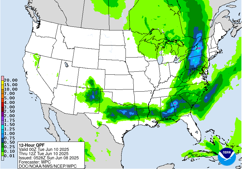
Day 3
Valid 12Z Tue Jun 10 2025 - 12Z Wed Jun 11 2025
...THERE IS A SLIGHT RISK OF EXCESSIVE RAINFALL FOR MUCH OF WEST
TEXAS AND SOUTHEASTERN NEW MEXICO...
...West Texas and New Mexico...
After potentially leftover convection in the early morning hours of
Tuesday from Monday night's convection, much of the day across the
Slight Risk area will be mostly dry. With peak solar heating in the
late afternoon, however, a strengthening subtropical shortwave
ejecting out of the Southwest will interact with the plentiful Gulf
moisture already in place across west Texas. This will result in
widespread convective development Tuesday evening. There is
significant uncertainty however with the nature, coverage, and
strength of the thunderstorms, as well as where and when they will
impact any one area. Given that, and the spread in the guidance,
the Slight Risk was expanded westward into New Mexico to account
for potential development off the Sacramento Mountains, and any dry
line convection. Regardless, there remains enough agreement that
given plentiful recent rainfall and convective activity across West
Texas, this new round of rain should result in widely scattered
instances of flash flooding. This may be start of another period of
daily thunderstorms in this area through the mid-range.
...New England...
Convective activity in this region will be ongoing at the start of
the period and continue through the day as Atlantic moisture is
drawn northward ahead of a NNE moving upper level trough that will
be rejoining the jet stream. The rainfall should be largely over in
New England by Tuesday evening. Given most of the day the rainfall
will be in the cooler, more stable part of the day, expect lesser
rainfall rates. Thus, the inherited Marginal Risk was left
unchanged with this update.
Wegman
Day 3 threat area:
www.wpc.ncep.noaa.gov/qpf/99epoints.txt
Extended Forecast Discussion
NWS Weather Prediction Center College Park MD
226 AM EDT Sun Jun 8 2025
A trailing frontal boundary draped generally west to east across
the South will continue to provide focus for numerous showers and
thunderstorms through most of next week. Guidance continues to
converge of central Texas into Oklahoma for multiple days of heavy
rainfall, with parts of this area already primed from recent
rainfall. Accordingly, the Days 4 and 5 Excessive Rainfall Outlooks
(valid Wednesday and Thursday) show slight risk areas across this
region. Intentionally kept the slight risks (and surrounding
marginal risks) broad given some lingering uncertainties in exactly
where possible convective complexes track and the location of
heaviest rain. If the forecast materializes though, it is possible
a moderate risk area may be needed at some point in the future. By
Thursday and Friday, this front should lift north pulling the
heavier rains out of Texas, but continuing for parts of Oklahoma
into the middle Mississippi Valley, eventually moving into the Ohio
Valley and East next weekend.
A shortwave interacting with a frontal boundary across the
northern tier will bring showers and storms across parts of the
northern Rockies into the Upper Midwest. Moisture anomalies should
be above the 90th percentile in especially Montana, supporting a
Marginal Risk on the Wednesday and Thursday ERO. Additionally,
convection is likely to move through the north- central U.S. along
the cusp of the instability gradient and thus the Marginal Risk
also extends east into the Upper Midwest.
A heat wave during the short range period over the West should
moderate by the start of the medium range period, though above
normal temperatures may continue across the West through the
period. Daytime highs generally could be 5 to locally 15 degrees
above normal. Otherwise, the rest of the country looks near normal
or within a few degrees of normal depending on quick systems moving
through.
Santorelli


