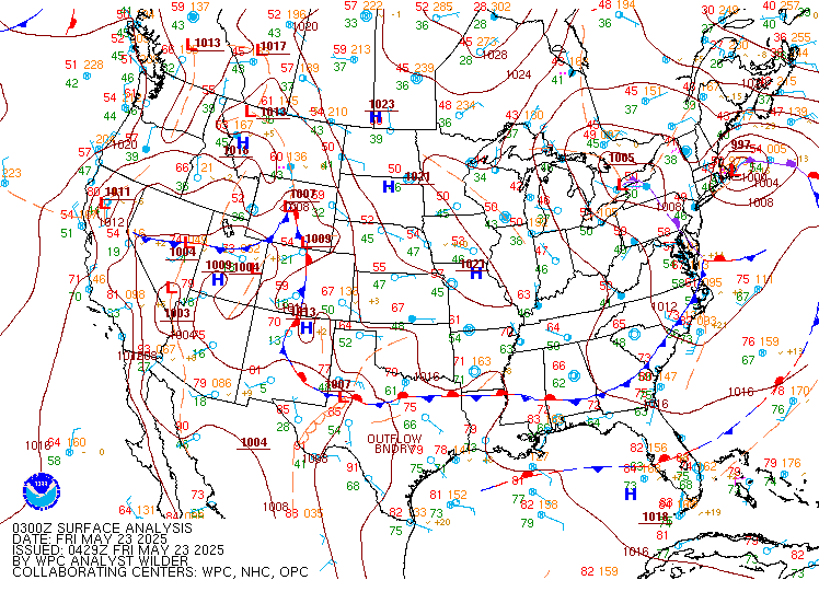
Excessive Rainfall Discussion
NWS Weather Prediction Center College Park MD
847 PM EDT Fri May 23 2025
Day 1
Valid 01Z Sat May 24 2025 - 12Z Sat May 24 2025
...THERE IS A SLIGHT RISK OF EXCESSIVE RAINFALL FROM SOUTHEASTERN
KANSAS AND NORTHEASTERN OKLAHOMA INTO THE OZARKS...
...01Z Update...
The focus of attention for heavy rainfall remains on parts of the
Plains to the Mid-South later tonight. Convection developing over
the plains of eastern Colorado will continue to build
southeastward and grow upscale in both areal coverage and
intensity. HREF 18Z neighborhood probabilities continued to
maximize in southwest Missouri and parts of adjoining states after
24/07Z with values approaching 20 percent for 2 inch per hour rates
during the overnight hours. The placement of these higher
probabilities fit nicely into the part of the Slight Risk area of
the previously- issued ERO where confidence was highest. As a
result...few changes other than a minor westward expansion of the
Marginal risk area were needed.
With convection over the southeast Florida peninsula on the
decline...removed the Marginal risk area there.
Bann
...Previous Excessive Rainfall Discussion...
...Kansas, Oklahoma, Missouri, Arkansas...
There remains a good model signal for the development of heavy
rainfall later today, in what is expected to be the first of
several rounds impacting the region over the next few days.
The synoptic pattern will evolve today into one that will support
heavy rain within periods of organized convection/MCS beginning
tonight. This will be in response to the central part of the CONUS
being sandwiched between an elongated trough to the northeast and a
building ridge over the Four Corners, which leaves broad W/NW flow
across the area. Within this flow, ascent will occur through
periodic impulses moving through the flow combined with the RRQ of
a jet streak aloft. The resultant frontogenesis from the RRQ of the
jet streak will efficiently overlap a warm front wavering in the
area, providing additional lift, which will then be enhanced by
isentropic ascent of the LLJ atop this front.
Forcing will be pronounced, and will act upon favorable thermodynamics,
which will become increasingly robust the latter half of today and
tonight. This will occur as the impressively broad 850mb LLJ
emerges from the Gulf and surges to 40+ kts, angling orthogonally
into the warm front. This will produce strong moisture convergence
as reflected by the moisture transport vectors, and resupply
elevated CAPE of 3000 J/kg northward into the Plains. As convection
blossoms this evening, generally after around 04Z, it will expand
rapidly and organize thanks to 40-50 kts of bulk shear. This will
result in clusters of storms, potentially growing upscale into an
MCS, and training of echoes is likely due to aligned flow to the
warm front. There continues to be some uncertainty into how quickly
the convection will grow into an MCS allowing it to push faster to
the southeast towards daybreak Saturday, but until that happens,
some upstream growth to the NW is expected which will prolong
training of echoes. With a high probability for rain rates
exceeding 2"/hr, any training could lead to rainfall of 2-5", with
locally higher amounts possible (10-20% chance), especially near
the MO/KS/AR/OK intersection.
Another fly-in-the-ointment for the risk area is how elevated
convection north of the warm front, especially early tonight, will
impact the progression SW. There are a few high-res CAMs, and
several global models, that suggest an outflow boundary will be
pushed south more into Oklahoma tonight, which will be aided by
residual boundaries from any dry line convection moving east, and
the front itself. This could result in a bi-modal distribution to
rainfall, and a secondary maxima of flash flood risk across eastern
OK. While confidence is higher in the isentropic/elevated heavy
rain risk farther north, the SLGT risk was tailored a bit SW from
inherited to account for this potential. Otherwise, the inherited
risk areas were modified only cosmetically for recent guidance,
primarily being pulled NW (the MRGL risk area) more into KS for
backbuilding convection during the development stage.
...South Florida...
A weakening front across South Florida will serve as a focus for
slow moving thunderstorms once again today, drifting east to the
Gold Coast through the aftn/eve. This front and a lingering tail of
an upper jet streak will provide synoptic lift into favorable
thermodynamics characterized by PWs of 1.75 to 2.00 inches, and
SBCAPE above 2000 J/kg. This overlap will support rainfall rates
within thunderstorms for which the HREF indicates has a 40% chance
of exceeding 2"/hr, and the 15-min HRRR suggests brief rainfall
intensity of 4"/hr possible. Where these storms slow/stall,
primarily along the southeast coast where they interact with the
sea breeze, this could result in spots of 3-5" of rainfall. Should
this rain occur atop urban areas or over locations that have
received heavy rainfall the past 48-hrs, isolated flash flood
instances could result, so the MRGL risk was maintained.
Weiss
Day 1 threat area:
www.wpc.ncep.noaa.gov/qpf/94epoints.txt
Excessive Rainfall Discussion
NWS Weather Prediction Center College Park MD
847 PM EDT Fri May 23 2025
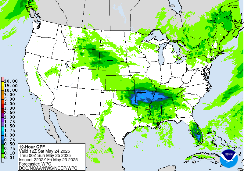
Day 2
Valid 12Z Sat May 24 2025 - 12Z Sun May 25 2025
...THERE IS A SLIGHT RISK OF EXCESSIVE RAINFALL FROM SOUTHEASTERN
KANSAS and NORTHEASTERN OKLAHOMA INTO THE OZARKS...
...Central/Southern Plains to Ozarks...
The period will begin with decaying convection from what is
expected to be a pronounced MCS moving across the region overnight
tonight into Saturday morning. As this decays and drifts southward,
it will leave lingering boundaries across the region. Exactly where
these boundaries track is uncertain, but each one will be critical
to redeveloping convection later Saturday.
Otherwise, the synoptic setup continues to look favorable for
another round of heavy rainfall within organized convection/MCS
Saturday night, especially after 03Z or so. The placement of this
remains uncertain as the warm front will be meandering, and likely
influenced by residual convective boundaries pushing it subtly
south. At the same time, the mid-level ridge over the Four Corners
will at least drift eastward, causing some bulging of mid-level
thicknesses across the High Plains, and somewhat offsetting the
southward advance of the front itself. It is not possible to
decipher exactly where the boundary will be when convection
initiates with the onset of the robust LLJ Saturday night (SW 850mb
winds above 40 kts), but it will again be a focus for renewed
thunderstorms as PWs and MUCAPE surge to 1.75 inches and 3000 J/kg,
respectively. The accompanying impressive moisture flux will help
fuel convective development, and as bulk shear remains above 40
kts, thunderstorms will again quickly intensify and grow upscale
into a new MCS Saturday night. Training and backbuilding of echoes
with rainfall rates 1-2+"/hr are expected, leading to total
rainfall of 3-5" in some areas.
Considered a targeted MDT risk due to potential overlap of this
impressive rainfall atop soils that will be primed from anticipated
heavy rain on D1. However, the high-res CAMs and globals have
shifted just far enough south (suggesting the OFB will win out over
the slow ridge build) to preclude a perfect overlap of rainfall
footprints. After coordination with the affected WFOs, opted to
instead shift the SLGT risk southward a bit and leave room for a
potential upgrade with later updates should confidence in MCS
placement become more certain.
...Central High Plains...
Mid-level trough amplifying across the Great Basin will yield
downstream divergence into the High Plains on Saturday. This will
occur into an environment that will become increasingly moist and
unstable as 850mb flow emerging from the Gulf carries moisture and
instability northward into NE/SD/WY, and upslopes into the region.
The guidance has trended a bit more robust with rainfall across
this area on Saturday, as convection potentially becomes widespread
within PWs that are progged to exceed the 90th percentile
according to NAEFS ensemble tables. Rainfall rate probabilities
from the HREF and REFS both feature a low end risk (10-20%) for
brief 1"/hr intensity, and cells may repeat from west to east
through the evening, leading to rainfall that may exceed 2" in a
few locations. The signal is modest, and after coordination with
NWC there appears to be limited NWM signal as well, so no risk area
was introduced at this time. However, a MRGL risk may be needed
with future updates, especially if the focus translates a bit
farther north into wetter antecedent soils.
Weiss
Day 2 threat area:
www.wpc.ncep.noaa.gov/qpf/98epoints.txt
Excessive Rainfall Discussion
NWS Weather Prediction Center College Park MD
847 PM EDT Fri May 23 2025
Day 3
Valid 12Z Sun May 25 2025 - 12Z Mon May 26 2025
...THERE IS A MODERATE RISK OF EXCESSIVE RAINFALL FROM
SOUTHEASTERN KANSAS and NORTHEASTERN OKLAHOMA INTO THE OZARKS...
Rinse and repeat for D3 as the pattern remains stagnant and
supportive of yet another round of heavy rain due to repeating
thunderstorms and an MCS, especially the latter half of D3. This
will produce heavy rainfall on top of soils that will likely be
quite saturated (NASA SPoRT 40cm soil moisture forecast above the
98th percentile) from heavy rain anticipated on D1 and D2.
For Sunday, despite still some latitudinal differences in the
placement of the heavy rainfall due to uncertainty in the warm
frontal location, influence of any residual convective boundaries
from prior thunderstorms, and some eastward translation of the
mid-level ridge, the risk for flash flooding remains elevated. This
is because renewed convection beneath a shortwave moving across the
Southern Plains Sunday evening/night will again help generate and
focus thunderstorms. The environment will remain extremely
favorable for heavy rain, with PWs progged by NAEFS to exceed the
97th percentile late D3 as the renewed 850mb LLJ surges moisture
out of the Gulf and into the boundary.
The biggest difference between D3 and D1/D2 is that the guidance
suggests convection will blossom a bit farther SW than previous
days, but with uncertainty continuing, the MDT risk was adjusted
only slightly near the MO/KS/AR/OK borders where heavy rain is
possible all of the next 3 days. Farther SW into OK and even beyond
the Red River Valley into TX, some southward advancement of forcing
could produce heavy rainfall, so the SLGT risk was expanded into
this region as well where GEFS and ECENS probabilities are at least
modest for 3"/24 hrs, although the highest probabilities remain
farther to the NE within the MDT risk contour. While the latest CSU
first guess field driven by the UFVS does not suggest a MDT risk,
it is likely suffering from not recognizing the D1 and D2
antecedent rainfall, so after coordination with the WFOs the MDT
risk was tailored only slightly and maintained for potentially
considerable flash flooding, despite some future adjustments to the
position likely.
Weiss
Day 3 threat area:
www.wpc.ncep.noaa.gov/qpf/99epoints.txt
Extended Forecast Discussion
NWS Weather Prediction Center College Park MD
258 PM EDT Fri May 23 2025
A wet and wavy west-east oriented front will be in place over the
South on Memorial Day. Plentiful moisture and high instability will
fuel numerous showers and thunderstorms that may result in heavy
rain. Rainfall in the short term period will likely prime soils in
the South ahead of Memorial Day and could increase the threat of
flash flooding. The Day 4 (Monday/Memorial Day) Excessive Rainfall
Outlook (ERO) depicts a broad Marginal Risk (level 1/4) area across
portions of the southern Plains, Mid/Lower Mississippi Valley, and
Tennessee Valley with an embedded Slight Risk (level 2/4) area
from stretching from Nashville, Tennessee to Dallas, Texas. By
Tuesday and Wednesday, the main low along the frontal system should
progress east, bringing localized heavy rain to the Mid-Atlantic,
while the trailing front lingers across the South. The Day 5 ERO
depicts a Marginal Risk (level 1/4) for this elongated threat area
given still deep moisture and upper level support.
Elsewhere, moderate precipitation chances will extend from the
central Rockies to the northern and central Plains as the initial
upper level shortwave cuts trough the West early next week, and
some late season snow may be possible in the highest peaks of the
central Rockies as well. A stationary front curling back into the
southern/central Rockies and High Plains could help produce
scattered convection there next week as well. Meanwhile, two swift-
moving fronts moving through the Pacific Northwest could allow for
light to moderate precipitation, and summertime scattered storms
are also likely across the Florida Peninsula.
Hot weather will linger on Monday in South Texas where high
temperatures will reach the 90s and low 100s. Meanwhile, cooler
than normal temperatures by 10 to 20 degrees will take hold over
the north-Central and Eastern U.S. Monday into Tuesday underneath
upper troughing. Temperatures should gradually moderate closer to
normal as next week progresses. In the West, a building upper ridge
will lead to warmer than average temperatures by 10 to 20 degrees
during the second half of next week, and hazardous heat may develop
over the California Central Valley by next weekend.
Dolan/Schichtel


