Excessive Rainfall Discussion
NWS Weather Prediction Center College Park MD
847 PM EDT Fri May 23 2025
Day 1
Valid 01Z Sat May 24 2025 - 12Z Sat May 24 2025
...THERE IS A SLIGHT RISK OF EXCESSIVE RAINFALL FROM SOUTHEASTERN
KANSAS AND NORTHEASTERN OKLAHOMA INTO THE OZARKS...
...01Z Update...
The focus of attention for heavy rainfall remains on parts of the
Plains to the Mid-South later tonight. Convection developing over
the plains of eastern Colorado will continue to build
southeastward and grow upscale in both areal coverage and
intensity. HREF 18Z neighborhood probabilities continued to
maximize in southwest Missouri and parts of adjoining states after
24/07Z with values approaching 20 percent for 2 inch per hour rates
during the overnight hours. The placement of these higher
probabilities fit nicely into the part of the Slight Risk area of
the previously- issued ERO where confidence was highest. As a
result...few changes other than a minor westward expansion of the
Marginal risk area were needed.
With convection over the southeast Florida peninsula on the
decline...removed the Marginal risk area there.
Bann
...Previous Excessive Rainfall Discussion...
...Kansas, Oklahoma, Missouri, Arkansas...
There remains a good model signal for the development of heavy
rainfall later today, in what is expected to be the first of
several rounds impacting the region over the next few days.
The synoptic pattern will evolve today into one that will support
heavy rain within periods of organized convection/MCS beginning
tonight. This will be in response to the central part of the CONUS
being sandwiched between an elongated trough to the northeast and a
building ridge over the Four Corners, which leaves broad W/NW flow
across the area. Within this flow, ascent will occur through
periodic impulses moving through the flow combined with the RRQ of
a jet streak aloft. The resultant frontogenesis from the RRQ of the
jet streak will efficiently overlap a warm front wavering in the
area, providing additional lift, which will then be enhanced by
isentropic ascent of the LLJ atop this front.
Forcing will be pronounced, and will act upon favorable thermodynamics,
which will become increasingly robust the latter half of today and
tonight. This will occur as the impressively broad 850mb LLJ
emerges from the Gulf and surges to 40+ kts, angling orthogonally
into the warm front. This will produce strong moisture convergence
as reflected by the moisture transport vectors, and resupply
elevated CAPE of 3000 J/kg northward into the Plains. As convection
blossoms this evening, generally after around 04Z, it will expand
rapidly and organize thanks to 40-50 kts of bulk shear. This will
result in clusters of storms, potentially growing upscale into an
MCS, and training of echoes is likely due to aligned flow to the
warm front. There continues to be some uncertainty into how quickly
the convection will grow into an MCS allowing it to push faster to
the southeast towards daybreak Saturday, but until that happens,
some upstream growth to the NW is expected which will prolong
training of echoes. With a high probability for rain rates
exceeding 2"/hr, any training could lead to rainfall of 2-5", with
locally higher amounts possible (10-20% chance), especially near
the MO/KS/AR/OK intersection.
Another fly-in-the-ointment for the risk area is how elevated
convection north of the warm front, especially early tonight, will
impact the progression SW. There are a few high-res CAMs, and
several global models, that suggest an outflow boundary will be
pushed south more into Oklahoma tonight, which will be aided by
residual boundaries from any dry line convection moving east, and
the front itself. This could result in a bi-modal distribution to
rainfall, and a secondary maxima of flash flood risk across eastern
OK. While confidence is higher in the isentropic/elevated heavy
rain risk farther north, the SLGT risk was tailored a bit SW from
inherited to account for this potential. Otherwise, the inherited
risk areas were modified only cosmetically for recent guidance,
primarily being pulled NW (the MRGL risk area) more into KS for
backbuilding convection during the development stage.
...South Florida...
A weakening front across South Florida will serve as a focus for
slow moving thunderstorms once again today, drifting east to the
Gold Coast through the aftn/eve. This front and a lingering tail of
an upper jet streak will provide synoptic lift into favorable
thermodynamics characterized by PWs of 1.75 to 2.00 inches, and
SBCAPE above 2000 J/kg. This overlap will support rainfall rates
within thunderstorms for which the HREF indicates has a 40% chance
of exceeding 2"/hr, and the 15-min HRRR suggests brief rainfall
intensity of 4"/hr possible. Where these storms slow/stall,
primarily along the southeast coast where they interact with the
sea breeze, this could result in spots of 3-5" of rainfall. Should
this rain occur atop urban areas or over locations that have
received heavy rainfall the past 48-hrs, isolated flash flood
instances could result, so the MRGL risk was maintained.
Weiss
Day 1 threat area:
www.wpc.ncep.noaa.gov/qpf/94epoints.txt
Excessive Rainfall Discussion
NWS Weather Prediction Center College Park MD
417 AM EDT Sat May 24 2025
Day 1
Valid 12Z Sat May 24 2025 - 12Z Sun May 25 2025
...THERE IS A SLIGHT RISK OF EXCESSIVE RAINFALL FROM SOUTHEASTERN
KANSAS AND NORTHEASTERN OKLAHOMA INTO THE OZARKS...
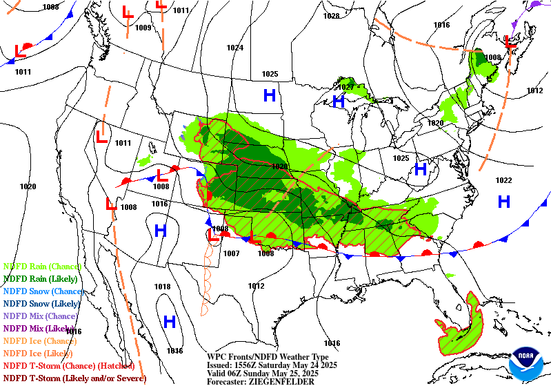
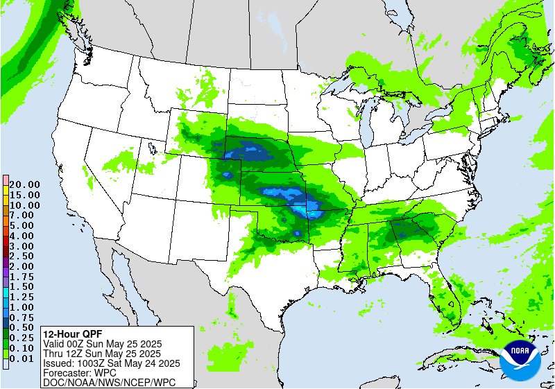
...Southeastern Kansas and Northeastern Oklahoma through the
Ozarks into the Tennessee Valley...
Recent mesoanalysis shows increasing PWs on the nose of strong low
level moisture advection across Oklahoma into southeastern Kansas.
Moisture is expected to continue to pool over this area and lift
northeast along a slow-moving low level boundary. Elevated
convection developing along the boundary has been training
northwest to southeast across southwestern Missouri into northern
Arkansas over the past several hours, resulting in localized 1-2
inch estimated totals. Hi-res guidance indicates these training
storms will continue through the remainder of the overnight and
beyond daybreak ahead of an upstream system now organizing over
Kansas. The general consensus of the hi-res guidance shows this
system continuing to grow upscale, with rainfall rates increasing
as it drops southeast into the axis of deeper moisture and greater
instability. Heavy rainfall will likely be ongoing within the
highlighted area as this system moves through the region near the
start of the period. Guidance differs on the details, but most
indicate a downward trend in rainfall rates as the system moves
progressively to the south and east and begins to weaken later this
morning.
Following this morning's round, attention will then focus to the
evening and overnight, when some of the hi-res guidance shows
storms redeveloping over the Plains and propagating east into some
of the same areas impacted by the morning convection. Models show
low level flow amplifying, supporting a deepening moisture pool in
much the same area, providing the opportunity for storms to once
again produce heavy rainfall rates, with additional heavy
accumulations possible. Currently, the greatest area of concern
centers over eastern Oklahoma into northwestern Arkansas. HREF
neighborhood probabilities for 24-hr accumulations exceeding 3
inches are above 50 percent across the region, with some greater
than 25 percent probabilities for accumulations over 5 inches
centered over the Boston Mountains.
...Southeastern Wyoming, Northeastern Colorado and the western
Nebraska Panhandle...
Moist easterly flow will support PWs ~0.75-1 inch (1.5-2 standard
deviations above normal), which along with mid-level energy and
right entrance region jet forcing, will support storm development
with locally heavy rainfall possible from the Laramie Mountains
and Frontal Range into the High Plains. A Marginal Risk was added,
highlighting the area where the HREF indicates that localized
amounts exceeding 2 inches are possible.
Pereira
Day 1 threat area:
www.wpc.ncep.noaa.gov/qpf/94epoints.txt
Excessive Rainfall Discussion
NWS Weather Prediction Center College Park MD
417 AM EDT Sat May 24 2025
Day 2
Valid 12Z Sun May 25 2025 - 12Z Mon May 26 2025
...THERE IS A MODERATE RISK OF EXCESSIVE RAINFALL FROM
FAR SOUTHEASTERN KANSAS AND NORTHEASTERN OKLAHOMA INTO THE
OZARKS...
...Southern and central Plains through the Ozarks into the
Tennessee Valley...
Storms developing Saturday night and early Sunday may remain
ongoing through the early part of the period across the Ozark
region. These storms are expected to move east and weaken early in
the period. However, there remains a strong signal for
redevelopment during the evening and overnight hours along a
lingering boundary extending from Oklahoma through the Ozarks.
Enhanced low level convergence will support pooling moisture,
fueling heavy rainfall rates with some potential for training as
this moisture interacts with a series of mid level shortwaves.
Meanwhile, strengthening southerly winds ahead of an amplified
trough moving across the Southwest will support deepening moisture
along the western extent of the front and an increasing threat for
heavy rainfall back across southwestern Oklahoma into northwestern
Texas. Some of this activity may also reach the Ozark region by the
end of the period. With these repeating events expected to push
rain totals into the 4-6 inch range in some spots, a Moderate Risk
centered over northeastern Oklahoma into the Ozarks was maintained.
While the better organized and heaviest amounts are expected to
center near the Ozarks, there is the potential for localized heavy
amounts, producing isolated flash flooding concerns, to spread
further east along the boundary through the Tennessee Valley and
into areas as far east as the southern Appalachians.
....Central Rockies/High Plains...
Moisture and forcing will remain favorable for additional rounds
of showers and thunderstorms, capable of producing heavy rainfall
rates. While widespread heavy totals are not expected, models do
show a notable signal for locally heavy amounts, which may raise
isolated flash flooding concerns over eastern Wyoming into western
South Dakota and the Nebraska Panhandle, as well as over portions
of northeastern Colorado.
Pereira
Day 2 threat area:
www.wpc.ncep.noaa.gov/qpf/98epoints.txt
Excessive Rainfall Discussion
NWS Weather Prediction Center College Park MD
417 AM EDT Sat May 24 2025
Day 3
Valid 12Z Mon May 26 2025 - 12Z Tue May 27 2025
...THERE IS A SLIGHT RISK OF EXCESSIVE RAINFALL ACROSS PARTS OF THE
SOUTHERN PLAINS TO THE TENNESSEE VALLEY...
While some additional heavy rains are possible across the Ozarks,
the greater threat is expected to shift further south as an upper
trough moves from the Southwest into the Plains. This will push the
front and deeper moisture further south and east. Deep, moist
southwesterly flow, with energy aloft, will support an axis for
storms to develop from eastern Texas and southeastern Oklahoma to
the Tennessee Valley. The overnight models showed enough spread to
encourage maintaining just a Slight Risk for now. However, some of
the guidance, including the GFS, UKMET, and CMCreg, are producing
amounts suggesting an upgrade may be required in a future issuance.
Pereira
Day 3 threat area:
www.wpc.ncep.noaa.gov/qpf/99epoints.txt
Extended Forecast Discussion
NWS Weather Prediction Center College Park MD
259 AM EDT Sat May 24 2025
Main developing lows along a wavy frontal system over the South
should are slated to progress northeastward Tuesday and Wednesday.
This will expand a threat of localized heavy rain up through the
south-central Appalachians region/Mid-Atlantic, while the moisture
pooling trailing front lingers back across the South to focus
locally heavy convective downpours chances that may extend well
into next week with advent and reinforcement from Midwest
cyclo/frontogenesis from northern stream energies. The WPC
Day4/Tuesday Excessive Rainfall Outlook (ERO) depicts an elongated
Marginal Risk threat area from Texas into the south-central
Appalachians region/Mid-Atlantic given deep moisture and upper
support. A Day 5/Wednesday WPC ERO Marginal Risk shows best focus
lingering over the southeast Mid-Atlantic with lead low passage and
also back over the southern Plains/Lower Mississippi Valley with
ejecting southern stream impulse induced return flow.
In the West, a building upper ridge will lead to an expanding area
of heat from the Intermountain West into the West Coast states,
with temperatures rising upwards to 10 to 15+ degrees above normal
during the second half of next week that in particular may lead to
a hazardous heat focus over the California Central Valley heading
into and through next weekend.
Schichtel


