Extended Forecast Discussion...UPDATED
NWS Weather Prediction Center College Park MD
326 PM EDT Thu May 22 2025
Valid 12Z Sun May 25 2025 - 12Z Thu May 29 2025
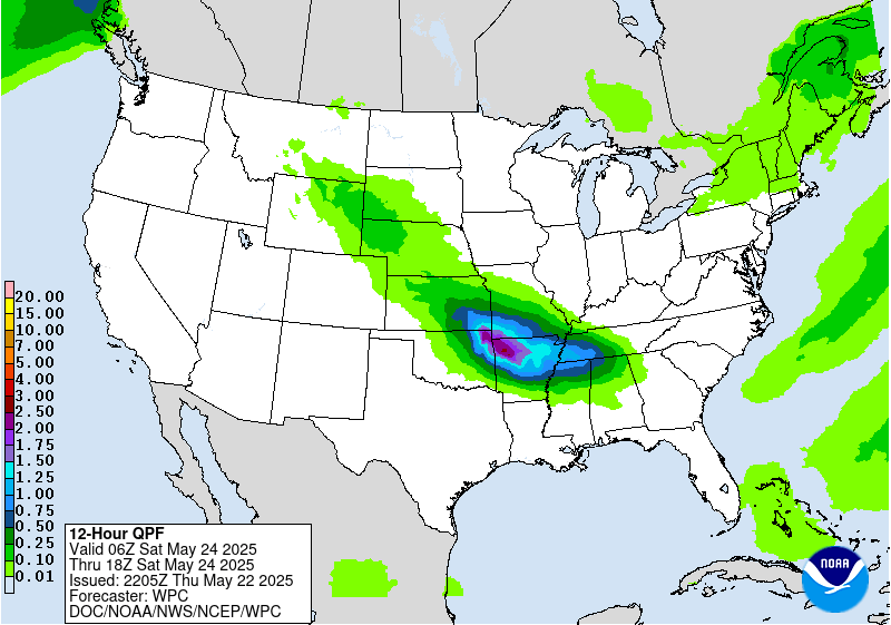
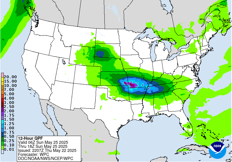
...Heavy rain and flash flooding concerns continue in the Ozarks
and vicinity Sunday...
...Overview...
A pattern supporting heavy rain and thunderstorms will be in place
as the period begins Sunday, as an upper trough atop the Rockies
Sunday moves east with ample moisture and instability streaming
into a frontal system in the central U.S. ahead of it. Flash
flooding is expected in the Ozarks and vicinity as part of a
potentially significant multi-day heavy rainfall event. This trough
tracking east will combine with another trough stretching from the
East westward across the Great Lakes, causing the trough to dig
atop the east- central U.S. and finally press the front and the
resultant rainfall southeast across the southern tier into the
Appalachians and eventually the Eastern Seaboard. The rounds of
troughing aloft will cause cooler than normal temperatures in parts
of the central and eastern U.S., while upper ridging building in
the Intermountain West should allow for warmer than average
temperatures there.
...Guidance/Predictability Assessment...
The latest model guidance shows an initially blocky pattern
heading into the weekend with a lingering upper-low over the
northeastern U.S./Great Lakes, strong ridge anchored north into
south-central Canada, and another upper-low over the northeastern
Pacific. A lingering quasi-stationary frontal boundary from the
passage of this northeastern U.S. upper-low will be draped across
the Southeast west through the Mississippi Valley into the Southern
Plains, providing the focus for multiple days of widespread
shower/storm development. All of the guidance is in generally good
agreement depicting a somewhat complex evolution of southern stream
shortwave energy that will breakthrough under the prevailing
upper-ridge and slowly progress eastward from the western U.S. and
over the Plains Sunday into Monday, potentially combining with
additional lingering upper-energy from the upper-low over the
northeastern U.S. This should eventually lead to lee cyclogenesis
over the Plains and help to usher the frontal system eastward
through early to mid-next week. There is some discrepancy with the
exact evolution of this system as it lifts northeastward through
the Mississippi and into the Ohio Valley before approaching the
East Coast with regard to secondary coastal low development, though
the guidance tends to favor this development at some point mid-
next week which will have impacts on rainfall potential/amounts
extending into the Mid-Atlantic/Northeast.
There is greater disagreement in the pattern to the west early to
mid-next week as shortwave energy ejects from the northeastern
Pacific low. The 00Z ECMWF/CMC/UKMET (as well as the ensemble
means) generally agree that this wave will make slow progress as
the upper-ridge over south-central Canada and into the Interior
West remains entrenched to its east before eventually, potentially
weakening and lifting northeastward. The frontal system reflection
at the surface is expected to eventually dissipate given the
ridging to the east, with modest sensible weather impacts expected.
The lingering upper-energy may also eventually merge with
additional southern stream energy approaching from the Pacific. On
the other hand, the 00Z GFS was weaker with this upper
-ridge, and the 06Z had a much different solution depicting the
upper-wave helping to breakdown the ridging by merging with upper
energy from the lingering upper-troughing across the Great
Lakes/Northeast, and eventually moving eastward over the
northern/central Plains. This would lead to much more
precipitation across the north-central U.S. to Great Lakes. The
latest 12Z update for the GFS also shows upper-troughing lingering
longer westward over the north-central U.S., potentially
reinforced by additional energy from the west, that would lead to
more additional heavy precipitation chances over the
Plains/Mississippi Valley.
The updated WPC forecast blend includes a composite of the
available 00Z guidance (favoring the 00Z GFS given the noted
differences in the 06Z) given generally similar solutions. A
contribution from the means is included with a reduced contribution
from the 00Z GFS/CMC later in the period given naturally growing
differences, with larger differences specifically with the 00Z GFS.
This blend provides for good continuity with the prior WPC
forecast.
...Weather/Hazards Highlights...
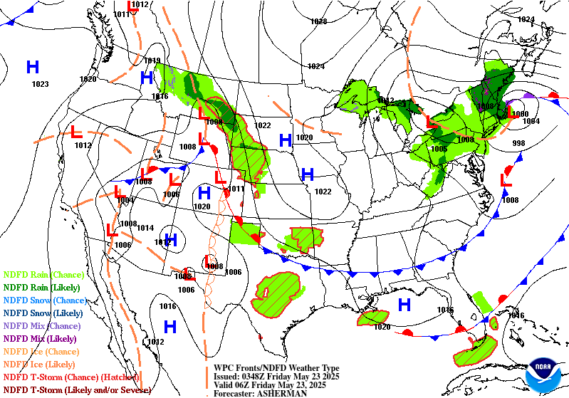
A wavy west-east oriented front will be in place over the south-
central Plains and Mississippi Valley on Sunday. Moisture
(precipitable water) values likely over the 90th percentile and
ample instability will stream into the front, and the right
entrance region of the jet provides dynamical support. This will
lead to additional heavy rain, perhaps in multiple rounds, likely
centered in the Ozarks and vicinity on Sunday. This follows heavy
rainfall expected over almost the exact same region the prior two
days. A targeted Moderate Risk ERO has been introduced to cover the
third day of a potentially significant multi-day heavy rain and
flash flooding event given increasingly wet antecedent conditions.
A broader Slight Risk is in place from the south-central Plains
into parts of the Lower and Middle Mississippi Valley. Due to
models converging better on timing and placement of convection, the
size of a broader Marginal Risk has been reduced compared to the
previous couple of issuances.
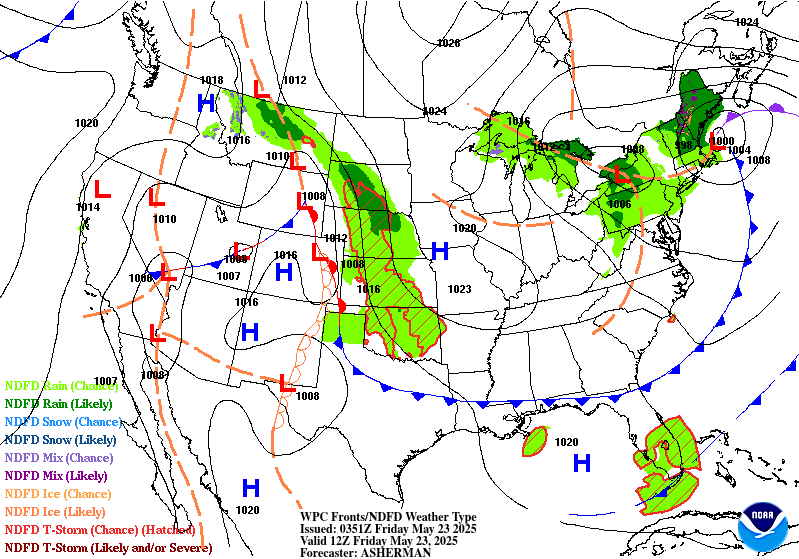
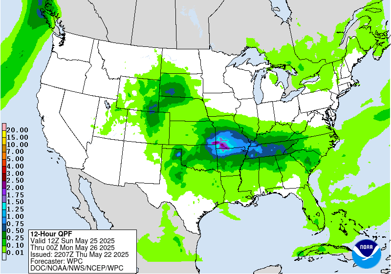
By Memorial Day, the trough aloft should finally press the front
gradually south toward the southern tier and east toward the
Appalachians. Moisture and instability in place could still lead to
heavy rain rates across the south-central U.S. into the Tennessee
Valley and Lower Ohio Valley, but at least there should be
relatively less potential for training storms as the front moves.
For the Day 5/Monday ERO, show a Marginal Risk delineated across
these areas as a starting point. Embedded Slights may be needed in
future issuances but the details still need to be refined with
time, and much of this region will have been dry in the prior days
leading to high FFG values. On Tuesday, the eventual dominant low
on the frontal system should lift northeast and bring localized
heavy rain to the Eastern Seaboard, especially the Mid- Atlantic,
while the trailing front still lingers and causes showers and
storms across the southern tier Tuesday- Wednesday.
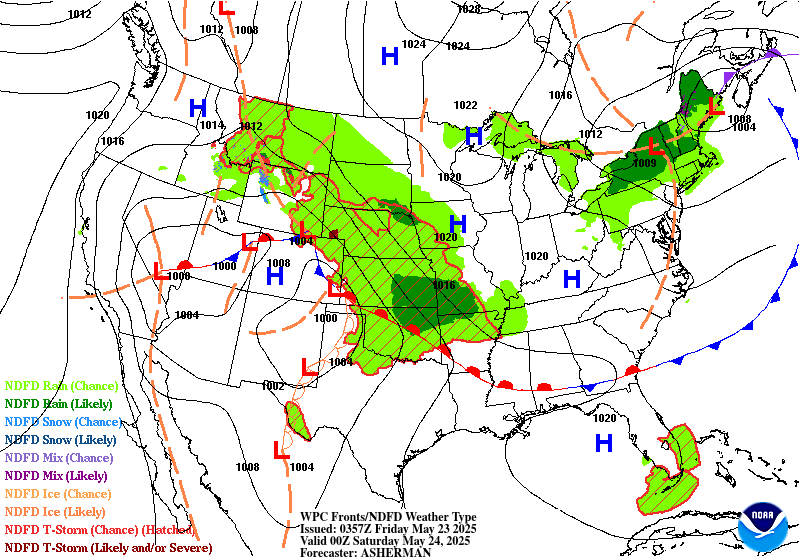
Farther north, the initial trough should produce some modest
precipitation in the central Rockies (even some snow in the highest
peaks) and the northern/central Plains early next week. The
frontal boundary curling back into the southern/central Rockies and
High Plains could help produce scattered convection there next
week as well. Meanwhile, rounds of fronts coming through the
Northwest could allow for light to moderate precipitation.
Summertime scattered storms are also likely across the Florida
Peninsula.
One more day of hot weather is likely for Texas across the
Southeast on Sunday. Temperatures well into the 90s to around 100
will support areas of Major HeatRisk in southern parts of Texas and
Louisiana. Meanwhile, cooler than normal temperatures by 5 to 15
degrees will take hold over the north-central to eastern U.S. into
early next week underneath upper troughing. The trough and front
pressing south will allow for temperatures to cool in the southern
tier Monday and Tuesday. The cooler temperatures should gradually
moderate closer to normal as next week progresses. But in the West,
a building upper ridge will lead to warmer than average
temperatures by 10 to 15 degrees for several days over the Great
Basin and northern/central Rockies.
Putnam/Tate
Additional 3-7 Day Hazard information can be found on the WPC
medium range hazards outlook chart at:
https://www.wpc.ncep.noaa.gov/threats/threats.php
WPC medium range 500mb heights, surface systems, weather grids,
quantitative precipitation forecast (QPF), excessive rainfall
outlook (ERO), winter weather outlook (WWO) probabilities, heat
indices, and Key Messages can be accessed from:
https://www.wpc.ncep.noaa.gov/medr/5dayfcst500_wbg.gif
https://www.wpc.ncep.noaa.gov/medr/5dayfcst_wbg_conus.gif
https://www.wpc.ncep.noaa.gov/5km_grids/5km_gridsbody.html
https://www.wpc.ncep.noaa.gov/qpf/day4-7.shtml
https://www.wpc.ncep.noaa.gov/#page=ero
https://www.wpc.ncep.noaa.gov/wwd/pwpf_d47/pwpf_medr.php?day=4
https://www.wpc.ncep.noaa.gov/heat_index.shtml
https://www.wpc.ncep.noaa.gov/#page=ovw


