Excessive Rainfall Discussion
NWS Weather Prediction Center College Park MD
1157 AM EDT Tue May 27 2025
Day 1
Valid 16Z Tue May 27 2025 - 12Z Wed May 28 2025
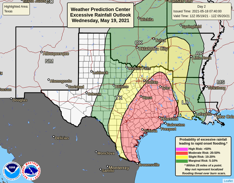
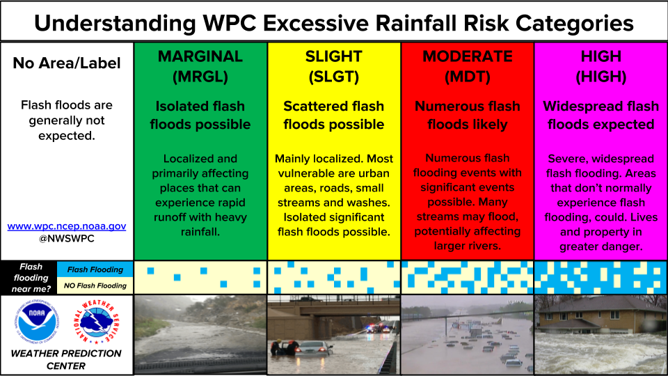
...THERE IS A SLIGHT RISK OF EXCESSIVE RAINFALL ACROSS PORTIONS OF
THE OHIO VALLEY, SOUTHEAST U.S., AND TEXAS...
...16Z Update...
No wholesale changes were needed to the previous ERO issuance. Was
able to connect the Slight Risks through the Tennessee Valley
where recent CAMs have shown (low) probabilities for exceeding FFG
and heavy QPF in what was the gap between them. In areas like
eastern Louisiana/western Mississippi where initial convection has
cleared, trimmed the Slight Risk out of those areas. CAMs show some
showers possibly popping up again this afternoon/evening in the
Lower Mississippi Valley, but with the atmospheric turnover leading
to less instability, expect those showers to stay light enough the
Marginal will cover it. Regarding the Carolinas, recent models
have shown convection focusing offshore of Wilmington NC and
vicinity rather than onshore, so the Slight Risk was removed into
NC and eastern SC. See the previous discussion below for further
information on the south-central to southeastern U.S./Ohio Valley
threat areas.
...North-Central High Plains...
A shortwave diving southeastward in the north-central Plains
rounding the north-central U.S. upper low will provide support
aloft for convection, while a tongue of higher theta-e streams into
the High Plains. CAMs show instability (surface based CAPE) of
around 1000 J/kg but with ensemble max CAPE possibly exceeding
2000. A trough or weak front at the surface with the theta-e
gradient just to the east could enhance surface convergence to
force convection. In this issuance, extended the Marginal north
into Wyoming given the same type of environment there as farther
south, plus the HREF probabilities were 30 to 70 percent for
exceeding 2 year ARIs in portions of Wyoming.
Tate
...Previous Discussion...
...Ohio Valley...
A multi-round rain threat with stronger convective roots in the
afternoon and evening will occur across portions of the Ohio
Valley. Initial impacts will lean more on the tamer side with the
approach of a mid-level vorticity maxima currently moving
northeast out of TN. Approach of the shortwave energy between
12-18z will allow for accompanying light to moderate rainfall
providing some initial priming of the soils in areas like Eastern
KY up through the western half of WV. Initial progs indicate little
to no instability with the initial batch, so the threat for flash
flooding is minimal in the first portion of the forecast. Later in
the afternoon, a strengthening speed max will nose into the Central
Ohio Valley with increasing RER dynamics to couple with a tongue
of relatively modest instability running west of the Appalachian
front. 00z CAMs are on-board with a period of convection firing
within the confines of the Cumberland Gap up through Eastern KY and
Southern WV, enough of a signal to warrant flash flood prospects
within an area that is more prone to flash flood risks given the
complex topography. The area of greatest focus will likely be the
area across North-Central TN up through Eastern KY where the core
of the greatest theta_E advection will occur and steeper lapse rate
presence as you position south of RLX territory.
00z HREF neighborhood probs for >1" are over 90% for all of
Southwest WV down through Eastern KY with 70+% over much of Eastern
TN. >2" probs do fall over WV with more of a signal positioned
across Eastern KY and TN, a testament to the expected range of
precip for the convective period. It's unlikely to see widespread
significant flooding in this scenario, but these setups within a
formidable deep moisture presence (low to mid-level RH >80% and
PWATs ~ +2 deviations) typically can surprise within a good
dynamical pattern. The previous SLGT risk was maintained with some
trimming around the western and northern edges of the risk area.
It's possible the risk gets scaled back across WV if trends allow
for it, but wanted to maintain some continuity overall with the
threat still lingering across Southwestern WV when assessing the
accompanying dynamics. The SLGT risk is very much in play for
locations further south in Eastern KY and the Cumberland Gap of
TN.
...Southeast U.S...
Shortwave energy currently analyzed over TX will move eastward into
the Lower Mississippi Valley and continue to plug eastward through
the course of Tuesday allowing for scattered to widespread
convective activity during its progression. Quite a large MCS is
maneuvering through Central TX with cold pool mergers helping to
feed the complex and maintain its forward momentum beyond the I-35
corridor. Energy analyzed over TX is helping fuel the disturbance
with a strong likelihood of the energy associated migrating
eastward over the next 24 hrs with regional ascent maximized within
proxy of the shortwave. Deep moisture pooling with Gulf roots will
lead to widespread 1.8-2.1" PWATs across all of the Southeast with
a core of elevated theta_E presence aligned west to to east from
LA over into GA during the daytime hours Tuesday. Despite a
relatively progressive forward motion of convection, heavier
convective cores will materialize across the South with rates
between 2-3"/hr possible, including some heavier intra-hour rates
that could drive localized flooding concerns higher, an issue that
is profound in these types of environments. 00z HREF EAS depiction
for >1" is over 70% for large chunk of the Southeastern U.S. with
modest probs (20-35%) for at least 2" in the same corridor of
Central LA through West-Central GA. Neighborhood probabilities back
up the threat with >3" signaling 50-80% over much of the area
stretching from Baton Rouge to just west of Atlanta. Considering
1/3/6 hr. FFG's being slashed considerably over the past 24 hrs.
due to waves of convection over MS/AL, the prospects for flash
flooding are heightened a bit more than usual. The areas of
greatest concern will be those that saw significant rainfall this
previous period and those urban centers that exhibit greater runoff
potential normally. The previous SLGT risk was generally
maintained with only some minor adjustments based off the expected
blended mean QPF from the hi-res ensemble suite.
Across Southeast NC, surface low development off SC coast will
spur some significant rainfall over the coastal plain between OBX
down to northeastern fringe of SC. Recent hi-res trends have seen a
pretty substantial uptick in-of that corridor with some CAMs
members boosting QPF over 6" during a 6-12 hr. span Tuesday night
into Wednesday morning. Strong low-level convergence and prevailing
flow directly off the Atlantic will be the culprit for enhanced
rainfall potential in proxy to the coast. It's a tight window to
contend with leading to some uncertainty on totals, but the threat
is within reason synoptically, so long as guidance has a handle on
cyclogenesis. The previous SLGT risk was maintained given the
recent short range trends.
...Texas...
A series of strong mid-level perturbations will eject out of
Coahuila and Chihuahua thanks to the affects of a migrating
shortwave trough currently situated over Sonora. A significant
uptick in convective development across the Serranias del Burro and
Chihuahua will ultimately lead to heavy thunderstorms plowing east
out of Mexico, eventually impacting the Lower Trans Pecos,
Stockton Plateau, and eventually the Edwards Plateau down through
the Rio Grande after 00z. Environmentally speaking, there will be
a abundance of instability available during peak convective impact
with a strong buoyant signature situated from the Stockton Plateau
to points southeast with a large span of 2000-4000 J/kg of MUCAPE
in that expected zone. PWATs will be ~1 deviation above normal, a
relatively favorable moisture regime that can yield some elevated
precip potential, albeit sort of capped in higher potential. The
main concern with the setup will occur overnight where cold pool
mergers can lead to cells maturing and collapsing over the same
area for several hours leading to prolonged heavy rainfall. The
initial surge of the convective impacts will be most notable in the
towns along the Rio Grande up to the Stockton Plateau. Areas
downstream over the hillier terrain will be most susceptible to the
eventual cold pool merger/decay pattern with 2-5" of rainfall
plausible in either of these impact scenarios. Blended mean QPF
from the latest HREF output is signaling a 2-4" bullseye within
proxy of the Rio Grande, putting places from Del Rio down towards
Laredo at the brunt of the convective surge. Neighborhood
probabilities for >3" of rainfall in 6-hrs (40-60%) are relatively
high, but the key is the anticipated hourly rates to be generally
1-2"/hr with higher intra-hour potential given the steep lapse
rates and formidable mid-level ascent over the region. This likely
spur scattered flash flood instances over areas impacted with a
higher threat further north into the Edwards Plateau due to recent
priming from previous heavy rainfall. The SLGT risk inherited was
maintained with some extension back into the Stockton Plateau given
the correlation of convection development off the Davis and
Glass Mountains that could lead to flooding concerns along I-10 in
Pecos County Texas. The SLGT risk was also expanded north into the
Concho Valley as convection over the same areas hit hard recently
will offer a greater potential for flash flood prospects as FFG's
have taken quite a hit the past 24 hrs.
Kleebauer
Day 1 threat area:
www.wpc.ncep.noaa.gov/qpf/94epoints.txt
Excessive Rainfall Discussion
NWS Weather Prediction Center College Park MD
1157 AM EDT Tue May 27 2025
Day 2
Valid 12Z Wed May 28 2025 - 12Z Thu May 29 2025
...THERE IS A MARGINAL RISK OF EXCESSIVE RAINFALL ACROSS MUCH OF
THE SOUTHERN AND CENTRAL HIGH PLAINS, TEXAS, LOWER MISSISSIPPI
VALLEY, AND CENTRAL GULF COAST ...
...Central High Plains...
Longwave pattern across the CONUS will become "blocky" with a large
closed ULL centered over the Midwest with vorticity maxima pivoting
around the general circulation. A shortwave currently analyzed over
the High Plains of Canada will get caught in the western periphery
of the ULL and rotate quickly to the south and southeast by the
middle and latter stages of D2 leading to convective enhancement
with a likely MCS definition as we move into the end of the period.
There's a growing consensus on the evolution beginning upstream
over the Front Range, eventually crossing through the Central High
Plains of KS with upscale growth of any convective segment sliding
down prevailing northwesterly steering flow. As the complex loses
latitude and reaches the southern periphery of the sprawling ULL,
the disturbance will slow and eventually pivot eastward allowing a
training axis to occur somewhere over Southern KS. Ensemble bias
corrected QPF is fairly aggressive in the signature with max QPF
orientation aligned from DDC down towards North-Central OK. This
has been pretty well-documented so far with relatively consistency
in guidance, so the threat is certainly increasing for a regional
bout of heavy rainfall. The area expected to see the most rain is
actually one of the "drier" areas of KS leading to modest FFG
indices in the 1/3/6-hr temporal scales. Areal average of 2-3" with
max potential of up to 4" is forecast across the axis referenced
above. 1-2" will surround the forecast maxima leading to some
isolated flash flood concerns in those areas if the orientation of
the complex shifts. Overall, a MRGL risk is in place for the
threat with a potential for a targeted upgrade if the current
assessment proves to be favored leading in.
...New Mexico and Texas...
Persistence in a narrow theta_E ridge from West TX up through the
Southern Rockies will lead to another shot at scattered
thunderstorms over the terrain with locally heavy rainfall causing
some flash flood concerns in complex topography. Remnant burn scars
up over Northern NM have been hit the past few days with high
runoff capabilities leading to flash flooding in those targeted
zones. This threat will remain for D2 with some isolated heavy
cores also possible as far south as the Sacramento Foothills.
West Texas will see an initiation of thunderstorms across the Big
Bend up to the Stockton Plateau and adjacent terrain of Southwest
TX. Threat is very localized, but considering the environment in
place, any cells will have the opportunity for a quick 1-2" of
rainfall that would ultimately cause issues over the area. A
relative min in QPF is anticipated over the Permian Basin and
Caprock area of Eastern NM and High TX Plains. This is well
documented within the QPF distribution allowing for a "donut hole"
for a nil ERO to be positioned in the area of the QPF minimum.
Across Central and East TX, thunderstorm complex will materialize
the back end of D1 and roll into D2 with heavy rainfall forecast
across the Piney Woods and Upper coastal areas of TX. This will be
back to back days this is forecast or will have occurred leading to
some threat of localized flooding pending soil saturation and
recovery response in the area. Totals between 2-3" will be possible
across portions of the TX coast up into the Lower Sabine, so
realistically, localized flooding will remain a threat for at least
another period. Any convective development across Central TX
Wednesday will lead to another isolated flash flood threat after
this evenings rainfall and any Tuesday additions will lead to
solidly primed soils within a region that is prone to flash flood
concerns due to higher runoff capabilities.
For each of the areas mentioned in the above sections, a MRGL risk
is forecast with the best opportunity for upgrades potentially
across the Upper TX coastal area into the Piney Woods.
...Lower Mississippi Valley and Gulf Coast...
Complex developing upstream over TX will eventually work its way
into the Lower Mississippi Valley with more heavy rainfall concerns
in-of the energy associated with the progressing complex. This area
has relatively high FFG's leading in, so the threat will remain
fairly isolated overall with max QPF outputs generally within the
2-4" range with the heaviest more likely to be closer to the Lower
Sabine than areas further east. Still, there's reasonable consensus
on a stripe of elevated QPF from the expected convective impacts
moving overhead leading to a lower-end MRGL risk for the Lower
Mississippi area, mainly LA. Across the Central Gulf Coast, heavier
cells within a moisture rich environment could spawn over areas a
little more sensitive (urban areas) between New Orleans to
Tallahassee. The risk is low-end, but some guidance has been trying
to put heavier QPF signatures within proxy of those areas. Steering
flow will be relatively weak so a shot for cells to retain some
longevity over the same areas. A MRGL risk remains in place over
each area.
Kleebauer
Day 2 threat area:
www.wpc.ncep.noaa.gov/qpf/98epoints.txt
Excessive Rainfall Discussion
NWS Weather Prediction Center College Park MD
1157 AM EDT Tue May 27 2025
Day 3
Valid 12Z Thu May 29 2025 - 12Z Fri May 30 2025
...THERE IS A SLIGHT RISK OF EXCESSIVE RAINFALL ACROSS PORTIONS OF
THE SOUTHEAST...
A tricky setup is on tap for much of the CONUS situated east of the
Rockies with a broad ULL helping dictate the pattern encompassing
two-thirds of the nation. Across the Southeast, a corridor of
elevated PWATs and associated instability will be present south of
the primary low. A cold front will begin a southward advancement
with cooler, stable air making headway through the Ohio Valley the
beginning of the period. As the front sags south a broad axis of
pre-frontal convergence will transpire with scattered to widespread
thunderstorms likely situated across much of the South. The issue
becomes a discrepancy in timing of the front, precip location, and
any boundaries that could enhance convective posture. What is known
is the environment favors heavy rainfall for anything that does
develop and that trend will remain steady all the way through the
eventual setup. Ensemble depictions are more stable in the QPF
distribution compared to the deterministic where several
iterations of output are available with maxima situated anywhere
from Tennessee down to the Gulf Coast to as far west as TX.
Ensemble means are positioned over an axis from Jackson, MS towards
Western GA, a corridor that will be well-saturated by the D3 time
frame leading to a greater threat for flooding in those areas. With
a pretty high chance of somewhere in the South getting anywhere
from 2-4+" of rainfall, the forecast SLGT risk in place outlines
the region that would have the greatest threat considering the
ensemble QPF and relevant FFG's expected by D3. The risk area
could very well adjust, but went with the area of greatest
interest, correlating well with the current ensemble output of
heavier QPF.
More scattered to widely scattered thunderstorms will develop
across much of Texas leading to localized flash flood concerns for
yet another day with the best threat occurring Thursday afternoon
and evening. The threat will be most suitable within areas of
higher saturation from previous periods of rainfall, urban areas,
and complex topography.
Kleebauer
Day 3 threat area:
www.wpc.ncep.noaa.gov/qpf/99epoints.txt
