Excessive Rainfall Discussion
NWS Weather Prediction Center College Park MD
852 PM EDT Sat May 24 2025
Day 1
Valid 01Z Sun May 25 2025 - 12Z Sun May 25 2025
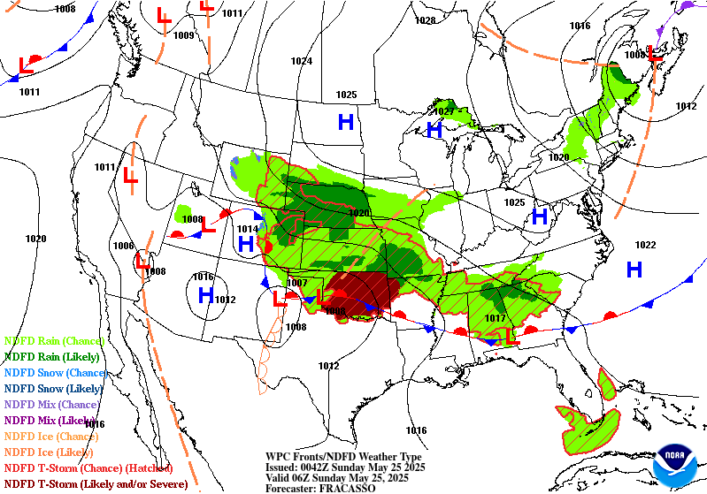
...THERE IS A SLIGHT RISK OF EXCESSIVE RAINFALL FOR THE OZARKS AND
MID-SOUTH...
01Z Excessive Rainfall Discussion...
No fundamental shift in forecast reasoning from previous outlook.
Did expand the Marginal and Slight risk areas a bit westward given
the uncertainty about where the storms will fire that build
southeast into the outlook areas. The expectation is that the
convection will grow in areal coverage and intensity once the low
level jet develops and rides north of a quasi-stationary boundary
draped across the Plains later tonight. Also extended the Marginal
risk area southwest into Texas along and ahead of storms that were
developing along/near the dryline within a very unstable
environment. Given a slow westward motion noted on
satellite...any downpours may last long enough to produce isolated
instances of flooding (mainly in regions of poor drainage).
Bann
...Previous Excessive Rainfall Discussion...
...South-Central Plains through Mid-South into the Southeast...
16Z Update...
Organized mesoscale systems continuing this morning over eastern
OK, central AR and some activity over northern MS/AL. This activity
is waning with IR satellite imagery depicting warming trends.
There is general agreement among 12Z CAMs for afternoon
redevelopment over southeast KS/northeast OK over the Plains and
propagating southeast over eastern OK, southeast MO and much of AR
which all saw heavy rain over the past day (except for northwest AR
which was largely avoided). These storms should once again produce
heavy rainfall rates, per 12Z HREF with probabilities for 3 inches
in three hours and RAP guidance renewing 1.75 inch PW on the
continued southerly flow from the Gulf. Extra caution should be
given through the greater Ozarks region given this holiday weekend
with greater activity in and around flash flood prone areas.
Frontal convergence farther east through northern GA will allow
scattered heavy development where the Marginal Risk was expanded
through.
...Central High Plains...
Moist low level easterly flow maintains PWs of 0.75 to 1 inch (2+
standard deviations above normal), which along with mid-level
energy and right entrance region jet forcing, will continue to
support storm development with locally heavy rainfall over the High
Plains with afternoon development east from the Laramie Mountains
and Front Range. Slow storm motions could allow local rainfall of
2 to 3 inches. The Marginal Risk was expanded over western Neb and
southeast WY with some shrinking along the I-25 corridor in CO.
Jackson
Day 1 threat area:
www.wpc.ncep.noaa.gov/qpf/94epoints.txt
Excessive Rainfall Discussion
NWS Weather Prediction Center College Park MD
852 PM EDT Sat May 24 2025
Day 2
Valid 12Z Sun May 25 2025 - 12Z Mon May 26 2025
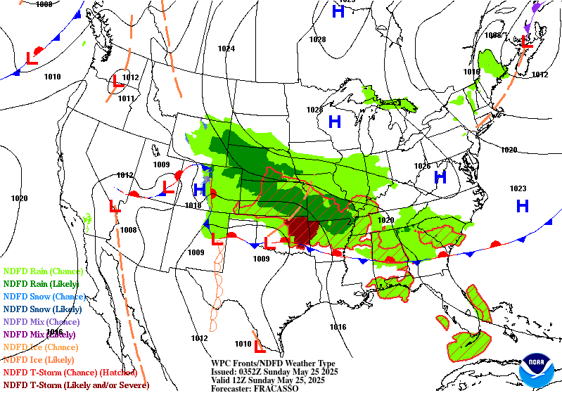
...THERE IS A MODERATE RISK OF EXCESSIVE RAINFALL FROM
CENTRAL OKLAHOMA INTO THE OZARKS...
...Southern Plains through the Ozarks and Mid-South...
21Z Update...
Expanded the Moderate Risk south and west to include central
Oklahoma and more of northwest Arkansas.
Convective activity tonight looks to focus along a broad swath over
southern KS, eastern OK and southern MO and shift southeast early
Sunday over eastern/central OK and northern AR where a stationary
front is likely to remain. Strengthening southerly winds ahead of
an amplified trough moving across the Southwest will support
deepening moisture along the front and an increasing threat for
heavy rainfall back across southwestern Oklahoma and along the Red
River Valley. With these repeating events expected to bring
additional rain of 2 to 4 inches with locally higher, the Slight
Risk was expanded to include much of OK as well as more of AR.
While the better organized and heaviest amounts are expected to
center over Oklahoma through the Ozarks, there is the potential
for localized heavy amounts and isolated flash flooding to spread
east along the frontal boundary through the Tennessee Valley,
north Georgia (including Atlanta) and much of South Carolina where
a Marginal Risk has been expanded through.
....Front Range/Central High Plains...
Moisture and forcing will remain favorable for a diurnal focus to
locally heavy rain starting on the Front Range Sunday afternoon and
spreading west in the mean flow across the central High Plains. A
Marginal Risk remains in effect for northeastern Colorado, the
Nebraska Panhandle, far southeast Wyoming into southwest South
Dakota.
Jackson
Day 2 threat area:
www.wpc.ncep.noaa.gov/qpf/98epoints.txt
Excessive Rainfall Discussion
NWS Weather Prediction Center College Park MD
852 PM EDT Sat May 24 2025
Day 3
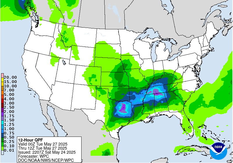
Valid 12Z Mon May 26 2025 - 12Z Tue May 27 2025
...THERE IS A SLIGHT RISK OF EXCESSIVE RAINFALL FROM THE SOUTHERN
PLAINS TO THE TENNESSEE VALLEY...
21Z Update...
While some additional heavy rains are possible in eastern Oklahoma
and across the Ozarks, the greater threat is expected to be farther
south than recent days as an upper trough axis ejects from the
Southwest over the southern Rockies and onto the southern Plains
Monday. This will push the front and deeper moisture farther south.
Adjustments with the 12Z suite of guidance today is that the moist
southwesterly flow with energy aloft will support an axis for
storms over central/North Texas (farther west than prior runs)
through the Tennessee Valley. The Slight Risk was maintained with
expansion to the west over Texas. A targeted upgrade is likely
should these trends continue, though much of North and eastern
Texas have been fairly rain free over the past week with flash
flood guidance near their normal high values.
The motion of the upper trough axis over the Plains Monday night
should allow nocturnal activity over the central Plains. An arm to
the Marginal Risk was extended up through the KC metro into
southeast Nebraska for now, with a note that details on Plains
heavy rain threat areas should come into better focus over the
coming days.
Jackson
Day 3 threat area:
www.wpc.ncep.noaa.gov/qpf/99epoints.txt
Extended Forecast Discussion
NWS Weather Prediction Center College Park MD
239 PM EDT Sat May 24 2025
Main developing lows along a wavy frontal system over the South
are slated to progress northeastward Tuesday and Wednesday. This
will expand a threat of localized heavy rain up through the south-
central Appalachians region and Mid-Atlantic, while moisture pools
along a trailing front back across the South. This will focus
locally heavy convective downpours chances that may extend well
into next week with advent and reinforcement from Midwest
cyclo/frontogenesis from northern stream energies. The WPC
Day4/Tuesday Excessive Rainfall Outlook (ERO) depicts an elongated
Marginal Risk threat area from Texas into the south-central
Appalachians region/Mid- Atlantic given deep moisture and upper
support. A Day 5/Wednesday WPC ERO Marginal Risk shows best focus
lingering over the southeast Mid- Atlantic with lead low passage
and also back over the southern Plains/Lower Mississippi Valley
with ejecting southern stream impulse induced return flow.
In the West, a building upper ridge will lead to an expanding area
of heat from the Intermountain West into the West Coast states,
with temperatures rising upwards to 10 to 15+ degrees above normal
during the second half of next week that in particular may lead to
a hazardous heat focus over the California Central Valley heading
into and through next weekend.
Santorelli/Schichtel


