Excessive Rainfall Discussion
NWS Weather Prediction Center College Park MD
846 PM EDT Sat Jun 7 2025
Day 1
Valid 01Z Sun Jun 08 2025 - 12Z Sun Jun 08 2025
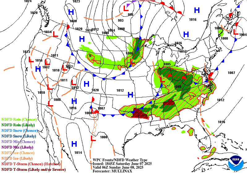
...THERE IS A SLIGHT RISK OF EXCESSIVE RAINFALL IN THE OHIO RIVER
VALLEY AND MID-SOUTH INTO THE SOUTHEAST...
01Z Update...
...Midwest and Central Appalachians...
Thunderstorms will continue develop in advance of an eastward
moving wave currently along the MO/IL border. This activity should
mainly form along the warm front currently extending from StL
through southern IN and organize a bit in the warm air advection
regime. PW increases behind the front to around 1.75", above the
90th percentile for early June, along with tall, skinny CAPE
profiles per model soundings that will make for efficient, low-
topped convection and scattered flash flood events. Of particular
concern will be the potential for flash flooding overnight from
central IN along the mid-upper OH Valley through WV. Southwest
low- level inflow increases over the terrain in the very moist
environment with the right entrance region of an upper level jet
streak providing divergence aloft. Locally significant flash
flooding will be possible given the terrain and relatively wet
antecedent conditions of the Slight Risk area.
...Mid-South through Southeast...
Forward propagating MCS pushes east over SC this evening with fast
motion. The leading cells that developed ahead of the line when it
was over GA are not occurring as much over SC, so the associated
flash flood threat is low overnight.
The next line of activity has developed across south-central AR and
is moving close to its orientation axis, causing repeating cells.
This will continue until enough cold pool can develop to begin a
propagation southeast into LA and over north-central MS/AL which
continues rest of the overnight. Despite dry antecedent conditions
and high FFG, the Slight Risk is maintained for potential for 2-4"
rainfall with high hourly rates and potential scattered instances
of flash flooding.
...Southern Plains...
Third consecutive night of supercells from the south-central High
Plains developing and shifting southeast. Expanded a Marginal Risk
from North Texas to these cells based on current motion and CAM
guidance like recent runs of the RRFS which maintain this activity
through tonight. This swath is mainly between the heaviest rain
from last night, but there is an isolated flash flood threat as
this activity propagates southeast.
...Northeast...
Low pressure has shifted well east of New England bringing rainfall
with it. Some heavy rain remains along the front over Long Island,
though the rates are not excessive. The EROs in the Northeast have
been removed.
Lamers/Jackson
Day 1 threat area:
www.wpc.ncep.noaa.gov/qpf/94epoints.txt
Excessive Rainfall Discussion
NWS Weather Prediction Center College Park MD
846 PM EDT Sat Jun 7 2025
Day 2
Valid 12Z Sun Jun 08 2025 - 12Z Mon Jun 09 2025
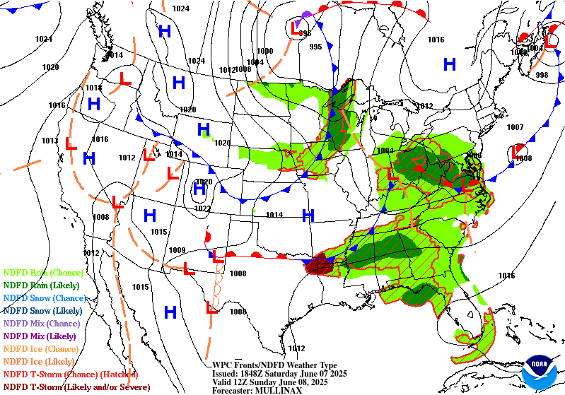
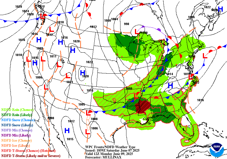
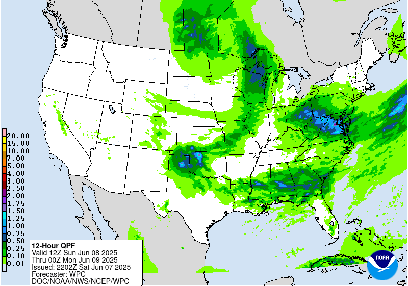
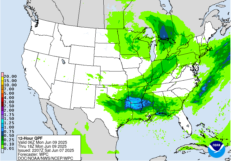
...THERE IS A SLIGHT RISK OF EXCESSIVE RAINFALL IN THE CENTRAL
APPALACHIANS AND MID ATLANTIC... AS WELL AS THE SOUTHERN PLAINS...
...Central Appalachians into the Mid-Atlantic...
The heavy rain and associated flash flood threat is likely to be
ongoing across portions of the region at the beginning of the
outlook period (12 UTC Sunday). Model guidance today has generally
begun to focus the QPF signal across the region such that there is
much better consistency between the global ensembles and hi-res
ensembles (both RRFS experimental ensemble and HREF operational).
Therefore, confidence was sufficiently high to go with a relatively
big departure from the existing more focused Marginal Risk area,
and go with a broad Slight Risk. The biggest change was to areas of
eastern Virginia and central Maryland, which previously had ERO
probabilities of less than 5 percent, but hi-res guidance is now
consistently showing some localized maxima in excess of 3 inches
into the coastal plain.
Greatest concern within the Slight Risk area is in the Allegheny
Mountains, Potomac Highlands and Laurel Highlands of northeast
West Virginia, the Maryland Panhandle, far southwest Pennsylvania,
as well as the Shenandoah Valley and Blue Ridge Mountain region of
far northwest Virginia. These areas have been very wet lately, with
30-day rainfall double to triple the normal amount, and a
significant portion of the same area received between 1 and 4
inches of rain in the past day or so.
Rainfall may be enhanced in these areas by a subtle southeasterly
low-level jet that should increase between 06 UTC and 18 UTC Sunday
due to a developing low level cyclone ahead of an eastward
propagating mid-upper level wave. If the low becomes situated near
the OH-WV border by the beginning of the outlook period, which has
been a trend over the past couple model cycles (along with a deeper
low overall), the LLJ would be likely to be enhanced. This may
create orographic enhancement to the rainfall and could help some
convective features and bands persist for a greater duration where
the orographic enhancement is most pronounced. Any convection is
likely to be low-topped, with model forecast soundings showing a
high melting level (above 12,000 feet) and a low equilibrium level
(between -10C and -20C), with PWs above the 90th percentile for
early June. This would be likely to lead to dominance of
efficient, warm rain processes with little to no ice present in the
cloud. This could support rapidly developing flash flooding where
convective features can persist.
Meanwhile, further east into the coastal plain and I-95 urban
corridor from Richmond to Baltimore, models have also converged on
an increased heavy rainfall threat. In these areas, greater
instability will be present -- enough to support organized clusters
of thunderstorms that could produce very heavy rain rates at times.
The heavy rain should be less persistent as compared to the
mountainous areas, but that would be offset by higher instantaneous
rain rates. Therefore, these areas were also included in the Slight
Risk and could see some flash flooding impacts.
...Southern Plains to the Southeast...
Fewer changes were made to the existing Day 2 outlook from the
Southern Plains into the Gulf Coast region. A Slight Risk remains
centered on North Texas and southern Oklahoma, and many models now
show a rainfall maxima in excess of 3 inches somewhere in the
area. Although a forward propagating MCS may develop with time,
there is enough signal in the model guidance for a corridor of
enhanced QPF that some training of intense convection seems
possible. This would be most likely either via (1) individual cells
and clusters developing near the front ahead of the advancing
convective line and subsequent cell mergers, or (2) slowing or
stalling of the convective line on the southwest periphery of the
developing cold pool. If either of these scenarios develops, flash
flooding would be possible via heavy rainfall sustained for a
couple hours at any one location.
Although the Gulf Coast is not in a Slight Risk at this time, it
will need to be monitored, as some (but not all) recent hi-res
model runs show significant localized rainfall extremes in excess
of 6 inches. An examination of individual model runs indicates this
would be most likely where convective outflows interact with the
coastal convergence zone.
Lamers
Day 2 threat area:
www.wpc.ncep.noaa.gov/qpf/98epoints.txt
Excessive Rainfall Discussion
NWS Weather Prediction Center College Park MD
846 PM EDT Sat Jun 7 2025
Day 3
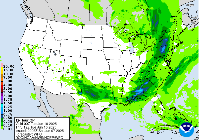
Valid 12Z Mon Jun 09 2025 - 12Z Tue Jun 10 2025
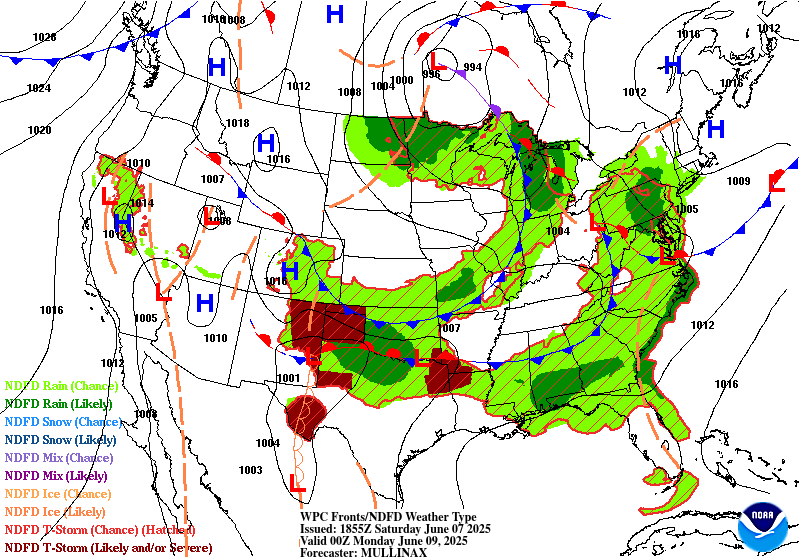
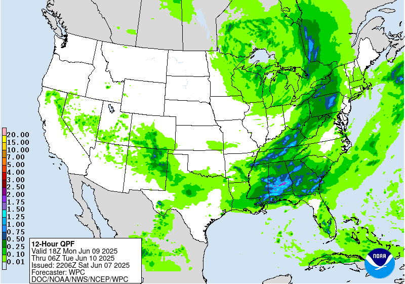
...THERE IS A MARGINAL RISK OF EXCESSIVE RAINFALL ACROSS A LARGE
PORTION OF THE SOUTHERN AND EASTERN UNITED STATES...
Very few changes were made to the existing Marginal Risk, which
encompassed a broad area in the southern and eastern United States
along and ahead of a slowly advancing cold front. The air mass
ahead of the front will be characterized by above normal PWs and
widespread moderate to strong instability. Therefore, a day with
abundant areas of active convection containing relatively high
rain rates is expected. Confidence is not very high at this time in
the detail, particularly where concentrated areas of heavy rainfall
and/or localized extreme events may occur. However, based on
today's model guidance, this seems most likely in the following
locations, where a Slight Risk upgrade may eventually be needed:
1. Eastern Great Lakes and Central Appalachians. Instability is
projected to be more limited in these areas, but recent rainfall
may lead to wet conditions in advance, and there is better model
consensus on areas of over 1 inch QPF.
2. The Gulf Coast. A combination of strong instability and high PWs
would support organized convection and high rain rates, but there
is less model agreement on placement.
3. West Texas into Northeast New Mexico. PWs will be increasing and
quite anomalous (over the 90th percentile) along with fairly
strong instability. These areas will be removed from stronger mid-
upper level flow, likely leading to overall slower storm motions.
Lamers
Day 3 threat area:
www.wpc.ncep.noaa.gov/qpf/99epoints.txt
Extended Forecast Discussion
NWS Weather Prediction Center College Park MD
258 PM EDT Sat Jun 7 2025
A trailing frontal boundary draped generally west to east across
the South will provide focus for numerous showers and thunderstorms
through much of next week. The Days 4 and 5 Excessive Rainfall
Outlooks (valid Tuesday and Wednesday) reflect this. For Day 4, a
Marginal Risk stretches from the southern Rockies and Plains into
the central Gulf Coast states along and ahead of the front. Model
guidance has converged better on an excessive rainfall threat
centered over west-central Texas on Tuesday, with potential for
convection to remain Tuesday morning before a nocturnal round of
storms with heavy rain rates Tuesday night. Thus will upgrade to a
Slight Risk in this area where ample moisture and instability
interacts with the front and a shortwave aloft. By Day 5/Wednesday,
continue to carry a Slight Risk in parts of Texas, expanded
somewhat from the previous issuance to cover possible multiple
convective complexes and also the increasing spread in position of
heaviest rain. By Thursday-Friday, the frontal boundary should
gradually lift northward, with heavy rainfall moving into Oklahoma
and the Lower/Middle Mississippi Valley. Much of this area has been
wet as of late and will need to be monitored for flooding concerns
later this week.
The northern portion of this front should be quicker to move
through the East, but heavy rainfall is possible along the boundary
amidst ample moisture and instability and favorable upper level
dynamics. A Marginal Risk for the interior Northeast remains on the
Day 4 ERO. Elsewhere, additional shortwave energy interacting with
a frontal boundary across the northern tier will bring showers and
storms across parts of the northern Rockies into the Upper
Midwest. Moisture anomalies should be above the 90th percentile in
Montana, prompting a Marginal Risk there for the Day 5/Wednesday
ERO. Additionally, convection is likely to move through the north-
central U.S. along the cusp of the instability gradient. Will
maintain a Marginal Risk there as well for Wednesday, with some
broadening but a general southward adjustment from the previous
shift per model trends. Additional rounds of rain and storms are
possible in the northern tier through late next week.
Much above normal temperatures will continue into Tuesday for the
Northwest, with anomalies of +20-25F likely for one more day. A few
record highs are possible there along with moderate HeatRisk, and
moderate to major HeatRisk is forecast to expand south through the
Great Basin and Desert Southwest. Western heat should gradually
moderate as the week progresses, but could remain above normal
especially over the Great Basin. Most other areas look to be within
a few degrees of average by later next week, though the Mid-
Atlantic could see temperatures of 5-10F above average Thursday-
Friday with highs reaching the 90s. Average temperatures are
reaching the 90s in the southern tier this time of year though,
and the subtropical ridge will produce hot and humid conditions and
warm overnight lows.
Tate/Santorelli


